Iceland waterfalls guide — the 15 best falls you need to see
Reykjavik: South Coast black Beach waterfalls full day
What are Iceland's best waterfalls?
Gullfoss, Seljalandsfoss, Skógafoss, Dettifoss, and Goðafoss are the five most visited. Seljalandsfoss is unique because you can walk behind the curtain. Dettifoss is the most powerful in Europe by volume. Most are accessible year-round, though winter access requires a 4WD for some.
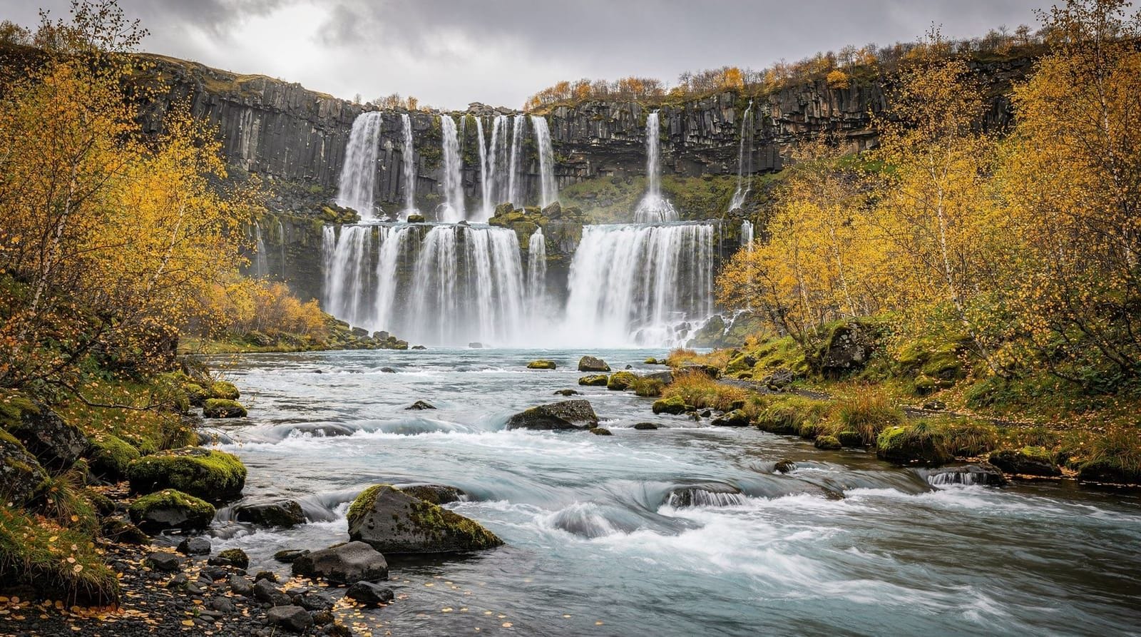
Iceland has more than 10,000 waterfalls. That number is not a tourist-brochure exaggeration — the combination of glacial meltwater, heavy rainfall, and dramatic volcanic terrain means water is constantly finding new paths over basalt cliffs and lava fields. The result is a country where you cannot drive the Ring Road for more than an hour without pulling over to look at something genuinely impressive.
This guide covers the 15 waterfalls worth going out of your way for, ranked roughly by spectacle and practical value. It also flags which ones get overcrowded, which have genuine hazards, and which are free versus paid parking.
Why Iceland has so many waterfalls
The geology is decisive. Iceland sits on the Mid-Atlantic Ridge, where the Eurasian and North American tectonic plates are pulling apart. The resulting volcanic activity produced a landscape of flat-topped table mountains — called móbergs — and layered basalt plateaus that water pours off in curtains and plunges.
The glaciers covering 11% of the country — including Vatnajökull, Langjökull, and Mýrdalsjökull — are the primary water source. Glacial meltwater, augmented by 1,500–2,000 mm of annual precipitation on the south coast, keeps rivers running fast and full year-round. In spring and early summer (May–June), snowmelt adds further volume, making this the best season to photograph white-water drama.
The south coast cluster (Ring Road, Route 1)
The south coast is Iceland’s most visited stretch, and for good reason — you pass three major waterfalls within 40 km of each other, all within easy reach of Reykjavík.
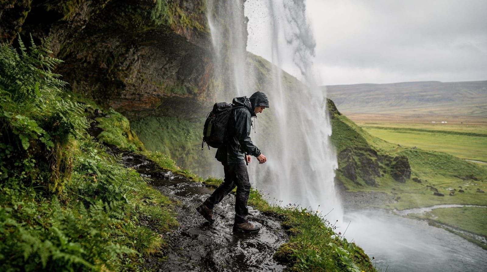
Seljalandsfoss — the walk-behind waterfall
Height: 60 m | Parking: 900 ISK (~€6) | Distance from Reykjavík: 120 km, about 1.5 hours
Seljalandsfoss is the photograph everyone posts. Water drops from the rim of an old sea cliff into a wide pool, and a footpath runs behind the curtain through a shallow cave. The path is wet and slippery year-round — non-negotiable waterproofs are essential, and the cave entrance is sometimes frozen shut in winter (November–March).
The falls are lit at night in summer, which draws crowds until 11 pm or later during midnight sun season (late May–early July). If you want the place to yourself, arrive before 8 am or after 9 pm. Read more practical details on our Seljalandsfoss destination page.
A short walk north leads to Gljúfrabúi, a narrower gorge where water disappears inside a canyon crack. Few visitors find it; it takes only 10 minutes extra.
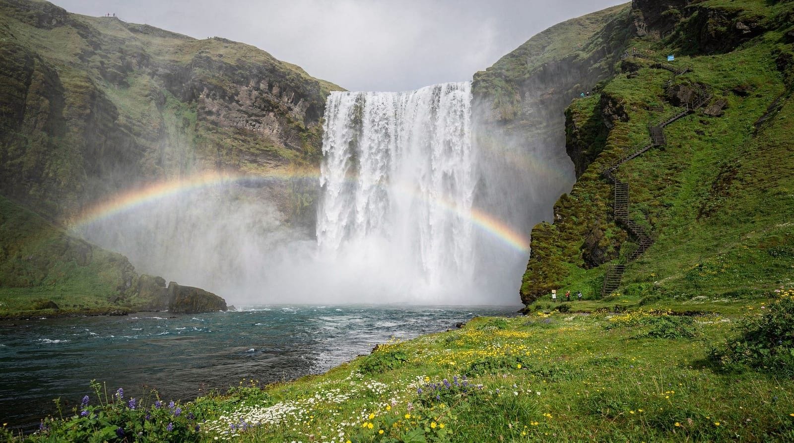
Skógafoss — rainbows guaranteed
Height: 60 m | Width: 25 m | Parking: Free | Distance from Seljalandsfoss: 30 km east
Skógafoss consistently produces double rainbows on sunny mornings — the mist column is so dense that the conditions are reliable. Climb the 527 steps up the wooden staircase for the top-down view and access to a riverside hiking trail leading toward Fimmvörðuháls pass.
The falls are crowded almost all day in summer (June–August). The parking area fills by 9 am on peak days. A small campsite sits directly beside the falls — staying there gets you solo morning access before day-trippers arrive. See our Skógafoss guide for full details.
A full-day south coast tour from Reykjavík typically covers both Seljalandsfoss and Skógafoss, plus Reynisfjara black sand beach and sometimes Dyrhólaey. This is the most efficient way to see all three if you don’t have a car.
Skógar hidden waterfalls
The trail along the Skógá river above Skógafoss passes 26 smaller falls before reaching Fimmvörðuháls. The first 3–4 km is a straightforward walk; after that, you enter highland terrain and need appropriate equipment. Even a one-hour walk upstream is rewarding and completely uncrowded.
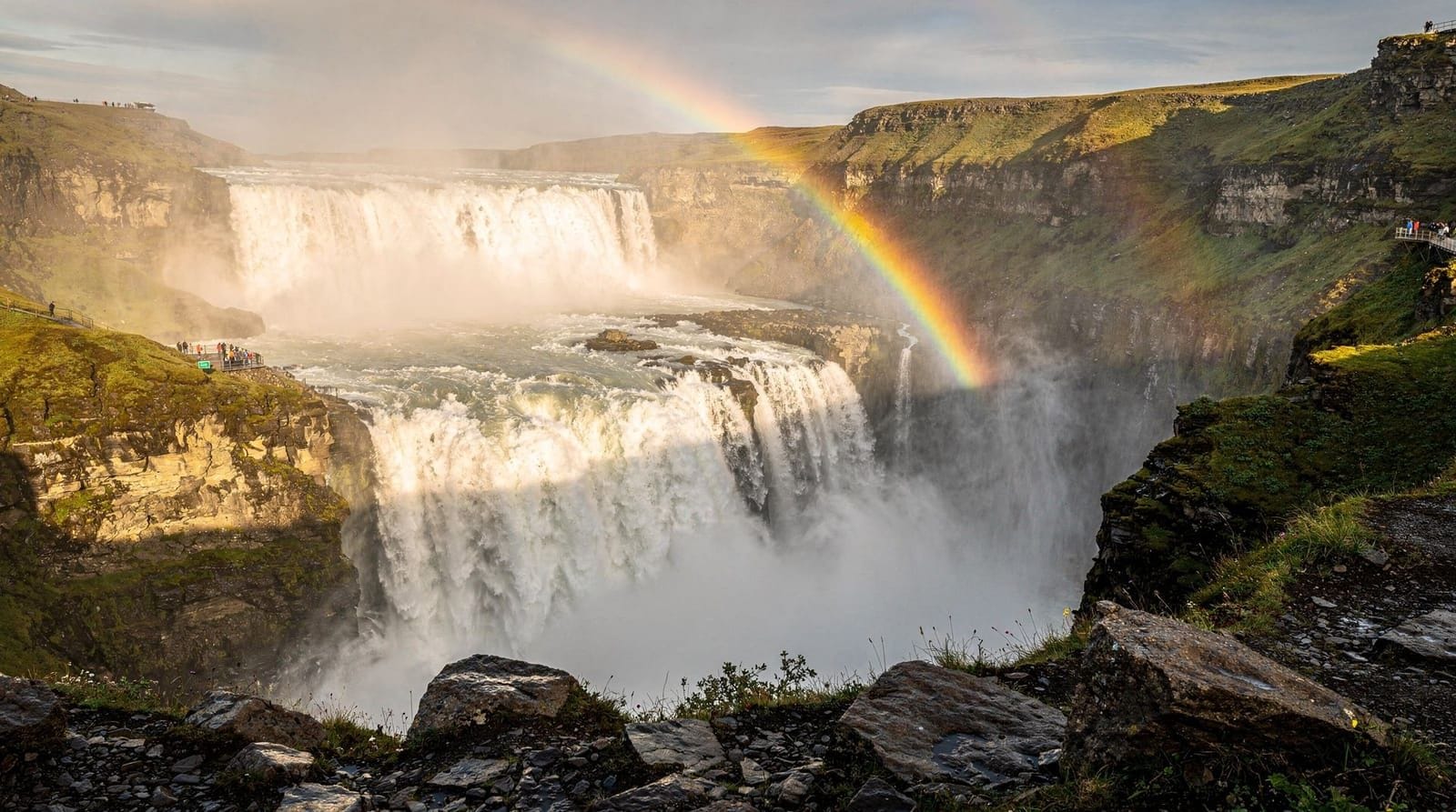
Gullfoss — the Golden Circle anchor
Height: 32 m (two-step) | Combined width: 70 m | Parking: 700 ISK (~€5) | Distance from Reykjavík: 125 km, 1.5–2 hours
Gullfoss is Iceland’s most famous waterfall and the signature stop on the Golden Circle. The river Hvítá drops in two cascades at right angles, then disappears into a 70 m wide crevice. The visual impact comes from volume — up to 140 m³/s in summer — and the sense that the water is swallowing itself underground.
The free upper viewpoint requires no fitness. The lower viewpoint, which puts you level with the second falls, requires walking about 400 m on a maintained trail. Getting close means getting wet; a packable rain jacket is not optional here.
The classic Golden Circle day tour from Reykjavík covers Gullfoss, Geysir hot spring area, and Þingvellir National Park. Full-day tours (10–11 hours) give enough time at each site without feeling rushed.
Our full Gullfoss guide covers driving directions, best photo times, and winter access conditions.
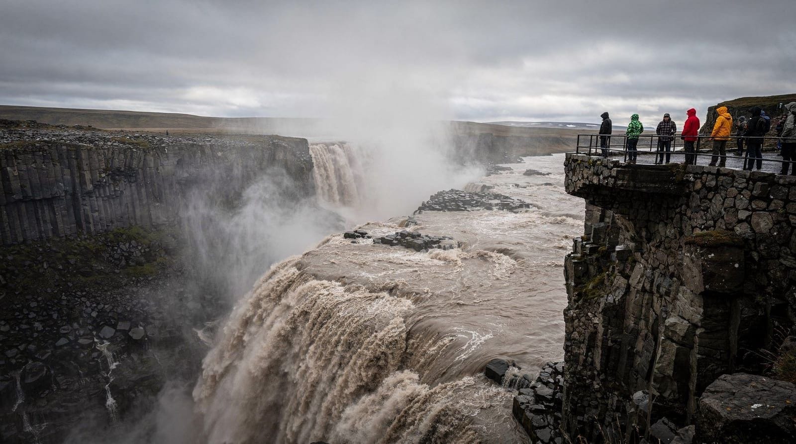
Dettifoss — Europe’s most powerful waterfall
Height: 44 m | Width: 100 m | Flow: up to 500 m³/s in summer | Distance from Akureyri: 160 km, about 2 hours
Dettifoss sits in the northeast of Iceland within Vatnajökull National Park, and it is genuinely unlike anything on the south coast. The scale is overwhelming — the falls are 100 m wide, and the roar is audible a kilometre away. Water is glacier-grey, heavily laden with sediment, which contrasts with the black basalt canyon.
Two roads reach Dettifoss from either side of the Jökulsá á Fjöllum river. Road 862 (east bank, paved) gives the most common viewing platform. Road 864 (west bank, gravel) offers fewer visitors and a slightly different angle. In winter, both roads may require a 4WD with good tyres.
Plan to combine Dettifoss with Selfoss (1 km upstream — smaller but beautiful) and Hafragilsfoss (2 km downstream). Read the full Dettifoss guide before driving north.
Goðafoss — waterfall of the gods
Height: 12 m | Width: 30 m | Parking: Free | Distance from Akureyri: 50 km east, about 45 minutes
The name references a specific historical event: in the year 1000, the law-speaker Þorgeir Ljósvetningagoði threw his Norse idol statues into the falls after Iceland’s parliament voted to adopt Christianity. The drama of the history adds weight to what would otherwise be a mid-ranking waterfall.
Goðafoss spreads in a horseshoe arc across the Skjálfandafljót river, and unlike most Icelandic waterfalls, you can view it safely from both banks without any real effort. It sits directly on Route 1, making it the most accessible major waterfall in Iceland. Expect it to be busy when cruise ships are docked in Akureyri. See the full Goðafoss guide.
Dynjandi — the westfjords’ crown jewel
Height: 100 m | Distance from Ísafjörður: 80 km | Parking: Free
Dynjandi (also called Fjallfoss) is the most remote major waterfall on this list, located in the Westfjords at the end of a winding single-lane road. The falls cascade in a broad triangular curtain from a plateau edge, widening from 30 m at the top to nearly 100 m at the base. Below Dynjandi, five smaller falls tumble down the same hillside.
The remoteness means you may have the entire viewing area to yourself, especially outside July and August. The access road from Ísafjörður takes roughly 90 minutes. See details at Dynjandi destination page.
Háifoss and Granni — the highland pair
Height: Háifoss 122 m | Road access: F225, 4WD required
Háifoss is Iceland’s second-highest waterfall and almost entirely unknown outside dedicated hikers. It plunges from the edge of the Búðahraun lava field into the Fossá river canyon alongside Granni (literally “the neighbour”), a narrower fall dropping the same distance. The two falls are best seen from the canyon rim.
The access road F225 requires a medium-sized 4WD; the river crossings are shallow but present. Nearest services are at Landmannalaugar. This is a day trip from Reykjavík (roughly 180 km, 3+ hours). There is no tourist infrastructure here — no café, no ranger, no first aid post.
Ófærufoss — Eldgjá canyon waterfall
Height: 40 m | Road access: F223, 4WD required | Accessible: July–August only
Ófærufoss sits inside Eldgjá volcanic canyon, a 270 km² lava caldera in the southern highlands. A double-drop waterfall once had a natural basalt arch spanning its face — the arch collapsed in the 1990s, but the falls remain spectacular. Access requires crossing the highland interior via F223, which is generally open from mid-July to early September depending on the year.
This is multi-day trip territory — pair it with Landmannalaugar hiking or the highlands summer itinerary.
Bruarfoss — the blue waterfall
Height: 3 m | Colour: electric blue | Access: 3.5 km hike each way
Bruarfoss is short and falls only 3 metres, but the turquoise-blue water colour makes it stand out completely from every other Icelandic waterfall. Water flows from geothermal ground through the Hvítá tributary and picks up a mineral-blue hue. The trailhead is near the village of Brekkuskógur, about 8 km from Gullfoss — most Golden Circle tours skip it entirely.
The walk takes roughly 45 minutes each way on a flat gravel path. Wear waterproof shoes; parts of the path are boggy. It is worth it.
Kirkjufellsfoss — the photography pair
Height: 7 m | Location: Snæfellsnes peninsula, beside Route 54 | Parking: Free
Kirkjufellsfoss is not impressive on its own. It becomes iconic when combined with the backdrop of Kirkjufell mountain in a single composition. This is arguably Iceland’s most-photographed scene, used in countless travel campaigns and recognizable from fantasy TV series.
The falls are 5 minutes from the road. The mountain requires a proper hike (2–3 hours, exposed ridge). Most visitors photograph both from the lower level and move on in 20 minutes. See the Kirkjufell photography guide for exact camera positions and lighting windows. Also see the Kirkjufell destination page.
Aldeyjarfoss — basalt columns and contrast
Height: 20 m | Road access: Route 842, gravel, standard car usually fine in summer
Aldeyjarfoss sits on the Skjálfandafljót river in the northern highlands, surrounded by hexagonal basalt columns that create a geometric frame around the falls. Unlike the heavily-visited south coast falls, Aldeyjarfoss sees a fraction of the traffic — perhaps 100 visitors on a busy summer day.
The access road from the Ring Road (Route 1 near Goðafoss) is about 35 km of rough gravel. In dry summer conditions a regular car makes it, but confirm current road conditions at road.is before setting out.
Foss á Síðu — the roadside cascade
Height: 30 m | Location: Route 1, 25 km east of Kirkjubæjarklaustur | Parking: Small pull-off
This waterfall falls directly onto the main road during periods of high wind, which creates the memorable optical illusion of a waterfall flowing upward. In strong southerly winds, water blows back over the cliff edge and mists the road. Remarkable to see in person, impossible to capture in a static photograph. It has no formal parking area — pull off carefully.
Planning a waterfall road trip
South coast day trip
The optimal sequence from Reykjavík is: Seljalandsfoss (1 hour) → Gljúfrabúi (30 min) → Skógafoss (1 hour including staircase) → Reynisfjara black sand beach. Total driving: about 350 km round trip, 5–6 hours driving, comfortably a day trip. See the south coast day trip guide for the full itinerary.
Small-group south coast tours (max 12–16 passengers) stop longer at each waterfall than large-bus options, and the guides know the best angles and timings. If you’re choosing between tour sizes, the smaller format is worth the premium.
North Iceland waterfall route
From Akureyri: Goðafoss (45 min east on Route 1) → Aldeyjarfoss (1.5 hours on gravel, summer only) → Dettifoss (2 hours further east). This is a long day — 400+ km total — or better as part of a north Iceland 4-day itinerary.
Westfjords
Dynjandi is a half-day from Ísafjörður. If you’re driving the Westfjords circuit, plan to spend 1.5 hours at Dynjandi including the walk up the hillside falls chain. See the Westfjords itinerary.
Safety and photography tips
Iceland’s safety authority (safetravel.is) records dozens of waterfall incidents each year. The three main causes: standing on wet rocks near the base, ignoring fences and barriers, and approaching swollen rivers during snowmelt without assessing crossing depth.
Practical rules:
- Assume every rock near a waterfall is slippery, even if it looks dry
- Stay on maintained paths; worn-down patches in the vegetation mark where people have slipped
- In wet weather, the spray radius doubles — a light rain jacket is not adequate; you need full waterproofs for Gullfoss and Skógafoss base approaches
- Best light for photography: overcast days eliminate harsh shadows; summer sunrises (3–4 am in June) give golden light with no crowds; winter gives low-angle light all day
- For long-exposure shots of the falls themselves, you need a sturdy tripod — handheld shots blur even at 1/250s in many conditions
See the full Iceland photography guide and long-exposure waterfall photography guide for specific settings recommendations.
Frequently asked questions about Iceland’s waterfalls
Which Icelandic waterfall is the tallest?
Glymur, in west Iceland, is generally cited as the tallest accessible waterfall at 198 m. It requires a moderate 2-hour hike from the car park, including a river crossing. However, several falls in remote highland areas exceed it in height but have no trails. Háifoss at 122 m is the tallest easily verifiable roadside waterfall.
Can I visit waterfalls in winter?
Yes, but conditions vary dramatically. Seljalandsfoss path behind the falls is typically icy and closed from November through March. Skógafoss and Gullfoss are open year-round, though the base paths become icy and sometimes impassable. Dettifoss access may require 4WD and checking road.is. In very cold winters, some smaller falls freeze partially into dramatic ice sculptures.
Is there an entrance fee for waterfalls?
Most are free. Exceptions: Seljalandsfoss and Skógafoss charge parking fees (around 700–900 ISK / €5–6 in 2025). Gullfoss charges 700 ISK for parking. No Icelandic waterfall charges admission to view the falls themselves.
How long does it take to see Gullfoss?
Allow 1–1.5 hours for the upper and lower viewpoints and the short walk to the canyon edge. If you are combining it with the Golden Circle full itinerary including Geysir and Þingvellir, plan for a full day (8–10 hours from Reykjavík).
What is the best time of year for waterfall photography?
Late May to mid-June balances maximum water volume (snowmelt + full rivers) with long daylight hours, including the possibility of sunrise light as early as 3 am. July and August have peak crowds but still excellent conditions. Autumn (September–October) gives dramatic skies and lower visitor numbers.
Are Icelandic waterfalls safe to photograph from?
Generally yes, if you stay on marked paths and behind barriers. The highest-risk spots are Gullfoss lower path (extremely wet from spray), Skógafoss base (slippery pebbles), and any unmarked viewpoints near Dettifoss. The canyon walls around Dettifoss are unstable — several sections have collapsed in recent years.
Can I swim in or under the waterfalls?
No. Water temperatures in glacial rivers range from 1–5°C year-round. Even in summer, immersion causes rapid incapacitation from cold shock. The pools beneath major waterfalls also have violent subsurface currents. Swimming in or under Icelandic waterfalls is actively dangerous regardless of season.
Top experiences
Bookable activities with verified prices and instant confirmation on GetYourGuide.

Top experiences
Best-rated activities across GetYourGuide and Viator.

Ice Cave by Katla Volcano Super Jeep Tour from Vik
- Viator

Puffin and Volcano Tour with Ebbi
- Viator

Dynjandi Waterfall & Farm Visit Tour from Isafjordur Port
- Viator

3,5-Hour Sightseeing Tour To Dynjandi Waterfall
- Viator

Volcano ATV Tour
- Viator

Lake Myvatn Day Tour and Godafoss Waterfall for Cruise Ships from Akureyri Port
- Viator