Dettifoss travel guide
Dettifoss — Europe's most powerful waterfall, 100m wide and 45m tall. West vs east bank, how to reach it from Akureyri, and real driving conditions.
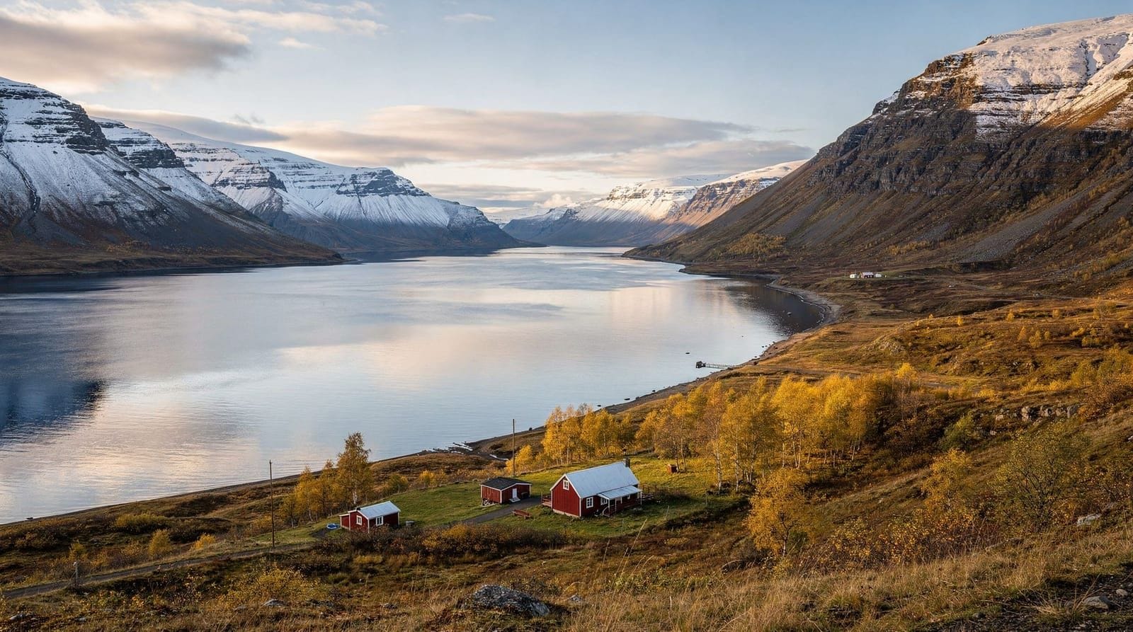
Akureyri: Dettifoss and Godafoss waterfalls
Quick facts
- Best time
- Jun–Aug for access; winter for ice (road may close)
- Days needed
- 2–3 hours including drive from Mývatn
- Getting there
- 140 km from Akureyri; ~2h via Ring Road and Route 862 or 864
- Budget per day
- Free entry; budget for fuel — roads are long
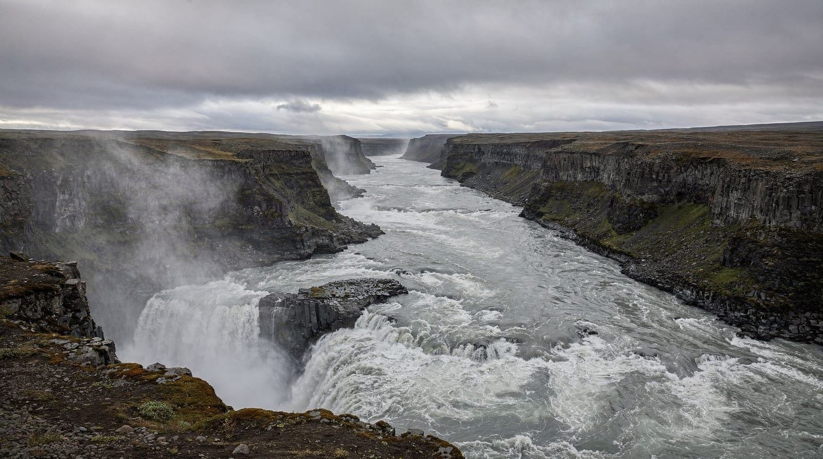
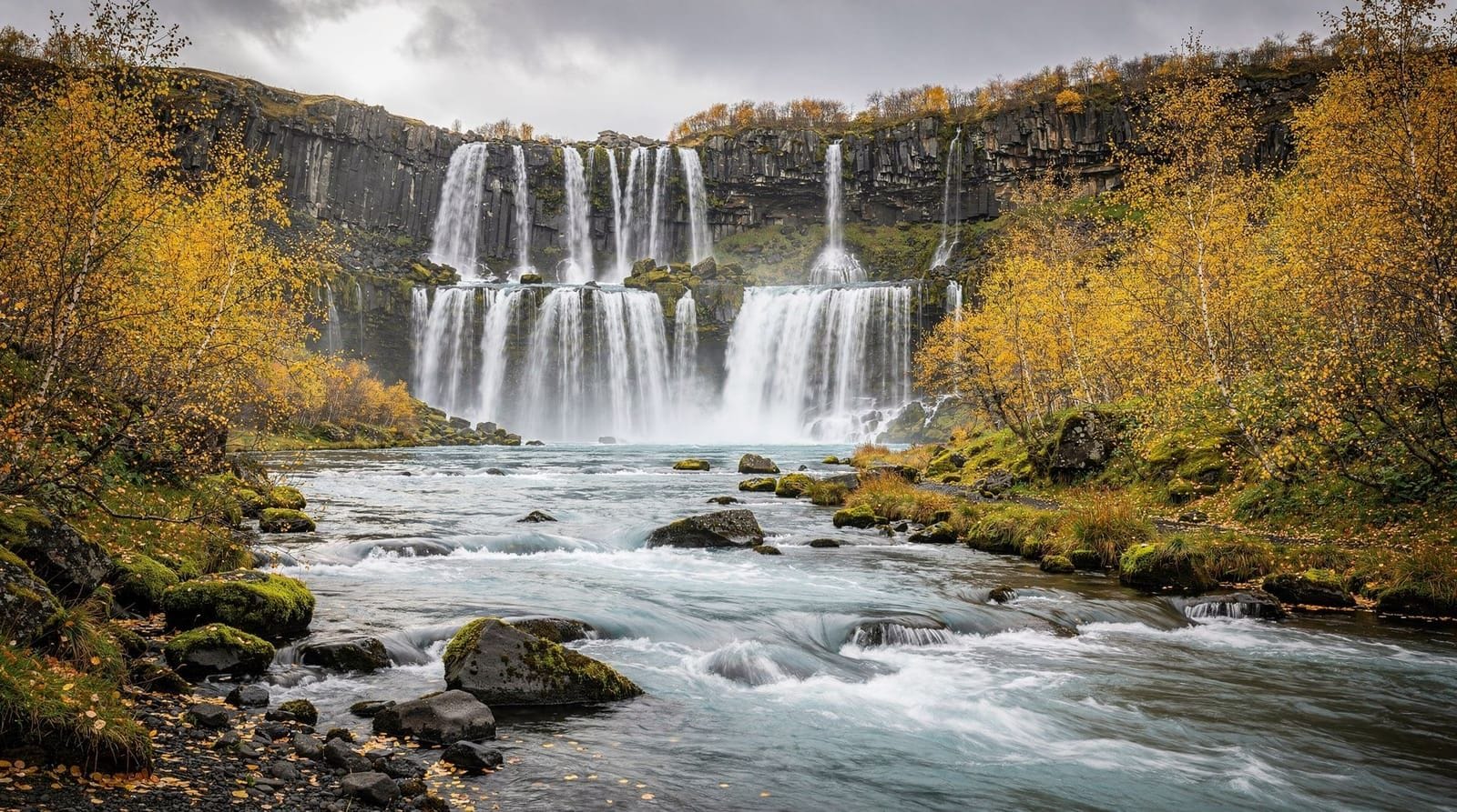
Dettifoss makes itself known before you see it. The roar carries for several hundred metres, and the spray column is visible from the car park. When you reach the rim, the scale is immediate: 100 metres wide, 44 metres tall, 193 cubic metres of water per second in peak summer flow — the most powerful waterfall in Europe by discharge. The Jökulsá á Fjöllum river drains Vatnajökull glacier and crosses the Ódáðahraun lava desert before dropping here into a 100-metre-deep canyon. Nothing about Dettifoss is subtle.
The falls are in Vatnajökull National Park, accessible from two sides: the west bank (Route 862, sealed road) and the east bank (Route 864, partly gravel). Both banks have car parks and paths to viewpoints. The west bank is the more popular and photogenic; the east bank is quieter. Allow 2–3 hours for the visit including the approach drive from Lake Mývatn, which is the most common launching point.
Getting to Dettifoss
From Akureyri and Mývatn
The most common approach is from the west, via the Ring Road and Route 862:
From Akureyri: Head east on the Ring Road past Goðafoss and Mývatn, then continue east for another 25 km past the Mývatn turnoff to the Route 862 junction (signed Dettifoss). Take Route 862 north for 24 km to the west bank car park. Total from Akureyri: approximately 140 km, 2 hours.
From Mývatn (Reykjahlíð): Continue east on the Ring Road for approximately 25 km, then north on Route 862 for 24 km. About 1 hour from the lake.
Route 862 is fully sealed (paved) and suitable for standard 2WD cars.
East bank approach (Route 864)
The east bank car park is accessible via Route 864, which branches off the Ring Road further east and runs parallel to the canyon. Route 864 is a gravel road that can be rough — a 2WD is technically sufficient but a higher-clearance vehicle is more comfortable. The east bank car park is approximately 3 km downstream (north) of the west bank car park, connected by a path along the canyon rim. From the east bank you see the falls from the opposite side and slightly downstream.
In summer both roads are typically open. In early season (May) or after heavy rain, Route 864 can be difficult; check conditions at road.is.
Guided tours from Akureyri
If you prefer not to drive, organised tours from Akureyri cover Dettifoss as part of the Diamond Circle or as a dedicated waterfall route.
Akureyri day trip: Dettifoss and Goðafoss waterfalls — guided, transportation included.
Full Diamond Circle from Akureyri — includes Dettifoss, Mývatn, Goðafoss, and more.
West bank vs east bank
West bank (Route 862): The most-visited side. From the car park, a 10-minute walk on a gravel path leads to the canyon rim viewpoint. You look north at the full horseshoe of the falls with the canyon stretching beyond. Spray is substantial in high flow; waterproof clothing is useful. The platform is relatively crowded in summer (July–August). The path continues south along the canyon to Selfoss waterfall (see below).
East bank (Route 864): Accessed separately. The viewpoint is at roughly the same elevation as the west bank but on the other side. You see the falls slightly differently — the eastern wall of the canyon is prominent. Fewer visitors on this side. If time allows, seeing both sides is worthwhile; combining requires driving around (40 km) rather than crossing.
Selfoss waterfall
About 1 km upstream (south) from Dettifoss, the same river drops over Selfoss — a wider, lower cascade with a different character. The walk from the Dettifoss west bank car park to Selfoss takes 20–25 minutes on a marked path. Selfoss is less dramatic than Dettifoss but often less crowded and worth the walk. The path passes close to the canyon edge in places; stay on marked trails.
Hafragilsfoss
About 2 km downstream (north) from Dettifoss on the canyon rim path is Hafragilsfoss, another significant falls at 27 metres. The path from Dettifoss is signed. Adding Hafragilsfoss extends the visit by about 45–60 minutes. This waterfall is also visible from the east bank.
Scale and geology
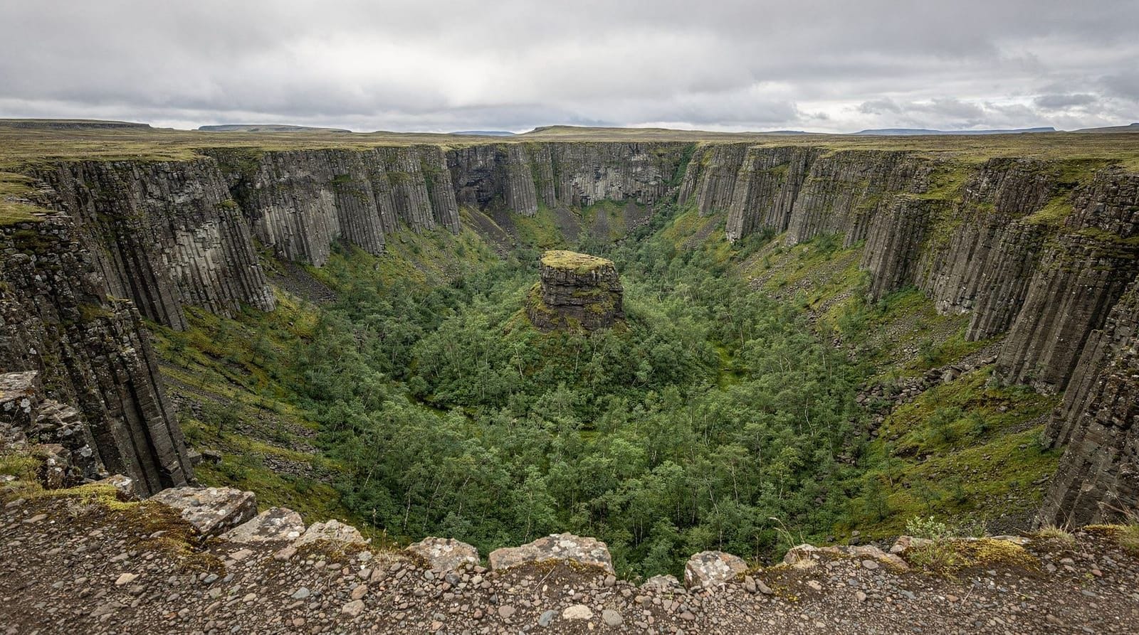
The Jökulsárgljúfur canyon in which Dettifoss sits was carved entirely by jökulhlaup (glacier outburst floods) in the last 10,000 years. The most recent major flood occurred approximately 2,500 years ago. Each flood event was catastrophically large — carrying 200–300 times the current river volume — and cut the canyon rapidly. Dettifoss itself has retreated roughly 2 km upstream from its original position due to ongoing erosion. The canyon continues northwest to Ásbyrgi, 30 km downstream.
The dark rock of the canyon walls is Tertiary basalt, approximately 8–12 million years old, which erupted across the North Atlantic landmass before Iceland’s current volcanic zone was established.
Practical notes
Entry fee: Free. The car parks are free, the paths are free.
Facilities: A small service building at the west bank car park has toilets (operational in summer). No café or food service at the falls — bring your own.
Spray and clothing: The spray from Dettifoss reaches the viewpoints on all but the calmest days. A waterproof jacket is useful, not optional in high flow. The paths can be slippery near the falls.
Safety: The canyon rim has no fence in most places. The Jökulhlaup flood scarring on the canyon walls is a reminder of what the river is capable of. Stay on marked paths and keep well back from edges.
Crowds: July and August are busy — parking can fill by 10am. Arrive before 9am or after 6pm for the quietest conditions and better light. Midnight sun allows excellent photography at 11pm.
Winter access: Route 862 is generally kept open year-round on the southern section; the northern section near Dettifoss can close in serious winter weather. Route 864 is more frequently blocked. Check road.is. Dettifoss partly freezes in severe winters, creating dramatic ice formations at the edges.
Fitting Dettifoss into the Diamond Circle
Dettifoss is typically the most remote stop on the Diamond Circle. A logical order from Akureyri is: Goðafoss (morning), Mývatn (late morning), Dettifoss via Route 862 (early afternoon), then north on Route 864 or back via Route 862 to Ásbyrgi (afternoon), then west to Húsavík (late afternoon). Return to Akureyri via Route 85.
The Askja volcano (interior, F-road access) is sometimes combined with a Dettifoss trip for those with appropriate vehicles and time, as the Route 901/F88 approach passes near the Dettifoss area.
Frequently asked questions about Dettifoss
Why is Dettifoss called Europe’s most powerful waterfall?
Power in this context refers to discharge volume — the amount of water passing over the falls per second. Dettifoss averages 193 cubic metres per second and peaks above 400 m³/s in summer melt. This exceeds European rivals such as the Rhine Falls in Switzerland (700 m³/s at peak, but much lower average) and makes it the highest sustained discharge of any European waterfall. The figures come from long-term hydrological measurements; it is not a marketing claim.
Is Route 862 or Route 864 better for Dettifoss?
Route 862 (west bank) is sealed, easier to drive, and gives the most-visited viewpoint. Route 864 (east bank) is gravel and rougher but gives a quieter alternative view. For most visitors, Route 862 is the practical choice. If you have a suitable vehicle and time, doing both sides is worthwhile but requires driving around, not crossing.
Can I see both Dettifoss and Goðafoss in one day from Akureyri?
Yes — both are on or near the Ring Road east of Akureyri, roughly 50 km apart. A comfortable day route: Goðafoss (45 min from Akureyri, 30 min at falls), continue to Mývatn (45 min, 2 hours), continue to Dettifoss via Route 862 (45 min, 1–2 hours), return to Akureyri via the same route or via Ásbyrgi and Húsavík. Total day 9–11 hours depending on pace.
Do you need a 4WD to reach Dettifoss?
No, not in summer. Route 862 (west bank) is sealed and perfectly fine for standard 2WD. Route 864 (east bank) is gravel and can be rough, but a standard 2WD with good clearance manages it in dry conditions. In early season (May) or after heavy rain, Route 864 can be problematic; stick to Route 862 if in doubt.
What is the best time to photograph Dettifoss?
Early morning (before 9am) for softer light and fewer crowds. Midnight sun (late June–July) allows shooting in warm golden light at 10–11pm with the falls lit from a low angle. The spray creates rainbow effects on sunny afternoons — usually midday to early afternoon on the west bank viewpoint.
Is Dettifoss in Vatnajökull National Park?
Yes. The section of the Jökulsárgljúfur canyon including Dettifoss, Selfoss, Hafragilsfoss, and Ásbyrgi is part of the Vatnajökull National Park northern district. There is no entry fee for this part of the park.
Prometheus and popular culture
Dettifoss was the opening scene of Ridley Scott’s 2012 film Prometheus — a dark, mist-shrouded landscape where an alien being dissolves into the water. The location choice was deliberate: Scott described Dettifoss as “the most powerful and remote-feeling landscape in Europe.” The scene was shot on the east bank in overcast conditions, which suppresses the colour and emphasises the monochrome basalt.
Since Prometheus, Dettifoss has appeared in various travel and wildlife documentaries. The BBC Planet Earth series used footage of the falls to represent Iceland’s volcanic geology. This coverage has contributed to growing visitor numbers over the past decade, with the west bank car park reaching capacity on some summer days.
The Jökulsárgljúfur canyon trail
For committed hikers, a two-day trail runs the length of the Jökulsárgljúfur canyon from Dettifoss south to Ásbyrgi, covering approximately 33 km. The route passes Hafragilsfoss, Hljóðaklettar (a cluster of columnar basalt formations known as the “echo rocks”), the river gorge at Rauðhólar, and then the birch forest of Ásbyrgi. Campsites are located at Vesturdalur and Ásbyrgi. This is the best long-distance walk in North Iceland and sees relatively few hikers compared to the more famous Laugavegur route in the south. Good footwear, navigation skills, and self-sufficiency required. Check the Vatnajökull National Park website for current trail conditions before setting out.
Practical safety detail
The main west bank viewpoint has a low stone wall and some rope barriers near the most dangerous sections, but large areas of the rim are unfenced. Each year visitors are injured by falls near the canyon edge, almost always because they stepped off the marked path to get closer to the edge for photography. The rock surface near the falls is polished by spray and extremely slippery in wet conditions.
The canyon walls at Dettifoss are vertical — if you fall in, the current is not survivable. This is not overstating the risk; it is worth stating plainly because the visual drama of the falls encourages people to approach closer than is safe. The best photographs are taken from the established viewpoints.
Comparing Dettifoss with European waterfalls
The “most powerful in Europe” claim sometimes generates debate. For context:
- Rhine Falls (Switzerland): 700 m³/s peak discharge but 150 m³/s average; 23m tall, 150m wide
- Dettifoss: 193 m³/s average; 44m tall, 100m wide
- Hardangervidda waterfalls in Norway: Several exceed Dettifoss in height but not sustained discharge
The “power” designation refers to mean annual discharge, which is the standard hydrological measure. By that metric, Dettifoss is unambiguously the highest in Europe. By peak-flow metrics, some Alpine glacial rivers match it in spring melt, but those are not single-point waterfalls.
Access for the ring road traveller
Drivers completing the Ring Road clockwise from Reykjavík reach the Dettifoss junction on the north side of the Mývatn area. The signed Route 862 turnoff is approximately 25 km east of the Mývatn ring road junction. Anti-clockwise drivers coming from the east reach the Route 862 junction approximately 50 km west of Egilsstaðir.
Dettifoss is not on the Ring Road itself — it requires a 24 km detour north on Route 862 from the turnoff. Factor in 1.5–2 hours for the detour including visit time when planning a Ring Road day.
Comparing Iceland’s most powerful waterfalls
North Iceland has a concentration of exceptional waterfalls that allows direct comparison. In order of raw power:
- Dettifoss — 193 m³/s average discharge; 44m fall; 100m width. Most powerful in Europe.
- Goðafoss — significantly lower volume but the most photogenic shape in North Iceland.
- Selfoss — 1 km upstream from Dettifoss; broader, lower, less powerful but remarkably beautiful.
- Hafragilsfoss — 2 km downstream; narrow gorge, different character.
The south coast has its own stars — Skógafoss (62m), Seljalandsfoss (60m), Dynjandi in the Westfjords. But the Jökulsárgljúfur canyon section offers the highest concentration of powerful waterfalls in a single accessible area.
What the spray does to cameras
The spray from Dettifoss on the west bank viewpoint is substantial — fine water particles in an almost constant mist. Camera lens protection:
- Use a UV/clear filter as a sacrificial lens
- Pack a microfibre cloth and keep it in a pocket (not a bag — it will be wet)
- Lens hoods help marginally
- The spray is worst in wind from the south; check wind direction before approaching
For video work, the spray creates a cinematic atmosphere but will quickly fog an unprotected lens. Underwater housings are the only complete solution for extended shooting near the falls.
Visiting Dettifoss as part of the wider Vatnajökull National Park
Vatnajökull National Park is the largest national park in Europe by area, covering approximately 14,000 km². The park has two main visitor zones: the south (around the glacier and Skaftafell) and the north (the Jökulsárgljúfur canyon system). Dettifoss is the headline attraction of the northern section.
The two sections of the park are not connected by road — you need to drive around via the Ring Road (approximately 350 km between south and north park entrances). Planning a trip that includes both sections requires at least one full Ring Road loop, typically a 7–10 day itinerary. See the ring road 7-day itinerary for how to structure this.
Top experiences
Bookable activities with verified prices and instant confirmation on GetYourGuide.
Top-rated experiences in Dettifoss travel guide
Best-rated activities across GetYourGuide and Viator.

Whale Watching from Downtown Akureyri
- Viator

Big Whales & Puffins RIB boat tour from Húsavík
- Viator

East Glacial River – Grade 4 Rafting with Drysuits, North Iceland
- Viator

Top-Rated Family Rafting – Drysuits & Geothermal Hot Cocoa
- Viator

Original Big Whale Safari & Puffins Speedboat Tour from Húsavík
- Viator

Lake Myvatn Day Tour and Godafoss Waterfall for Cruise Ships from Akureyri Port
- Viator