Skaftafell — glacier hikes and waterfalls in Vatnajökull NP
Complete guide to Skaftafell in Vatnajökull National Park — glacier hikes on Falljökull, Svartifoss waterfall, hiking trails, visitor centre, and getting there.
Skaftafell: Half day Glacier hike
Quick facts
- Best time
- June–September for hiking; year-round for glacier access
- Days needed
- 1–2 (half-day minimum for Svartifoss + glacier viewpoint)
- Getting there
- ~3h 45min from Reykjavík (320 km east); 60 km west of Jökulsárlón
- Budget per day
- Park entry free; glacier hike 12,000–18,000 ISK / €78–117
Skaftafell was Iceland’s most popular national park for decades before it was incorporated into the larger Vatnajökull National Park in 2008. The name remains in use for the specific visitor area — the oasis of birch woodland, river valleys, and glacier tongues at the southern edge of the Vatnajökull ice cap.
The appeal is layered: Skaftafell offers some of the most accessible glacier hiking in Iceland (no super-jeep required), a famous waterfall with basalt columns, a good trail network for half-day and full-day hikes, and proximity to Jökulsárlón glacier lagoon 60 km to the east. It is the logical combination partner for a Jökulsárlón visit.
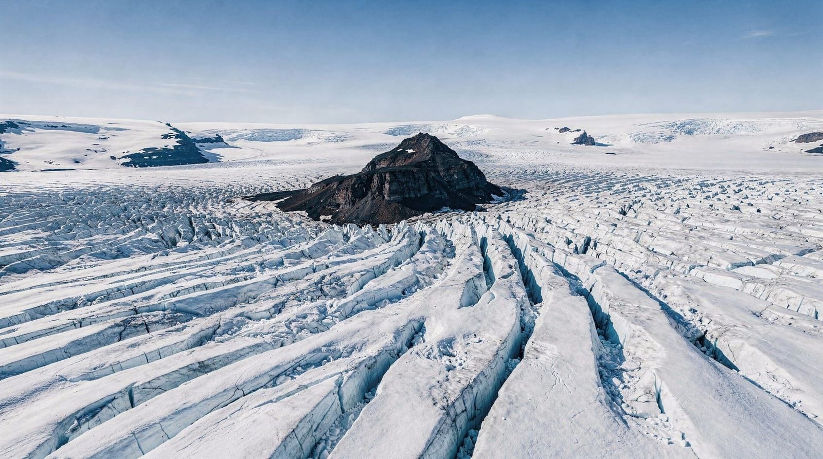
The glacier tongues
Two glacier tongues from Vatnajökull descend toward Skaftafell: Falljökull and Skaftafellsjökull. Both are accessible on guided hikes departing from the Skaftafell visitor centre car park.
Skaftafellsjökull is the easier and more frequently visited. A well-maintained gravel path leads from the car park to the glacier margin in about 20–25 minutes on foot. You can approach the glacier margin without a guide but should not access the glacier surface itself — crevasses are not visible at the margin and the surface ice is unstable and slippery. A protective railing marks the approved approach limit.
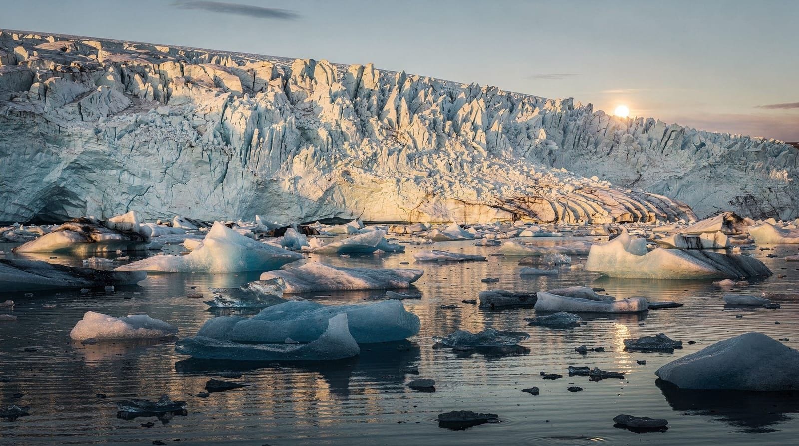
Falljökull is the glacier used for most commercial glacier hike operations. The walk from the car park to the glacier takes about 35–45 minutes across moraine. Guided hikes then take you onto the glacier surface with crampons, helmets, and harnesses (provided). Standard hike duration is 3–4 hours including the approach walk. Difficulty is moderate — manageable for most people in reasonable physical condition.
Skaftafell half-day glacier hike — 3 hours on Falljökull, crampons and helmet included, guides certifiedIce quality at Skaftafell glaciers is different from the crystal-blue ice cave experience at Jökulsárlón. The surface of the glacier is grey-brown from volcanic ash, heavily crevassed, and frankly spectacular in a raw industrial way. If you want to walk on Vatnajökull and understand how glaciers work from the inside, Skaftafell is more visceral than an ice cave tour.
Svartifoss waterfall
Svartifoss (Black Falls) is a 20-metre waterfall framed by vertical black basalt columns — more perfectly formed and more dramatic than even those at Reynisfjara. The hexagonal columns here stand 10–15 metres tall on both sides and behind the falls, creating a natural cathedral setting.
The walk to Svartifoss from the visitor centre takes about 45 minutes one-way on a well-maintained path with steady but manageable elevation gain (approximately 100 metres). The trail is signposted from the visitor centre and car park.
From Svartifoss, the trail continues up to a viewpoint over the entire Skaftafell oasis and the glacier tongues below (total additional 30–40 minutes from Svartifoss). Continuing further leads to the highland viewpoint (Sjónarnípa) with views extending to the coast.
The Svartifoss design has directly influenced Icelandic architecture. Hallgrímskirkja church in Reykjavík, the National Theatre, and several other landmark Icelandic buildings cite Svartifoss as an inspiration for their vertical columnar forms.
Trail network
Skaftafell has around 18 km of marked trails from easy to moderate difficulty. The most popular routes:
Svartifoss loop (5 km, 2–3 hours): From the car park, up to Svartifoss, to the glacier viewpoint at Sjónarnípa, then back down via a different path. Moderate.
Glacier viewpoint walk (4 km, 1.5–2 hours): From the car park, direct to the Skaftafellsjökull glacier margin, with a viewpoint overlook en route. Easy to moderate.
Kristínartindar summit (14 km, 5–7 hours): The full mountain hike to the highest ridge in the Skaftafell area, with views of the entire Vatnajökull ice cap. Only for fit, experienced hikers in good weather with navigation skills.
All trails are marked with posts; the visitor centre provides free maps. Some upper-elevation trails are closed or snowbound from October to May.
The visitor centre
The Skaftafell visitor centre (operated by Vatnajökull National Park) is a good resource: it has exhibitions on the geology and ecology of the park, current trail conditions, and staff who can advise on glacier hike operators and independent walking routes. Toilets and a basic café are available. The centre is open daily year-round, with extended summer hours.
A petrol station (N1) adjacent to the visitor centre car park is an important practical stop — it is approximately 75 km to the next reliable eastbound fuel (at Höfn), and west of Skaftafell the next petrol is at Kirkjubæjarklaustur (50 km west).
Practical information
Car park: Free, large, adjacent to the visitor centre. The camping area is in a separate zone behind the visitor centre and charges a small fee (around 1,800 ISK / €12 per person per night).
Camping: The Skaftafell campsite is one of the best-located in Iceland — inside the national park, surrounded by birch woodland, with the glacier visible from the tents. Book via National Park during July and August.
Food and accommodation: The visitor centre café serves hot food and drinks. Skaftafell itself has no hotel; the nearest accommodation is Hótel Skaftafell (~20 km west) or in the Kirkjubæjarklaustur area. For the eastern approach, the Fosshotel Glacier Lagoon near Jökulsárlón is the closest higher-end option.
Weather: Skaftafell is in the rainshadow of Vatnajökull and tends to be slightly drier than the coast west of Vík, but conditions change rapidly. The glacier creates its own microclimate, with cold katabatic winds descending from the ice cap even on otherwise warm days. Bring a windproof layer regardless of forecast.
Skaftafell extra small-group glacier hike — maximum 8 participants, longer time on the ice, advanced routeGeology and the Skaftafell oasis
Skaftafell sits at the edge of the Skeiðarársandur — a vast outwash plain (sandur) created by repeated glacial floods from the Vatnajökull ice cap over thousands of years. The flat, dark sand plain extending south of the visitor centre to the sea is one of the largest sandur areas in the world, roughly 1,000 square kilometres.
The birch woodland at Skaftafell itself is anomalous for Iceland, which lost most of its forests after the settlement period. The trees here survive because the surrounding terrain shelters them from the worst of the southerly storms, and the microclimate created by the adjacent glacier is slightly warmer than the surrounding plain. The woodland is protected as part of the national park.
Looking north from the visitor centre, the view of the Skaftafellsjökull glacier descending between bare dark ridges is one of the classic Icelandic visual contrasts — the grey-black moraine mounds from the glacier’s last maximum extent (around 1890) flanking either side, and the white-grey ice retreating up the valley. The retreat since 1890 is plainly visible in the bare rock on the valley sides above the current ice margin.
The Skeiðarársandur and the 1996 glacial flood
The sandur plain immediately west of Skaftafell became dramatically famous in November 1996 when the Grímsvötn volcano beneath Vatnajökull erupted, melting approximately 3 cubic kilometres of ice in a few days. The resulting flood — a jökulhlaup — crossed the sandur at flows estimated at 50,000 cubic metres per second at peak, which is comparable to the Amazon River.
The flood destroyed two bridges on Route 1, cutting the Ring Road and isolating all of eastern Iceland for several weeks. The rebuilt bridges are visible today as you drive Route 1 across the sandur west of Skaftafell. The event is used in glaciology textbooks as a case study of how quickly ice dams can fail.
Grímsvötn has erupted several times since, most recently in 2011. The monitoring systems are now more sophisticated and would provide more warning before another major flood event. The risk is real but not an acute concern for visitors.
Öræfajökull: Iceland’s highest mountain
At the south-eastern edge of the Skaftafell area, Öræfajökull is not just the highest point in Iceland (Hvannadalshnjúkur summit at 2,110 metres) but also Iceland’s most dangerous volcano. Its 1362 eruption completely destroyed all farms in the region and killed most of the local population; its 1727 eruption destroyed several more farms.
The volcanic system has been showing elevated activity since 2017–2018, leading to preparedness reviews and updated evacuation plans for the Öræfi district. As of 2026, the volcano is in a period of normal background activity.
Guided ascents of Hvannadalshnjúkur are available in summer through specialist operators — it is a serious mountaineering route, not a hiking trail, requiring glacier travel, roped teams, and experience. Contact the Skaftafell visitor centre for current recommendations on operators.
Combining Skaftafell with Jökulsárlón
The standard two-day South Coast ending:
Day 1 from Reykjavík: Seljalandsfoss, Skógafoss, Reynisfjara, overnight in Vík or Kirkjubæjarklaustur.
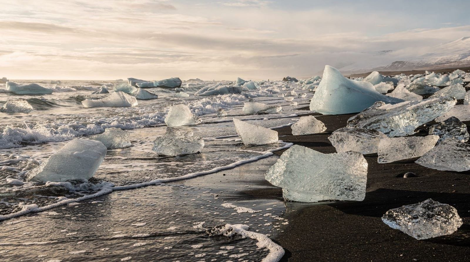
Day 2: Skaftafell glacier hike and Svartifoss in the morning, then drive east to Jökulsárlón and Diamond Beach in the afternoon, returning to Reykjavík or continuing east.
This is the sequence used in the south coast glaciers 4-day itinerary, which gives a more relaxed version with ice cave time and the Fjaðrárgljúfur canyon included.
Wildlife at Skaftafell
The Skaftafell woodland and surrounding moorland host a good range of species for Iceland — more varied than most South Coast stops because the habitat diversity is higher.
Reindeer: Introduced from Norway in the 18th century, wild reindeer are established in East Iceland and regularly seen in the Skaftafell area, particularly on the moorland east of the visitor centre and on the road toward Jökulsárlón. Evening is the best time; they tend to move toward lower ground and road verges late in the day.
Arctic foxes: Iceland’s only native land mammal. Present in the park year-round, though typically shy and more visible in winter when the landscape is less dense. The fox population is not hunted inside the park.
Ptarmigan: The Icelandic rock ptarmigan is present in large numbers on the moorland above Skaftafell. In winter, they turn completely white and are easy to spot against dark rocks; in summer, the brown camouflage is excellent. Common on the upper sections of the Skaftafell trail network.
Skua (great and Arctic): Present in summer on the moorland; known to dive-bomb hikers who approach nests too closely. Entirely normal behaviour — keep walking.
Snow bunting: Summer breeding visitor to the higher elevations; the bright white flash in flight is distinctive.
Wildlife-watching at Skaftafell is unstructured — no guided wildlife tours are available, and sightings depend on time, luck, and attentiveness. The morning hours and evening tend to be most productive.
The Skaftafell campsite: what to expect
Camping at Skaftafell is one of the better experiences available in the national park, primarily because of the setting — surrounded by birch woodland, with glacier views from the eastern edge of the camping area, and accessible trails directly from the site.
Facilities include flush toilets, showers (hot water, coin-operated at 200 ISK), a small shop selling basic camping supplies, and a washing-up area. Wi-Fi is available near the visitor centre but not at the campsite itself.
The campsite accommodates both tents and motorhomes. Pitch prices are approximately 1,800 ISK (€12) per person per night. In July and August, the campsite can hold 500+ people and fills completely most nights — advance booking is mandatory. The booking system opens in spring each year via the national park website.
The campsite’s main practical limitation is noise: adjacent to a major tourist site, with summer visitors arriving and departing at all hours, it is not a wilderness camping experience. It is comfortable and well-located, but not remote.
Frequently asked questions about Skaftafell
Is Skaftafell part of Vatnajökull National Park?
Yes. Skaftafell was an independent national park until 2008 when it merged with the larger Vatnajökull National Park, which now covers 14% of Iceland’s total area. The Skaftafell name continues to be used for the specific visitor area in the southern section of the park.
Can I walk on the glacier at Skaftafell without a guide?
No. The glacier surface (on Falljökull or any other tongue) is not safely accessible without crampons, a guide, and safety equipment. You can walk to the margin and view the glacier from a safe distance independently. Guided hikes depart from the visitor centre several times daily.
What is the Svartifoss waterfall known for?
Svartifoss is known for its perfectly formed hexagonal basalt columns that frame and surround the waterfall. The columns inspired several famous Icelandic buildings. The walk to it is about 45 minutes from the visitor centre.
Is the Skaftafell campsite good?
Yes — it is one of the most scenically located campsites in Iceland, inside the birch woodland with glacier views. Facilities include showers, toilets, and a small shop. Book in advance for July and August. Cost is approximately 1,800 ISK / €12 per person per night.
Is there parking at Skaftafell?
Yes — the car park adjacent to the visitor centre is large and free. In peak summer it can fill; arrive before 9am or after 6pm for easier parking.
How many km from Skaftafell to Jökulsárlón?
About 60 km east on Route 1, approximately 45 minutes driving without stops. The drive passes several small farms and the flat outwash plains (sandur) of Vatnajökull. Easy and scenic.
What is the easiest glacier hike at Skaftafell for beginners?
The guided hike on Falljökull (3 hours including approach walk) is designed for beginners. No prior experience is needed; the guide provides all equipment and teaches crampon use on site. The “easy” or “beginner” glacier hike options offered by local operators are specifically designed for first-timers.
Top experiences
Bookable activities with verified prices and instant confirmation on GetYourGuide.

Top-rated experiences in Skaftafell — glacier hikes and waterfalls in Vatnajökull NP
Best-rated activities across GetYourGuide and Viator.