Seljalandsfoss — the waterfall you can walk behind
Guide to Seljalandsfoss — walk-behind waterfall on Iceland's South Coast. Best time, trail conditions, parking fees, and the hidden Gljúfrabúi next door.
Seljalandsfoss: South Coast classic full day
Quick facts
- Best time
- May–Sep (path behind falls open); October–April can be icy/closed
- Days needed
- 1–2 hours including Gljúfrabúi
- Getting there
- ~1h 45min from Reykjavík (126 km east on Route 1, then Route 249)
- Budget per day
- ~900 ISK / €6 parking; combine with South Coast for 12,000–18,000 ISK / €80–120 total
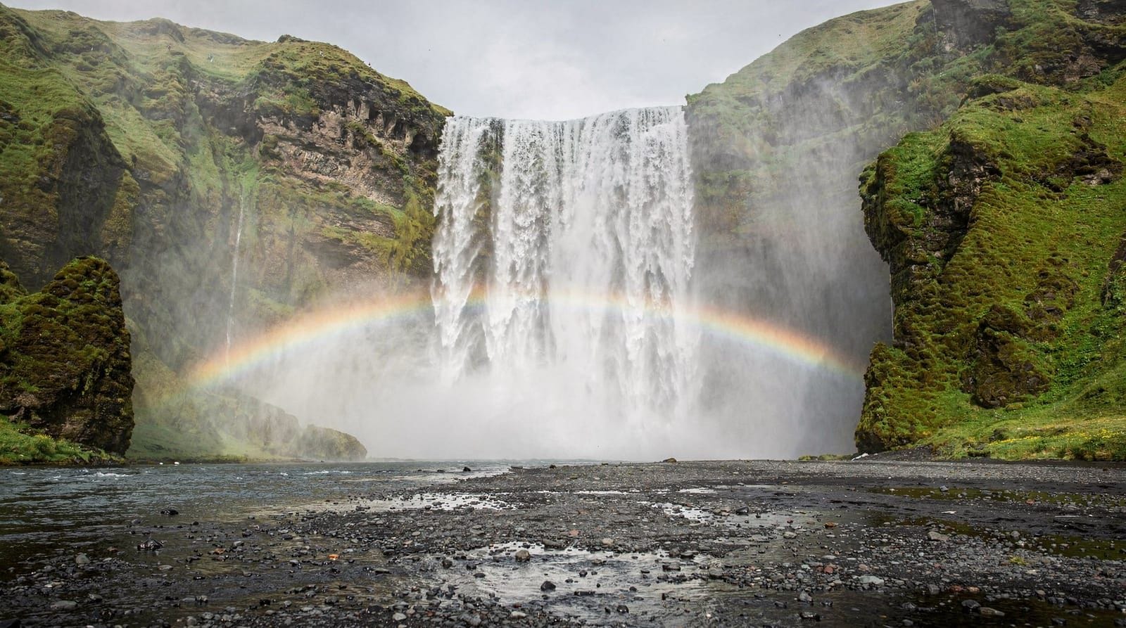
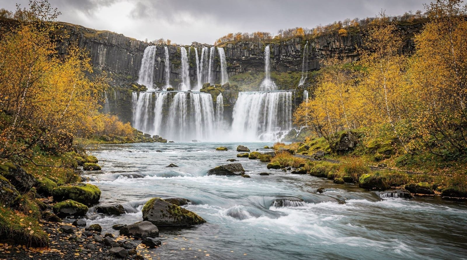
Seljalandsfoss drops 60 metres from the former sea-cliff edge that once marked Iceland’s coastline, and it is one of the very few waterfalls in the country where a maintained path leads directly behind the curtain of falling water. That walk-behind experience is the reason most visitors stop here — and it lives up to expectations, provided conditions are safe.
The falls sit on a small river called Seljalandsá, which drains off the slopes of Eyjafjallajökull. The parking area is clearly signed off Route 1 about 126 km east of Reykjavík, and there is a small charge to use the car park.
The behind-the-falls path
The circular path around Seljalandsfoss takes about 20–30 minutes to complete at a leisurely pace. The route crosses a bridge over the river, then circles the base of the cliff and passes through a narrow gap behind the waterfall itself, where you stand approximately 3–5 metres back from the falling water with the cliff wall behind you.
The experience is genuinely impressive: the roar is substantial, the spray soaks anything within range, and the view looking out through the white curtain towards the green Icelandic lowlands is one of the better natural photo opportunities on the whole South Coast route.
Equipment reality: You will get wet. The spray radius at the cave-like alcove behind the falls is considerable, and on windy days the mist can extend 20 metres from the falls. A waterproof jacket with a hood is essential. Lens cloths for cameras, a waterproof bag for electronics, and waterproof footwear are all worth the minor inconvenience of packing them. Half the visitors arriving in shorts and t-shirts in summer look regretful within three minutes.
Seasonal access: The path behind the falls is typically open from late April or May through October. In winter, the path ices over and becomes dangerous — operators have blocked access in past winters after falls. Check current conditions on safetravel.is if visiting between November and April. Some operators report the path being navigable with microspikes in winter but this is not the norm.
Gljúfrabúi — the hidden waterfall
About 500 metres north of the main Seljalandsfoss parking area, a small sign points to Gljúfrabúi (sometimes called Gljúfurárbúi). This waterfall is entirely hidden inside a narrow slot canyon, accessible by wading through a shallow stream — typically knee-deep at most, though depth varies with melt and rainfall.
Most visitors skip Gljúfrabúi because it is not visible from the road. This is unfortunate, because the interior of the canyon is remarkable: the waterfall plunges into a cathedral-like chamber sealed on all sides by smooth rock walls, with light filtering down from a crack above. The echo and the light are atmospheric in a way the main falls are not.
Accessing it: Bring waterproof footwear (the stream wading is unavoidable) or accept wet feet. The wade is 10–20 metres through the stream before the canyon opens up. The falls themselves are not behind-the-falls walkable, but you can stand on rocks inside the chamber and look up at the full drop. Total additional time from the main car park: 30–45 minutes.
Photography notes
Seljalandsfoss faces roughly south-west, which means the best light arrives in the evening in summer — from about 8pm to 10pm when the low sun illuminates the spray and the green hillside behind. Midday sun in summer creates flat, harsh light that washes out the detail in the water curtain.
For the behind-the-falls shot: most photographers set up at the right-hand side of the path (facing the falls from outside) where a slight elevation lets you frame the water curtain with the valley behind. A wide-angle lens at 16–24mm captures the full height; longer lenses compress the distance and miss the surroundings. The spray will fog your lens; bring multiple lens cloths and accept that you will need to wipe every 2–3 shots.
A graduated ND filter helps balance the bright water with the darker interior of the cliff alcove. Long exposures (1/2 to 2 seconds) smooth the water into a silky texture but require stability — the path behind the falls is narrow and slightly uneven.
Practical logistics
Parking: There is a fee car park (Seljalandsfoss parking, operated by the landowner). As of 2025, the fee is approximately 900 ISK / €6 per vehicle, payable by card at the machine. The car park fills quickly in summer — arrive before 9am or after 7pm on peak season days.
Toilets: Available at the car park (in the same building as a basic snack kiosk). The kiosk sells hot drinks and simple snacks at tourist prices; bring your own food if budget matters.
Facilities: Minimal. The site is a roadside stop, not a developed tourist centre. The nearest petrol station is in Hvolsvöllur (about 20 km west) or continuing east towards Vík.
Accessibility: The main viewpoint area (lower approach) is accessible on gravel path. The behind-the-falls circuit involves uneven, sometimes muddy terrain and is not suitable for wheelchairs or pushchairs with small wheels.
Eyjafjallajökull: the glacier above the falls
The Seljalandsá river drains off the Eyjafjallajökull glacier, meaning the water in Seljalandsfoss originates in one of Iceland’s most famous volcanic systems. The 2010 eruption of Eyjafjallajökull — the one that paralysed European air traffic for over a week — sent lava and ash from a summit vent about 20 km north of the waterfall.
The falls ran dark brown for several days after the April 2010 eruption as ash washed into the river system. This was not dangerous but was visibly different from the normal clear-to-milky white appearance of the falls. Visitors at the time captured photographs of ash-coloured Seljalandsfoss, a reminder that even famous landmarks look different under extraordinary geological circumstances.
The glacier above the falls is part of the ring road guide context — Eyjafjallajökull sits between Þórsmörk to the north and the South Coast below. The slopes visible from the Seljalandsfoss parking area on a clear day show the glaciated upper flanks and, in some conditions, steam from geothermal vents near the summit.
Combining Seljalandsfoss with the South Coast
Seljalandsfoss sits at the western end of the South Coast’s core sights. The standard self-drive order heading east from Reykjavík:
- Seljalandsfoss (1–2 hours including Gljúfrabúi)
- Skógafoss (30 minutes further east, 1–1.5 hours)
- Sólheimajökull glacier (additional 15 km east, 2–3 hours with guided hike)
- Reynisfjara and Vík (a further 20 km east)
This sequence works well as a long day from Reykjavík (10–12 hours total) or as the first morning of a two-day South Coast trip before continuing east toward Jökulsárlón.
South Coast classic full day — Seljalandsfoss, Skógafoss, black beach, and glacier in one guided tourThe geology behind the waterfall
Seljalandsfoss has its distinctive shape — a narrow curtain falling freely without a cliff face immediately behind it — because of the geology of the former sea cliff. About 10,000 years ago, when sea levels were higher and the land had not yet fully risen after glacial retreat, the ocean reached the base of the hills here. Wave erosion undercut the cliff face, leaving an overhang.
As the sea retreated (land uplift as glaciers melted), the undercut cliff remained. The Seljalandsá river, descending from Eyjafjallajökull, found this former sea-cliff edge and now pours over it as a free-falling curtain — with the hollow undercut behind creating the space for the famous path.
This geological accident — the combination of glacial retreat, sea-level change, and river drainage — is why walking behind Seljalandsfoss is possible when it is not possible at the larger Skógafoss 22 km east, which falls directly against its backing cliff.
The wider Seljaland area
The parking area for Seljalandsfoss is also the access point for several nearby stops that many visitors miss because they are not visible from the main falls:
Stakkholtsgjá canyon — about 15 km further up Route 249, a short walk leads to a dramatic slot canyon with a hidden waterfall at the end. The canyon walls close overhead, creating an enclosed atmosphere quite different from the open waterfall experience. The walk is about 45 minutes return and requires fording a shallow stream at the entrance. Total time from the main car park: 2 hours including driving.
Nauthúsagil ravine — a small but very photogenic moss-covered slot canyon about 7 km from Seljalandsfoss, reached on a 45-minute walk from a small roadside pull-off. The moss-covered walls of the ravine are a vivid green in summer, contrasting with the dark basalt. This site is rarely crowded.
Skógar Folk Museum — near Skógafoss to the east, this is worth combining with the waterfall visit. See the Skógafoss destination page for detail.
Tips for photographing Gljúfrabúi
Gljúfrabúi is more interesting photographically than Seljalandsfoss for photographers willing to get wet feet. The enclosed chamber creates a natural studio: diffuse light filters through the canyon crack above, the rock walls are covered in moss and lichen, and the falls are framed within a vertical slot.
A wide-angle lens (14–24mm) captures the full height of the chamber. The light inside is dim — significantly darker than outside — so a higher ISO (800–3200 depending on camera) or a tripod is necessary for sharp images. Long exposures (1/4 to 2 seconds) smooth the waterfall and reveal the texture of the walls.
The water at the base can be reflected in the still sections before the outflow — a second composition option that many visitors miss because they focus entirely on the falls and not the pool.
Exit the canyon carefully — the stream rocks are covered in algae and are extremely slippery. Poles help if you have them.
Getting to Seljalandsfoss
By car: Take Route 1 east from Reykjavík for approximately 120 km, then turn right onto Route 249 at the clearly marked sign for Seljalandsfoss. The car park is 2 km from the turnoff. The road is paved and accessible year-round; winter ice is possible on Route 249 between October and April.
Guided tour: Every South Coast day trip from Reykjavík stops at Seljalandsfoss. Typical allocated time is 45–60 minutes. The guide will generally mention Gljúfrabúi, but not all tours allocate time for it — ask specifically if you want to include it.
Public bus: Strætó’s Route 51 runs between Reykjavík and Höfn and stops near Seljalandsfoss (at the Route 1 junction), but the stop is several kilometres from the car park and there are no taxis locally. Public transport does not work for this stop in practice.
Frequently asked questions about Seljalandsfoss
Can you walk behind Seljalandsfoss?
Yes — that is the main draw. A maintained path circles the base of the waterfall and passes through a narrow gap in the cliff directly behind the falling water. The path is open roughly from May to October when conditions allow. In winter it can be closed due to ice.
How wet do you get behind Seljalandsfoss?
Very wet, especially in wind. The spray from the falls extends several metres into the alcove behind. A fully waterproof jacket and hood are not optional — they are necessary. Camera equipment should be in a waterproof bag when not actively shooting.
Is there a fee to visit Seljalandsfoss?
There is no entrance fee to see the waterfall. There is a parking fee of approximately 900 ISK / €6 per vehicle, payable by card at the machine in the car park. You can park on the roadside for free but this is inconvenient and may be unsafe on busy days.
What is Gljúfrabúi and how do I find it?
Gljúfrabúi is a second waterfall hidden inside a slot canyon about 500 metres north of the main Seljalandsfoss car park. You reach it by following the path north from the car park and then wading through a shallow stream into the canyon. It is worth the wet feet — the interior chamber is genuinely atmospheric and far less crowded than the main falls.
How long does it take to visit Seljalandsfoss?
The main loop around and behind the falls takes 20–30 minutes. Adding Gljúfrabúi brings the total to about 60–75 minutes. Allow 15 minutes for parking and walking from the car.
What time should I visit to avoid crowds?
Before 8:30am or after 7pm in peak season (June–August). Tour buses start arriving around 10am and the site is at its most crowded between 11am and 4pm. The evening light (8–10pm in summer) is also better for photography than midday sun.
Is Seljalandsfoss suitable for children?
The main viewing area and the lower part of the circuit path are manageable for most children old enough to walk independently on uneven terrain. The behind-the-falls section requires good footwear and the ability to stay on a narrow path. Young children should be supervised closely, particularly near the base of the falls where the ground is slippery and the water spray is heavy.
Top experiences
Bookable activities with verified prices and instant confirmation on GetYourGuide.
Top-rated experiences in Seljalandsfoss — the waterfall you can walk behind
Best-rated activities across GetYourGuide and Viator.