Landmannalaugar hiking guide — trails, hot springs, and highland logistics
Reykjavik: Landmannalaugar pearl of the Highlands
What is Landmannalaugar and why do hikers go there?
Landmannalaugar is a highland area in the Fjallabak Nature Reserve, about 180 km from Reykjavík. It is the northern trailhead of the Laugavegur trek and a destination in its own right for its geothermal hot springs, multicoloured rhyolite mountains, and obsidian lava fields. The landscape is unlike anywhere else in Iceland.
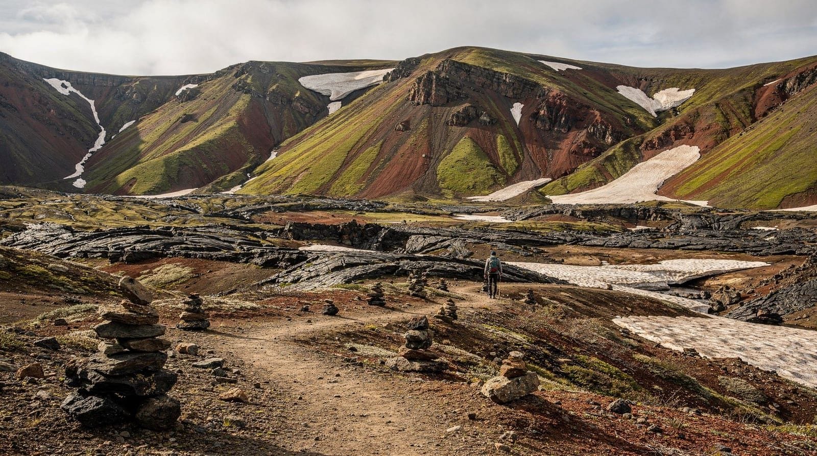
Landmannalaugar sits in the interior of Iceland at 600 m elevation, surrounded by rhyolite mountains in colours that should not exist in nature — sulphur yellow, ochre, sage green, chocolate brown, and vivid magenta arranged in bands across hillsides that look like geological cake layers. A geothermal hot spring flows from beneath a lava field into a cold river, creating a natural bathing pool. From here, the Laugavegur trail sets out across 55 km of highland terrain toward Þórsmörk.
It is a genuinely remote place. Getting there requires either a long drive on F-roads or a highland bus journey that costs money and requires planning. For hikers willing to do that work, few highland bases in Iceland offer the same combination of day-hike options, natural bathing, and access to the country’s most famous multi-day trail.
What makes Landmannalaugar’s landscape distinctive
The colours come from rhyolite, a silica-rich volcanic rock that erupts at lower temperatures than Iceland’s dominant basalt. Where basalt lava fields are dark grey or black, rhyolite outcrops oxidise to orange, rust, green, and yellow. The Fjallabak area has the largest concentration of rhyolite mountains in Iceland.
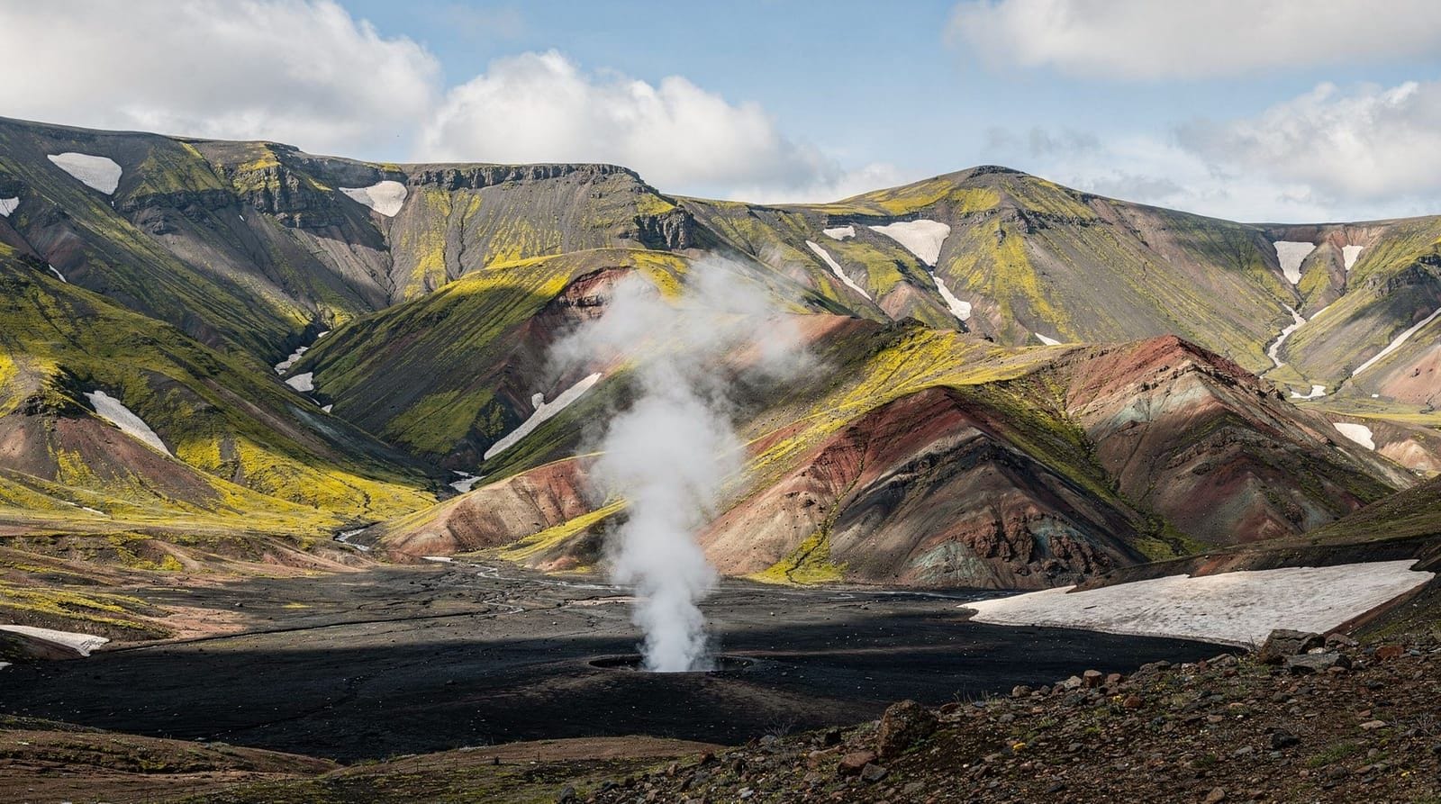
The area also has active geothermal heat beneath the surface, which drives the hot spring and creates occasional steam vents. The Laugahraun lava field — a relatively recent eruption from around 1477 CE — pushed a large obsidian flow up to the edge of the existing hot spring.
The best day hikes
Brennisteinsalda loop (4 km, 2–2.5 hours). This circuit of the Brennisteinsalda volcano is the most accessible good hike at Landmannalaugar. The name means “sulphur wave” and refers to the vivid colouring on the hill’s flanks. The trail passes through geothermal steam vents, across patches of snow (until late July), and along ridges with views over the entire basin. The descent returns through the hot spring area. Suitable for most fitness levels.
Bláhnúkur summit (7 km, 3.5–4.5 hours). Bláhnúkur (“Blue Peak”) rises to 943 m above the Landmannalaugar valley and gives the best panoramic view of the area. The name comes from the blue-grey obsidian rock that makes up much of the slope. The ascent is steep but clearly marked. On a clear day the view extends to Hekla volcano, the Mýrdalsjökull icecap, and the coastal plains 80 km away. Moderate fitness required.
Laugahraun lava field walk (2–3 km, 1–2 hours, flat). A flat walking path threads through the 1477 lava field, which produced some of Iceland’s most accessible obsidian. The dark, glassy rock stands in complete contrast to the colourful rhyolite around it. Good for families or those who want a shorter walk without significant elevation gain.
Ljótipollur (13 km round trip, 5–6 hours). A longer day hike follows the Laugavegur trail northeast to the explosion crater Ljótipollur (“Ugly Puddle”) — a red crater lake that is anything but ugly. The trail also passes another crater, Norðurnámur, and traverses some of the most vivid rhyolite terrain on the entire network. Requires good fitness and navigation; carry a map.
Getting to Landmannalaugar
By highland bus. Reykjavík Excursions and Trex both run scheduled buses from Reykjavík to Landmannalaugar. Buses depart Reykjavík BSÍ bus terminal and take approximately 3.5–4 hours, following Route 1 south before turning onto F26 and F208. Current (2026) one-way fare is approximately ISK 9,000–12,000 (EUR 58–78). Seat reservation is required and early booking is strongly advised for July dates.
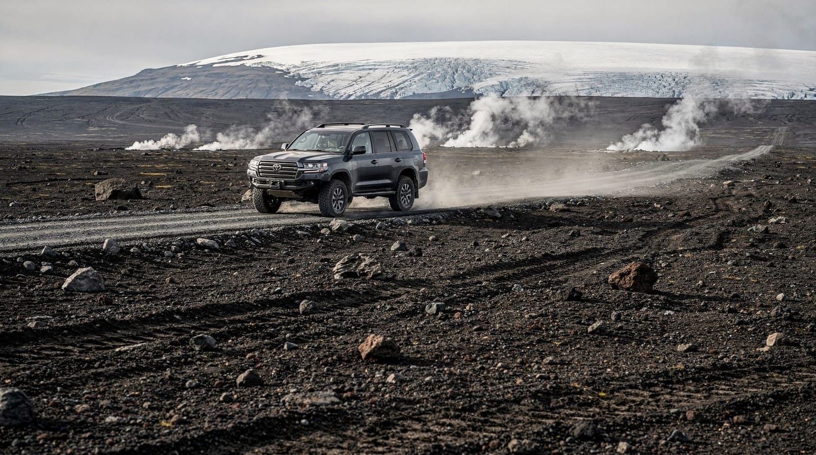
By 4WD vehicle. The primary route from Reykjavík uses Route 1 to Hella, then F26 and F208 north. The F-roads require a true 4WD with high clearance — the Tungnaá river crossing on F26 and the final approach on F208 have water depth that can reach 50 cm. A standard 4WD hire car (Dacia Duster, Toyota RAV4) manages this in normal conditions; a super-jeep is safer after heavy rain. Check F-roads Iceland before driving. Journey time from Reykjavík: 3–3.5 hours.
There is also an eastern approach via F208 from the Þórsmörk direction, and a southern approach via F225, but the F26/F208 from Hella is the most commonly used.
If you want the experience without driving F-roads yourself, a super-jeep day tour from Reykjavík handles all the highland driving, includes a guided hike into the rhyolite hills, and returns you to the city in the evening.
Accommodation at the Landmannalaugar hut
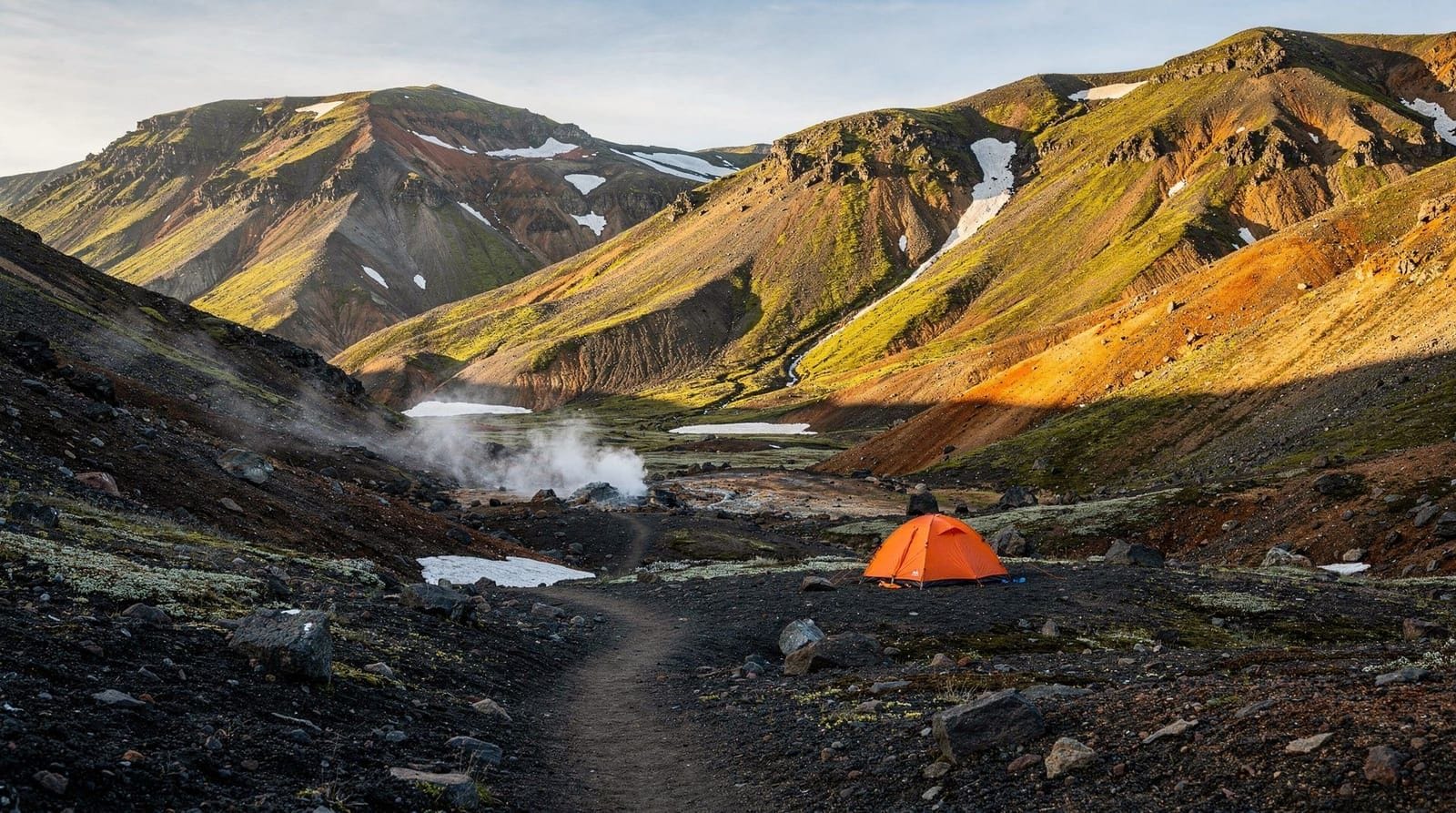
The FÍ hut at Landmannalaugar offers sleeping-bag accommodation in dormitory bunks. Current pricing is approximately ISK 14,000–17,000 (EUR 90–110) per person per night in the hut, or ISK 3,500–5,000 (EUR 22–32) per person per night camping. The hut includes a communal kitchen with gas stoves (bring your own food), a drying room, flush toilets, and paid showers (ISK 800–1,000).
Bookings open at fi.is in January for the coming summer season. July hut beds sell out; camping spots remain available longer but book these too if you want a guaranteed pitch.
The campsite has a large flat area beside the hot spring. Pitches are first-come, first-served until full. Expect significant noise from late arrivals and early risers in summer.
The hot spring pool
The main geothermal feature at Landmannalaugar is a mixing zone where hot water (emerging at around 50–60°C from the ground) meets the cold Nyrðri-Ófæra river. In the overlap zone — roughly the size of a large swimming pool — the temperature sits around 36–42°C depending on your position. Closer to the inlet = hotter; closer to the river = cooler.
There are no facilities: no changing rooms, no lockers. Hikers change by the riverbank. The pool is free to use. In high season (July), the pool reaches capacity around midday and remains busy until early evening. Early morning (before 09:00) or late evening bathing offers much more space.
Note: the water is not treated. Avoid submerging your head.
Landmannalaugar and the Laugavegur trail
Landmannalaugar is the northern trailhead of the Laugavegur trek, Iceland’s most famous multi-day hike. The 55 km route to Þórsmörk begins here and passes through the huts at Hrafntinnusker, Álftavatn, and Emstrur over four days. Hikers doing the full trek typically arrive at Landmannalaugar the afternoon before Day 1 to acclimatise and collect equipment.
If you are not doing the Laugavegur, you can still walk the first section of the trail from Landmannalaugar and return the same day — the initial 12 km to Hrafntinnusker is one of the most dramatic trail sections in Iceland and can be walked as a long day hike with a return on the same route.
A guided day hike from Reykjavík takes you to Landmannalaugar for a 4-hour hiking experience through the coloured hills, with return transport included.
What to expect on the ground
The Landmannalaugar area receives significant foot traffic in summer. Some practical realities:
- Parking at the main site is on gravel and can be full by 11:00 on July weekends.
- There is a small food kiosk selling soup, hot drinks, and basic snacks. It is expensive and limited — bring your own food.
- Mobile signal is intermittent; some providers have coverage near the hut, others do not.
- The nearest fuel station is in Hella, about 90 minutes away — fill up before driving in.
- Rubbish disposal is available at the hut; pack out everything you carry in.
Frequently asked questions about Landmannalaugar hiking
How many days should I spend at Landmannalaugar?
One overnight stay allows a full evening and morning of hiking, plus the hot spring. Two nights lets you complete both the Brennisteinsalda loop and the Bláhnúkur summit without rushing. Three days is comfortable if you want to include the Ljótipollur crater and the start of the Laugavegur.
Is Landmannalaugar suitable for children?
The flat lava field walk and the lower section of the Brennisteinsalda loop are manageable for children over 7. Bláhnúkur and the longer hikes involve sustained steep terrain unsuitable for young children. The hot spring is family-friendly but the water temperature varies; supervise children closely.
Can I see the northern lights from Landmannalaugar?
In theory, yes — the altitude and remoteness from light pollution make it an excellent dark-sky location. However, the highland season runs June to September, when Iceland has midnight sun or near-24-hour daylight. The northern lights are not visible during this period. Landmannalaugar is inaccessible in winter when the aurora is active.
What happens if the F-roads close while I’m there?
Road closures due to flooding or storm are relatively rare in summer but do occur. The hut warden will have the most up-to-date information. In a prolonged closure, highland buses may be delayed or cancelled. Having 2–3 extra days of food and flexibility in your schedule is sensible for any highland trip.
Are there bears, snakes, or dangerous animals in the Fjallabak area?
No. Iceland has no land predators, no snakes, and no dangerous terrestrial wildlife. The main safety risks are weather, river crossings, and cold temperatures — not fauna.
How far is Landmannalaugar from Hekla volcano?
Hekla is approximately 50 km northwest of Landmannalaugar. It is visible on clear days from the summit of Bláhnúkur. Hekla is one of Iceland’s most active volcanoes; eruption monitoring information is available at vedur.is.
The geology of the Fjallabak area
Understanding why Landmannalaugar looks the way it does makes the experience significantly richer. The Fjallabak Nature Reserve (Fjallabak means “behind the mountains”) sits at the boundary between the volcanic lowlands of south Iceland and the central highland plateau, where two different volcanic systems interact.
Basalt — Iceland’s dominant volcanic rock — erupts at around 1,000–1,200°C and produces dark, fluid lava that flows easily and cools to the black rock that characterises most of Iceland’s landscape. Rhyolite erupts at lower temperatures (around 700–900°C) from magma that has been processed and enriched in silica, usually after sitting in a magma chamber for longer. The silica makes it viscous; rhyolite eruptions tend to be more explosive and produce the distinctive colouring from iron and mineral oxidation.
The Fjallabak area has the largest concentration of exposed rhyolite in Iceland, produced by the Torfajökull central volcano — Iceland’s largest rhyolite volcanic system. The multicoloured ridges around Landmannalaugar are the eroded remnants of Torfajökull’s erupted material from multiple eruption cycles over thousands of years.
The Laugahraun lava field, which partially buries the Landmannalaugar hot spring, was erupted around 1477 CE from a fissure within the Torfajökull system. It is one of Iceland’s youngest lava flows and consists of obsidian — volcanic glass formed when rhyolite lava cools very rapidly, producing a dark, glassy rock.
The geothermal heat that drives the hot spring comes from the same system — groundwater circulating through fractured rock near the magma chamber absorbs heat and rises back to the surface.
What other hikers report
Visitor accounts from recent summers point to a few consistent patterns worth knowing:
The most common surprise: the altitude gain on Bláhnúkur is steeper than most people expect from a 7 km return hike. The upper third of the slope is loose obsidian scree where footsteps slide backward. Allow extra time and consider trekking poles.
The most underrated hike: the Ljótipollur crater day hike is significantly less crowded than Bláhnúkur and equally impressive in its own way. The red crater lake is striking and the route takes you deeper into genuine highland terrain away from the Landmannalaugar base camp crowd.
The hot spring timing: arriving at the hot spring after 18:00 in July dramatically improves the experience. The day tour buses have departed, the Reykjavík day-tripper traffic has thinned, and the mountain light in late evening is often better for the surrounding rhyolite colours.
The biggest mistake: not bringing warm enough clothing for the evenings. Temperatures at Landmannalaugar drop to 5–8°C after sunset even in July. People who arrive for a day hike without a proper insulating layer find the post-hike cooling uncomfortable.
Landmannalaugar compared to similar Highland destinations
The Highlands of Iceland offer several distinct environments:
Landmannalaugar vs Kerlingarfjöll: both are rhyolite-dominant highland areas with geothermal activity. Landmannalaugar is the more famous and more visited. Kerlingarfjöll has a staffed resort with better facilities and is accessible earlier in the season on the F35 Kjölur route. See the Askja and Kerlingarfjöll guide for comparison.
Landmannalaugar vs Askja: completely different environments. Askja is a dark, austere caldera in the northeast highlands. Landmannalaugar is colourful, geothermally active, and with better infrastructure. Both require F-road access.
Landmannalaugar vs the Þórsmörk valley: Þórsmörk is the destination at the end of the Laugavegur trail — green, birch-forested, sheltered, and warm. Landmannalaugar is cold, exposed, and volcanic. They are complementary rather than comparable.
Self-guided vs guided visits
Most visitors to Landmannalaugar arrive independently by highland bus or 4WD. Guided tours to Landmannalaugar are available from Reykjavík and typically include:
- Transport from Reykjavík by highland bus or super-jeep
- A guided 3–5 hour hike (usually the Brennisteinsalda loop or a segment of the Laugavegur)
- Time for the hot spring
- Return transport
The advantage of a guided day visit: no F-road driving, no booking uncertainty, geological and historical commentary. The disadvantage: you are on a fixed schedule with a group, typically 10–20 people.
Independent visits give more flexibility to hike at your own pace, stay longer in the hot spring, and take the Bláhnúkur summit at a speed that suits your fitness. For anyone comfortable with highland bus logistics, the independent option is usually more satisfying.
Emergency information
The hut warden at Landmannalaugar is the first point of contact for any emergency. The hut has radio communication with the ICE-SAR rescue coordination centre. Emergency number: 112. Register your hiking plan at safetravel.is before any hike from the Landmannalaugar base. The Veðurstofa (Icelandic Meteorological Office) highland forecast is at vedur.is.
What to do with a full week based at Landmannalaugar
Hikers spending 4–7 days based at Landmannalaugar (not starting the Laugavegur) have more options than most travel guides acknowledge:
Day 1: Arrive, bathe in the hot spring (late afternoon, after the tour groups leave), explore the Laugahraun lava field flat walk. Light orientation.
Day 2: Brennisteinsalda circuit. Full 4 km loop with steam vents and the best colour views. Return for evening bathing.
Day 3: Bláhnúkur summit (7 km, 4–5 hours). The best panoramic views in the area. Pack a warm layer for the exposed summit.
Day 4: Ljótipollur crater day hike (13 km, 5–6 hours). Deepest into the Fjallabak highland terrain. The red crater lake is the reward.
Day 5: Walk the first 12 km of the Laugavegur to Hrafntinnusker and return the same route. This is a legitimate 24 km day hike and gives you the full first-day Laugavegur experience without the commitment to the full trek.
Day 6: Rest day. The hot spring in morning and afternoon. Explore the valley above the campsite on a short walk.
Day 7: Return via highland bus.
This schedule requires 4 nights at the hut (book well in advance) or tent camping for the full stay. It covers the major day hiking options thoroughly and provides multiple days of hot spring access.
The Landmannalaugar area for photographers specifically
Beyond the headline rhyolite colour photography, several less-photographed subjects in the area:
The obsidian detail: close-focus photography of obsidian at the Laugahraun field edge reveals extraordinary detail — the glass-like fracture surfaces, colour variations from pure black to dark red where iron content varies, and the bubble structures from rapidly cooling lava. Best photographed in diffuse cloudy light that eliminates surface glare.
Hot spring algae: the orange, yellow, and green algae mats in the geothermally heated stream channels are vivid and abstract. Macro photography in the 50–100 mm range with a polarising filter to cut water reflections produces images that do not obviously read as Iceland.
Steam tent photography: shooting through or across the steam vents near the hot spring in cool morning air, with the rhyolite hills as background, produces atmospheric images that are under-represented in Landmannalaugar photography.
Evening light on Brennisteinsalda: the sulphur yellow and green slopes catch sunset light in the northwest in summer, creating a warm tonal range that contrasts with the blue-grey obsidian visible in the Laugahraun below. Best in late July when the sun is lower by midnight.
The Laugavegur ultra and competitive events
The Landmannalaugar to Þórsmörk route has a competitive running event — the Laugavegur Ultra Marathon — held annually in July. The race covers the full 55 km with approximately 2,000 m of total elevation gain/loss, and elite runners complete the course in approximately 5–6 hours. The event is over-subscribed each year and entries are allocated by lottery months in advance.
For recreational hikers, the ultra race gives a useful reference for what is possible on the trail in good conditions. The 4-day walking schedule at an unhurried pace is appropriate for most visitors; fit trail runners can walk the full route in 2 days.
The existence of the race also means that in mid-July, there are periods of intense trail traffic as runners and their support crews use the same buses and huts as recreational hikers. If you are hiking during race week, check the specific date (usually third weekend in July) and either align with it for the atmosphere or avoid it for quieter conditions.
Frequently asked questions about Landmannalaugar hiking guide
When is Landmannalaugar accessible?
The F-roads open roughly mid-June to early October, depending on snow and river levels. The highland bus services from Reykjavík begin late June and run to early September. Attempting the roads in May risks getting stuck in snowdrifts.Can I reach Landmannalaugar without a 4WD?
No. The access roads — primarily F26 and F208 — are classified F-roads, legally off-limits to standard 2WD hire cars. River crossings on the route require a vehicle with high clearance and 4WD. Using a standard car risks vehicle damage and your hire contract will be void.Is there accommodation at Landmannalaugar?
The FÍ (Icelandic Touring Association) operates a hut with sleeping-bag accommodation (book at fi.is) and a large camping area. There are no hotel-style rooms. The hut includes a basic kitchen, drying room, and toilets. Camping costs around ISK 3,500–5,000 per person per night.Can I swim in the hot spring at Landmannalaugar?
Yes. The natural hot spring flows directly into a cool river, creating a mixing zone of comfortable bathing temperature (roughly 36–42°C depending on where you sit). There are no facilities — bring a towel, change discreetly, and expect company in summer.What are the best day hikes from Landmannalaugar?
The Brennisteinsalda loop (4 km, 2 hours) is the most popular — it circles one of the most colourful volcanoes in the area. The Bláhnúkur hike (7 km, 3–4 hours) reaches a dramatic blue-black peak with views across the entire highland. The Laugahraun lava field walk (flat, 1–2 hours) explores the obsidian flows without significant climbing.How do highland buses work for Landmannalaugar?
Reykjavík Excursions (re.is) and Trex run scheduled highland buses from Reykjavík BSÍ terminal. Journey time is 3.5–4 hours. Buses can drop you at Landmannalaugar for a day visit or overnight stay; return tickets are separate. Book in advance — July buses fill quickly.Is Landmannalaugar overcrowded?
In July, yes — the campsite can hold 600+ tents and the hot spring pool gets very busy between 10:00 and 16:00. Arriving by early-morning bus or staying overnight to hike before 09:00 avoids the worst crowds. Weekdays in August are significantly quieter than weekends.
Top experiences
Bookable activities with verified prices and instant confirmation on GetYourGuide.

Top experiences
Best-rated activities across GetYourGuide and Viator.

Sólheimajökull Glacier Hike – Adventure in a Small Group
- Viator

Blue Ice Discovery – Guided Glacier Hike from Skaftafell
- Viator

Glacier Hike from Skaftafell - Extra Small Group
- Viator

Sólheimajökull Glacier Hike - Small Group Blue Ice Adventure
- Viator

Skaftafell Glacier Hike 3-Hour Small Group Tour
- Viator

Solheimajokull Glacier 3-Hour Small-Group Hike
- Viator