Askja and Kerlingarfjöll — Iceland's remote highland calderas and hot spring mountains
Iceland: Reykjavik kerlingarfjoll private jeep and hiking day tour
How do I visit Askja and Kerlingarfjöll, and can I do both in one trip?
Both destinations are in Iceland's interior highlands, accessible by F-road only. Askja is 220 km from Akureyri via F88; Kerlingarfjöll is 90 km from Route 1 via F35 (Kjölur route). They are about 150 km apart by highland road — most visitors choose one or combine them over 2–3 days in the interior.
Two of Iceland’s most compelling highland destinations sit in the remote interior, separated by roughly 150 km of F-road and requiring days of planning to visit safely. Askja is a massive caldera complex with an extraordinary history — the 1875 eruption was catastrophic enough to drive mass emigration from northeast Iceland to Canada. Kerlingarfjöll is a cluster of rhyolite peaks with geothermal fields that colour the mountainsides in orange, yellow, and rust, with natural hot pools scattered through the terrain.
Neither is easy to reach. Both reward the effort with landscapes that genuinely have no equivalent elsewhere in Iceland — or in most of Europe.
Askja: the caldera and Víti crater
Askja is a central volcano in the Dyngjufjöll mountain range in the northeast highlands, about 220 km from Akureyri by road. The main caldera (Öskjuvatn lake) formed through subsidence after a prehistoric eruption and now holds Iceland’s deepest lake at 220 m depth. The caldera itself is approximately 8 km across.
The 1875 eruption — which covered much of northeast Iceland in tephra and forced thousands of farmers to abandon their land — created the smaller Víti explosion crater on the northeast edge of the caldera. Víti (meaning “hell”) holds a shallow lake of geothermally heated water, currently around 20–24°C.
What to hike at Askja:
The main walking route from the Dreki hut parking area to Víti and the caldera edge is approximately 5 km return, with minimal elevation gain on the flat caldera floor. The caldera rim itself involves some scrambling and gives views over the full extent of the Öskjuvatn lake. Allow 2–3 hours for the walk plus time to descend to Víti.
A longer option continues east along the caldera rim to the viewpoint above the main lake — around 8–10 km return and more demanding in terms of rough terrain. Good boots essential.
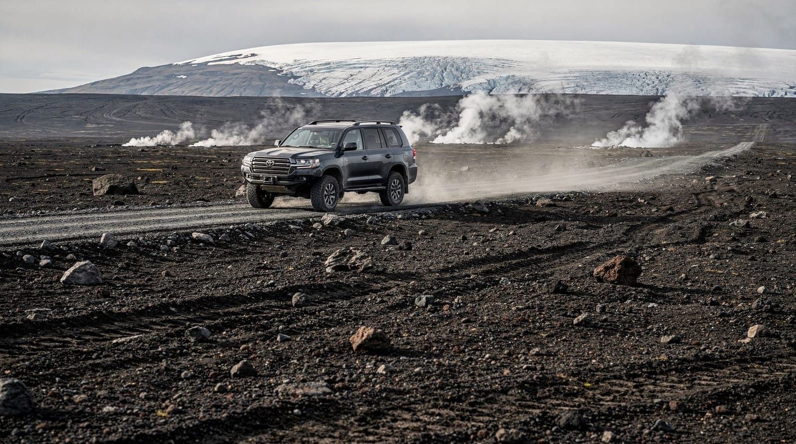
A super-jeep wilderness tour from Lake Mývatn to Askja takes approximately 12 hours and handles the F88 river crossings professionally — by far the safest way to visit Askja if you are not confident driving the F-roads yourself.
Getting to Askja independently:
The most common approach is via F88 from Route 1 near Lake Mývatn, heading south through the Möðrudalur plain and crossing several rivers. The Lindaá river on F88 is one of Iceland’s more demanding unbridged crossings — depth ranges from 30 cm to 80 cm depending on conditions and time of day. Cross in the early morning when overnight cold has reduced glacial meltwater.
Alternative approach: F910 from the east, which adds length but some crossings are more consistent. Most guided tours use F88 from the north.
Journey time from Mývatn to Askja: 2.5–3 hours each way. From Akureyri: 3.5–4 hours each way.
What the 1875 eruption did:
The VEI-5 eruption on 28 March 1875 deposited a thick layer of ash and pumice across a wide area of northeast Iceland, destroying farmland and making continued agriculture impossible for thousands of families. An estimated 2,500 people emigrated from northeast Iceland to Canada (mainly Manitoba) in 1875–1880 as a direct result. The event shaped the regional culture and the sizeable Icelandic-Canadian community in Gimli, Manitoba.
Geologically, the eruption created the Víti crater and expanded the existing caldera substantially. Smaller eruptions occurred in 1920 and 1961; the volcano is considered active.
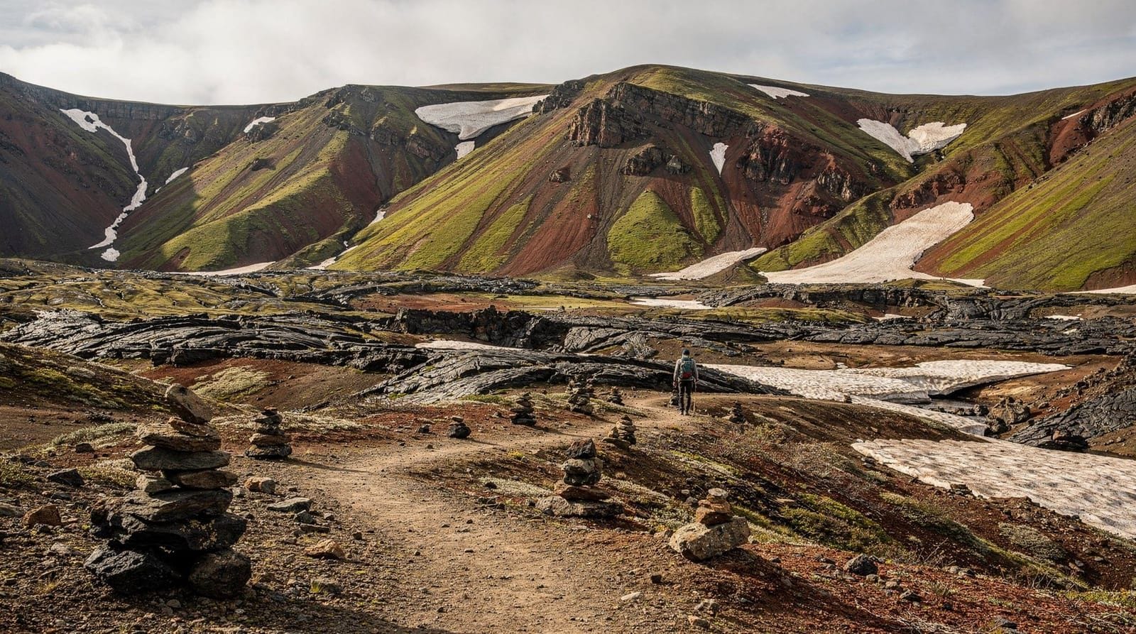
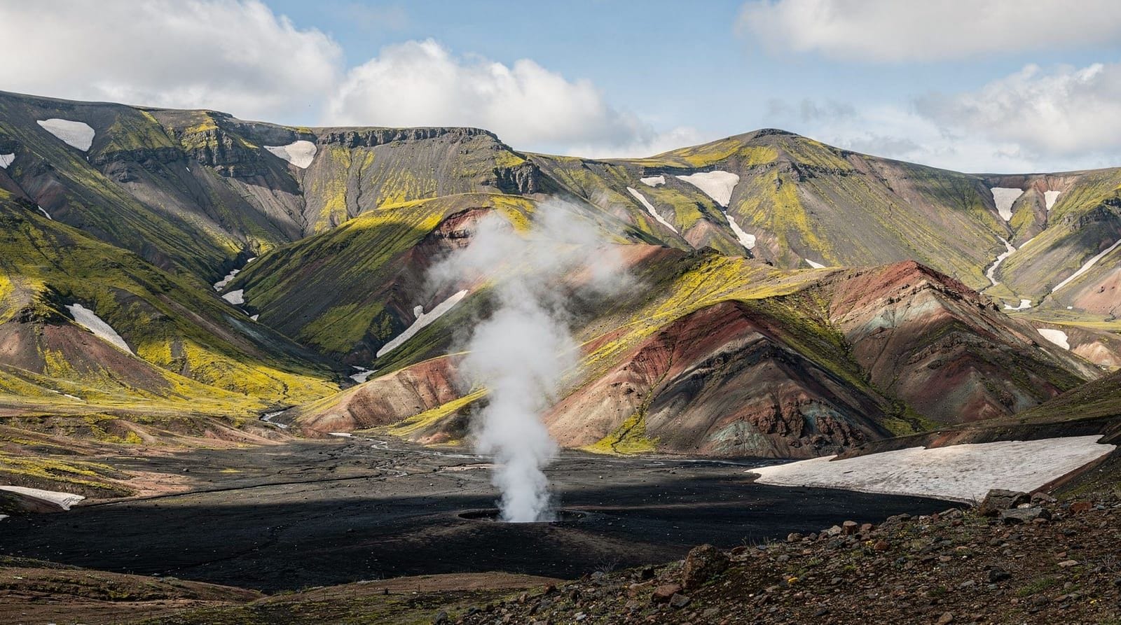
Kerlingarfjöll: the rhyolite highlands
Kerlingarfjöll sits roughly in the centre of Iceland, 90 km south of the Ring Road via the F35 Kjölur route. The mountain complex consists of several rhyolite peaks, the highest reaching 1,477 m, surrounded by active geothermal fields where boiling mud pools, steam vents, and orange mineral deposits mark the surface.
The area feels dramatically different from Askja — where Askja is dark, vast, and austere, Kerlingarfjöll is colourful, concentrated, and accessible from the resort base camp.
What to hike at Kerlingarfjöll:
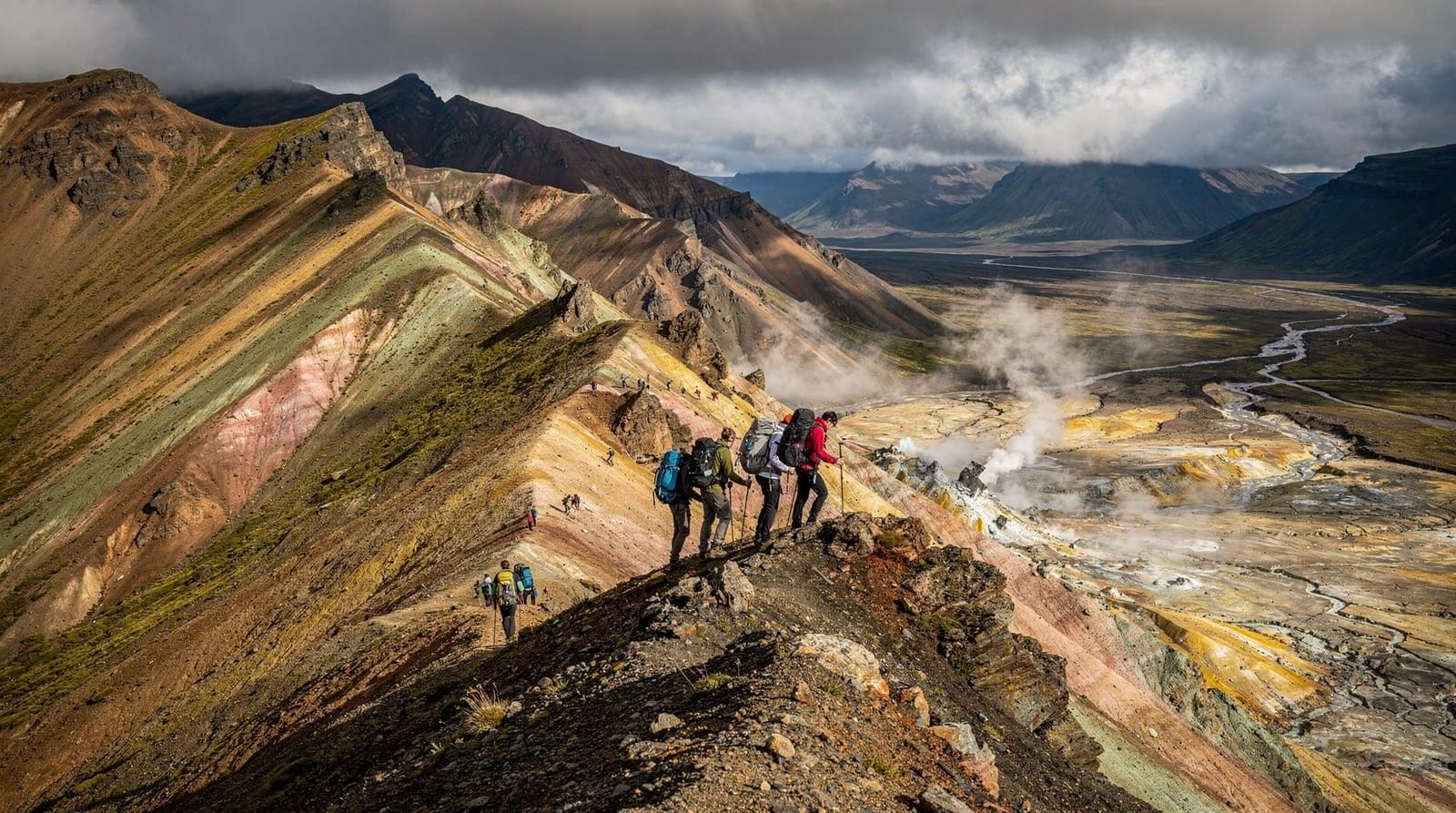
The Hveradalir geothermal valley (2 km from the resort, 1.5 hours return) is the most popular short hike — it leads through rhyolite gullies to the most active geothermal zone, with vivid orange iron oxide deposits and significant steam activity. This trail is suitable for most fitness levels; the ground around the active vents is fragile and you must stay on the marked path.
A longer ridge circuit covers the full Kerlingarfjöll massif over 7–9 km (4–5 hours) and reaches viewpoints with views over the surrounding highland plateau toward the Hofsjökull icecap. Some scrambling on the upper section.
Kerlingarfjöll Highland Baths:
The Kerlingarfjöll resort operates heated pools using geothermal water at a commercially maintained bathing facility. Current entry price is approximately ISK 4,500–5,500 (EUR 29–36). This is not a wild bathing experience — it is a simple pool complex in a dramatic highland setting. Different from the wild Reykjadalur experience; both have value.
The Kerlingarfjöll Highland Baths offer geothermal bathing at altitude with dramatic mountain views — bookable separately from any accommodation at the resort.
Getting to Kerlingarfjöll:
Via F35 (Kjölur route) from Route 1, which runs south of Blönduós on the north or from the Golden Circle area (Gullfoss) in the south. The F35 is one of the better-maintained highland roads in Iceland and crosses the Kerlingará river, which is generally manageable for competent 4WD drivers. Journey time from Gullfoss: 1.5 hours. From Blönduós: 2 hours.
A private jeep tour from Reykjavík covers Kerlingarfjöll as a full-day trip (10–12 hours).
A private jeep day tour from Reykjavík includes transport on the Kjölur route, guided hiking in the geothermal valley, and return by late evening — the most flexible way to visit Kerlingarfjöll from the capital.
Askja vs Kerlingarfjöll: which to prioritise
The choice depends significantly on where you are based and what you want from a highland visit.
Choose Askja if: you are based in Akureyri or North Iceland, you want a dramatic volcanic caldera experience, you are interested in Icelandic geological and historical significance, you have time for a full-day return trip with reliable guided transport.
Choose Kerlingarfjöll if: you are based in Reykjavík and doing a Golden Circle or Ring Road circuit, you want accessible geothermal colour without the challenging F88 river crossings, you want accommodation and the Highland Baths in one location.
Both: if you have 4–5 days in the interior and a suitable vehicle. The F35 and F88/F910 can be linked via highland tracks on a multi-day 4WD trip, though this requires real expedition-level preparation.
What to know before going to either destination
Fuel: the nearest petrol station to Askja is at Möðrudalur (F-road side) or the Mývatn area. There are no fuel supplies in the interior. Calculate your fuel requirement carefully and carry extra if possible. Kerlingarfjöll has no fuel — fill up in Reykjavík, Selfoss, or Blönduós.
Communication: mobile coverage is absent throughout the interior. Satellite communication device strongly recommended. Register your travel plan at safetravel.is.
Weather: interior highland weather can deteriorate very rapidly. A clear morning at the Ring Road does not guarantee conditions at 700–900 m elevation in the interior. Check vedur.is specifically for the highland forecast.
Vehicle requirements: A real 4WD with high clearance (not just AWD or a crossover) is required. For Askja via F88, a super-jeep or medium expedition vehicle is significantly safer than a standard 4WD hire car. Rental companies in Iceland have specific lists of vehicles permitted on F-roads — check yours before driving.
Frequently asked questions about Askja and Kerlingarfjöll
Can I visit both Askja and Kerlingarfjöll in one day?
Not comfortably from Reykjavík. The driving distances involved (300+ km on F-roads) make a single-day visit to both nearly impossible while leaving meaningful time at either destination. Plan separate days or an overnight stay in the interior.
Is the Víti crater safe to visit after past incidents?
Swimming in Víti is currently permitted (2026) with appropriate caution. The 2014 disappearance in the crater led to a 5-year closure. The access path remains steep and loose. Children should not descend to the water. Check current status at ust.is.
What is the elevation at Askja and Kerlingarfjöll?
The Askja caldera sits at approximately 1,000–1,100 m. Kerlingarfjöll peaks reach 1,477 m with the resort base at around 650–700 m. Both experience highland weather conditions with cold temperatures and rapid weather change.
Are there marked hiking trails or do I need a guide?
Kerlingarfjöll has marked trails from the resort. Askja has basic marked routes from the Dreki parking area. Both are technically walkable without a guide in good conditions. However, the F-road drives to reach them benefit significantly from guided expertise, particularly at Askja.
Can I see northern lights from these destinations?
In theory, the interior location and absence of light pollution make both ideal aurora viewing spots. However, highland access in the aurora season (September to April) is extremely restricted — most F-roads are closed by October and Askja is inaccessible in winter without specialist expedition equipment.
Practical guide to the Askja approach (F88 in detail)
The F88 is the standard approach to Askja from the north, branching off Route 1 approximately 30 km east of Mývatn at the Möðrudalur junction. It is one of the more challenging highland roads in Iceland and deserves specific preparation.
From Route 1 to Dreki hut: approximately 60 km, taking 2–3 hours at a cautious pace.
Key features of the F88:
The road begins on relatively stable highland track but degrades as it approaches the Lindaá river crossing — the most significant unbridged ford on the approach. This crossing averages 40–60 cm depth in July; significantly more after warm weather. Width is manageable but the current is strong at the main channel. Most organised tours cross here by 09:00–10:00 to use the reduced morning flow.
After the Lindaá, the road crosses Herðubreiðarlindir — the oasis springs below the Herðubreið mountain (1,682 m, nicknamed the “Queen of Icelandic Mountains”). The area has a basic campsite and is worth a stop. The contrast between the black gravel plain and the green vegetation around the springs is striking.
From Herðubreiðarlindir to Dreki hut (20 km): the road deteriorates to a rougher track crossing several smaller rivers and sections of loose black gravel. Dreki hut is the parking and starting point for the Askja caldera walk.
Return trip planning: if driving independently, allow 6+ hours for the return trip from the north to include both crossings, the caldera walk, and unforeseen delays. Most guided tours from Mývatn run 10–12 hours total.
The Herðubreið mountain detour
The Herðubreið tuya (table mountain) is one of Iceland’s most distinctive peaks and sits visible from the F88 route. At 1,682 m, it is Iceland’s highest tuya — a volcanic mountain formed by eruption under an ice sheet, which produced the characteristic flat-topped, steep-sided shape rather than the usual cone. The summit is technically accessible (a steep route from the Herðubreiðarlindir campsite) but requires a full day and is a serious mountain objective.
Most visitors on the Askja route simply photograph Herðubreið from the road and appreciate its unusual form. The flat summit is one of the clearest examples of subglacial volcanism in Iceland.
Kerlingarfjöll for photographers
The geothermal fields at Kerlingarfjöll are exceptional for photography. The specific conditions that make the area unusual:
Colour range: the orange iron oxide deposits, white sulphur vents, yellow hydrothermally altered rock, and green vegetation create a colour palette unavailable at most Iceland highland locations. The Hveradalir valley concentrates this within a 1 km walking area.
Steam: the geothermal steam in the Hveradalir valley rises most prominently in cool, still air — early morning before the sun burns off ground fog, and evening when temperatures drop. Plan photography for these windows rather than midday.
Light direction: the valleys at Kerlingarfjöll run roughly east-west. Morning light illuminates the north-facing slopes where most geothermal activity is concentrated. Evening light hits the south-facing ridges with the most vivid colouring.
Equipment: a tripod is useful for the low-light steam photography. Wide angle (16–24 mm full frame equivalent) handles the valley compositions. A polarising filter reduces glare from the wet mineral surfaces.
Accommodation options and base strategy
For Askja: the Möðrudalur farm guesthouse on Route 1 (the Highland Center at Möðrudalur) is the most established base near the F88 junction. It offers guesthouse rooms, camping, meals, and basic vehicle support. Booking ahead is recommended in July. The Dreki hut (FÍ-operated, 30 km further into the highland) has basic sleeping facilities for those wanting to stay closer to the caldera.
For Kerlingarfjöll: the Kerlingarfjöll Highland Resort operates the only accommodation in the area — dormitory rooms, standard guesthouse rooms, and camping. The resort also operates the Highland Baths. It is self-contained and bookable at kerlingarfjoll.is. Meals are available at the resort restaurant.
Combined strategy for both: the most efficient way to visit both is a 3-day highland loop — Day 1 drive F35 south to Kerlingarfjöll (overnight at the resort), Day 2 drive north on the highland tracks to connect with the F88, Day 3 visit Askja and exit north via Mývatn. This requires a well-equipped 4WD, full expedition provisions, and careful weather monitoring.
Alternative: guided multi-day highland expeditions
Several Reykjavík operators run 2–4 day guided expeditions specifically combining Askja, Kerlingarfjöll, and the central highland. These use super-jeeps, include camping or hut accommodation, and provide comprehensive logistics. For most visitors, this is significantly safer and more comfortable than independent driving on the most demanding F-roads. Prices range from ISK 80,000–150,000 (EUR 520–970) per person for a 2–3 day guided trip.
The Askja 1875 eruption: historical and human impact
The March 1875 eruption of Askja was one of the most consequential natural events in Icelandic history. A VEI-5 explosive eruption deposited a metre-deep layer of pumice and ash across a wide swathe of northeast Iceland, poisoning pastures and wells and making continued farming impossible across tens of thousands of hectares.
The ash fall came after an already difficult decade for northeast Icelandic farming communities — winters had been harsh, livestock mortality high, and the fishing industry unreliable. The 1875 eruption pushed many families over a threshold of economic viability. Between 1875 and 1900, an estimated 15,000 Icelanders emigrated — approximately 20% of the entire national population at the time, one of the highest emigration rates of any European country in that period.
Most Icelandic emigrants went to North America, primarily Canada (the Hecla and Gimli settlements in Manitoba) and parts of the Upper Midwest United States. The Icelandic-Canadian community in Gimli, Manitoba, remains active and culturally distinct, hosting an annual Icelandic festival (Íslendingadagurinn) that traces its roots directly to the post-Askja emigration.
Walking at Askja today, that history gives the desolate landscape additional weight. The vast, black gravel plain of Ódáðahraun between the F88 and the caldera is the terrain that forced a migration: inhospitable at ground level, ash-producing from below, and economically devastating to the farming communities who depended on what the land could grow.
The Kerlingarfjöll resort: what to expect
The Kerlingarfjöll Highland Resort is the only commercial facility in the mountain area and provides most services visitors need:
Accommodation options (2026 pricing approximate):
- Dormitory sleeping-bag accommodation: ISK 8,000–10,000 (EUR 52–65) per person
- Standard guesthouse rooms (shared bathroom): ISK 18,000–25,000 (EUR 115–160) per room
- The Highland Baths admission: ISK 4,500–5,500 (EUR 29–36) per adult
Food: the resort restaurant serves breakfast (ISK 3,000–4,000), lunch sandwiches, and a limited dinner menu (ISK 3,500–6,000 per main course). Bring your own food for self-catering if on a tight budget.
Hiking equipment: basic equipment available for rent (trekking poles, microspikes). The resort has detailed trail maps of the Kerlingarfjöll area.
Fuel: no fuel available at the resort. Fill up before driving in.
Booking: essential in July; at kerlingarfjoll.is.
Photography workshop potential at Kerlingarfjöll
The Kerlingarfjöll area has become a significant destination for photography workshops, primarily due to the condensed variety of colour, steam, and dramatic mountain light within a small walkable area. Several Reykjavík-based photography operators run annual highland workshops here in July and September.
The key photography advantages: the geothermal fields in Hveradalir are compact enough to move between different compositions rapidly; the mountain light changes character significantly through the day; and the combination of steam, colour, and rugged terrain produces images that are immediately identifiable as Iceland but different from the more-photographed south coast waterfalls and glacier lagoons.
For independent photographers, the resort provides an excellent base. The trail to the Hveradalir valley (2 km from the resort, 30 minutes) can be walked in 20 minutes if needed — allowing multiple dawn and dusk visits during a 2-night stay.
Weather patterns at Askja and Kerlingarfjöll
Interior Iceland highland weather is characterised by:
Rapid change: conditions can shift from sunshine to heavy cloud and back within 2 hours. A morning weather forecast is useful but limited in predictive value for the afternoon.
Wind: exposed highland plateaus experience sustained winds that can reach 30–50 knots in summer storms. The Askja caldera particularly funnels wind from the northwest. Kerlingarfjöll is slightly more sheltered by the mountain mass.
Temperature variability: July temperature at Askja caldera level can range from 5°C in cloud and wind to 18°C in sunshine. Pack for 5°C regardless of the forecast.
Fog: highland fog — cloud at ground level — can drop visibility to 20–30 m rapidly. Navigation by compass or GPS is essential if hiking above 900 m in the interior. The Hveradalir valley at Kerlingarfjöll can be entirely obscured by fog while the resort base at 650 m is in sunshine.
Check vedur.is highland forecast (Miðhálendi) specifically for both destinations. Do not make a decision to drive the F88 based on the Akureyri or Mývatn weather forecast — they are too far from the interior to be predictive.
Frequently asked questions about Askja and Kerlingarfjöll
What is the Víti crater lake at Askja?
Víti is an explosion crater that formed in 1875 during Askja's last major eruption. The crater holds a geothermally heated lake with water temperature around 20–24°C — warm enough for swimming, though it was closed between 2014–2019 after a swimmer disappeared (unrecovered). Swimming is currently permitted but the access path is unstable in places.Can I swim in the Askja Víti crater?
As of 2026, swimming is permitted with caution. The water temperature is around 20–23°C — warm but not hot. The crater rim descent path is steep and loose. Footwear with grip is essential. Note that the area has been closed at various times for safety reasons — check current access status with the Icelandic Environment Agency (ust.is) before visiting.Is a guide necessary for Askja?
No — self-guided visits are possible via F88 from the north or F910 from the east. However, the drive requires a genuine 4WD with high clearance, and the unbridged river crossings on F88 have defeated many vehicles. A guided super-jeep tour eliminates this risk and provides geological context.What makes Kerlingarfjöll different from other highland areas?
Kerlingarfjöll is a rhyolite mountain range with active geothermal fields producing vivid orange and yellow mineral deposits. The combination of coloured mountains, steam vents, and natural hot pools within walking distance of each other is unique in Iceland. The Kerlingarfjöll Highland Baths offer a commercial bathing option within the mountain complex.When is the Kjölur route (F35) to Kerlingarfjöll open?
The F35 Kjölur route is typically one of the first highland roads to open, often by early to mid-June, and stays open later than the eastern F-roads (into October in good years). It is less challenging than the F88 to Askja but still requires 4WD.Can I camp at Askja or Kerlingarfjöll?
Limited camping exists at the Dreki hut near Askja (FÍ-operated). Kerlingarfjöll has the Kerlingarfjöll Highland Resort with guesthouse accommodation, camping, and the Kerlingarfjöll Highland Baths. Both book up in high season.
Top experiences
Bookable activities with verified prices and instant confirmation on GetYourGuide.

Top experiences
Best-rated activities across GetYourGuide and Viator.

Sólheimajökull Glacier Hike – Adventure in a Small Group
- Viator

Blue Ice Discovery – Guided Glacier Hike from Skaftafell
- Viator

Glacier Hike from Skaftafell - Extra Small Group
- Viator

Sólheimajökull Glacier Hike - Small Group Blue Ice Adventure
- Viator

Skaftafell Glacier Hike 3-Hour Small Group Tour
- Viator

Solheimajokull Glacier 3-Hour Small-Group Hike
- Viator