Hiking in Iceland — the complete guide for planning your first or fifth trip
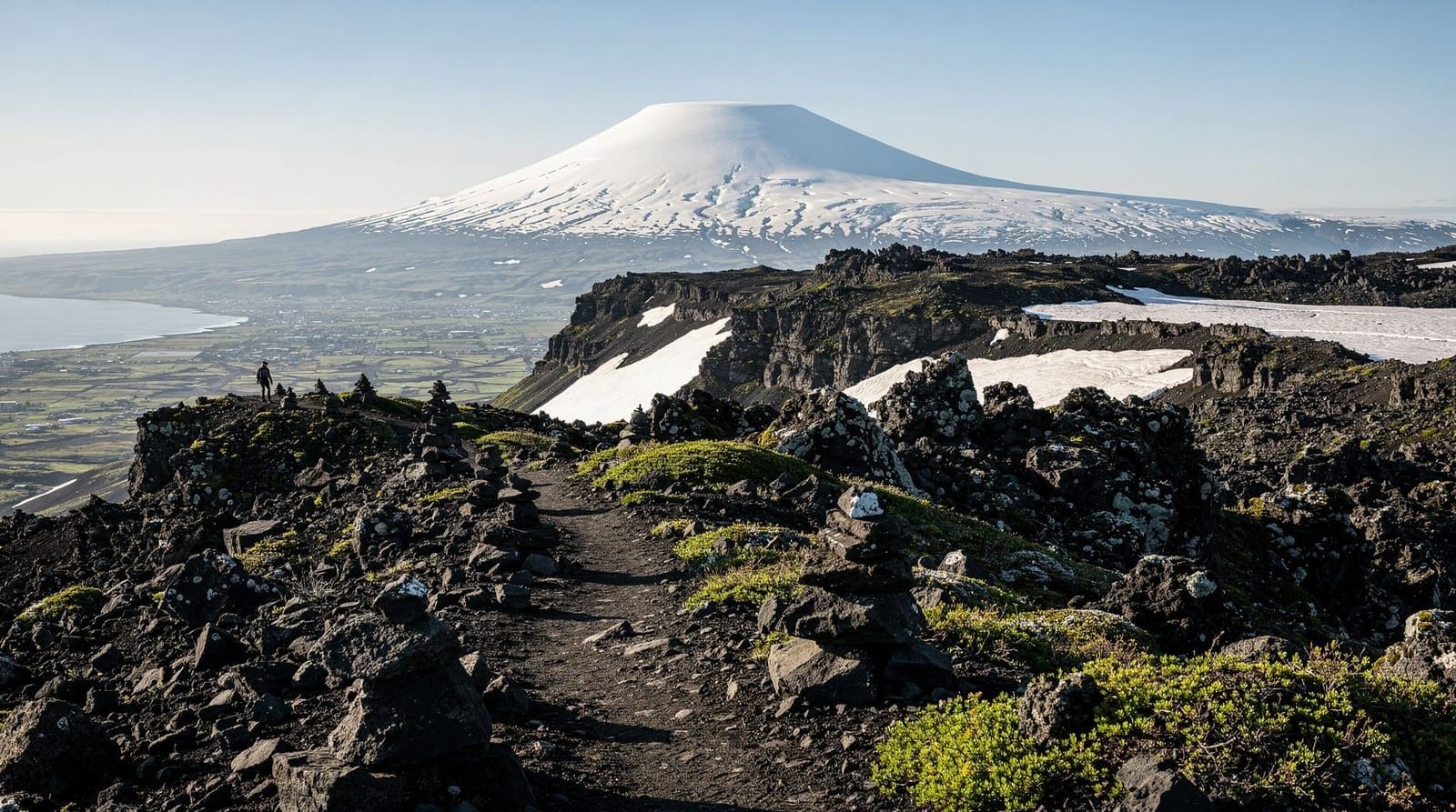
Reykjavik: Landmannalaugar pearl of the Highlands
Is Iceland good for hiking, and when is the best time to go?
Iceland offers world-class hiking across all difficulty levels. The main season runs from late June to mid-September, when highland routes are accessible and huts are staffed. July gives the most reliable weather; August is drier than June in the highlands. Winter hiking requires specialist experience.
Iceland is an exceptional hiking destination with a catch: the window in which most routes are safely accessible is short (late June to mid-September), the weather is genuinely unpredictable, and the highland terrain requires specific logistics that differ from hiking elsewhere in Europe. Get those logistics right and the experience is extraordinary — landscapes that genuinely do not exist anywhere else, trail systems that cross active volcanic terrain and glacial moraine, and long summer daylight that makes 15-hour hiking days possible.
This guide covers everything you need to plan a hiking trip, from choosing the right trail for your fitness to booking huts 9 months in advance.
Choosing the right trail for your level
Beginner and family-friendly
Reykjadalur hot spring hike — 6 km return from Hveragerði, 200 m ascent, 2–3 hours. The most accessible natural hot spring hike in Iceland, ending at a river where you can bathe. No technical difficulty. Good for first-time hikers and older children.
Glymur waterfall hike — 7 km loop, 400 m ascent, 3–4 hours. Iceland’s second highest waterfall (198 m) reached by a moderate hillside trail with one log bridge crossing. Dramatic scenery for the effort involved.
Skógarfoss waterfall canyon (lower section) — 4 km one way up the Skógar river canyon, 300 m ascent. Part of the Fimmvörðuháls route but walkable as a standalone half-day hike with 20+ waterfalls.
Þingvellir rift valley — Flat walks along the North American and Eurasian tectonic plate boundary in Þingvellir National Park. No significant ascent; suitable for all fitness levels.
Moderate
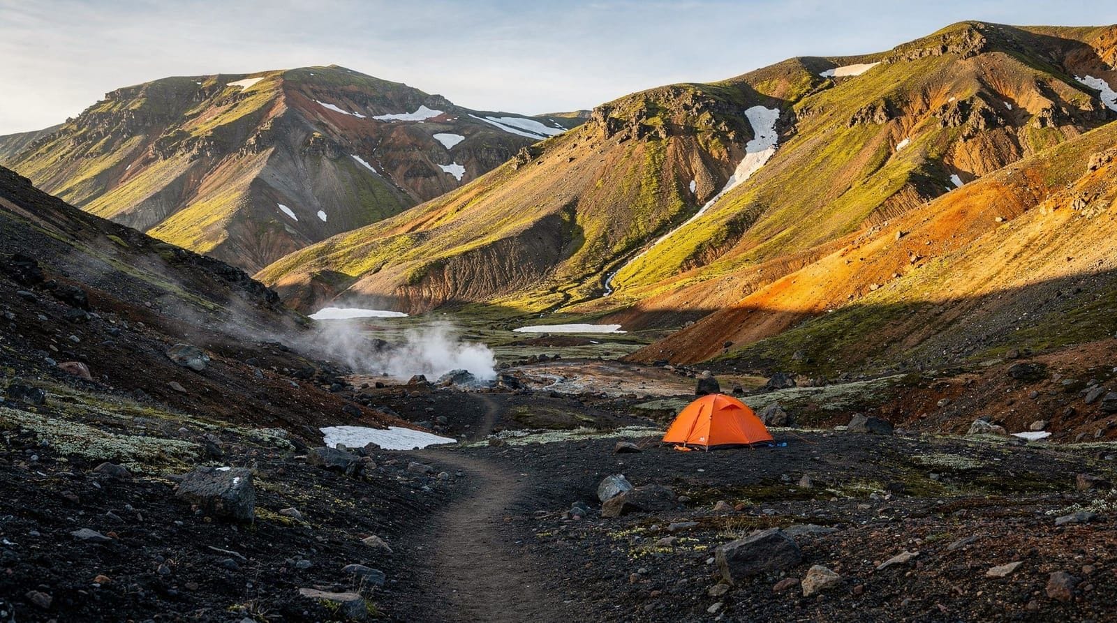
Landmannalaugar day hikes — Multiple options from the Fjallabak trailhead, ranging from 4 km (Brennisteinsalda loop) to 13 km (Ljótipollur crater). Require highland transport. The most colourful terrain in Iceland.
Skaftafell glacier hikes — Trails from the visitor centre in Vatnajökull National Park to glacier viewpoints and the Svartifoss waterfall. Well-maintained paths on one of Iceland’s premier glacier edges.
Kirkjufell circumnavigation — 4 km loop around Kirkjufell mountain on the Snæfellsnes Peninsula, with the famous waterfall foreground. Mostly flat, some rough terrain.
Challenging
Fimmvörðuháls hike — 24 km single day from Skógar to Þórsmörk, 900 m ascent in the first 8 km, crossing a volcanic pass between two glaciers. Iceland’s most demanding single-day hike.
Laugavegur trek — 55 km over 4 days from Landmannalaugar to Þórsmörk. Moderate difficulty sustained over 4 days with river crossings and highland weather.
Askja and Kerlingarfjöll — Remote highland destinations requiring significant drive on F-roads. The hikes themselves are moderate in difficulty but the access logistics are serious.
The seasonal access calendar
| Route | Open (typical) | Notes |
|---|---|---|
| Reykjadalur, Glymur, coastal | Year-round | Ice possible in winter |
| Landmannalaugar area | Mid-June to early Oct | F-roads dependent |
| Laugavegur trail | Mid-June to mid-Sept | Huts open mid-June |
| Þórsmörk valley | Late June to mid-Sept | River crossings variable |
| Fimmvörðuháls pass | Early July to mid-Sept | Snow on pass until late July |
| Askja, Kerlingarfjöll | Late June to late Sept | F-road conditions apply |
| Snæfellsnes Peninsula | Year-round | Some trails icy Oct–Apr |
Attempting highland routes before the official opening carries serious risk. Snow bridges over rivers can collapse; glacial melt rivers can be at 150% normal flow; trail markers are buried.
Safety: what actually goes wrong
Iceland’s search and rescue service (ICE-SAR) handles hundreds of callouts per year, with a significant proportion involving unprepared hikers. Common scenarios:
Getting caught in weather. Forecasts for the highlands can change within 2 hours. A clear morning does not guarantee a clear pass crossing. Always carry layered clothing and waterproofs even when the weather looks good at departure.
River crossing accidents. Glacial rivers that look knee-deep can have very fast currents. People are swept off their feet every summer season. Rules: unbuckle pack straps, use a pole, cross early morning, turn back if water is above mid-thigh.
Navigation failure. In cloud or heavy rain, trail markers become invisible. Download offline maps on Gaia GPS, maps.me, or the AllTrails app before entering the highlands. Paper topographic maps are useful backup.
Hypothermia. July temperatures at highland elevation can drop to 3–5°C with wind chill. Wet clothing accelerates heat loss. If someone in your group starts shivering uncontrollably, stops talking coherently, or becomes clumsy — get them into dry layers and seek shelter immediately.
Fitness underestimation. The Laugavegur looks manageable on paper; 15 km with a 12 kg pack on uneven terrain is significantly harder than 15 km on flat ground. Be realistic about your fitness before committing to multi-day routes.
Highland hut booking logistics
The FÍ (Ferðafélag Íslands / Icelandic Touring Association) operates the main highland hut network. Key facts:
- Bookings open annually in January at fi.is for the coming summer season
- July beds sell out within hours to days of the booking window opening
- Sleeping-bag accommodation costs ISK 14,000–17,000 (EUR 90–110) per person per night
- Camping at hut sites costs ISK 3,500–5,000 (EUR 22–32) per person per night
- All huts have kitchen facilities and toilets; most have paid showers
- Huts are staffed; wardens can advise on conditions and call for help if needed
Alternative option: Húsadalur/Volcano Huts at Þórsmörk offers more comfortable accommodation at higher prices (from ISK 20,000/person in dorms) and operates its own bus service.
If highland hut logistics feel complex, a guided day tour to Landmannalaugar handles transport and includes a guided hike through the rhyolite hills — no advance booking required beyond the tour itself.
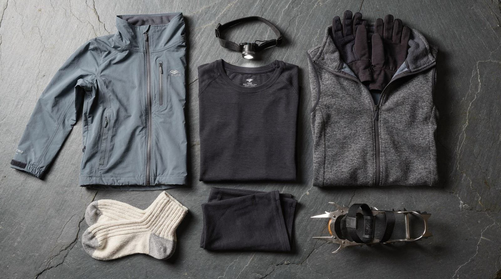
Gear that matters
The mistake most first-time Iceland hikers make is packing gear appropriate for a European mountain walk but not for sustained rain, wind, and cold. The specific items that matter:
Waterproof jacket: must be fully seam-sealed and rated for heavy rain. A shower-resistant shell that works in a light drizzle will be soaked through in an Icelandic squall within 30 minutes.
Waterproof trousers: often forgotten, always needed. Rain from below (wind-driven) enters through trouser legs on exposed ridges.
Gaiters: useful on any trail involving river crossings, wet heath, or scree. Not essential on maintained park trails.
Footwear: waterproof leather or synthetic hiking boots with ankle support. Trail runners are popular but cold and wet when rivers are involved.
Base layers: merino wool or synthetic; no cotton. Cotton stays wet and causes rapid heat loss.
Layers: a mid-weight fleece or down jacket for above 800 m, even in July.
Navigation: phone with offline maps downloaded, backup battery, and ideally a paper map.
Emergency: personal locator beacon (available to rent in Reykjavík) for highland routes.
Highland transport options
Getting to trailheads in the interior requires planning:
Highland buses: Reykjavík Excursions (re.is) and Trex (trex.is) run scheduled services from Reykjavík BSÍ to Landmannalaugar, Þórsmörk, and other highland destinations. Booking required.
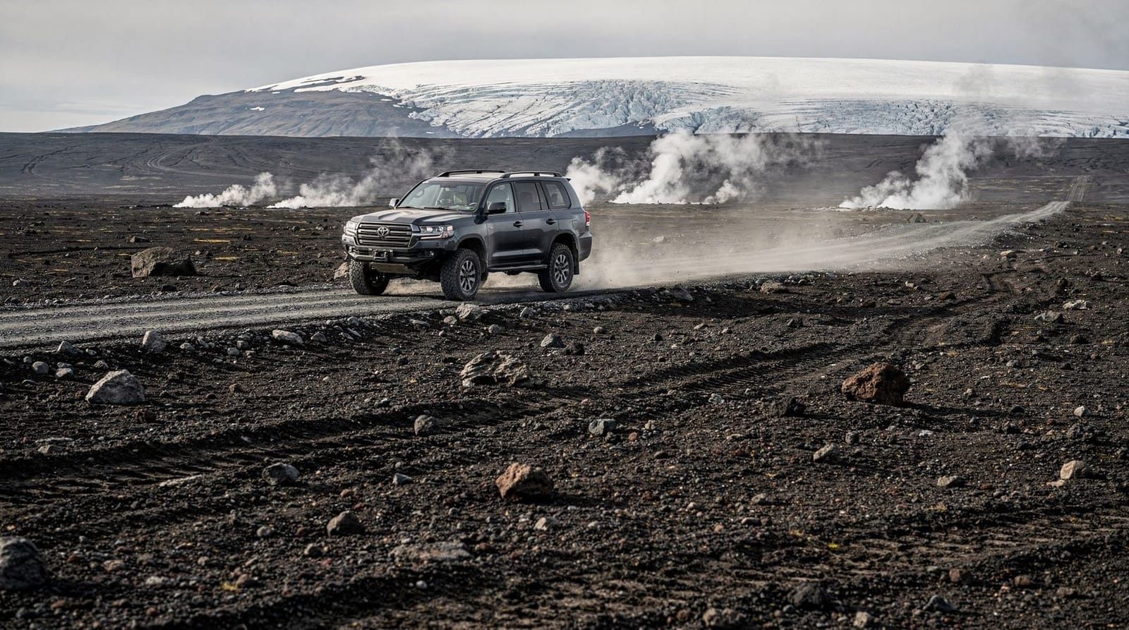
4WD rental: F-roads require a 4WD vehicle with high clearance. Standard SUVs (RAV4, CRV) manage most F-roads but not the deepest river crossings. Super-jeeps handle everything but are expensive to rent. See F-roads Iceland for details.
Guided tours with transport: the most hassle-free option for single destinations.
Super-jeep guided tours to Þórsmörk include transport from the south coast and a guided hike — the lowest-logistics way to access one of Iceland’s premier hiking valleys.
Where to hike near Reykjavík without highland transport
Several excellent hikes are accessible from Reykjavík without F-road transport:
- Reykjadalur hot spring hike — 40 minutes from Reykjavík by bus to Hveragerði
- Glymur waterfall hike — 1 hour from Reykjavík by car or bus to Hvalfjörður
- Esja mountain (15 km return, 914 m summit) — 30 minutes from Reykjavík, visible from the city
- Krýsuvík geothermal fields — 45 minutes by car on the Reykjanes Peninsula
These routes are walkable year-round (with appropriate winter gear) and need no booking.
Frequently asked questions about hiking in Iceland
Is it safe to hike alone in Iceland?
Solo hiking is common and the trail network is well-established. Register your hiking plan at safetravel.is and carry emergency communication (PLB or satellite phone) on any highland route. On popular summer trails, other hikers are nearby.
Do I need to book guided tours in advance?
For July, yes — popular guided hikes sell out. Independent hikers using huts should book huts in January (fi.is). Day hikes on public trails require no booking.
What should I do if I get lost or injured?
Call 112 (Iceland emergency). Give your GPS coordinates if possible — the Safetravel app includes an emergency SOS function. ICE-SAR operates across the country with volunteer mountain rescue teams.
Are dogs allowed on Iceland hiking trails?
In national parks (Þingvellir, Vatnajökull, Snæfellsnes), dogs are prohibited. On open highland trails, dogs must be on a leash. Iceland has strict quarantine rules for bringing animals into the country.
Can I use hiking poles in Iceland?
Yes and they are strongly recommended. Poles provide stability on river crossings, reduce knee impact on descents, and help on steep or icy terrain. Collapsible trekking poles pack easily in luggage.
Is there a hiking “off season”?
Late August and early September offer fewer crowds on popular routes, while huts and buses are still operational. September brings the first autumn colours to the birch woodland in Þórsmörk. The official season ends mid-September when most highland buses stop.
Regional hiking overview
Iceland’s regions offer distinct hiking characters worth matching to your interests:
South Iceland and the Golden Circle
South Iceland contains the highest density of accessible hiking for visitors based in Reykjavík. The Reykjadalur valley hike starts 45 minutes from the capital. The Fimmvörðuháls upper section of the Skógarfoss waterfall canyon starts 2.5 hours away. The south coast between Seljalandsfoss and Skógar has multiple maintained trails accessible without a 4WD.
The Þórsmörk valley — the end of the Laugavegur trail — is accessible from the south coast by super-jeep bus. The valley trails, from the short Valahnúkur viewpoint (1.5 hours return) to the demanding Tindfjöll ridge (4–5 hours), cover a wide range of difficulty.
Highlands (Landmannalaugar, Kerlingarfjöll, Askja)
The central and northeast highlands offer Iceland’s most dramatic hiking terrain but require F-road logistics. Landmannalaugar is the most accessible major highland destination and the starting point for the Laugavegur trek. Kerlingarfjöll is slightly more accessible via the F35 Kjölur route. Askja requires the most significant planning but rewards it with one of the most impressive calderas in Europe.
West Iceland and Snæfellsnes Peninsula
The Snæfellsnes Peninsula offers a concentrated collection of accessible hiking around the Snæfellsjökull volcano. Kirkjufell mountain is the peninsula’s signature peak. The walks in Snæfellsjökull National Park include coastal paths, lava tube entrances, and viewpoints over the Faxaflói bay. The Glymur waterfall hike near Hvalfjörður is the best single-day hike within an hour of Reykjavík.
North Iceland
North Iceland is substantially less visited by international hikers than the south but has excellent trails. The Diamond Circle area around Húsavík and Lake Mývatn includes the Hverfjall tuff ring hike (2 hours, extraordinary views), the Dimmuborgir lava formation walking paths, and the approach to Dettifoss waterfall. The Arctic coast way connects multiple north coast settlements along a 900 km long-distance trail (multi-week expedition-level route, not for casual visitors).
Westfjords
The Westfjords contain some of Iceland’s wildest and most remote hiking, including the Hornstrandir Nature Reserve in the far north — accessible only by ferry and with no roads or rescue infrastructure. Trails here require expedition planning. The more accessible south Westfjords around Dynjandi waterfall and the Látrabjarg cliffs offer shorter day hikes in spectacular scenery.
Responsible hiking in Iceland
Iceland’s highland terrain is exceptionally fragile. Several practices matter significantly:
Stay on marked trails. The moss and vegetation covering highland areas takes decades to regenerate after being walked on. Trampling creates erosion scars that last for generations. The black moss deserts you see on some highland slopes are partially the result of historic grazing and trampling.
Use designated toilet facilities. Bury human waste at least 100 m from any water source and pack out toilet paper. Do not use soft highland moss as tissue — it does not decompose quickly.
Take nothing. Collecting rocks, flowers, or other natural material from national parks and nature reserves is prohibited. The obsidian at Landmannalaugar and the basalt columns at Svartifoss are not souvenirs.
Do not walk in geothermal areas. The coloured soil around steam vents marks geothermally active ground where the surface crust is thin over very hot water. Stay on marked paths in all geothermal areas.
Low-impact camping. Wild camping is allowed in most of Iceland (outside national parks) but the Leave No Trace principles are not optional. Carry out all waste; do not light fires except in designated areas; pitch tents on hard or peaty ground rather than on fragile vegetation.
Guided vs independent hiking in Iceland
The question of whether to hire a guide for Iceland hiking has a straightforward answer: guides add value for specific categories of hike and are optional or unnecessary for others.
Guides add value for:
- Glacier hikes (safety assessment, crampons instruction, crevasse navigation)
- Ice caves (only guides with certified operators are permitted access to most caves)
- F-road highland destinations where driving expertise is the main challenge
- First-time highland hikers on the Laugavegur who are not confident about river crossing decisions
Guides are unnecessary for:
- Established day trails with clear markers (Reykjadalur, Glymur, Skaftafell, Kirkjufell)
- The Laugavegur trek for experienced multi-day hikers with proper gear and registration
- Any south coast or Golden Circle walk accessible by standard car
Cost reference for guided hiking in Iceland:
- Half-day guided day hike from Reykjavík (with transport): ISK 15,000–22,000 per person
- Full-day guided highland hike: ISK 25,000–40,000 per person
- 4-day guided Laugavegur (all-inclusive): EUR 900–1,600 per person
- Glacier walk (3–4 hours, includes crampons and guide): ISK 10,000–16,000 per person
Essential apps and websites for Iceland hiking
vedur.is — the Icelandic Meteorological Office. The only reliable source for highland weather forecasts. Check the mountain and highland forecast specifically — the Reykjavík forecast is irrelevant for pass conditions.
safetravel.is — hiking plan registration. Takes 5 minutes; potentially saves your life. The Safetravel app also has emergency SOS functionality.
vegagerdin.is — the Icelandic Road Administration. Real-time F-road condition data including river depth readings at key crossings. Essential if driving to highland trailheads.
fi.is — Ferðafélag Íslands (Icelandic Touring Association). Hut booking for the Laugavegur, Kerlingarfjöll, and other highland hut networks.
Gaia GPS (mobile app) — best offline mapping for Iceland hiking. Download specific areas before departure. The Iceland topographic layer is accurate and includes all FÍ hut locations.
Building your Iceland hiking trip around seasons
The optimal Iceland hiking trip depends significantly on which experience you prioritise:
Late June: the highland routes have just opened. Snow may still be on the Fimmvörðuháls pass. Rivers are at higher flow from snowmelt — river crossings more challenging. Daylight is at its maximum. Fewer international visitors than July.
July: peak season with maximum trail user numbers. All huts operating at capacity. Best weather reliability historically. The Laugavegur in July is a social experience — you share the trail with many other hikers daily. Bus bookings essential.
August: slightly lower visitor numbers than July. Weather remains good. The first aurora may be visible from late August on clear nights. The hiking season starts winding down after mid-August for some operators.
Early September: the ideal balance of open trails, low crowds, beginning autumn colour in Þórsmörk, and the first possibility of northern lights. Huts still operating; buses still running. This is arguably the best month for independent hiking in Iceland.
The practical constraint is that flights to Iceland in September are similar in price to July flights from most markets — there is no significant shoulder season discount on flights, though accommodation rates drop noticeably after the August peak.
Frequently asked questions about Hiking in Iceland
Do I need a guide to hike in Iceland?
No legal requirement exists for most routes. Trails like Reykjadalur, Glymur, and the south coast are fine to walk independently. Highland routes including Laugavegur require you to register a hiking plan at safetravel.is. Guides add value on river crossings, ice navigation, and weather assessment.What is the most important safety rule for hiking in Iceland?
Register your hiking plan at safetravel.is before any highland trip. This takes 5 minutes and allows ICE-SAR (the volunteer search and rescue service) to find you if you do not return. Failure to register is not illegal but has caused preventable rescue operations.Can I hike year-round in Iceland?
Coastal and low-altitude hikes (Reykjadalur, Glymur, trails near Reykjavík) are accessible year-round for equipped hikers. Highland routes are inaccessible from October to mid-June due to snow and flooded F-roads. Never attempt highland trails out of season.What are the F-road rules for hikers reaching highlands?
F-roads require a 4WD vehicle; some have unbridged river crossings. Hikers without a suitable vehicle use scheduled highland buses. Attempting F-roads in a standard hire car voids your insurance contract.How do I book huts on the Laugavegur and other highland routes?
The Ferðafélag Íslands (FÍ / Icelandic Touring Association) operates most highland huts. Bookings open each January at fi.is for the coming summer. July beds sell out within hours of opening.Is hiking expensive in Iceland?
Trail access is generally free. Costs come from transport (highland buses cost ISK 8,000–12,000 per trip), hut accommodation (ISK 14,000–17,000 per night), and food. A 4-day Laugavegur with huts costs roughly EUR 500–650 in accommodation and transport per person.What wildlife might I encounter hiking?
Iceland has no land predators. Common wildlife: ptarmigan (highland ground birds), Arctic foxes (highlands and coasts), various bird species including golden plover. On coastal routes, seabirds including puffins are common in summer. No snakes or dangerous insects.
Top experiences
Bookable activities with verified prices and instant confirmation on GetYourGuide.

Top experiences
Best-rated activities across GetYourGuide and Viator.

Sólheimajökull Glacier Hike – Adventure in a Small Group
- Viator

Blue Ice Discovery – Guided Glacier Hike from Skaftafell
- Viator

Glacier Hike from Skaftafell - Extra Small Group
- Viator

Sólheimajökull Glacier Hike - Small Group Blue Ice Adventure
- Viator

Skaftafell Glacier Hike 3-Hour Small Group Tour
- Viator

Solheimajokull Glacier 3-Hour Small-Group Hike
- Viator