Þingvellir National Park — tectonic rift, Silfra, and Iceland's first parliament
Guide to Þingvellir: walk the tectonic rift, snorkel Silfra, and visit Iceland's historic parliament site. Admission, Silfra prices, and driving
Reykjavik: Silfra snorkeling between two continents
Quick facts
- Best time to visit
- Year-round; June to August for hiking; Silfra snorkelling runs all year
- Days needed
- Half day to full day (plus Silfra if booked)
- Getting there
- 45 km east of Reykjavík on Route 36; about 45 minutes by car
- Budget per day
- ISK 750 parking / EUR 5; Silfra snorkel ISK 22,000–28,000 / EUR 145–185
Where two continents meet above ground
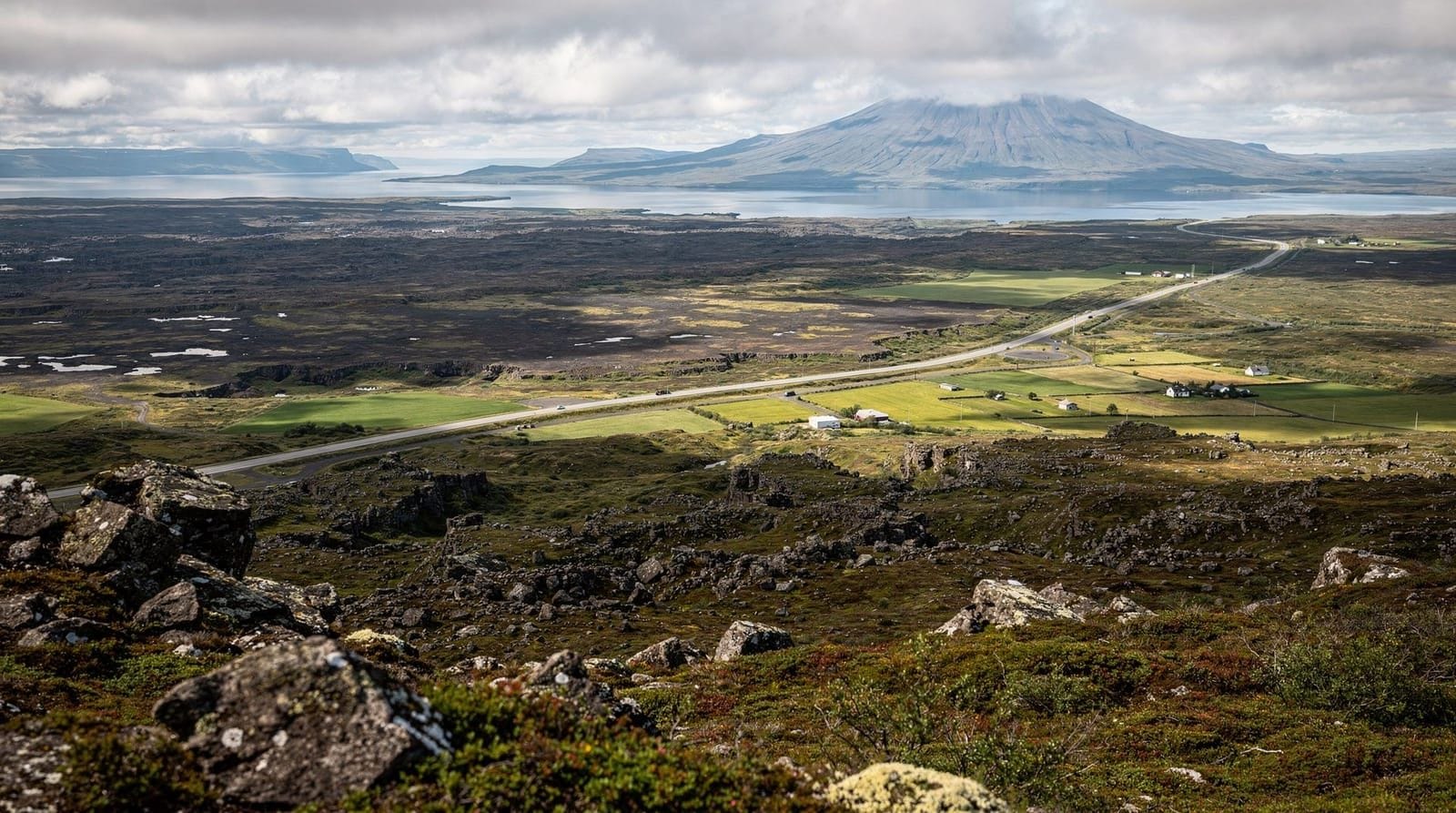
Þingvellir is one of the few places on Earth where a mid-ocean ridge sits above sea level, visible and walkable. The Mid-Atlantic Ridge divides the North American and Eurasian tectonic plates across the floor of the Atlantic Ocean, but at Þingvellir, it surfaces. The Almannagjá gorge — the fissure running through the main visitor area — is the boundary between the two plates. North America is on your left; Eurasia is on your right. The plates are moving apart at approximately 2 centimetres per year.
This is not a metaphor or a loose geographic concept. You can stand in the gap, look up at 30-metre basalt walls on either side, and be literally between two continents. The fissure system continues underwater in Þingvallavatn lake to the south, and Silfra — the most famous dive site in Iceland — is a water-filled section of the same rift.
Þingvellir was designated Iceland’s first national park in 1930 and is a UNESCO World Heritage Site (inscribed 2004) on dual grounds: its geological significance and its historical role as the site of Iceland’s founding parliament, the Alþingi, which first met here in 930 CE.
The Almannagjá rift walk
The main visitor path descends into the Almannagjá gorge from the northern car park (P1) and runs south for about 1.5 km to the Lögberg (Law Rock) — the raised platform where the law-speaker recited the laws of the land annually during the Alþingi sessions. The flat, wide path is accessible for most fitness levels and is paved in parts.
Standing in the gorge and looking along its length gives a clear sense of what a tectonic rift actually looks like at human scale. The walls are sheer basalt, formed from ancient lava flows, and the gap is 30–70 metres wide in places. The floor is often damp — springs emerge from the base of the walls year-round, feeding the river Öxará that runs through the park.
There is no charge to walk the Almannagjá trail. Parking at P1 (the main visitor centre car park) costs ISK 750 (EUR 5). The visitor centre has a café (soup ISK 2,200 / EUR 14, open-face sandwiches ISK 1,800–2,500 / EUR 12–16) and a small exhibition on the park’s geology and history.
Þingvallavatn lake
Þingvallavatn is Iceland’s largest natural lake, at 84 square kilometres. It fills the graben (the sunken block between two faults) formed by the tectonic rifting. The lake is glacially cold, exceptionally clear, and biologically rich — it hosts four endemic species of Arctic charr, thought to have evolved from a single common ancestor after the lake was isolated from the sea following the last ice age.
From the Hakið viewpoint on the cliff above the main car park, you can see the full extent of the lake and the lava fields beyond it. This is one of the best panoramic views in the Golden Circle area and is often overlooked by visitors who head straight to the gorge.
Silfra — snorkelling and diving in the rift
Silfra is a fissure in Þingvallavatn filled with glacially filtered groundwater. The water passes through a lava field from Langjökull glacier over a period of 25–100 years, filtering it to extraordinary clarity — horizontal visibility exceeds 100 metres, making it consistently ranked among the best dive sites in the world. Water temperature is a constant 2–4°C year-round.
The Silfra dive/snorkel experience has three sections: the Hall (narrow entry, walls rising close on either side), the Cathedral (wider, with the most dramatic ceiling-like rock formations), and the Lagoon (the exit area). The total underwater route is about 300 metres, taking 30–45 minutes.
Snorkelling requires no certification but does require the ability to swim and comfort in cold water (drysuits are provided and mandatory). Scuba diving requires a current open water certification and at least 30 logged dives.
Silfra snorkelling between two continents — from Reykjavík — full drysuit snorkel tour including transport from Reykjavík, drysuit and equipment, guide, and hot chocolate after. ISK 22,000–26,000 (EUR 145–170). This is the standard format and is run by several well-established operators. The cold is real — most participants describe a face-ache during the first 5–10 minutes that passes as you adjust. The experience is genuinely striking.
Golden Circle and Silfra snorkelling combo — combines the full Golden Circle loop (Þingvellir, Geysir, Gullfoss) with a Silfra snorkel session. ISK 35,000–45,000 (EUR 230–295) for a full day. This is a long day but avoids the need to visit the park twice.
Advance booking is essential for Silfra, particularly in summer. The access slots are limited by the national park and fill weeks ahead in July and August.
The historical parliament site
The Alþingi met at Þingvellir annually from 930 CE until 1798, making it one of the world’s oldest continuous parliamentary assemblies. The original site functioned as a legal and commercial assembly as well as a legislature — disputes were settled, laws proclaimed, and trading done. The Christianity of Iceland was decided by vote here in 999 CE. Executions (by drowning in the Drekkingarhylur pool, used for convicted criminals) also occurred on site.
The Alþingi was moved to Reykjavík in 1798 when the country shifted to Danish rule. Iceland’s independence was formally proclaimed back at Þingvellir on 17 June 1944 — chosen deliberately for its historical resonance. June 17 remains Iceland’s National Day.
The Lögberg (Law Rock) is marked with an Icelandic flag on the rift wall; the original exact location is unknown, and the current marker is historically approximate. The church (Þingvallakirkja), rebuilt in 1859 on older foundations, and the nearby government farmhouse remain in use and are visible from the main path.
Trails beyond the main gorge
The park covers 237 square kilometres. Beyond the Almannagjá walk, there are several other hiking options:
Nešjalaugar trail (3 km): Runs along the lakeshore from the main visitor area to the Nesjar geothermal area. Hot springs visible from the path.
Hakið circuit (5 km): Loops from the south car park (P2) to give views of the lake and lava fields.
Arnarfell hike (10 km round trip): Reaches a high ridge north of the visitor area with views across the entire rift valley. Requires more time and energy; suitable for fit hikers.
All trails are free. Signed in Icelandic and English. Conditions on higher trails can be icy from October through May.
The Alþingi and Iceland’s legal history
The significance of Þingvellir as a parliamentary site deserves more than a brief mention. The Alþingi met here annually from 930 CE — approximately two weeks each summer — as a combined legislature, court, and market. It was one of the world’s first national assemblies and operated under a legal code (the Grágás, or “Grey Goose Laws”) that was recited from memory by the law-speaker, who had a three-year term memorising and proclaiming the laws.
The Alþingi was not a democratic assembly in the modern sense — only free men (landowners and their representatives) participated. But it was a genuine legal institution that resolved disputes, made law, and maintained order across a scattered island settlement. The 999 CE decision to adopt Christianity was made by vote at the Alþingi in a compromise engineered by Þorgeirr Þorkelsson, a pagan law-speaker, who lay under his cloak for a day and a night before announcing that Iceland would convert to Christianity officially while allowing private pagan practice.
The Drekkingarhylur (“Drowning Pool”) near the church was used for executions: convicted criminals and, in particular, women convicted of infanticide or adultery, were drowned here during the Alþingi sessions. Male criminals were more commonly hanged or beheaded on the adjacent hill. The pool is still visible — a dark backwater of the Öxará river. The historical records of executions at Þingvellir are documented in detail in the Icelandic sagas.
The Alþingi was moved to Reykjavík in 1798 during the period of Danish administrative reorganisation. The parliamentary building in central Reykjavík (Alþingishúsið) now serves as Iceland’s parliament. June 17, 1944 — the date Iceland declared full independence from Denmark — was deliberately chosen to be proclaimed at Þingvellir, with 20,000 Icelanders present. That date is now Iceland’s National Day.
Geology of the rift valley
The Þingvellir graben — the sunken block between the parallel fault systems — is subsiding at approximately 1–2 mm per year as the two plates pull apart. The Þingvallavatn lake basin is the result of this subsidence over thousands of years. The rift zone runs through the park in a northeast-southwest orientation consistent with the broader Mid-Atlantic Ridge trend.
Beyond the Almannagjá, which is the western boundary fault, there is a second major fault (Hrafnagjá) running parallel to the east. The valley floor between these two fault systems is the top of the sunken block. The total rift width through the park is approximately 7 km; the height difference between the rift walls and the valley floor is up to 30–40 metres.
Active rifting events — seismic activity associated with plate movement — occur periodically. The 2000 earthquake near Selfoss (magnitude 6.6) produced measurable displacement in the Þingvellir area. Geologists monitoring the park have documented consistent northward displacement of the North American side relative to the Eurasian side.
Wildlife and birdwatching
The lake and surrounding wetlands attract significant birdlife. Great northern divers (loons) nest on Þingvallavatn; their calls across the water at dusk are one of the characteristic sounds of the park. Whooper swans are present most of the year. Arctic terns nest aggressively near the walking paths in June–July and will dive at visitors who come near nesting sites (this is normal; a hat or raised arm is adequate defence).
Gyrfalcon — Iceland’s apex raptor and the largest falcon in the world — hunts over the lava fields. Sightings are real but not guaranteed.
Practical information
Getting there: Route 36 from Reykjavík, clearly signposted. The drive takes about 45 minutes in normal conditions. No public bus serves the park directly; renting a car or joining a guided tour are the practical options.
Parking: P1 (main visitor centre, north) is ISK 750 / EUR 5. P2 (south, near Silfra launch site) is also ISK 750 / EUR 5. Parking is paid via a phone app or card machine.
Silfra access: The Silfra entry point is at P2 in the south of the park, not at the main visitor centre. Tour operators provide the specific meeting point.
Opening hours: The park is open 24 hours. The visitor centre is open 09:00–18:00 in summer, shorter hours in winter.
Facilities: Café, toilets, and a small museum at the main visitor centre (P1). Toilets also at P2. No petrol or shops inside the park.
Frequently asked questions about Þingvellir
Is Þingvellir free to enter?
Walking the Almannagjá trail and visiting the park on foot is free. Parking costs ISK 750 (EUR 5) per vehicle. Silfra snorkelling and diving tours are operated by private companies with their own pricing (ISK 22,000–28,000 / EUR 145–185 for snorkelling).
Can I swim in Silfra without a tour?
No. The Silfra entry is accessed via a ladder on the lake shore at a controlled access point managed by tour operators. Independent access is not available; you must book through a licensed tour operator. The setup requires specific drysuit equipment and safety briefing.
How cold is the Silfra water?
A constant 2–4°C year-round. Drysuits are provided and mandatory. Most people find the face and hands the most uncomfortable (face is exposed; gloves are thin). Cold-weather hands are common; the experience is 30–45 minutes in water, not hours.
Is Þingvellir worth visiting without doing Silfra?
Yes. The Almannagjá walk is impressive purely as geology and history without the water element. The panoramic view from Hakið viewpoint over the lake is excellent. Silfra is the standout active experience, but the park rewards a visit on its own terms.
Is Þingvellir accessible in winter?
Yes. The main Almannagjá path is cleared after snowfall. Ice can form on the rocks and steps; walking poles and/or micro-spikes are useful from November through March. The Silfra tours run year-round. Winter light on the rift walls is striking.
How long should I spend at Þingvellir?
Allow 2–3 hours for the main visitor area — the gorge walk, Lögberg, and Hakið viewpoint. Add 3–4 hours if you are doing Silfra (snorkelling plus preparation and recovery time). A full day at Þingvellir is possible if you hike the longer trails, but most Golden Circle tours allocate 1.5–2 hours at the park, which is adequate for the highlights.
Top experiences
Bookable activities with verified prices and instant confirmation on GetYourGuide.

Top-rated experiences in Þingvellir National Park — tectonic rift, Silfra, and Iceland's first parliament
Best-rated activities across GetYourGuide and Viator.