Dynjandi waterfall
Dynjandi is the Westfjords' iconic waterfall — a 100-metre tiered cascade in a remote fjord. Guide to visiting independently or on a tour from Ísafjörður.
Ísafjörður: Isafjordur Dynjandi express
Duration: 3.5 hours, from $81, 4.7 stars (1579 reviews)
Quick facts
- Best time
- June–August for full water flow and road access; July for maximum cascade
- Days needed
- 2–3 hours including hike and photography; combine with Ísafjörður for a day trip
- Getting there
- 60 km south of Ísafjörður on Route 60 (75–90 min); 280 km from Reykjavík (4–5 hours)
- Budget per day
- Free entry; budget accommodation nearby from 15,000 ISK / €102
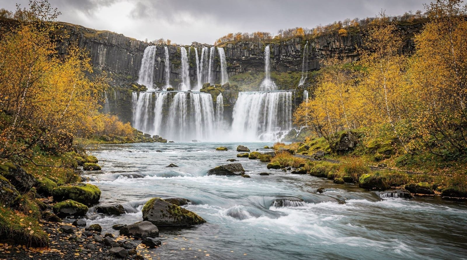
Dynjandi — meaning “the thundering one” — is a tiered waterfall system at the head of Arnarfjörður fjord in the southern Westfjords. The main cascade, Fjallfoss, drops 100 metres and fans out from a narrow lip at the top to 60 metres wide at the base. Below it, six smaller cascades follow in succession down the hillside, each with a different character. The combination of the widening fan shape, the sequence of falls, and the fjord backdrop makes Dynjandi visually distinctive — it photographs differently from any other Icelandic waterfall.
It receives perhaps a tenth of the visitor numbers that Skógafoss or Seljalandsfoss see on a summer day. In July, a busy morning at Dynjandi means 30–50 people. That is the Westfjords difference.
Getting there
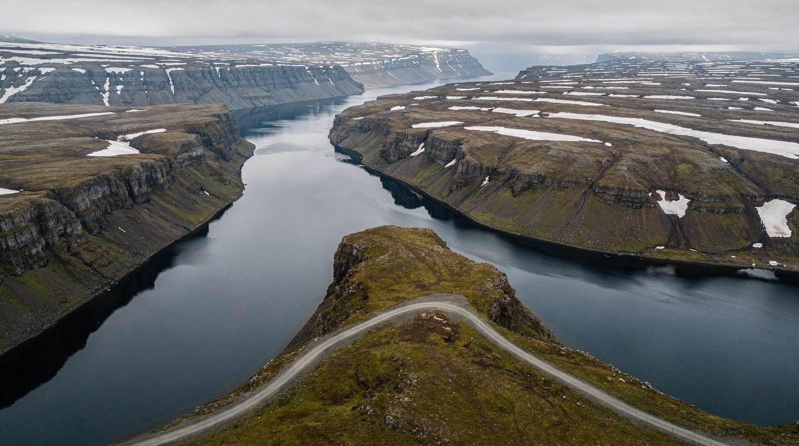
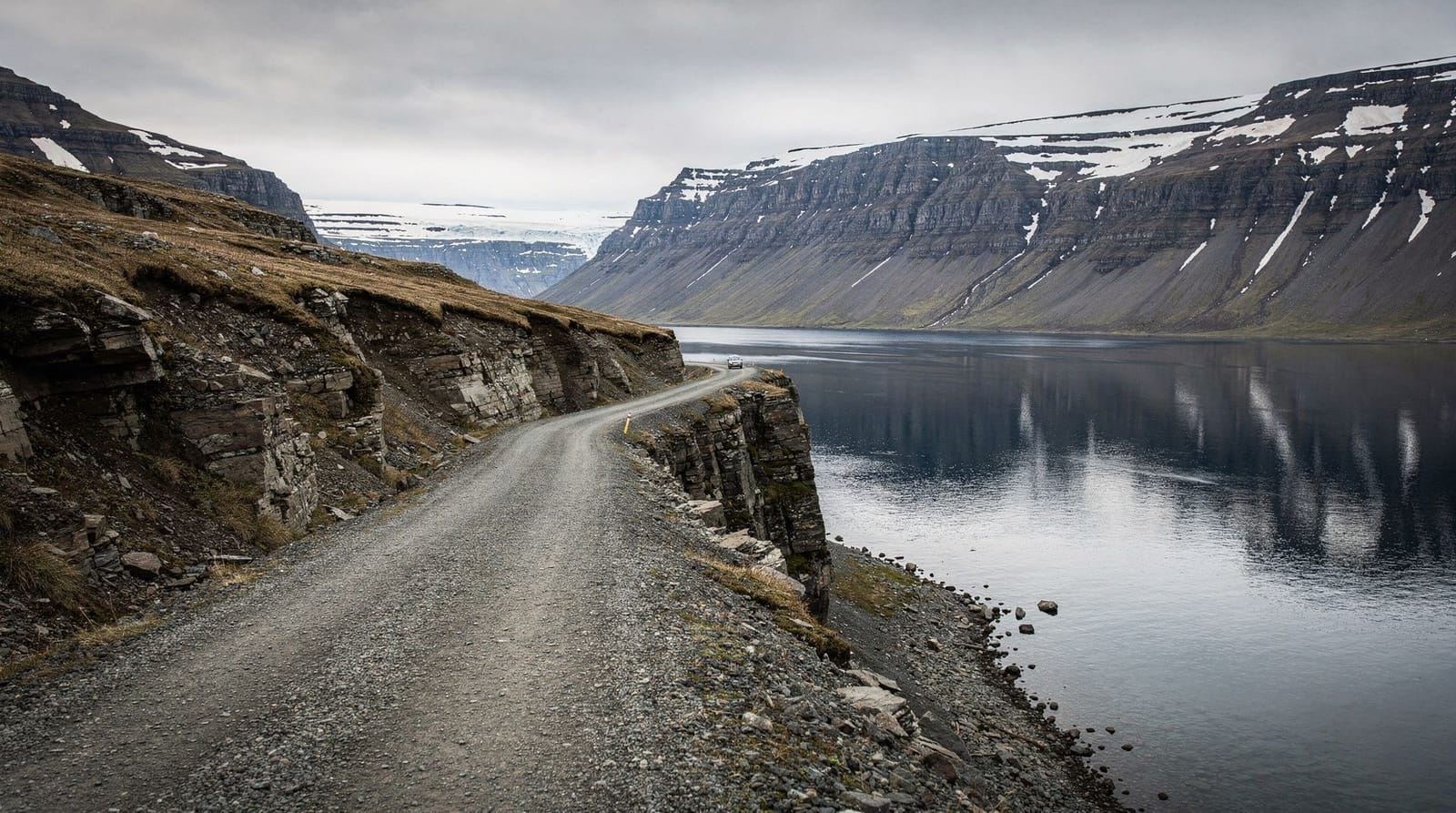
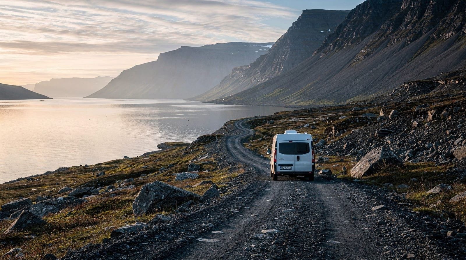
From Ísafjörður: Route 60 south, about 60 km (75–90 minutes on mixed paved and gravel road). The road quality is acceptable for 2WD in summer; the gravel sections have potholes and require reduced speed. The fjord views on the drive are consistent compensation.
From Brjánslækur (ferry from Stykkishólmur): Route 62 connects to Route 60 near Flókalundur, then north to Dynjandi — about 70 km (1–1.5 hours).
From Reykjavík: approximately 280 km via Borgarnes and Route 60 — minimum 4 hours’ driving without stops, realistically 5 hours including the gravel sections and a fuel stop in Patreksfjörður or Ísafjörður.
A small car park with toilets is signed off Route 60 at the fjord head. From the car park, a gravel path climbs past all six lower cascades to the base of Fjallfoss. The walk is about 800 metres each way and gains about 90 metres of elevation — 20–30 minutes up, 15–20 minutes down. It is not a technical hike, but the path is steep in sections and slippery when wet. Proper footwear is recommended.
Dynjandi express tour from Ísafjörður — 3.5 hours, well-reviewedThe waterfall system in detail
Walking up from the car park, you pass the lower cascades in sequence:
Hundafoss (immediately above the car park) — a broad, low cascade. Strompgljúfrafoss, Göngumannafoss, Hrísvaðsfoss, Kvíslarfoss, Bæjarfoss — each progressively larger and steeper. Then Fjallfoss — the main 100-metre fan waterfall whose roar becomes audible well before you reach it.
The base of Fjallfoss is about 800 metres from the car park. Getting close is possible (within 20–30 metres) on the path; spray from the falls in high-water periods reaches this distance. A waterproof layer for camera gear is sensible in July.
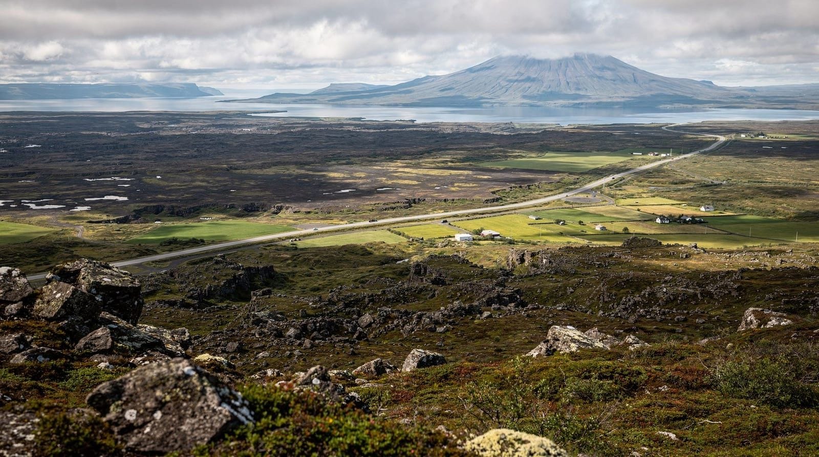
The waterfall can also be seen from across the fjord, from the road — the entire tiered system is visible as a white stripe on the hillside. This distant view gives better compositional perspective than the close-up base view and is worth stopping for before turning off to the car park.
Photography
The fan shape of Fjallfoss is the main photographic subject. The base provides the most dramatic close-up but loses the full scale. The mid-slope (about 400 metres from the car park, at the level of the middle cascades) gives a better perspective that includes both the upper fan and lower cascades. Wide-angle lenses (16–24mm equivalent) give enough coverage for the full fan at close range.
For the distant fjord view: pull over on Route 60 before the turnoff, facing north across the fjord. The tiered system and mountain backdrop are composed naturally. Early morning or evening gives better light than the flat midday.
The lower cascades have the advantage of easier framing — you can isolate individual falls against rock or spray rather than trying to capture the whole system.
Combining with nearby stops
Arnarfjörður fjord: the drive along the south shore of the fjord from the ferry road to Dynjandi is continuously scenic. The fjord is one of the Westfjords’ largest and deepest; seals are common on the tidal flats near the fjord head.
Þingeyri: a small village about 25 km north of Dynjandi (20 minutes on Route 60). It has a small café and historical interest as one of Iceland’s oldest trading posts. Basic supplies available.
Dýrafjörður and Arnarnes: driving the Westfjords loop between Ísafjörður and Dynjandi, Route 60 crosses the Dýrafjörður fjord and passes through Þingeyri, Flateyri (site of a deadly avalanche in 1995 — the protective barriers above the town are visible), and Súðavík. The Súðavík Arctic Fox Centre has exhibits on the Westfjords fox population (entry around 1,600 ISK / €11).
Dynjandi tour with Icelandic farm visit and cultural stopsPracticalities
Entry: free. The car park is free, the path is free, and there are no timed entry slots or capacity limits.
Toilets: at the car park (summer only). No café or food at the waterfall. Bring water and snacks.
Accommodation: the nearest accommodation is in Þingeyri (small guesthouses), Patreksfjörður (larger selection), or Ísafjörður. No camping directly at the waterfall, but campsite at Þingeyri.
Weather: the Westfjords is notoriously wet. Rain at Dynjandi increases the waterfall flow and adds mist effects — it is not a reason to skip the visit. Waterproof clothing is always the right choice here.
Winter access: Route 60 to Dynjandi is generally accessible year-round, but mountain passes on the Westfjords road network may close in severe winter conditions. The waterfall itself is partially frozen in winter, creating different and interesting visual conditions.
Seasonal conditions at Dynjandi
Late spring and early summer (May–June)
Snowmelt in May and June produces the highest water flow of the year. The main Fjallfoss cascade fans out at its widest and most powerful in late May and June. The fjord road may still have patches of snow or mud on mountain sections in May — check vegagerdin.is before driving. The path up to the falls is wetter and muddier than in summer proper.
Midsummer (July–August)
The peak visitor period. Even at its busiest, Dynjandi receives perhaps 30–50 visitors at a time — a fraction of comparable south coast falls. The path is dry and well-maintained. The waterfall is at full flow from snowmelt, though slightly lower volume than June as glacier and snow sources decrease. The fjord in flat-calm summer conditions creates perfect reflections from the road.
Autumn (September)
Waterfall flow begins to decrease in August and continues falling through September. The autumn light on the Arnarfjörður fjord and the hillside context of the falls is excellent — amber and low-angle. September is arguably the best month for photography at Dynjandi given the combination of colour, low visitor numbers, and usable evening light.
Winter
The waterfall partially freezes and the remaining water runs through ice formations. The path becomes genuinely dangerous with ice. Route 60 to Dynjandi is generally accessible in winter but mountain passes on side roads may close. A winter visit to Dynjandi is for experienced winter drivers only; the ice conditions are beautiful but the access requires preparation.
Photography at Dynjandi: a detailed guide
The distant fjord view (most overlooked)
Before turning off Route 60 at the Dynjandi sign, pull over on the road and photograph the waterfall system from across the fjord. At this distance (approximately 500–800 metres) you see the full tiered cascade with the mountain backdrop and the fjord in the foreground. This is actually the most compositionally complete image of Dynjandi — better than any close-up from the base. A 70–200mm telephoto compresses the distance and brings the falls into proportion with the mountains. Morning light (east-facing falls in morning) works for this distant view.
The mid-slope perspective
Walking up the path, the best single viewpoint is at the level of the fourth or fifth lower cascade (about 400–500 metres from the car park, at roughly 40 metres elevation). From here, you can frame both the lower cascades in the foreground and the upper Fjallfoss fan above. Wide-angle lens needed for this composition. The scale relationship between the lower falls and the main cascade is clearest at this height.
At the Fjallfoss base
The full width of the fan is visible from the base but the spray in high-water periods (May–July) makes long exposures difficult without waterproofing. A polarising filter reduces the spray haze on close-up shots. Wide-angle lens essential — a 16mm equivalent is needed to capture the full fan width within 20–25 metres.
Light timing
Dynjandi faces roughly south and east. Morning light (before 10 a.m.) illuminates the falls directly; midday creates flat lighting that loses texture in the spray. Evening light after 7 p.m. in summer (sun angles west toward the fjord) adds warmth and shadow definition to the rock between the cascades.
Nearby stops worth combining
Súðavík Arctic Fox Centre: 30 km north of Dynjandi on Route 60 toward Ísafjörður. Exhibits on Arctic fox behaviour and Westfjords ecology, plus outdoor enclosures with rescued foxes. Entry approximately 1,600 ISK (€11). A useful 45-minute stop on the way to or from Ísafjörður.
Flateyri avalanche barriers: Flateyri village (45 km north of Dynjandi) was struck by an avalanche in October 1995 that killed 20 people. The large concrete barriers built above the town since then are visible from the road — an unusually visible example of Iceland’s avalanche engineering. A brief stop and a significant piece of recent Westfjords history.
Þingeyri café: the small village of Þingeyri (25 km north of Dynjandi) has a basic café open in summer and an interesting small museum on the area’s trading post history. Useful for a coffee stop between Dynjandi and Ísafjörður.
Arnarfjörður seals: the tidal flats at the head of Arnarfjörður near the Route 60/Dynjandi turnoff have harbour seals. They are most visible at low tide, typically hauled out on the mudflats within easy viewing distance from the road.
Dynjandi vs the south coast waterfalls
Visitors often ask how Dynjandi compares to Skógafoss (62 metres, vertical single drop, extremely busy) or Seljalandsfoss (60 metres, walkable behind the falls, extremely busy). The comparison is between different waterfall characters:
Skógafoss is a powerful single vertical column in an accessible setting — dramatic volume, uncomplicated shape. Seljalandsfoss is wide, backwalkable, and set in a more intimate landscape. Both receive 500,000+ visitors annually at peak.
Dynjandi’s fan shape, tiered structure, and fjord setting are unique. It photographs differently from every angle and is genuinely unlike any south coast fall. The near-absence of crowds is not a drawback — it is the defining characteristic of the visit. Anyone who has already seen Skógafoss and Seljalandsfoss will find Dynjandi offers something different rather than inferior.
For pure dramatic volume, Dettifoss in north Iceland is in a category by itself (Europe’s most powerful waterfall by flow). Dynjandi is not competing on volume — it competes on visual distinctiveness and the combination of setting, solitude, and accessibility.
Frequently asked questions about Dynjandi
Is Dynjandi the most impressive waterfall in Iceland?
It is one of Iceland’s most visually distinctive waterfalls due to its fan shape and tiered structure, but “most impressive” depends on what you value. Dettifoss (north Iceland) has Europe’s most powerful flow. Skógafoss and Seljalandsfoss are taller or more accessible. Dynjandi’s advantage is the unusual visual character and the almost complete absence of crowds — qualities that matter to different people differently.
How long is the walk to Dynjandi?
About 800 metres each way on a gravel and stone path, gaining 90 metres in elevation. Allow 45–60 minutes including time at the falls. The path has steep sections; hiking poles are helpful but not essential.
Can I visit Dynjandi without going to Ísafjörður?
Yes. The waterfall is on Route 60 in the southern Westfjords, accessible directly from the ferry at Brjánslækur or by driving north from Patreksfjörður. Ísafjörður is the most common base but is not required for a Dynjandi visit.
Is Dynjandi accessible in winter?
Route 60 to Dynjandi is generally open year-round, though mountain pass sections may temporarily close. The waterfall in winter conditions (partially frozen, iced paths) is visually interesting but requires appropriate footwear and caution. Check road conditions at vegagerdin.is before driving.
Are there tours to Dynjandi from Reykjavík?
Yes — the 3-day guided Westfjords tour from Reykjavík includes Dynjandi. Day tours directly from Reykjavík to Dynjandi are not practical given the 4–5 hour drive each way. Tours from Ísafjörður are the standard option if you arrive by plane or want a guided visit.
What is the best time of year to visit Dynjandi?
June to August for full water flow (snowmelt feeds the cascade through spring and early summer). July typically has the highest volume. The waterfall operates year-round, but summer gives the best access and the most dramatic flow.
Top experiences
Bookable activities with verified prices and instant confirmation on GetYourGuide.
Top-rated experiences in Dynjandi waterfall
Best-rated activities across GetYourGuide and Viator.

Dynjandi Waterfall & Farm Visit Tour from Isafjordur Port
- Viator

3,5-Hour Sightseeing Tour To Dynjandi Waterfall
- Viator

Westfjords Whale Watching
- Viator

Small Group Tour Ísafjordur Dynjandi Waterfall & Secret Stop
- Viator

Dynjandi Waterfall in a Supertruck
- Viator

4 Hour Isafjordur and Dynjandi Tour With Photo Stops
- Viator