Glymur waterfall hike — Iceland's second highest waterfall and how to reach it
How long is the Glymur waterfall hike and how difficult is it?
The Glymur hike is a 7 km loop (or 4.5 km return to the main viewpoint) with about 400 m of elevation gain, taking 3–4 hours. The difficulty is moderate — there is one river crossing on a narrow log bridge, and the upper section involves steep loose terrain. Waterproof boots are recommended.
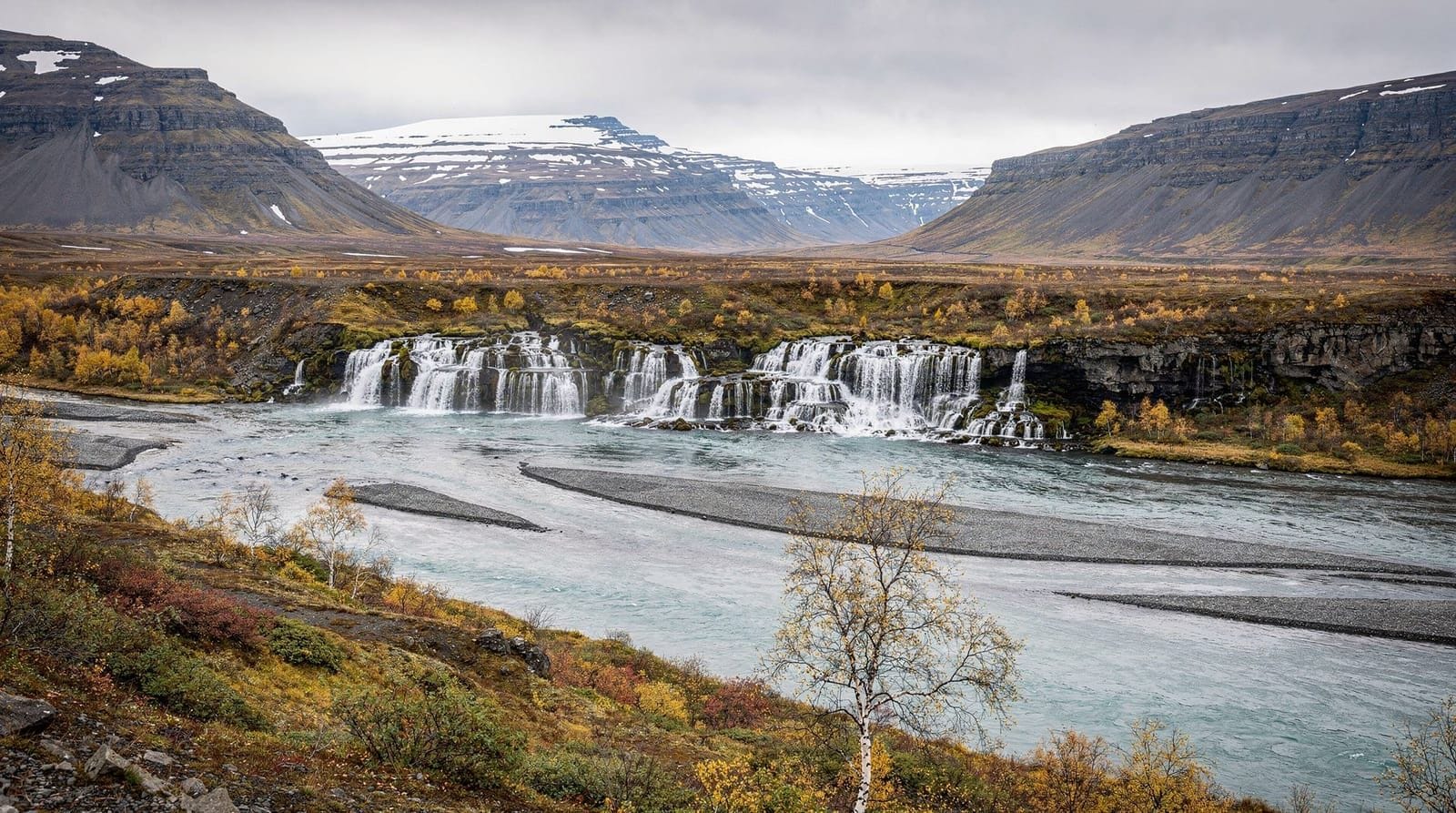
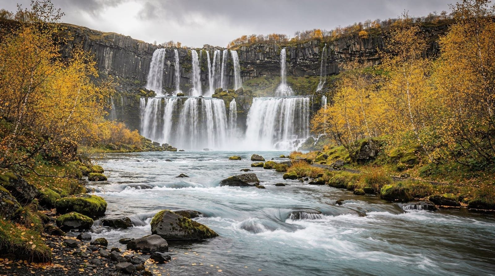
Glymur was Iceland’s highest waterfall until 2011, when surveys confirmed that Morsárfoss in Vatnajökull National Park is taller. At 198 m, Glymur remains the second highest and the most dramatically accessible — reached by a hiking trail that includes a river cave, a log bridge crossing, and a steep climb to a viewpoint perched directly above the drop.
The name Glymur translates as “a loud rumbling sound” — accurate on high-water days in early summer when the Botnsá river is swollen with snowmelt and the falls roar rather than cascade.
The trailhead and access
The trail begins at the end of the Botnsdalur valley, which branches off Hvalfjörður (Whale Fjord) on the south side. Driving the Hvalfjörður tunnel from Reykjavík takes about 50 minutes; driving around the fjord takes 70 minutes and avoids the ISK 2,000–2,500 toll.
From the parking area at the end of the road, a flat trail follows the Botnsá river upstream for approximately 1 km to a small cave where the river runs briefly underground. This cave entrance is the start of the interesting part.
There is no signage beyond basic markers. Download the trail on GaiaGPS or AllTrails beforehand.
The route in detail
Lower valley (0–1 km, flat). The path from the parking area is easy — flat riverbank walking through birch scrub and heath. The river runs clear and cold alongside. In early summer, the birch is in leaf and the valley is green.
Cave section (1 km mark). The trail passes through a short cave beneath a cliff overhang where the river disappears underground temporarily. The cave is not long (30–40 m) but requires crouching in places. A headlamp is helpful but not essential in summer with daylight.
Log bridge (1.2 km mark). Immediately after the cave, a narrow log bridge (typically one sturdy split log with a handrail on one side) spans the river. The crossing is about 4 m over the water. The log can be wet and slippery — cross one person at a time, hold the rail, take your time. This is the most technically challenging section of the hike for most visitors.
When the bridge is in place (typically May to October), this is the standard route. When it is absent, you must wade the river to cross — cold but manageable in summer at knee depth with walking poles.
Western ascent (1.2–2.5 km, 400 m ascent). After crossing, the trail climbs steeply through birch and heath, becoming a loose dirt and scree path on the upper section. This is the hardest part of the hike — sustained, steep, and exposed in places. Trekking poles help significantly on the descent. The views opening behind you over Hvalfjörður increase with every 50 m gained.
Viewpoint above the falls (2.5 km mark). The path levels briefly at the top of the main ascent where the river emerges from a narrow canyon before the drop. The viewpoint above Glymur looks directly down the 198 m face — a vertigo-inducing perspective on a significant amount of water falling through a narrow slot in the basalt. The falls are widest and most powerful in late May and early June when snowmelt is at maximum.
Ridge continuation and eastern descent (2.5–7 km). The full loop continues along the ridge with additional viewpoints showing Glymur from the side, then descends the eastern valley wall back to the river level. The eastern descent is less steep than the western ascent. The loop returns to the car park via the river valley, crossing back to the western side further downstream (no bridge — stepping stones or a simple ford of the shallow lower river).
What to carry
- Waterproof boots (essential — the lower section can be muddy, and wading is possible if the bridge is absent)
- Trekking poles (very helpful on the western ascent and descent)
- Headlamp (for the cave section)
- 1.5 litres of water (no refilling opportunities beyond the cave)
- Waterproof jacket (weather changes quickly on the exposed ridge)
- Gloves (the ridge is exposed to wind even in summer)
Getting there
By car: Route 1 north from Reykjavík, turn onto Route 47 toward Hvalfjörður, continue to Botnsdalur. Total journey: 50–70 minutes depending on route. Google Maps and offline maps both show the trailhead correctly.
By public transport: Limited. Strætó bus service does not directly serve Botnsdalur. A taxi from Reykjavík (one way: ISK 10,000–15,000) or a rental car is required. Some day-tour operators include Glymur on west Iceland circuits.
Combining with other sites: the Snæfellsnes Peninsula (Kirkjufell, Snæfellsjökull National Park) lies further north and west. Glymur fits naturally into a Snæfellsnes road trip as a morning stop. The Borgarfjörður valley (Reykholt medieval church and Hraunfossar waterfall) is 45 minutes north of Glymur and adds complementary interest.
Seasonal conditions
May–June: the log bridge is being reinstalled (usually May). The falls are fullest with snowmelt — spectacular but the western ascent trail can be waterlogged. Early June is the best time for sheer water volume.
July–August: peak season. Trail is dry and clear. Log bridge in place. Busiest period — arrive before 09:00 or after 16:00 to avoid the largest tour groups.
September–October: quieter, good conditions, autumn colours in the birch. The bridge is usually removed by late October.
November–April: bridge absent. Wading or the eastern approach only. Ice possible on upper trails. The falls are still visible but access is significantly more challenging.
Frequently asked questions about the Glymur waterfall hike
What gear do I really need for the log bridge?
Balance and confidence. The log is stable and has a handrail on one side. Trekking poles used as a third contact point increase confidence significantly. Avoid crossing if the log is icy (early spring). If you are not comfortable with exposure over moving water at 4 m, this trail may not suit you.
Is the cave dangerous?
The cave is very short and the ceiling varies from 2 m to less than 1 m. It is dark and the ground can be wet. A headlamp is useful but you can manage without it in summer daylight by ducking through. There are no serious hazards.
Can I see Glymur from the road without hiking?
No. The waterfall is set in a narrow canyon and not visible from any road. You must walk the trail to see it.
How does Glymur compare to other Iceland waterfalls?
Glymur is narrower and more canyon-set than the famous south coast waterfalls (Skógarfoss, Seljalandsfoss). The total height (198 m) exceeds both. The hiking approach adds a dimension that the roadside waterfalls do not have — you earn the view. For visitors doing both the south coast and west Iceland, Glymur is worth the detour.
Is Glymur on any tour itineraries?
A few operators include Glymur on west Iceland day tours. Most Glymur visitors drive independently. It is not on the main Golden Circle routes and is therefore significantly less crowded than south coast waterfalls.
What wildlife might I see on the trail?
Arctic fox are occasionally sighted in Hvalfjörður valley (more common in winter). Common birds include golden plover, ptarmigan, and various waterfowl on the river. The birch woodland in the lower valley supports several small songbird species.
Why Glymur is undervisited
Glymur receives a fraction of the visitor numbers of Iceland’s south coast waterfalls despite being a more technically impressive fall and offering a significantly better hiking experience. The reason is straightforward: it is not on the Ring Road, it is not on the Golden Circle, and it requires a car or taxi to reach rather than being served by direct bus from Reykjavík.
The tourist flow in Iceland is heavily channelled along Route 1 and the Golden Circle. Hvalfjörður, which Glymur occupies the head of, is bypassed by most visitors via the tunnel. This invisibility to the main tourist circuit is precisely what makes Glymur worthwhile — you can arrive mid-July on a Saturday and encounter fewer than 20 people in the valley.
Compare this to Skógarfoss, which may have 500 people in its car park on the same day.
The geology of Glymur and Hvalfjörður
Hvalfjörður is a long, narrow fjord cutting into the Borgarfjörður region northwest of Reykjavík. The fjord walls expose layered basalt lava flows erupted over hundreds of thousands of years — the same type of geology visible in the cliff faces along the south coast. Each layer represents a separate eruption event; the valley has been shaped by the combination of lava flow accumulation and subsequent glacial erosion during the last ice age.
The Botnsá river, which feeds Glymur, drains the highland plateau above. The waterfall itself is located at a hard-rock step in the valley where the river encounters more resistant basalt than the surrounding canyon walls. As the softer rock erodes, the harder step retreats upstream — the waterfall has been retreating headward for thousands of years.
The cave at the base of the trail (where the river briefly disappears underground) formed where the river found a weakness in the basalt layers and cut downward through them. Cave systems like this are common in Iceland’s lava terrain but not always accessible.
Hvalfjörður’s wartime history
Hvalfjörður has an unusual place in 20th-century history as a major Allied naval base in World War II. The fjord’s deep, sheltered waters and proximity to the North Atlantic convoy routes made it an ideal staging point for Allied vessels operating in the early years of the war. Between 1941 and 1945, the fjord hosted hundreds of Allied ships.
Physical evidence of this history remains: the naval base ruins on the north shore of the fjord are visible from the road, and several ammunition bunkers and shore batteries can still be found in the hillsides above Hvalfjörður. None of this is formally developed as a tourist site but local walking routes pass some of the structures.
For visitors interested in combining the Glymur hike with a different historical perspective, driving the full circuit of Hvalfjörður (without the tunnel) takes an additional hour over the tunnel route but passes the main wartime remains on the north shore.
Extending the day: Snæfellsnes and Borgarfjörður
Glymur fits naturally into a west Iceland day trip that continues to the Snæfellsnes Peninsula or the Borgarfjörður valley. Practical combinations:
Glymur + Kirkjufell + Arnarstapi: drive north after Glymur on Route 47, cross Borgarfjörður, and follow Route 54 onto the Snæfellsnes Peninsula. Kirkjufell mountain is 75 minutes from Glymur. Arnarstapi, where the Snæfellsjökull lava meets the sea in dramatic rock arches, is 30 minutes further. Total day: 12 hours from Reykjavík.
Glymur + Reykholt + Hraunfossar: the Borgarfjörður valley east of Glymur contains the medieval farm at Reykholt where the 13th-century scholar Snorri Sturluson lived and wrote the Prose Edda. Nearby, the Hraunfossar lava waterfalls (water emerging from a 1 km stretch of lava rock) are one of Iceland’s most unusual hydrological features. This combination adds historical and geological interest to a west Iceland day.
What the trail looks like in different seasons
Early May: the log bridge may be reinstalling after winter. The birch is not yet in leaf — the lower valley looks grey and skeletal. The falls are often at maximum flow from winter snowmelt. Bring micro-crampons; the upper section may have icy patches.
June: birch in full leaf, the valley is green, and the falls are still strong. The log bridge is in place. Trail surface can be muddy after rain. Best month for the combination of full water flow and pleasant walking conditions.
July–August: dry conditions (usually), steady but reduced flow in the falls, the most hikers. Arrive before 09:00 or after 17:00 on weekends for quieter conditions.
September–October: autumn colour on the birch makes this one of the most atmospheric times to visit. Significantly fewer people. The bridge is usually still in place until late October. Occasional frost at the upper viewpoint.
November–April: bridge removed. Icy upper sections. The falls are partially frozen in cold winters. Possible but requires experience and appropriate gear.
Practical notes from recent visitor accounts
The most common issues reported by hikers who visit Glymur:
Slipping on the log bridge: the log can be wet even in dry weather from spray. Cross slowly, one person at a time, hold the rail on both hands if there is one available on both sides.
Getting confused on the upper section: above the viewpoint, the trail splits toward the canyon head and the eastern descent. If continuing the loop, follow the cairns eastward along the ridge rather than following the canyon upstream (which leads to more difficult terrain).
Arriving at low bridge season: the bridge is removed between roughly October/November and April/May. Check recent hiking reports (Iceland hiking Facebook groups or local guide company social media) before making a specific trip to Glymur in spring.
Parking on busy weekends: the Botnsdalur trailhead parking area holds approximately 20–30 vehicles. On a busy July Saturday, it can fill by 10:00. The roadside shoulder has informal overflow parking for a short distance.
Glymur and west Iceland: building a full day
The Glymur hike takes 3–4 hours. Adding nearby destinations creates a full west Iceland day without long drives:
Option A — Glymur + Reykholt + Hraunfossar (170 km total from Reykjavík):
- Glymur hike: 3–4 hours from 08:30
- Drive north on Route 47 to Borgarnes and east on Route 50 toward Reykholt
- Reykholt medieval farm (Snorrastofa visitor centre): 45 minutes. The 13th-century historian Snorri Sturluson lived and died here; his outdoor hot pool (Snorralaug) is the oldest identifiable structure associated with a named Icelander
- Hraunfossar and Barnafoss waterfalls: 20 km from Reykholt. Hraunfossar is a 900 m-wide spring waterfall emerging directly from a lava field — one of Iceland’s most unusual hydrological features
- Return to Reykjavík via Route 1: 1.5 hours
Option B — Glymur + Snæfellsnes Peninsula (230 km total from Reykjavík):
- Glymur hike: morning departure
- Drive Route 47 north to Borgarnes, then Route 54 onto the Snæfellsnes Peninsula
- Kirkjufell mountain and waterfall: 90 minutes on the peninsula
- Snæfellsjökull National Park coastal walk at Arnarstapi or Hellnar
- Return via Route 54/1: 2 hours
These combinations avoid retracing the same road twice and cover significant terrain efficiently.
The technical challenge of the upper section
The western trail above the log bridge is one of the steeper maintained hiking routes within an hour of Reykjavík. The gradient in the middle section (1.5–2.5 km after the bridge) reaches approximately 35–40 degrees on the loose dirt and scree. In dry conditions, this is manageable for fit walkers using standard hiking boots. In wet conditions, the loose surface becomes significantly more challenging.
Specific warnings:
Loose scree descent: the descent on the same western trail is harder than the ascent for some hikers. The loose surface slides underfoot on the way down. Trekking poles provide critical stability. Take small steps, keep your weight centred, and do not rush.
Exposure near the top: the viewpoint above the falls at 2.5 km has minimal barrier between the hiking path and the canyon edge. The drop is significant. Do not approach the edge; the view is adequate from the trail.
The eastern descent: the trail connecting the ridge viewpoints to the eastern descent is faint in places. Follow the cairns carefully; the canyon rim on the right (if descending east) is not fenced. A GPS track downloaded in advance eliminates navigation uncertainty.
Waterfall science: why Glymur is so narrow
The shape of Glymur — extremely tall, very narrow, dropping through a slot canyon — reflects the specific geology of the Botnsá river gorge. The river has cut down through a series of hard basalt layers, and the narrowness of the canyon indicates the rock has resisted lateral erosion better than vertical incision.
At the top of the falls, the river emerges from a shallow valley and makes a sharp turn before dropping into the canyon. This geometry — a turn preceding a vertical drop — is common in Iceland’s basalt lava terrain and is responsible for the dramatic approach perspective from the upper trail.
The canyon walls below Glymur are estimated to be approximately 12,000–15,000 years old — formed as the Botnsá cut progressively deeper after the last ice age glaciers retreated. The exposed rock faces reveal the layered lava stratigraphy clearly, with each layer representing a separate eruption event.
Accessibility for different ability levels
Accessible by wheelchair: the flat lower valley (first 0.5 km) is accessible for wheelchair users on a firm day. The log bridge and all subsequent trail sections are not wheelchair accessible.
Accessible for older hikers: the lower valley to the cave entrance (1 km) is manageable for most fit older adults. The log bridge crossing requires balance confidence. The western ascent above the bridge is the limiting factor — most hikers over 65 find the steep section manageable if taken slowly.
Accessible for very young children: children under 8 can walk the lower valley. The cave section (low ceiling) requires carrying very young children. The log bridge and upper section are not suitable for children under 10 without direct parental assistance throughout.
Comparison with other west Iceland waterfalls
The Öxará river waterfalls at Þingvellir are flat and accessible but modest in scale. Glymur is incomparably more dramatic. The Hraunfossar falls in Borgarfjörður are unusual rather than tall — wide spring emergence rather than vertical drop. Glymur’s combination of height, canyon setting, and hiking approach makes it the definitive west Iceland waterfall experience.
The south coast waterfalls (Seljalandsfoss, Skógarfoss) are wider and more photogenic from road level but Glymur exceeds both in total height. For visitors doing both west and south Iceland, the comparison is worth making directly — each region’s waterfall has a distinct character, and the hiking approach to Glymur gives it a different category of experience.
Frequently asked questions about Glymur waterfall hike
Is the Glymur trail accessible year-round?
Yes, but the log bridge is removed in winter (typically November to May) to prevent damage from ice and floods. When the bridge is absent, the only crossing is a wade through the cold river — feasible in summer conditions. The trail is most accessible May to October.How far is Glymur from Reykjavík?
About 55 km from Reykjavík city centre — approximately 50 minutes by car via the Hvalfjörður tunnel (toll: ISK 2,000–2,500) or about 70 minutes the free route around the fjord.Is there a fee to hike Glymur?
No trail entry fee. Parking at the Botnsdalur trailhead is free. There are no visitor facilities at the trailhead — no toilets, no café.Can I hike Glymur without crossing the log bridge?
The standard loop uses the log bridge on the approach and exits the valley on the eastern side. If the bridge is absent (winter/spring), you can still hike the eastern trail up to the viewpoint above the falls — this approach does not require crossing the river.What is the best viewpoint at Glymur?
The viewpoint on the western trail directly above the falls — at the top of the steep ascent — gives the clearest top-down view of the 198 m drop. The eastern ridge viewpoints show the falls in profile against the valley. Both are worth visiting if you do the full loop.Is Glymur suitable for children?
The lower valley section is manageable for older children (10+). The log bridge requires balance and confidence; the upper steep section is exposed. Not recommended for young children or anyone uncomfortable with heights on narrow paths.
Top experiences
Best-rated activities across GetYourGuide and Viator.

Sólheimajökull Glacier Hike – Adventure in a Small Group
- Viator

Blue Ice Discovery – Guided Glacier Hike from Skaftafell
- Viator

Glacier Hike from Skaftafell - Extra Small Group
- Viator

Sólheimajökull Glacier Hike - Small Group Blue Ice Adventure
- Viator

Skaftafell Glacier Hike 3-Hour Small Group Tour
- Viator

Solheimajokull Glacier 3-Hour Small-Group Hike
- Viator