Best day hikes in Iceland — 12 routes across all skill levels
What are the best day hikes in Iceland for first-timers?
For first-timers: the Reykjadalur hot spring hike (6 km return, easy) is the most accessible. Glymur waterfall (7 km loop, moderate) is the most dramatic for the effort. Skógarfoss waterfall canyon (8 km one way, moderate) offers 20+ waterfalls. All three are reachable from Reykjavík without a 4WD.
Iceland’s day hikes range from flat waterfall walks that take 90 minutes to full alpine crossings that challenge experienced mountaineers. This guide covers twelve of the best, ranked honestly by difficulty, with real trail distances, ascent figures, transport options, and notes on what can go wrong.
Quick reference table
| Trail | Distance | Ascent | Difficulty | Region |
|---|---|---|---|---|
| Reykjadalur hot spring | 6 km return | 200 m | Easy | South |
| Þingvellir rift walk | 4 km loop | 50 m | Easy | South |
| Svartifoss waterfall | 5 km return | 150 m | Easy | South-East |
| Glymur waterfall | 7 km loop | 400 m | Moderate | West |
| Kirkjufell circuit | 4 km loop | 200 m | Moderate | West |
| Skógarfoss canyon | 8 km one way | 500 m | Moderate | South |
| Brennisteinsalda loop | 4 km loop | 300 m | Moderate | Highlands |
| Valahnúkur viewpoint | 3 km return | 150 m | Moderate | Highlands |
| Bláhnúkur peak | 7 km return | 500 m | Moderate-hard | Highlands |
| Fimmvörðuháls pass | 24 km one way | 900 m | Challenging | South |
| Tindfjöll ridge | 7 km return | 400 m | Challenging | Highlands |
| Drangey island circuit | 4 km loop | 300 m | Hard | North |
Easy hikes
Reykjadalur hot spring hike
Distance: 6 km return. Ascent: 200 m. Time: 2.5–3.5 hours plus bathing. Trailhead: Hveragerði (45 min from Reykjavík by car or bus).
The most popular easy hike in Iceland ends at a free geothermal bathing river. The trail follows a geothermal valley past steam vents and brightly coloured algae before reaching the hot spring at the top. No technical difficulty; muddy in wet weather. Full trail guide.
Þingvellir rift valley walk
Distance: 4–8 km depending on route. Ascent: 50 m. Time: 1.5–3 hours. Trailhead: Þingvellir National Park visitor centre (40 min from Reykjavík).
Flat walking through the valley where the North American and Eurasian tectonic plates are pulling apart. The Almannagjá gorge, Öxará river, and Þingvallavatn lake are all easily accessible. Excellent for families with young children. Part of the Golden Circle day trip.
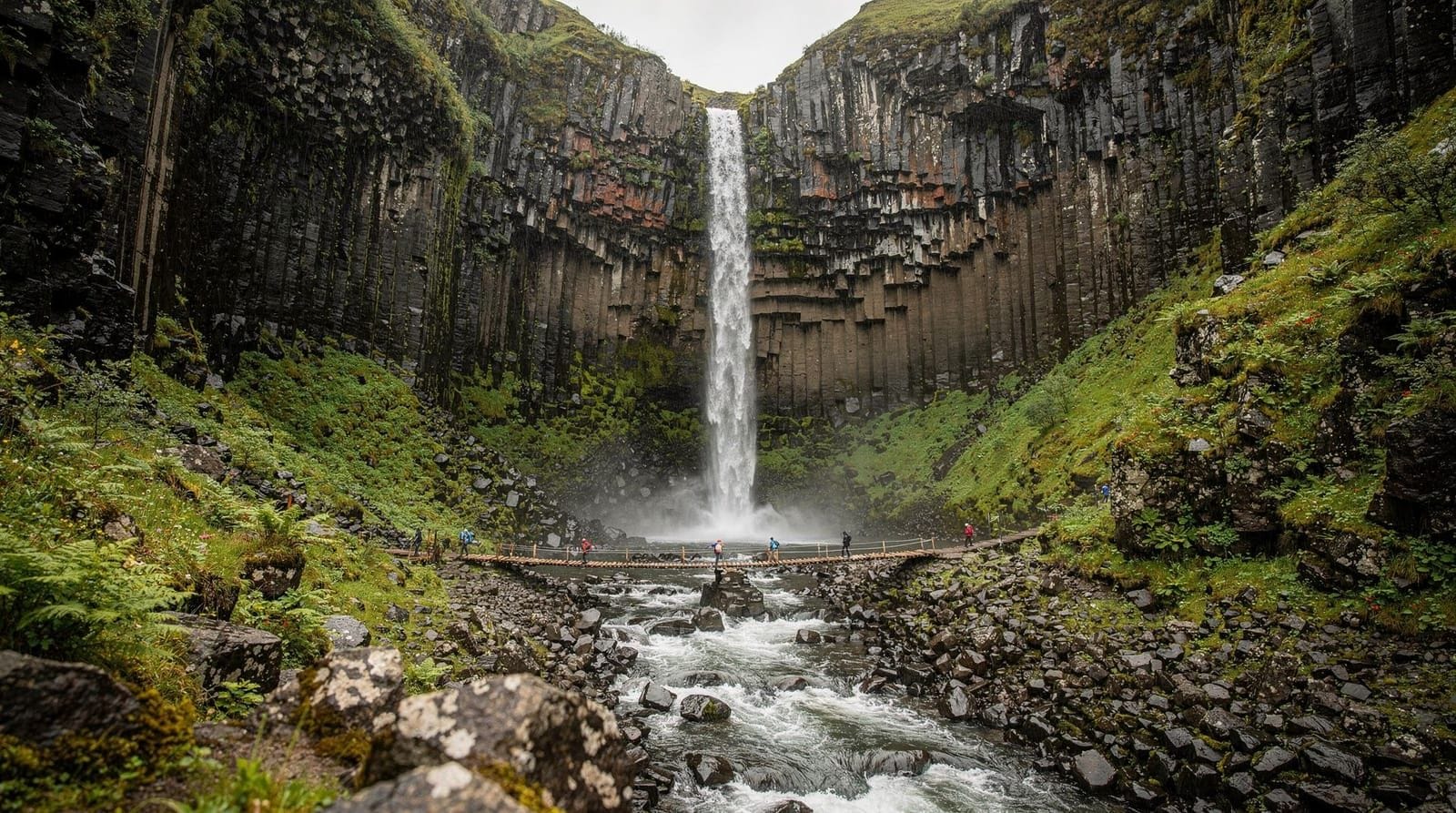
Svartifoss and Skaftafell trails
Distance: 5 km return to Svartifoss. Ascent: 150 m. Time: 2–2.5 hours. Trailhead: Skaftafell Visitor Centre in Vatnajökull National Park.
Svartifoss is a waterfall that drops over a curtain of hexagonal basalt columns — the most geometrically striking waterfall in Iceland. The trail from the visitor centre is well-maintained and suitable for all fitness levels. Combine with the flat glacier lagoon walk along Skeiðarársandur if time permits.
Moderate hikes
Glymur waterfall hike
Distance: 7 km loop (or 4.5 km return to the top). Ascent: 400 m. Time: 3–4 hours. Trailhead: Botnsdalur, near Hvalfjörður (50 min from Reykjavík by car).
Glymur is Iceland’s second highest waterfall at 198 m. The trail crosses the Botnsá river on a log and climbs the valley wall to a viewpoint directly above the falls. Dramatic and seldom described accurately in glossy guidebooks — the approach is genuinely steep and involves a cave tunnel at the base. See the Glymur waterfall guide for logistics.
Kirkjufell circuit
Distance: 4 km loop. Ascent: 200 m. Time: 2–2.5 hours. Trailhead: Grundarfjörður, Snæfellsnes Peninsula (2 hrs from Reykjavík).
Kirkjufell is the most photographed mountain in Iceland — a distinctive cone that rises sharply from the Snæfellsnes shoreline. The circuit trail goes around the base with dramatic views from all angles. The summit (463 m) is a separate scramble requiring confidence on steep terrain; the circuit loop itself is moderate.
Skógarfoss canyon
Distance: 8 km one way. Ascent: 500 m. Time: 3–4 hours. Trailhead: Skógar waterfall, south coast (2.5 hrs from Reykjavík by bus).
From the base of Skógarfoss, a staircase alongside the waterfall launches you into a canyon hike past 20+ cataracts. This is the lower section of the Fimmvörðuháls route. Turn around at the canyon head (or at Fimmvörðuskáli hut if it is staffed) for a 7–8 km return hike. Probably the best waterfall hiking route in Iceland for the variety of falls encountered.
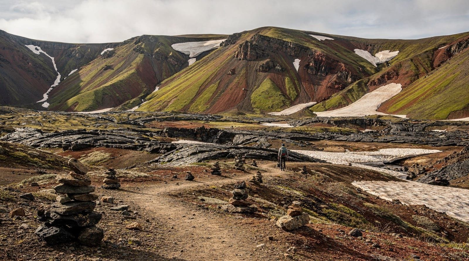
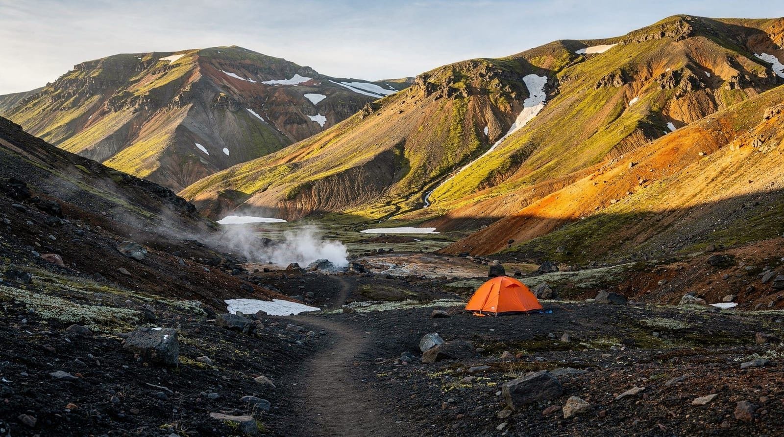
Brennisteinsalda loop (Landmannalaugar)
Distance: 4 km loop. Ascent: 300 m. Time: 2–2.5 hours. Trailhead: Landmannalaugar (requires highland bus or 4WD).
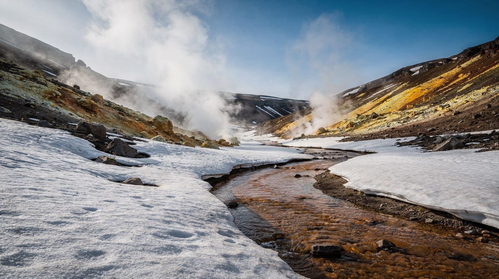
The most accessible hike from the Landmannalaugar trailhead circuits the vivid rhyolite volcano Brennisteinsalda. The colour range — green, yellow, ochre, pink — is unlike any other terrain in Iceland. Active steam vents and obsidian patches add geological interest. Best combined with the hot spring bathing at the base. Full context in the Landmannalaugar hiking guide.
Valahnúkur viewpoint (Þórsmörk)
Distance: 3 km return. Ascent: 150 m. Time: 1.5–2 hours. Trailhead: Langidalur hut, Þórsmörk (requires super-jeep bus).
Short but spectacular. The ridge above Þórsmörk gives a 360-degree view including all three surrounding glaciers (Eyjafjallajökull, Mýrdalsjökull, Tindfjallajökull) and the birch valley below. Most visitors to Þórsmörk do this hike. Access requires the super-jeep highland bus.
Moderate-challenging hikes
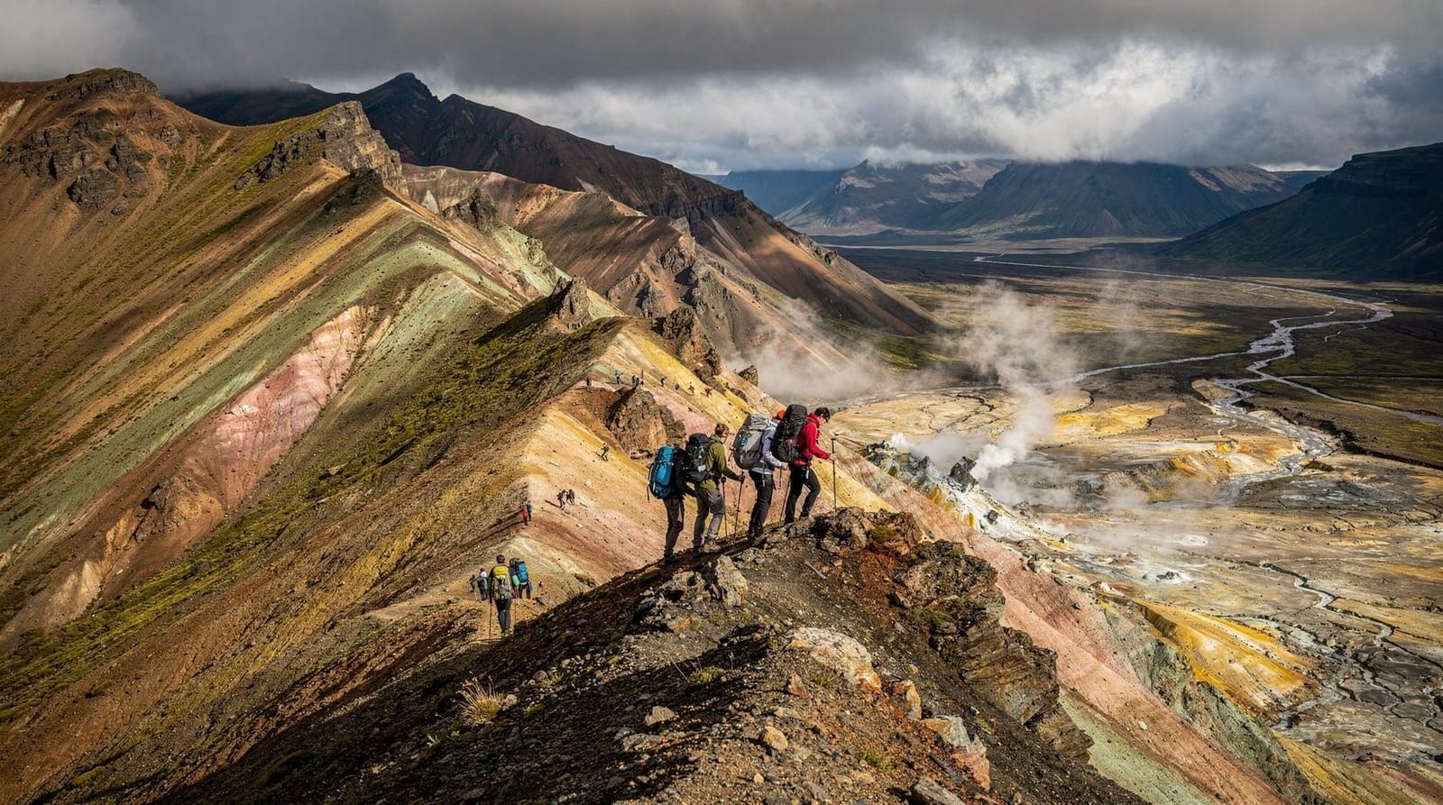
Bláhnúkur peak (Landmannalaugar)
Distance: 7 km return. Ascent: 500 m. Time: 3.5–4.5 hours. Trailhead: Landmannalaugar (requires highland bus or 4WD).
The tallest readily accessible peak from Landmannalaugar at 943 m, Bláhnúkur (“Blue Peak”) gives the best panoramic view in the Fjallabak area. The upper ridge involves loose obsidian rock — good footwear is essential. Not technical, but sustained steepness. The name refers to the blue-grey obsidian that makes up much of the summit area.
Challenging hikes
Fimmvörðuháls pass crossing
Distance: 24 km one way. Ascent: 900 m (Skógar side). Time: 8–10 hours. Trailhead: Skógar or Þórsmörk.
The most demanding single-day hike in Iceland crosses the volcanic pass between Skógarfoss on the coast and Þórsmörk in the highlands. Full route description in the Fimmvörðuháls guide. Requires good fitness, full waterproof gear, and crampons/microspikes before late July.
Planning across multiple hikes
If you have a week and want a hiking focus:
Days 1–2: Reykjadalur and Glymur from Reykjavík base
Day 3: Þingvellir + south to Skógar; overnight near Skógar
Day 4: Skógarfoss canyon (lower section)
Day 5: Bus to Landmannalaugar; overnight at FÍ hut
Day 6: Bláhnúkur or Brennisteinsalda loop
Day 7: Return to Reykjavík via highland bus
Alternatively, combine Kirkjufell and the Snæfellsnes Peninsula trails with a 2-day loop on Snæfellsnes.
Honest notes on common mistakes
Wearing trainers on highland trails. Trainers manage the lower Reykjadalur trail in dry conditions. They become dangerous on wet obsidian (slippery), loose lava scree, or river crossings. Waterproof hiking boots with ankle support are the correct footwear for Bláhnúkur, Fimmvörðuháls, and anything involving a river crossing.
Underestimating weather change speed. A sunny morning at sea level does not mean the pass is clear. Check the Veðurstofa (vedur.is) highland forecast specifically — not just the Reykjavík forecast.
Not downloading offline maps. The cell coverage on many Iceland trails is unreliable. Download Gaia GPS, AllTrails, or maps.me maps for your specific hike before leaving your accommodation.
Starting too late. Highland buses typically arrive at trailheads around 11:00–13:00. This leaves limited time for longer day hikes before the return bus departs. Check departure times carefully and if necessary, stay overnight rather than rushing.
Frequently asked questions about Iceland day hikes
Are all the trails listed here open year-round?
Reykjadalur, Þingvellir, and coastal trails are year-round. Highland trails (Landmannalaugar, Þórsmörk, Fimmvörðuháls) open mid-June to mid-September. Glymur and Kirkjufell are accessible spring to autumn with appropriate gear.
Do I need a trail permit for any of these hikes?
No trail permits are required for public hiking in Iceland. Camping within national parks requires designated campsites. Register your hiking plan at safetravel.is for any highland hike.
How do I find a trailhead without getting lost driving?
Use what3words, Google Maps (which now includes Icelandic trailheads), or download GaiaGPS with offline maps. Highway 1 (Ring Road) and numbered roads are easy to navigate; F-roads require specific GPS or 4x4 guidance.
What are the lightest-footprint hiking routes?
Þingvellir rift walks and the Skaftafell maintained trails have the most infrastructure to handle visitor numbers. More remote trails like Markarfljótsgljúfur canyon and Tindfjöll ridge have minimal infrastructure and require careful Leave No Trace practice.
Gear notes for Iceland day hikes
Specific gear questions come up repeatedly for Iceland day hiking:
Boots vs trail runners: most Iceland day hikes except the flat Þingvellir and Jökulsárlón walks benefit from waterproof boots with ankle support. Trail runners manage summer conditions on dry days but fail at river crossings and in sustained rain. The Salomon X Ultra and Scarpa Kailash are popular choices among Iceland regulars.
Waterproof jacket: this is the single most important item. A shower-resistant shell from a European high street retailer will not keep you dry in an Iceland squall. Look for jackets with at least 20,000 mm hydrostatic head and taped seams.
Gaiters: optional for most trails. Useful for the Bláhnúkur scree approach and any river crossing route. Short gaiters that keep debris out of boots are more practical than full-length gaiters for day hiking.
Poles: strongly recommended for any hike with significant descent, river crossings, or loose terrain. Foldable poles (BD Distance Z, Leki Micro Trail) pack easily in hand luggage.
Sun protection: Iceland’s long summer days produce UV exposure equivalent to alpine environments. SPF 50 is appropriate on snow and ice sections (Fimmvörðuháls pass, Bláhnúkur summit). On valley trails, SPF 30 is sufficient.
Safety overview for Iceland day hikes
The ICE-SAR (Icelandic Association for Search and Rescue) handles around 1,500 rescue operations per year. A significant proportion involve day hikers rather than multi-day trekkers — people who underestimated weather, ran out of daylight, or got lost on trails without offline maps.
Practical safety checklist for any Iceland day hike:
- Check the weather forecast at vedur.is within 24 hours of departure (not on the day of planning)
- Download offline maps for your specific route before leaving accommodation
- Tell someone your plan and expected return time
- Carry emergency contact: phone fully charged, ICE-SAR number saved (1-1-2)
- Register at safetravel.is for any highland or remote hike
- Carry a basic first aid kit on any hike over 10 km
The single biggest cause of preventable rescues is starting too late and running out of daylight. In June and July, this risk is theoretically eliminated by the midnight sun, but in August and September the window narrows quickly — sunset is at 21:00 in early August and 18:00 by late September.
Iceland hiking costs summary
Day hiking in Iceland is largely free. The costs involved:
Access: most day hikes have no entry fee. Parking fees apply at popular trailheads: Skógar ISK 1,000, Reykjadalur ISK 800–1,000, Glymur free, Landmannalaugar included in highland bus fare.
Transport: highland bus to Landmannalaugar ISK 9,000–12,000 return. Strætó bus to Hveragerði (for Reykjadalur) ISK 500–700 each way. Car hire for self-drive access: add to your overall rental cost.
Guided hikes: day guided hikes with transport typically cost ISK 15,000–25,000 per person for 4–8 hours including transport. Shorter guided hikes without transport: ISK 6,000–12,000.
Food: no on-trail food sales except at Landmannalaugar (basic snacks). Pack your own lunch; this is the cheapest meal option in Iceland regardless.
The low monetary cost of Iceland hiking is why it attracts independent travellers who find the commercial side of Iceland’s tourism economy expensive. A full day on the Bláhnúkur or Fimmvörðuháls lower section with packed food and a highland bus seat costs under ISK 15,000 (EUR 97) total.
Responsible hiking in Iceland’s highlands
Iceland’s geologic terrain is among the most fragile in the world. The moss and vegetation covering lava fields, highland plateaus, and valley floors takes decades to recover from trampling damage. The bright green vegetated areas around Þórsmörk, Landmannalaugar, and Þingvellir are living soil systems rather than grass — walking off trail creates paths that persist for years.
Practical guidelines:
- Stay on marked trails; never cut switchbacks
- Do not collect volcanic rock, flowers, or moss
- Bury toilet waste 100 m from any water source; pack out all toilet paper
- In national parks (Þingvellir, Vatnajökull, Snæfellsnes), no wild camping
- Do not approach steam vents or walk on coloured geothermal soil
- Pack out all rubbish; waste bins at trailheads are for day visitors to use on return
The Icelandic Environment Agency (ust.is) publishes guidelines for sustainable hiking. The Leave No Trace principles apply throughout the country’s national parks and nature reserves.
12 hikes compared: the honest summary
For visitors trying to choose among these options given limited time, a direct comparison:
Most visually dramatic per hour of effort: Valahnúkur (Þórsmörk) — 90 minutes return, 360-degree glacier view. Requires super-jeep bus access but the effort-to-payoff ratio is excellent.
Best for families with children under 8: Þingvellir rift walk — flat, free, accessible, with a geological story that translates to all ages.
Best single-day challenge: Fimmvörðuháls crossing — 24 km, 900 m ascent, volcanic pass between two glaciers. Iceland’s definitive difficult day hike.
Best near Reykjavík without a car: Reykjadalur — 40 minutes by bus, free bathing at the end, clear trail.
Best waterfall variety: Skógarfoss canyon lower section — 20+ waterfalls in 8 km, one of the most varied waterfall hiking routes in Iceland.
Most underrated: Glymur — Iceland’s second highest waterfall, barely promoted, very quiet compared to south coast equivalents, genuine hiking challenge with log bridge crossing.
Best for geological interest: Brennisteinsalda loop (Landmannalaugar) — the rhyolite colour range here is available nowhere else in Iceland and the steam vents are genuinely active.
Best for photographers: Kirkjufell circuit — the mountain-waterfall composition is Iceland’s most photographed landscape for good reason, and the circuit gives multiple angles.
Getting hike-ready: what to do before arriving in Iceland
If Iceland hiking is the main purpose of your trip, 4–6 weeks of preparation makes a significant difference:
Cardiovascular fitness: walk or run 3–4 times per week with at least one session involving sustained uphill (stair machine, hill, or treadmill incline). The Bláhnúkur ascent is 500 m gain over 3.5 km — equivalent to walking uphill for 80 minutes continuously.
Boot break-in: new hiking boots cause blisters on long hikes. Wear your Iceland hiking boots on at least 5 significant walks (8+ km each) before departure.
Pack training: carry your intended day pack weight on training hikes. If you plan to carry 8 kg (water, food, spare layers, rain gear), train with that weight.
Navigation practice: download Gaia GPS, load your Iceland hike areas offline, and practice reading the map. If you have never used an offline mapping app, a confusing Highland plateau with low cloud visibility is not the place to learn.
Weather tolerance: if you normally avoid outdoor activities in rain, practice walking in poor weather before Iceland. The ability to enjoy being outdoors when it is wet and cold — rather than being miserable — is the most useful psychological preparation for Iceland hiking.
Frequently asked questions about Best day hikes in Iceland
Which Iceland day hikes require a 4WD or highland bus?
Landmannalaugar hikes (Brennisteinsalda, Bláhnúkur) and Kerlingarfjöll require F-road access by 4WD or highland bus. Þórsmörk day visits also require super-jeep transport. All other hikes in this guide are reachable by standard car or public bus.What is the most spectacular day hike in Iceland?
Fimmvörðuháls (24 km, 900 m ascent) is the most dramatically varied single-day hike — crossing a volcano pass between two glaciers through the 2010 eruption craters. But it requires full alpine fitness and a long day. For non-specialists, Glymur or Skógarfoss canyon offers comparable scenery at lower commitment.Are Iceland hiking trails clearly marked?
Coastal and popular trails (Glymur, Reykjadalur, Skaftafell area) are well marked with cairns or paint. Highland routes can become unmarked in cloud or snow. Always download offline maps before any hike more remote than the main tourist trails.Can I hike in Iceland in October?
Coastal and low-altitude trails are walkable in October with appropriate gear. Highland routes (Landmannalaugar, Þórsmörk, Fimmvörðuháls) typically close by mid-September. In October, expect cold temperatures, possible snow at altitude, and limited daylight.Is there a fee to hike in Iceland's national parks?
Hiking in national parks (Þingvellir, Vatnajökull, Snæfellsnes) is free. Parking fees apply at popular trailheads (ISK 800–1,500 per car). Some glacier hikes within national parks are guided-only and have tour fees.
Top experiences
Bookable activities with verified prices and instant confirmation on GetYourGuide.

Top experiences
Best-rated activities across GetYourGuide and Viator.

Sólheimajökull Glacier Hike – Adventure in a Small Group
- Viator

Blue Ice Discovery – Guided Glacier Hike from Skaftafell
- Viator

Glacier Hike from Skaftafell - Extra Small Group
- Viator

Sólheimajökull Glacier Hike - Small Group Blue Ice Adventure
- Viator

Skaftafell Glacier Hike 3-Hour Small Group Tour
- Viator

Solheimajokull Glacier 3-Hour Small-Group Hike
- Viator