Fimmvörðuháls hike — crossing the volcano pass between Þórsmörk and Skógar
Vik: Thorsmork guided day hike super jeep
How long is the Fimmvörðuháls hike and when does it open?
The Fimmvörðuháls trail is 24 km one-way, usually walked Skógar to Þórsmörk in 8–10 hours. The high pass typically clears of snow by early July. Starting from Skógar (coast side) is safer as the lower section stays ice-free longer.
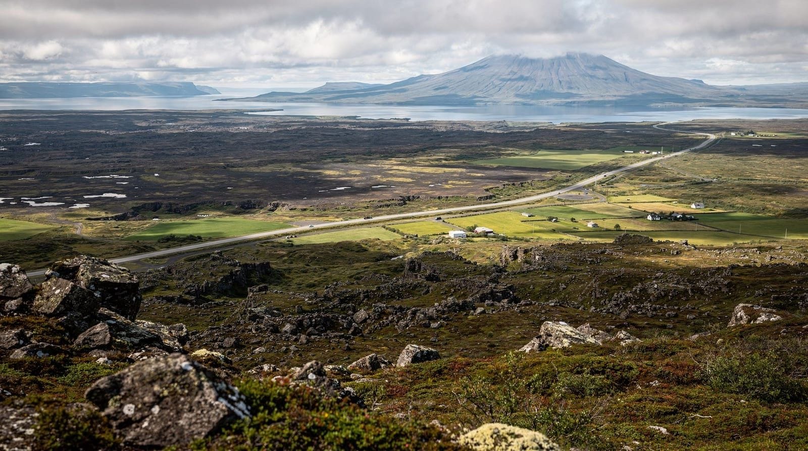
The Fimmvörðuháls trail is the day hike between Iceland’s two most famous hiker destinations: Skógarfoss waterfall on the south coast and the birch valley of Þórsmörk. The 24 km route crosses a high mountain pass at 1,067 m, threads between the icecaps of Eyjafjallajökull and Mýrdalsjökull, and traverses the raw lava field created by the Eyjafjallajökull eruption in April 2010.
It is not an easy day. The ascent from Skógar is relentless. The pass is genuinely exposed to weather. But no other single-day walk in Iceland combines waterfalls, glaciers, volcanic craters, and a valley finish quite like this one.
The route in four stages
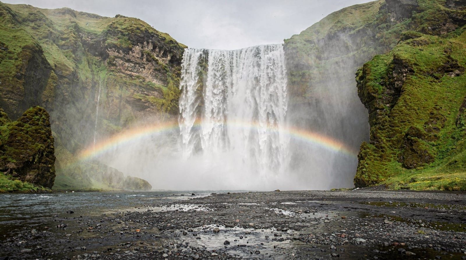
Stage 1: Skógar to Skógarfoss base (0–2 km). The trail begins beside Skógarfoss waterfall, one of Iceland’s most-visited sites. While tourists photograph the cascade from the platform, hikers take the staircase alongside and climb immediately above the falls. From the top, the view back over the south coast and out to sea is the first of many payoffs.
Stage 2: The waterfall canyon (2–8 km, 900 m ascent). The Skógar River runs from the Eyjafjallajökull icecap down a steep canyon lined with more than 20 cataracts. The trail follows the river upstream, crossing several times on footbridges. The waterfalls range from delicate single-strand falls to thundering wide drops. The path is well-marked but the 900 m climb over 8 km is unrelenting — this stage takes most hikers 2.5–3.5 hours.
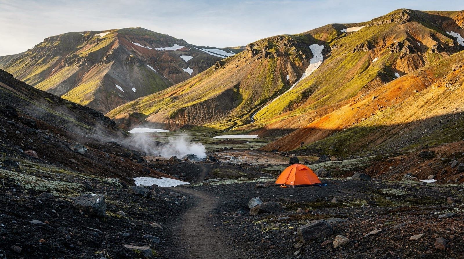
Stage 3: The pass and the craters (8–17 km). The terrain changes dramatically above 900 m — grass and heath give way to snow (in June/July) and then black lava. The two craters from the 2010 eruption, Magni and Móði, sit at roughly 1,000 m elevation. Both can be approached — the rock inside is still vivid red and orange where oxidisation has set in. Walking between the crater walls gives a rare sense of being on a very recently active volcano.
The highest point of the pass is around 1,067 m. On a clear day you look directly along the flank of Eyjafjallajökull to the left and Mýrdalsjökull to the right. Visibility of 40–50 km on both sides is common in summer.
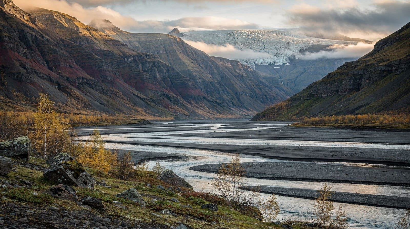
Stage 4: Descent to Þórsmörk (17–24 km). The descent from the pass into Þórsmörk drops through loose volcanic scree and then into increasingly dense birch woodland. The temperature rises noticeably; the valley floor is sheltered and often 5–8°C warmer than the pass. Arriving at the Langidalur hut complex after a full day on the mountain feels genuinely satisfying.
Getting to Skógar and back from Þórsmörk
Skógar sits on the Ring Road (Route 1) approximately 150 km from Reykjavík. Buses from Reykjavík BSÍ run to Skógar in roughly 2.5 hours. Strætó and Reykjavík Excursions both serve this route.
From Þórsmörk, scheduled buses back to Reykjavík run via Seljalandsfoss — journey time around 3 hours. Buses use high-clearance coaches for the final river-crossing section into the valley. Normal hire cars cannot reach Þórsmörk.
Logistics tip: if you want to do the hike in one day from Reykjavík, take the earliest bus to Skógar (departing around 08:00), hike by 09:00, and aim to reach Þórsmörk by 19:00 to catch the afternoon bus. This leaves minimal buffer — staying overnight at Þórsmörk or Skógar is significantly more relaxed.
Weather and seasonal considerations
The pass is above the cloud inversion line on most days. Clear weather at sea level does not guarantee a clear pass — low cloud can close in rapidly and reduce visibility to 20 m. Check the Veðurstofa (Icelandic Met Office) 72-hour forecast specifically for Fimmvörðuháls, not just the south coast.
Open season: typically mid-July to mid-September for reliable conditions. Early July is feasible but the pass section often has compacted ice requiring microspikes. September brings early snowfall risk.
Temperature at the pass: plan for 0–5°C at the top even in August, with wind chill making it feel colder. A waterproof jacket, insulating mid-layer, hat, and gloves are not optional.
Rain: the south coast of Iceland receives substantial rainfall. The waterfalls are best seen in partial cloud (the light is softer and spray more dramatic), but full rain on the exposed pass is miserable. The hike can be paused at the staffed Fimmvörðuskáli hut if conditions deteriorate badly.
Guided Þórsmörk day tours from the south coast include a super-jeep transfer into the valley and a guided hike through the terrain around the valley — a good option if you want local expertise without committing to the full Fimmvörðuháls crossing.
The Laugavegur connection
Fimmvörðuháls is often walked as the final day of an extended Laugavegur trek. The standard 4-day Laugavegur runs Landmannalaugar to Þórsmörk; adding Fimmvörðuháls creates a 5-day, 79 km route that ends at Skógar on the coast. This combination represents the longest and most varied continuous highland traverse available without a guide.
From Skógar, walkers can then catch a bus back to Reykjavík along the south coast — optionally stopping at Seljalandsfoss (15 minutes from the road) on the way back.
What to carry
Pack for a full alpine day even in summer. The essentials:
- Waterproof jacket and trousers
- Insulating mid-layer (fleece or down)
- Hat and gloves
- Microspikes or light crampons (for June/early July)
- Trekking poles (critical on the descent)
- 2 litres of water (refillable from clean streams until the lava section)
- High-calorie food for 8–10 hours
- Headlamp (in case of delay on long summer days)
- Emergency bivvy bag
Boots should be waterproof and broken in — the terrain switches between muddy path, loose volcanic rock, ice, and stream crossings.
Practical alternatives if the full route is too much
The lower waterfall section of Fimmvörðuháls — from Skógar to the top of the canyon (roughly 8 km and 3 hours return) — is one of the best waterfall hikes in Iceland on its own merits. You can turn around before the snow line and still see 20+ waterfalls without the exposure of the high pass.
Alternatively, the best day hikes in Iceland guide lists several less committing options for hikers who want variety without the Fimmvörðuháls intensity.
Frequently asked questions about the Fimmvörðuháls hike
How fit do I need to be for Fimmvörðuháls?
Good aerobic fitness is required — 900 m of ascent in the first 8 km is equivalent to the steeper trails in the Alps. If you can walk uphill for 3 hours without stopping, you can manage the ascent. The full 24 km demands all-day endurance.
Are there toilets along the route?
Basic toilet facilities exist at the Fimmvörðuskáli hut (staffed mid-July to August). Elsewhere, pack out toilet paper and bury waste well away from water sources. Follow Leave No Trace principles strictly — this is an environmentally sensitive area.
Can I camp along the route?
Free camping is not permitted in the Þórsmörk nature reserve. Designated camping exists at the hut sites. On the pass section, wild camping is technically possible but exposed and cold.
Is Fimmvörðuháls suitable for children?
Only for experienced teenage hikers (14+) with prior multi-hour mountain experience. The total distance, exposed pass, and potential ice make it unsuitable for younger children.
What if I get stuck on the pass?
The Fimmvörðuskáli emergency hut provides basic shelter. Register your hiking plan at safetravel.is before departure. In serious trouble, call 112.
Can I hire a guide for Fimmvörðuháls?
Yes — several Reykjavík operators offer guided crossings, typically as part of a Þórsmörk package with super-jeep return. Guides assess river and ice conditions on the day and carry group emergency equipment.
Geology of the route: what you are walking through
The Fimmvörðuháls hike is a compact geological time capsule. The lower section follows the Skógar river, which has carved its canyon through stacked layers of basalt lava flows erupted over thousands of years. Each waterfall you pass marks a layer boundary where harder rock resists erosion slightly longer than the surrounding material.
At 900 m elevation, you leave the layered basalt and enter the Eyjafjallajökull volcanic system. The 2010 eruption deposited new material over the older glacial moraine and created the Magni and Móði craters — young enough that the lava is still fragmented and unconsolidated, with little vegetation colonising it yet. This newness is visible: the rock has not had time to weather or build soil.
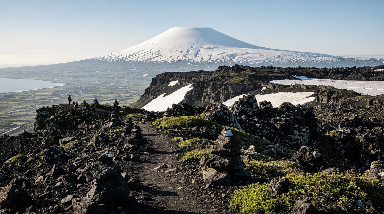
The pass itself sits on the ice-polished bedrock of the Eyjafjallajökull edifice — a composite volcano built over hundreds of thousands of years of repeated eruption. The ice that covers its summit (the Eyjafjallajökull icecap) fills the original summit caldera. Walking along the pass edge, you are standing on the outer rim of this system.
The descent into Þórsmörk enters a completely different geological setting — the protected valley carved by glacial erosion during the last ice age, now filled with sediment and supporting the birch woodland. The Markarfljót river has been cutting into the outwash plain since the glaciers retreated, creating the dramatic canyons visible from the Þórsmörk ridge viewpoints.
The 2010 eruption and what it produced
The Eyjafjallajökull eruption of April to June 2010 is famous globally for disrupting European air travel, but on the ground it was also a spectacular creative geological event. The eruption began on 20 March 2010 at Fimmvörðuháls itself — not at the summit caldera but at the pass, creating two fissure vents that produced lava flows and the two craters now named Magni and Móði.
The fissure eruption at the pass was relatively gentle — lava effusion rather than explosive eruption. Hikers and photographers watched from a short distance during the initial weeks. Then in April, the eruption migrated to the summit caldera under the ice, producing the explosive ash eruption that closed European airspace. The ice melting contact caused the dramatic ash clouds.
Walking through the Magni and Móði craters today, you see rocks that formed in 2010 — among the youngest surface rocks accessible on foot anywhere on earth. The orange oxidation colour on the inner crater walls is iron reacting with the atmosphere over 15 years of weathering.
Accommodation near the trailheads
Near Skógar: the Skógafoss Guesthouse and Skógar Folk Museum guesthouse are both within walking distance of the trailhead. A handful of additional guesthouses and farmhouses operate within 5 km. Book well in advance for July.
At Þórsmörk: the Langidalur FÍ hut (sleeping-bag accommodation, book at fi.is), Básar FÍ hut, and Húsadalur/Volcano Huts (more comfortable, own booking site at volcanohuts.com). All require advance booking.
Timing strategy: the best approach for a one-way crossing is to stay at Skógar the night before departure, hike to Þórsmörk by early afternoon, and either take the late afternoon bus back or stay overnight at Þórsmörk. This eliminates the anxiety of racing a bus schedule on the day.
What the locals know
Icelanders who live near the Skógar area tend to walk the lower waterfall canyon regularly but fewer do the full Fimmvörðuháls crossing — it is physically demanding and the logistics of the Þórsmörk return require planning. Most guided hiker groups from Reykjavík cross it as a day trip, departing early and returning late.
The most underrated thing about this hike is the waterfall count. Most people list the highlights as the craters and the pass views, but the lower canyon’s 25+ waterfalls, seen in sequence from a narrow trail that runs above, beside, and behind them, is one of the most varied waterfall experiences in Iceland. Skógarfoss at the base is the first; each subsequent one is smaller but often more intricate. The final falls near the snow line have the most dramatic framing — narrow channels of water cutting through rock layers with the ice-capped summit above.
Planning your Fimmvörðuháls trip: the checklist
Before departure, confirm:
- Weather forecast at vedur.is specifically for the Þórsmörk/Fimmvörðuháls area (not just south coast)
- Hiking plan registered at safetravel.is
- Bus times confirmed at re.is or trex.is (both the Skógar arrival bus and Þórsmörk departure)
- Overnight accommodation at both ends if doing the crossing over two days
- Microspikes packed (June and early July) — check recent trail reports on hiking forums
- Sufficient food and water for 8–10 hours (no resupply possible on the trail)
- Emergency contact knows your itinerary and expected return
The Skógar Folk Museum and starting the hike right
Most hikers arrive at Skógar focused on the trail and miss the Skógar Folk Museum, which sits at the trailhead. The museum contains the best collection of traditional Icelandic farmhouse artefacts outside Reykjavík and includes a turf farm reconstruction that illustrates how Icelanders lived before industrialisation.
The museum is worth 45–60 minutes and provides useful context for the landscape you are about to cross. The folk who farmed the south coast plains below Eyjafjallajökull were directly affected by the 1783 Laki eruption (which produced a volcanic fume cloud that killed 60% of Iceland’s cattle, 80% of its sheep, and roughly a fifth of its human population), the 1875 Askja tephra fall, and the 2010 Eyjafjallajökull eruption. The landscape you hike through has been reshaping human lives for centuries.
Entry to the museum: ISK 2,200 adults, children free. Open daily in summer.
What the pass looks like in different conditions
Early July with snow: the upper pass section from the craters to the highest point is compacted snow that requires microspikes or crampons. The views are extraordinary but navigation requires care — snow can obscure trail markers. The contrast between fresh snow and the vivid lava from 2010 is spectacular photographically.
Mid-July to mid-August, dry: the optimal window. Pass is snow-free in most years. Clear trail visible throughout. The lava fields around the craters have vegetation beginning to colonise the edges — liverwort and moss appear first, starting the centuries-long process of biological succession on new lava.
Late August: early autumn conditions can bring fresh snow to the pass. The valley below Þórsmörk shows the first autumn colour on the birch. Fewer hikers than July; a good choice for those who prefer space.
Rainy conditions: the trail surface becomes slippery on the upper volcanic scree and the lower birch roots. The waterfalls in the canyon become more powerful and dramatic. The views from the pass disappear into cloud. A day of rain is not unusual in August; carry full waterproofs and accept that the pass section may not have the views visible on social media.
Altitude sickness at Fimmvörðuháls?
At 1,067 m the pass is not high enough to cause altitude sickness for most people. However, the rapid ascent (900 m in 8 km) can cause significant breathlessness, dizziness from exertion, and dehydration-related headache — symptoms sometimes misread as altitude symptoms. The remedy is pace management (slower is faster when the alternative is stopping every 10 minutes) and consistent hydration throughout the climb.
People who have recently arrived from a very low-altitude environment (sea level, long-haul flight) occasionally feel the pace more acutely. Give yourself a day at Reykjavík elevation before attempting the pass.
After Fimmvörðuháls: what to do in Þórsmörk
Arriving in Þórsmörk after the Fimmvörðuháls crossing, most hikers have 2–3 hours before the evening bus. The most sensible use of that time:
Eat: the Húsadalur resort café or the simple kitchen at the Langidalur hut for self-catering. After 8–10 hours on the pass, a hot meal is not optional. Bring enough food from the start to cover this — do not rely on the hut kitchen being stocked.
Valahnúkur viewpoint (90 minutes return): if you have the legs for it, the ridge above Þórsmörk gives the full valley view including all three glaciers. The contrast between the volcanic pass you crossed and the sheltered birch valley below is dramatic from this vantage.
Rest: equally valid. The Fimmvörðuháls crossing earns a rest. Sit in the valley, look at the birch, feel the wind-free warmth, and appreciate the contrasting environments you have walked between in one day.
Frequently asked questions about Fimmvörðuháls hike
Is Fimmvörðuháls harder than the Laugavegur?
Fimmvörðuháls is harder per kilometre — the climb from Skógar is 900 m in 8 km, and the pass section crosses ice and loose volcanic rock. However, it is done in one day rather than four, and there are no overnight logistics to manage.Do I need crampons for Fimmvörðuháls?
In June and early July, yes — microspikes or light crampons are advisable on the icy sections near the pass. By late July and August the snow typically melts from the main path. Check conditions with local operators before departure.Can I walk Fimmvörðuháls as a day hike from Reykjavík?
It is very long from Reykjavík — you would need to bus to Skógar (2.5 hours), hike 8–10 hours, then bus back from Þórsmörk. That makes for a 16+ hour day. Staying the night at Skógafoss hostel or Þórsmörk huts simplifies the logistics considerably.Is there accommodation on the trail?
Two unstaffed emergency huts exist near the pass. The Baldvinsskáli hut (unmanned) and the Fimmvörðuskáli hut (staffed mid-July to mid-August, sleeping-bag accommodation) provide shelter. Book Fimmvörðuskáli through fi.is.What are the Eyjafjallajökull craters like?
The 2010 eruption created two new craters — Magni and Móði — named after the sons of Thor. They are now cool enough to approach safely, with vivid orange and red oxidised rock still visible. The contrast between new lava and old snow is visually striking.Can I hike Fimmvörðuháls in the opposite direction?
Yes, from Þórsmörk to Skógar. This direction starts with a gentler climb through birch woodland and gets the steep descent to Skógar over with at the end when legs are tired. Both directions are equally valid.
Top experiences
Bookable activities with verified prices and instant confirmation on GetYourGuide.

Top experiences
Best-rated activities across GetYourGuide and Viator.

Sólheimajökull Glacier Hike – Adventure in a Small Group
- Viator

Blue Ice Discovery – Guided Glacier Hike from Skaftafell
- Viator

Glacier Hike from Skaftafell - Extra Small Group
- Viator

Sólheimajökull Glacier Hike - Small Group Blue Ice Adventure
- Viator

Skaftafell Glacier Hike 3-Hour Small Group Tour
- Viator

Solheimajokull Glacier 3-Hour Small-Group Hike
- Viator