Laugavegur trek — the complete hiking guide
Reykjavik: Landmannalaugar day hike 4 hour
How long is the Laugavegur trek and how hard is it?
The Laugavegur trail runs 55 km from Landmannalaugar to Þórsmörk, taking most hikers 4 days. Difficulty is moderate — no technical climbing required, but river crossings and highland weather make it unsuitable for complete beginners.
The Laugavegur trek connects two of Iceland’s most extraordinary highland landscapes across 55 kilometres of geothermal terrain, obsidian fields, glacial rivers, and green valley floor. Walking from Landmannalaugar in the Fjallabak Nature Reserve to Þórsmörk takes most people four days and earns its reputation as one of the finest multi-day hikes in Europe — not because it is technically demanding, but because the scenery changes so completely every few hours that it barely feels like the same country.
What the trail looks like end to end
The standard direction runs southwest from Landmannalaugar to Þórsmörk. Elevation at the start sits around 600 m; the trail reaches its high point near 1,100 m on the Hrafntinnusker plateau before descending through the Emstrur valley and arriving at the birch-filled gorges of Þórsmörk.
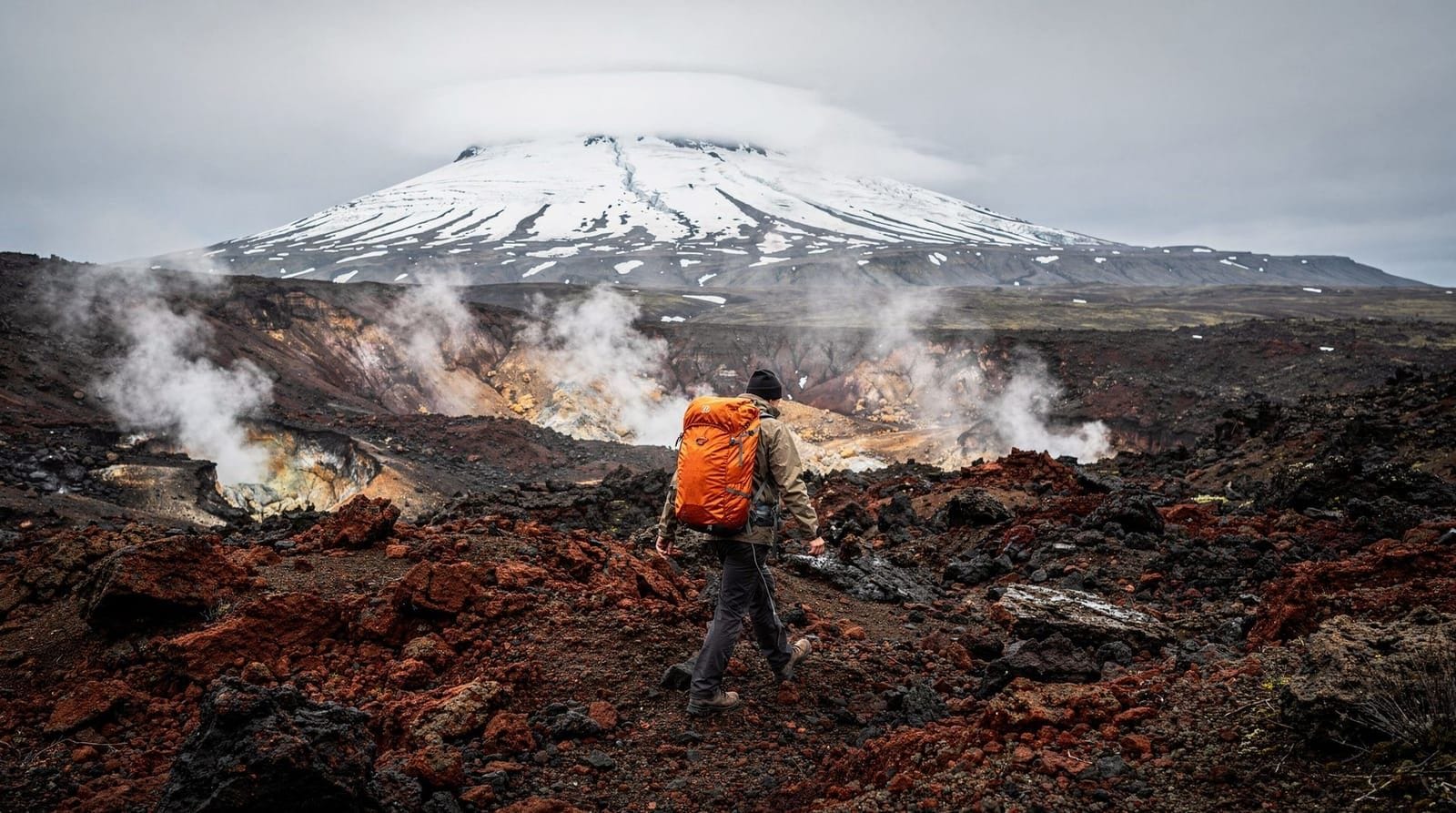
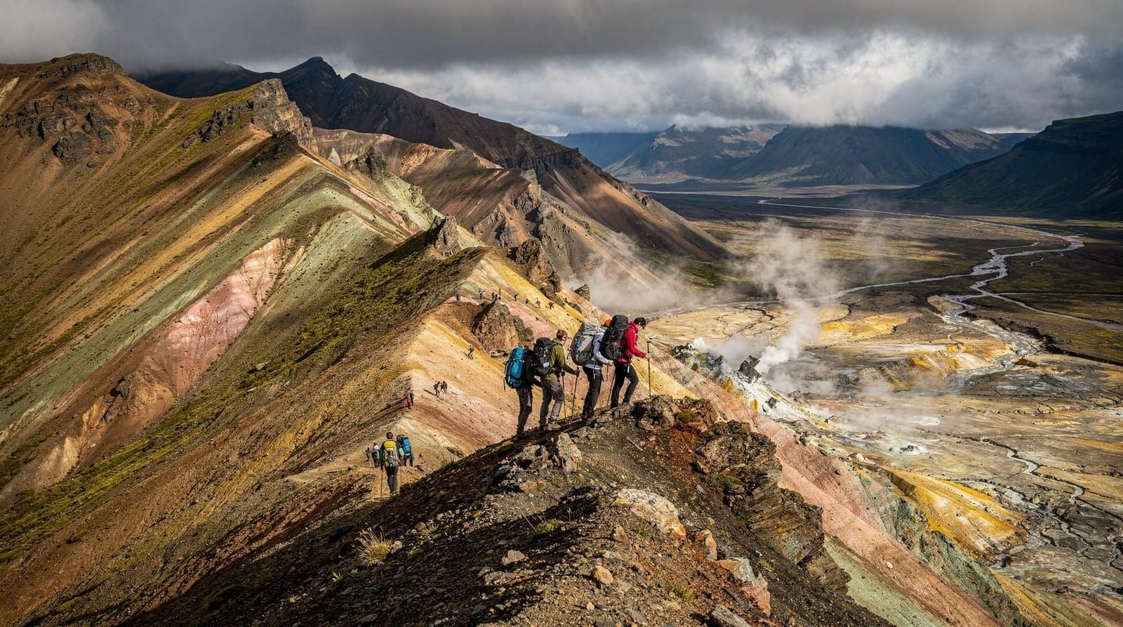
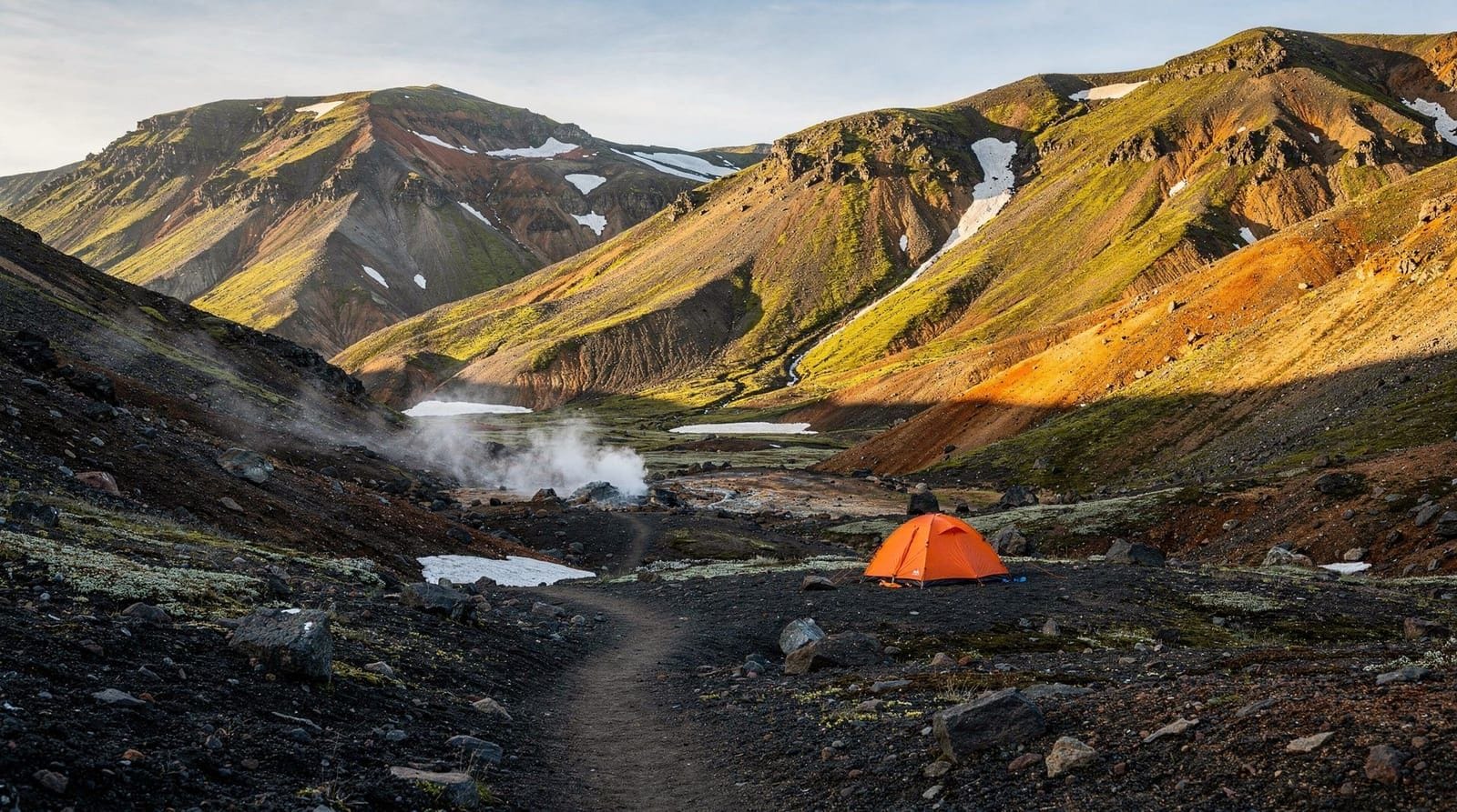
Day 1 — Landmannalaugar to Hrafntinnusker (12 km, 5–6 hours). The trail opens with a walk across multicoloured rhyolite hills in pinks, greens, and yellows before climbing past Brennisteinsalda volcano to the obsidian ridge at Hrafntinnusker. The landscape here is almost lunar. Hot springs near the hut allow you to warm up after a cold descent.
Day 2 — Hrafntinnusker to Álftavatn (12 km, 4–5 hours). The second day descends dramatically from the high plateau to the twin lakes Álftavatn and Froststaðavatn. Several river crossings appear en route — knee-deep, cold, and unavoidable. The hut at Álftavatn sits on a flat green shelf above the lake with a stunning view south towards the coast.
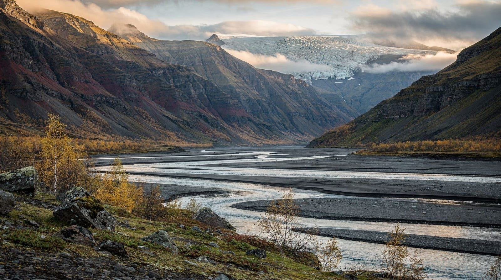
Day 3 — Álftavatn to Emstrur/Botnar (15 km, 5–6 hours). The longest section crosses the black sand plain of Jökulgil and passes the edge of Mýrdalsjökull glacier. The Bláfjallakvísl and Þröngá rivers require careful crossings — unbuckle your pack straps, use a hiking pole on the upstream side, and cross with a companion if possible.
Day 4 — Emstrur to Þórsmörk (15 km, 5–6 hours). The final day drops into the spectacular river canyon near Markarfljótsgljúfur before entering the birch woodland and sheltered valleys of Þórsmörk. The contrast between the bare highland and the leafy green valley feels like walking from the moon to the English countryside. Buses return from Þórsmörk to Reykjavík via Seljalandsfoss (3.5 hours).
Booking huts: the only part that requires planning months ahead
The Ferðafélag Íslands (FÍ / Icelandic Touring Association) manages all huts along the trail: Hrafntinnusker, Álftavatn, Emstrur/Botnar, and the Þórsmörk complex (Básar and Langidalur). Bookings open in January for the coming summer season. Popular dates in July fill within hours of opening.
For 2026, hut sleeping-bag accommodation costs ISK 14,000–17,000 per person per night (approximately EUR 90–110). Huts include cooking facilities, drying rooms, and basic toilets. Showers cost extra (ISK 600–800). Camping spots at each hut site cost ISK 3,500–5,000 per tent per night and typically remain available longer than hut beds, but carrying a cold-rated tent and sleeping bag adds 3–4 kg.
Book at fi.is. The Þórsmörk complex is operated separately; check thorsmork.is for the Þórsmörk end of the route.
River crossings: how to cross safely
Unbridged river crossings are the biggest practical challenge on the Laugavegur. Rules that experienced highland hikers follow:
- Cross in the early morning when overnight cold has reduced glacial meltwater flow.
- Undo hip belt and sternum strap before entering — a fall with a fastened pack is dangerous.
- Use a sturdy pole on the upstream side for a third contact point.
- Face slightly upstream and move diagonally downstream, never directly across.
- If the water reaches above mid-thigh on a 170 cm adult, the crossing is too high — wait 2–4 hours.
- Never cross directly after rain; check the river level report at vegagerdin.is (Icelandic Road Administration).
The most challenging crossings come on Day 3 between Álftavatn and Emstrur. Guided parties have guides who assess conditions first — this is the main practical benefit of joining an organised group.
If you want the Þórsmörk experience without committing to 4 days on the trail, a super-jeep day tour from Reykjavík reaches the valley in 3–4 hours with several short hike options included.
Gear and packing for the Laugavegur
The highlands do not forgive under-preparation. The following items are non-negotiable:
Clothing: waterproof jacket and trousers rated for sustained rain; merino or synthetic base layers (no cotton); insulating mid-layer; hat and gloves even in July; gaiters for river crossings.
Footwear: broken-in waterproof hiking boots with ankle support. Trail runners are popular among fast hikers but make river crossings wetter and colder.
Pack weight: aim for 12–15 kg total including food for 4 days. Every kilogram above this increases exhaustion significantly on the hut-to-hut distances.
Navigation: download the map on maps.me or Gaia GPS before entering the highlands where mobile coverage is unreliable. The WOW Air app is no longer operational — use the Safetravel app and register your hiking plan.
Emergency: carry a personal locator beacon (PLB) or satellite messenger (Garmin inReach) if hiking without a guide. Rescue operations in the highlands are expensive and slow; PLBs can be rented in Reykjavík.
The Fimmvörðuháls extension
Many hikers extend the trek by walking the Fimmvörðuháls route from Þórsmörk over the 1,067 m pass to Skógarfoss. This adds one very full day (24 km, 8–10 hours) and passes directly between the craters created by the 2010 Eyjafjallajökull eruption. The section is frequently clear of snow by mid-July and the views toward Mýrdalsjökull and out to the coast are extraordinary. You descend directly to Skógar, from where bus connections run back to Reykjavík.
The combined Laugavegur + Fimmvörðuháls route is 79 km over 5 days and is considered the definitive Iceland highland trek.
Without the full 4-day commitment
If four days in the highlands is not feasible, there are two realistic alternatives.
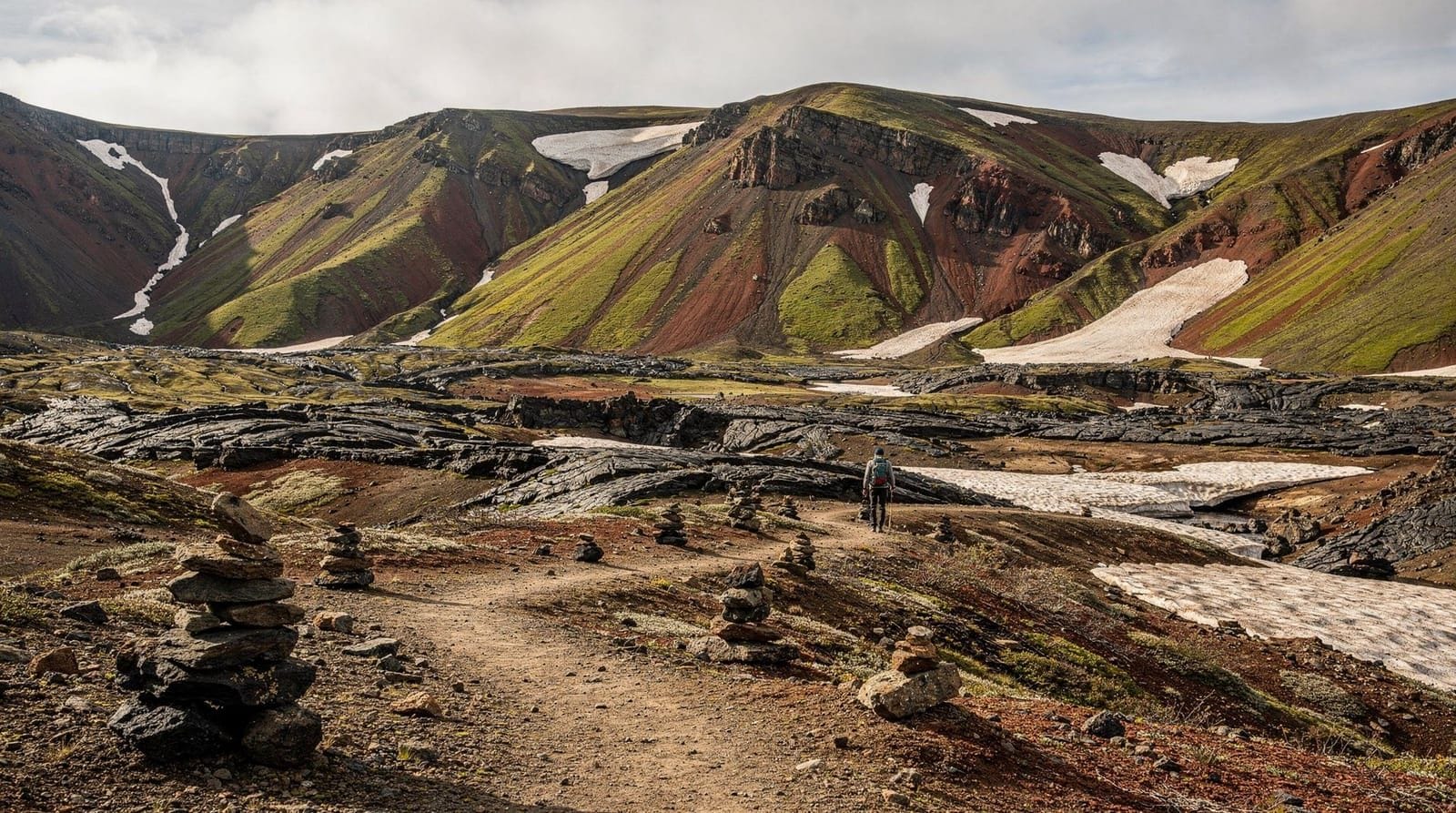
The first is a day hike from Landmannalaugar. The trailhead itself sits inside the Fjallabak Nature Reserve and several half-day loops from the parking area cross the rhyolite hills and skirt the geothermal hot springs at the Landmannalaugar campsite. No hut booking required — just transport to the trailhead.
A guided day hike from Reykjavík takes you directly to Landmannalaugar and includes a 4-hour hike through the multicoloured hills, returning to the city by evening.
The second option is joining a guided Þórsmörk day tour from the south coast, which puts you in the valley for 4–5 hours without the multi-day logistics. See the Þórsmörk hiking guide for more on this approach.
Transport to and from the trailheads
Landmannalaugar: Reykjavík Excursions (re.is) runs highland buses from Reykjavík BSÍ terminal from late June. Journey time is approximately 3.5 hours each way via Route F26. Buses also serve Landmannalaugar from Hella and Selfoss. The road (F26/F208) requires a 4WD vehicle if self-driving — standard hire cars are not permitted on F-roads. See F-roads Iceland for full details.
Þórsmörk: Buses run from Reykjavík via Seljalandsfoss; Trex and Reykjavík Excursions both serve this route. A super-jeep is needed for the final river crossing into the valley — scheduled bus services use purpose-built high-clearance coaches. Journey time from Reykjavík is 3–3.5 hours.
Book bus seats at re.is or trex.is. Do not assume tickets will be available on the day.
What the experience actually costs
A typical Laugavegur hiker spending 4 nights in huts pays approximately:
- Hut accommodation (4 nights): ISK 56,000–68,000 (EUR 360–440) per person
- Bus Reykjavík to Landmannalaugar (single): ISK 9,000–12,000 (EUR 58–78)
- Bus Þórsmörk to Reykjavík (single): ISK 8,000–10,000 (EUR 52–65)
- Food (self-catered, brought from Reykjavík): ISK 8,000–12,000 (EUR 52–78) for 4 days
Total before gear: ISK 81,000–102,000 (EUR 522–658) per person. Gear rental in Reykjavík (if needed) adds ISK 10,000–25,000. Guided options cost EUR 900–1,600 all-inclusive for a 4-day group tour.
Camping the whole route cuts accommodation cost by roughly 60%, but adds gear weight and cold exposure. Most first-timers find the huts worth the cost.
Frequently asked questions about the Laugavegur trek
Is the Laugavegur trail suitable for beginners?
The trail is moderate — no ropes, crampons, or technical experience required. But the sustained multi-day distances, river crossings, and unpredictable highland weather mean complete beginners should do at least two overnight hikes in variable conditions before attempting it. Fitness matters more than technical skill.
Can I walk just part of the Laugavegur?
Yes. The most popular standalone section is Landmannalaugar to Álftavatn (Days 1–2), which ends at a hut with bus access to Reykjavík via Hella. The Emstrur to Þórsmörk section (Day 4) is also walkable as a standalone if bussed into Þórsmörk in reverse.
Is there mobile coverage on the trail?
Sporadic. Siminn and Vodafone Iceland have coverage near the huts. Open ridgelines often have no signal. Download offline maps before departure.
What happens if weather forces the trail to close?
Trail closures are rare but hut wardens will advise on dangerous conditions. The Safetravel Emergency Line is 112. Wardens have authority to stop hikers from proceeding if crossings are at flood stage.
Is the Laugavegur crowded?
It has become significantly busier since 2015. July weekends at the main huts feel like busy campsites. The most reliable way to find solitude is to walk in early September when huts are still open but visitor numbers have dropped by 50-60%.
Do I need travel insurance for the Laugavegur?
Yes — and it must cover mountain rescue and helicopter evacuation. Icelandic rescue services are excellent but helicopters in the highlands cost EUR 5,000+ per call-out. Standard travel insurance may not cover this. Read your policy carefully and upgrade if necessary.
Where do I register my hiking plan?
At safetravel.is. Registration takes 5 minutes and allows search and rescue to locate you if you fail to check in at the end of your trip. This is not legally mandatory but strongly recommended — the Icelandic Association for Search and Rescue (ICE-SAR) provides this service free of charge.
The huts in detail
Each of the four main huts on the Laugavegur has a distinct character shaped by its location and the terrain around it.
Landmannalaugar (start, not an overnight hut). The trailhead base camp. The FÍ hut here is the largest, with the most facilities and the geothermal hot spring bathing pool nearby. Most hikers arrive the afternoon before Day 1, bathe, eat their own food in the communal kitchen, and sleep in dormitory bunks. The energy is anticipatory — people are checking gear, studying maps, comparing notes on conditions.
Hrafntinnusker (Day 1 end, 12 km). The most dramatic overnight location on the trail, at 1,100 m elevation on the obsidian plateau. The hut is small and the terrain around it is genuinely alien — dark obsidian ridges, hot steam vents, and often snow even in July. Temperatures drop significantly at night. The area is named for the Hrafntinnusker (“Raven Flint Cliff”), a ridge of obsidian that catches the evening light.
Álftavatn (Day 2 end, 24 km). Set above twin glacial lakes on a green shelf, Álftavatn (“Swan Lake”) is the warmest and most scenically orthodox of the huts — the view southward from the hut site toward the coast is clear on good days, and the highland character of the landscape is starting to soften. River crossings are required to reach this hut from the Hrafntinnusker side, which means Day 2 ends with wet boots regardless of how carefully you cross.
Emstrur/Botnar (Day 3 end, 39 km). Emstrur sits in a broad valley with the Mýrdalsjökull glacier visible to the east. The canyon at Markarfljótsgljúfur begins nearby — some hikers walk 20 minutes to the canyon viewpoint before dinner, which is worth the extra distance. Day 3 is the hardest physically, so the hut arrival is the most satisfying of the trail.
Þórsmörk/Langidalur or Básar (Day 4 end, 55 km). The trail’s end in the birch woodland of Þórsmörk feels entirely different from the highland environment of the previous four days. The FÍ huts at Langidalur and Básar are comfortable, well-run, and usually full with a mix of through-hikers and visitors who came in on the day bus. The feeling of having walked from Landmannalaugar to here is genuinely satisfying.
Training and preparation timeline
The Laugavegur is not a race but fitness preparation makes the difference between an enjoyable experience and a miserable one. A practical preparation timeline for someone starting from a general fitness baseline:
8 weeks before: start hiking 2–3 times per week on terrain with at least 300 m of elevation gain. Walk with a loaded pack (8–10 kg) on at least two of these.
4 weeks before: one overnight hiking trip with a full pack, in variable weather if possible. This identifies gear that doesn’t work, boots that need more breaking in, and fitness gaps.
2 weeks before: reduce hiking intensity; focus on rest and gear checking. Your conditioning is mostly set at this point.
Gear check: test the waterproofing on your jacket by standing in rain for 10 minutes. Wipe the external seams with a DWR (durable water repellent) spray if they are wetting out.
Photography on the Laugavegur
The Laugavegur offers four distinct photography environments in four days:
Day 1 is the best day for landscape photography of the rhyolite colour fields — the late afternoon light on the Brennisteinsalda and Suðurnámur ridges near Landmannalaugar is extraordinary. The obsidian ridge approach to Hrafntinnusker gives angular, dark-toned compositions that contrast completely with the colours of the start.
Day 2 includes the best water photography — the river crossings in morning light, the blue-grey Álftavatn lakes in the valley below, and the graduated landscape shift from volcanic plateau to green valley floor.
Day 3 provides glacier proximity — Mýrdalsjökull is close enough to photograph on clear days from the Emstrur approach. The canyon at Markarfljótsgljúfur offers narrow-gorge compositions.
Day 4 is the birch woodland finish — completely different from anything in the previous three days, and often bathed in good afternoon light as you arrive at Þórsmörk.
Camera practical notes: a mirrorless body in a waterproof bag (or lined with a dry bag) is more practical than a DSLR in the persistent rain common on Days 2–3. Bring more memory cards than you think you need. Phone cameras perform surprisingly well on the trail — the iPhone 15 Pro manages most conditions adequately.
The other highland treks: how Laugavegur compares
Iceland has other multi-day highland routes worth knowing about:
Kjölur route (100 km, 5–6 days): a longer but lower-altitude route across the central highland plateau from Gullfoss to the north. Less dramatic terrain than the Laugavegur but genuinely remote and rarely walked by international visitors.
Fimmvörðuháls extension (24 km, 1 day): the natural extension from Þórsmörk to Skógar over the volcano pass. Combined with Laugavegur, this creates the definitive 5-day highland traverse described in the Fimmvörðuháls guide.
Öxnadalsheiði route (2–3 days, north Iceland): a less-documented highland route in the north. Excellent for those wanting more obscure territory. Limited infrastructure.
For first-time highland hikers, the Laugavegur remains the correct choice — the infrastructure of FÍ huts, the density of extraordinary scenery, and the accessible endpoint at Þórsmörk make it the benchmark highland trek in Iceland.
Frequently asked questions about Laugavegur trek
When is the Laugavegur trek open?
Huts open mid-June; the season runs until mid-September. Early July brings the most reliable weather and snow-free river crossings. Shoulder dates (late June, early September) are possible but cold nights and unpredictable rivers add difficulty.Do I need to book huts in advance?
Yes, well in advance — often 6-9 months ahead for July dates. The Ferðafélag Íslands (Icelandic Touring Association) opens bookings each January. Camping spots at each hut can be added as a backup, but weather demands a tent rated for sub-zero temperatures.Can I walk Laugavegur unsupported, without a guide?
Yes. The trail is clearly marked with cairns. Hikers must register a hiking plan at safetravel.is before departure. A guide is not legally required but guided groups benefit from leader experience on river crossings.How much does hut accommodation cost?
Sleeping-bag accommodation in FÍ huts costs around ISK 14,000–17,000 (EUR 90–110) per person per night. Camping at hut sites costs around ISK 3,500–5,000 (EUR 22–32) per tent per night.What river crossings are involved?
Several knee-deep glacial rivers must be crossed without bridges, most notably between Emstrur and Þórsmörk. Water levels fluctuate with temperature — early morning crossings are safest when overnight cold has reduced meltwater.Is the Laugavegur trail suitable for children?
Generally not recommended for children under 12 due to river crossings, cold weather, and multi-day distances. Strong teenage hikers with prior multi-day experience can manage it.Can I walk the trail in the opposite direction?
Yes. Some hikers prefer Þórsmörk to Landmannalaugar for the dramatic opening views of the lava fields. The main practical difference is that bus access at Landmannalaugar is easier to coordinate as an endpoint.What transport serves the trailheads?
Reykjavík Excursions and Trex run highland buses from Reykjavik to both Landmannalaugar and Þórsmörk (via Seljalandsfoss) from late June. Bookings recommended — buses fill quickly.
Top experiences
Bookable activities with verified prices and instant confirmation on GetYourGuide.

Top experiences
Best-rated activities across GetYourGuide and Viator.

Sólheimajökull Glacier Hike – Adventure in a Small Group
- Viator

Blue Ice Discovery – Guided Glacier Hike from Skaftafell
- Viator

Glacier Hike from Skaftafell - Extra Small Group
- Viator

Sólheimajökull Glacier Hike - Small Group Blue Ice Adventure
- Viator

Skaftafell Glacier Hike 3-Hour Small Group Tour
- Viator

Solheimajokull Glacier 3-Hour Small-Group Hike
- Viator