Dettifoss guide — visiting Europe's most powerful waterfall
Akureyri: From Akureyri Diamond Circle tour with waterfalls
How do I get to Dettifoss and which road is better?
Two roads reach Dettifoss from opposite sides of the canyon. Road 862 (east bank, paved) is most visited and better for standard cars. Road 864 (west bank, gravel) gives a different angle with fewer people but requires a more capable vehicle. From Akureyri it's 160 km, about 2 hours each way.
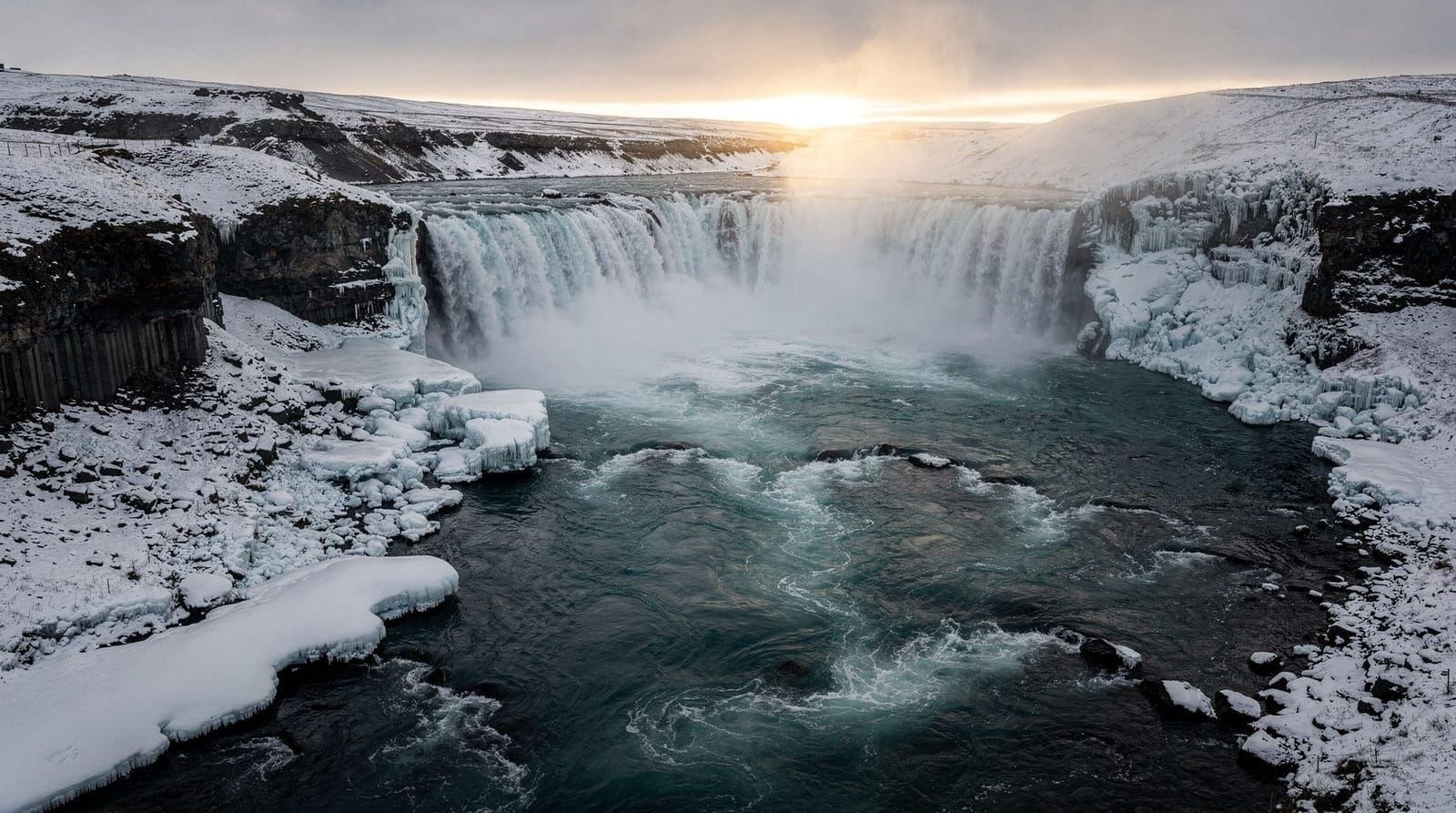
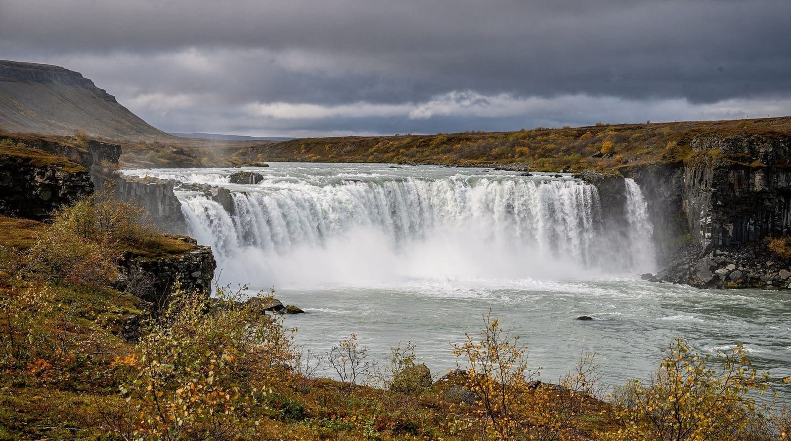
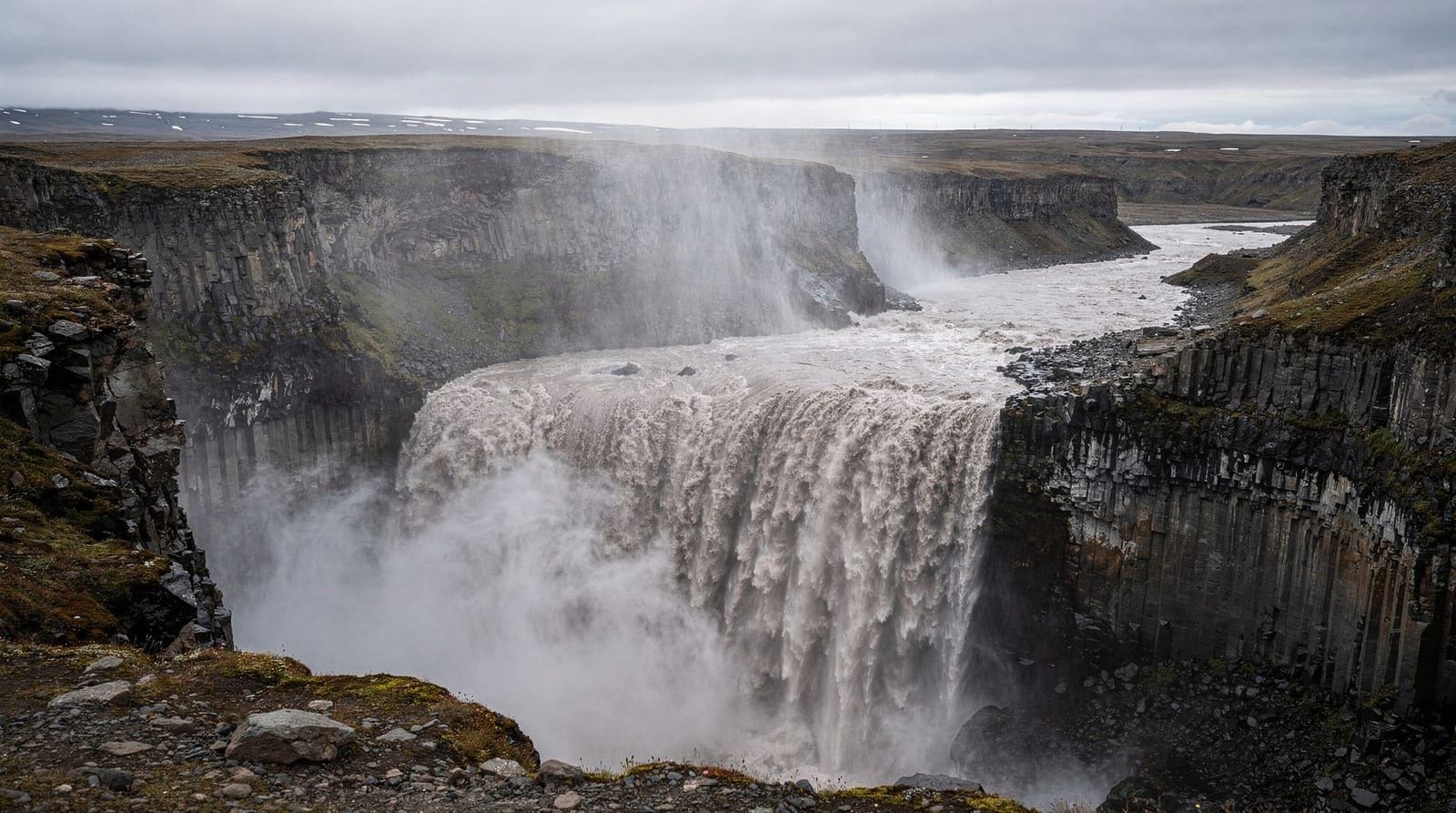
Dettifoss sits in Vatnajökull National Park in northeast Iceland, and by any measure it is the most overwhelming waterfall in the country. It is 44 m high and 100 m wide, but the statistic that matters most is flow: in summer, the Jökulsá á Fjöllum river pushes 500 m³/s over the edge — the highest average flow of any waterfall in Europe. The water is grey-brown with glacial sediment, the roar is heard a kilometre away, and the mist column is visible from further still.
It was filmed as the alien-world landscape in the opening sequence of Ridley Scott’s Prometheus (2012). Seeing it in person, the choice makes sense.
Why Dettifoss feels different
Most Icelandic waterfalls are white. Dettifoss is not. The Jökulsá á Fjöllum carries heavy glacial flour — fine rock particles ground by the Vatnajökull glacier — which gives the water a grey-brown colour that looks almost turbid compared to the blue-white falls of the south coast. This colour, combined with the black basalt canyon, creates a visual palette unlike any other Icelandic natural site.
The canyon itself (Jökulsárgljúfur) extends 25 km north from Dettifoss, and the section visible from the falls viewpoints shows just the first part of a geological feature that took approximately 10,000 years of catastrophic glacial floods to carve. Ásbyrgi canyon to the north was shaped by the same floods.
Road access: 862 or 864?
This is the main practical question for Dettifoss. The falls sit between two roads, each serving a different viewing bank.
Road 862 (east bank): Fully paved since 2019. Reaches the most popular viewpoint — a wide platform above the eastern canyon wall. Best for standard 2WD vehicles. Walk from the car park to the main viewpoint: about 400 m on a flat, maintained path.
Road 864 (west bank): Gravel throughout. Reaches the west bank viewpoint, which offers a slightly different angle and consistently fewer visitors. Also accesses Selfoss, a wider but shallower falls 1 km upstream that most east-bank visitors miss. Road 864 is generally passable in summer with a confident 2WD driver, but the gravel surface can be rough after rain. A high-clearance 4WD is more comfortable.
Winter access: Both roads may be snow-covered or iced from October to May. Road 864 is occasionally closed. Check road.is before travel in any season outside June–September.
The canyon walk to Selfoss
From either viewpoint, it’s possible to walk downstream (south) from Dettifoss to reach Selfoss, about 1 km upstream of Dettifoss. Wait — that means Selfoss is upstream, not downstream. Selfoss is 1 km south (upstream) of Dettifoss on the same river. Confusion about direction is common because of the name. Walk south on the riverbank trail about 1 km.
Selfoss is 10 m high and nearly 200 m wide — a completely different character from Dettifoss. Where Dettifoss is violent and concentrated, Selfoss is broad and more photogenic in a traditional sense. It almost never appears in travel photography despite being a significant falls in its own right.
The path is marked but uneven — worn volcanic rock and loose gravel. Standard hiking boots are fine. Time: 20 minutes each way.
Hafragilsfoss — downstream addition
North of Dettifoss, about 2 km downstream, Hafragilsfoss drops 27 m across a 91 m wide canyon. Accessing it requires either walking 2 km north along the canyon rim (no formal trail, pick your way across moorland) or driving north on Road 864 to a separate parking area.
Hafragilsfoss is less dramatic than Dettifoss but the canyon around it is arguably more photogenic — the walls here are black basalt columns that frame the falls precisely. Almost nobody stops here; it’s usually completely uncrowded.
Combining with the Diamond Circle
Dettifoss is one of four main stops on the Diamond Circle, the northern equivalent of the Golden Circle. The full Diamond Circle covers:
- Goðafoss — 50 km west of Akureyri
- Lake Mývatn — volcanic area, pseudo-craters, geothermal pools
- Dettifoss — Europe’s most powerful waterfall
- Ásbyrgi — horseshoe canyon, Norse mythology
The complete circuit is 400+ km from Akureyri and is best done as a 2-day trip or a very long single day. The north Iceland 4-days itinerary covers it properly.
A guided Diamond Circle day tour from Akureyri covers all four main stops including Dettifoss and Goðafoss. The guide context at Dettifoss specifically is valuable — the geology of the Jökulsá canyon is complex enough that a good explanation adds significantly to the experience.
Getting there independently
From Akureyri: Take Route 1 east toward Mývatn (about 100 km, 1.5 hours). Then Route 87 or Route 85 northeast toward Dettifoss. Via Road 862 (east bank), total distance from Akureyri is approximately 160 km, about 2 hours in normal conditions.
From Reykjavík: Dettifoss is approximately 530 km from Reykjavík via the Ring Road — a 5.5-hour drive one-way. This is a two-day trip from the capital minimum unless you drive very long days. Consider flying from Reykjavík (Akureyri domestic flights, around 60–80 minutes, 15,000–25,000 ISK / €100–170) and renting a car from Akureyri. See the domestic flights in Iceland guide.
What to wear and carry
Unlike the south coast waterfalls, Dettifoss sits in a more exposed highland setting. Weather can change rapidly, and the temperature at the falls is typically 3–5°C cooler than coastal areas.
Essentials:
- Wind and waterproof outer layer
- Sturdy hiking boots (the canyon rim walking is uneven)
- Water — no facilities at the falls themselves
- Snacks — the nearest café is in the town of Ásbyrgi (40 km north) or at Mývatn (80 km west)
The nearest toilets are usually at a small facility in the parking area (may be seasonal/not always open). Come prepared.
Photography at Dettifoss
The standard shot from the east bank viewpoint (Road 862) is dramatic but straightforward — a wide angle looking across the canyon to the falls. The challenge is the grey-brown water against the grey basalt, which can produce dull photographs without good light.
Best conditions: Overcast bright light (thin cloud) diffuses the image evenly. Direct sun creates harsh shadows in the canyon. The falls face roughly west, so the late afternoon sun in summer can provide warm side-lighting from the west bank.
For the west bank viewpoint (Road 864): the falls are viewed from a slightly different angle, showing more of the canyon mouth. The west bank has fewer people and is worth the rougher road.
Selfoss, 1 km upstream, is actually more photogenic in standard terms — the wide fan of water against the dark basalt canyon shoots better with a 70–150 mm lens.
Guided Diamond Circle tours from Akureyri often include both Dettifoss and Goðafoss in the same day, plus stops at Mývatn area sites. Self-driving is excellent if you have a capable vehicle; guided is better if you want maximum context and don’t want to navigate the gravel roads independently.
Safety at Dettifoss
This matters more here than at any other Icelandic waterfall. The canyon walls are unstable — sections of basalt have collapsed into the gorge multiple times in recent years, with no warning. The official viewpoints are positioned beyond the collapse risk zone; the “off-trail” area near the canyon edge is not.
Stay behind the marked viewpoint barriers. The spray at close range is blinding and the edge is closer than it looks. People have died at Dettifoss from going beyond barriers.
Frequently asked questions about Dettifoss
Is Dettifoss the largest waterfall in Iceland?
By volume (flow rate), yes — 500 m³/s in summer makes it the highest-flow waterfall in Europe. By height, no — Glymur (198 m) and Háifoss (122 m) both exceed Dettifoss’s 44 m drop. By width at the base, it is one of the widest at 100 m but Goðafoss is comparable.
Can I reach Dettifoss without a 4WD?
Yes, via Road 862 (paved), a standard 2WD is fine in summer. Via Road 864 (gravel), a standard 2WD works in dry summer conditions but a 4WD is more comfortable. In any shoulder season or winter conditions, 4WD is advisable for Road 864. See the 2WD vs 4WD guide.
Is there parking at Dettifoss?
Yes, a car park at each road’s termination point. Both are free. The east bank car park (Road 862) is larger. Facilities include basic toilets (seasonal).
How long should I spend at Dettifoss?
For the main viewpoint only: 30 minutes. Including the walk to Selfoss (2 km return): 1.5 hours. Including Selfoss, Hafragilsfoss, and canyon rim walking: 3+ hours.
Is Dettifoss from Prometheus real?
Yes. The opening sequence of Ridley Scott’s Prometheus was filmed at Dettifoss (and nearby areas of the Vatnajökull highland). The alien planet landscape is Iceland’s northeast interior. The waterfall is identifiable from the shape of the basalt canyon walls.
What’s the difference between Dettifoss and Goðafoss?
Both are in north Iceland. Dettifoss is much more powerful (500 m³/s vs Goðafoss’s approximately 50 m³/s) and the setting is more remote. Goðafoss is directly on Route 1 and requires no effort to access. Goðafoss is prettier in a conventional sense; Dettifoss is more overwhelming. Most north Iceland itineraries include both.
The geology behind Dettifoss’s power
The Jökulsá á Fjöllum is Iceland’s second-longest river at 206 km, draining a catchment area that includes some of the most active volcanic terrain on the island. It originates from springs fed by the Vatnajökull glacier meltwater, supplemented by geothermal water from the Kverkfjöll volcanic area and seasonal snowmelt from the northeast highlands.
What makes Dettifoss different from other Icelandic waterfalls is the catchment efficiency — the northeast highlands funnel enormous volumes of water into a single river that has no outlet other than this 100 m wide drop. In years of high precipitation combined with warm early summer (maximum melt), flow can briefly exceed 500 m³/s. In dry winters, minimum flow is around 40 m³/s — still high by European standards.
The canyon walls at Dettifoss are exposed basalt columns from ancient lava flows — horizontal flow units that stacked over millions of years of eruption cycles. The dark grey rock is 3–5 million years old; the canyon was carved through it relatively recently (geologically speaking) by post-glacial flooding.
The Jökulhlaup floods that built this landscape
The most dramatic geological events in north Iceland were the jökulhlaup — catastrophic glacial outburst floods — that occurred repeatedly as the last ice age ended and earlier glaciers retreated. A single event 8,000–10,000 years ago discharged an estimated 200,000–300,000 m³/s through this valley — over 400 times Dettifoss’s current peak flow.
These floods carved the entire Jökulsárgljúfur canyon system, created Ásbyrgi horseshoe canyon 25 km north, and deposited the sediment plains of northeast Iceland. The landscape you see at Dettifoss is the legacy of these catastrophic events, not of the current river’s gentle (by comparison) everyday flow.
Services and facilities near Dettifoss
There are essentially no services at Dettifoss itself. Plan accordingly.
The nearest fuel and food:
- Ásbyrgi: 40 km north on Route 85, has a campsite and basic café (seasonal)
- Húsavík: 65 km northwest, full town with petrol, supermarkets, restaurants
- Mývatn area (Reykjahlíð village): 80 km west, petrol station, supermarket, several restaurants
If you’re doing a full Diamond Circle day from Akureyri, fill up fuel in Akureyri before departing — you may not find convenient fuel between Akureyri and Dettifoss depending on your route.
Dettifoss in winter: a different beast
Winter access to Dettifoss is possible but requires planning. Road 862 (east bank, paved) is generally maintained through winter but may have compact snow or ice. Road 864 (west bank, gravel) is frequently closed or impassable from November to April.
In winter, the landscape around Dettifoss transforms — snow on the plateau, ice formations on the canyon walls, and the strange grey-brown water against white surroundings. The north Iceland light in January (sunrise around 11 am, sunset around 3:30 pm) gives a 4-hour window of usable light, all of it at low angle.
The west bank is effectively inaccessible in winter for most vehicles, which means you see only the east bank view. This is still excellent — but if the west bank perspective (with access to Selfoss) matters to you, plan for a summer visit.
Combining Dettifoss with Ásbyrgi
The 25 km stretch of canyon from Dettifoss north to Ásbyrgi forms the heart of the Jökulsárgljúfur section of Vatnajökull National Park. The multi-day canyon trail covering this distance (approximately 35 km with diversions) is one of Iceland’s better hiking routes, far less known than the south coast trails.
Day hikers can drive to Ásbyrgi and walk south along the canyon for 4–6 hours before returning. The canyon changes character every few kilometres — from open plateau above Dettifoss to narrow gorge sections, then widening to the broad vegetated canyon floor at Ásbyrgi.
If you’re combining Dettifoss with Ásbyrgi in a single driving day, allow 6–7 hours total for the drive, viewpoints at both, and the short hikes. See the north Iceland 4-days itinerary for a structured approach.
Dettifoss trip cost breakdown
Visiting Dettifoss is free (no entrance fee) but getting there involves costs:
Self-driving from Akureyri:
- Fuel for 320 km return: approximately 5,000–6,000 ISK (~€33–40) in a standard car
- Parking: free
- Food/drinks: bring your own; no services at the falls
- Total: under 7,000 ISK per car (not per person)
Guided Diamond Circle tour from Akureyri:
- Group tour: approximately 22,000–32,000 ISK (~€145–210) per person
- Includes transport, guide, all entry fees (where applicable)
- Duration: 10–12 hours
- Useful if you don’t have a car or want guided commentary
Domestic flight to Akureyri + car rental:
- Flight from Reykjavík to Akureyri: 15,000–25,000 ISK (~€100–165) each way
- Car rental from Akureyri: approximately 12,000–18,000 ISK (~€78–118) per day for a standard 2WD
- This approach makes sense if you have 3+ days in north Iceland and want to base yourself in Akureyri
See the Iceland on a budget guide for comprehensive cost comparisons and the renting a car in Iceland guide for vehicle hire advice.
Dettifoss vs Skógafoss vs Gullfoss: an honest comparison
All three are major Icelandic waterfalls but they offer fundamentally different experiences:
Gullfoss (south Iceland, 125 km from Reykjavík): Two-step cascade into a canyon. Golden light effects in afternoon. Accessible year-round with a 2WD. Part of the convenient Golden Circle. Moderate crowds.
Skógafoss (south Iceland, 150 km from Reykjavík): 60 m single curtain. Famous for double rainbows. Staircase and hiking trail above. Very crowded in peak season. Part of the south coast route.
Dettifoss (north Iceland, 530 km from Reykjavík): The most powerful. Grey turbid water in a dark basalt canyon. More remote and requires planning. Much fewer visitors than south coast falls. The most overwhelming physical experience of the three.
The comparison is somewhat unfair — they serve different purposes within an Iceland trip. Most visitors who do both south and north Iceland come away rating Dettifoss the most memorable purely because of the physical scale, but recommend Gullfoss and Skógafoss for their accessibility and aesthetic quality.
See the Iceland waterfalls guide for the complete ranking and the ring-road-guide for planning a trip that includes all three.
Top experiences
Bookable activities with verified prices and instant confirmation on GetYourGuide.
Top experiences
Best-rated activities across GetYourGuide and Viator.

Ice Cave by Katla Volcano Super Jeep Tour from Vik
- Viator

Puffin and Volcano Tour with Ebbi
- Viator

Dynjandi Waterfall & Farm Visit Tour from Isafjordur Port
- Viator

3,5-Hour Sightseeing Tour To Dynjandi Waterfall
- Viator

Volcano ATV Tour
- Viator

Lake Myvatn Day Tour and Godafoss Waterfall for Cruise Ships from Akureyri Port
- Viator