Iceland highlands 4-day itinerary — Landmannalaugar and Þórsmörk (summer)
Landmannalaugar: Hike valley of tears
The Icelandic highlands are accessible by road for roughly 3–4 months of the year. The rest of the time, they are buried under snow or cut off by glacial river floods. This seasonal limitation is not a problem — it is the defining characteristic of the interior, and it is why the landscape looks the way it does.
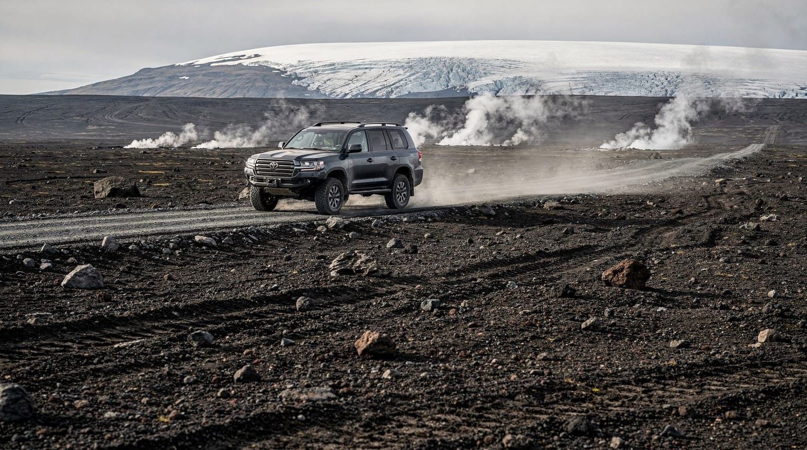
This 4-day itinerary covers the southern highland corridor: Landmannalaugar, the Laugavegur trail section between the highland hut system, and Þórsmörk at the southern end. The driving is on F-roads — the interior mountain tracks designated with an “F” prefix on Icelandic maps — which require a four-wheel-drive vehicle with river-crossing capability. No exceptions.
Critical access window: F-roads typically open in late June or early July and close again in late September or October. The exact dates vary by year and snowfall. Check vegagerdin.is or the Highlands Iceland website (fi.is) for current F-road status before planning. Driving an F-road while it is officially closed voids your rental insurance completely.
Vehicle requirements — non-negotiable
You need:
- A 4WD vehicle with high clearance (not an urban crossover — a proper high-clearance SUV: Dacia Duster 4WD minimum, Toyota Land Cruiser preferred)
- River-crossing clearance of at least 50 cm (most highland rivers in summer run 30–50 cm deep but conditions change)
- Gravel insurance covering F-road use (confirm explicitly with your rental company before signing)
- Full fuel tanks before departing paved roads
Route F26 (Sprengisandur) and Route F208 to Landmannalaugar both require multiple river crossings. There are no bridges. If you are not confident reading river conditions, hire a super-jeep tour instead.
Super-jeep day tours to Þórsmörk from Hvolsvöllur cover the highland roads in properly equipped vehicles with experienced drivers — a valid option if you have a standard rental car but still want to experience the interior valleys.
Day 1 — Reykjavík to Landmannalaugar via F208
The approach route
From Reykjavík, take Route 1 east to the Hella/Hvolsvöllur junction, then Route 26 north to the F208 turnoff — about 180 km to the start of the F-road, 2 hours on pavement. The F208 adds another 50 km and 1.5–2 hours depending on conditions, including several shallow river crossings (typically 20–40 cm in July). Total from Reykjavík to Landmannalaugar: approximately 3.5–4 hours with no stops.
Fill up at the N1 station in Hella before turning north — it is the last reliable petrol before Landmannalaugar. The Landmannalaugar hut complex sells emergency supplies (overpriced noodles, chocolate, basic food) but there is no petrol.
Arriving at Landmannalaugar
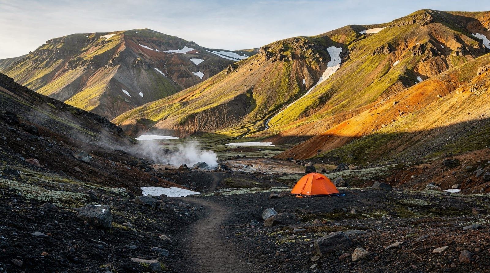
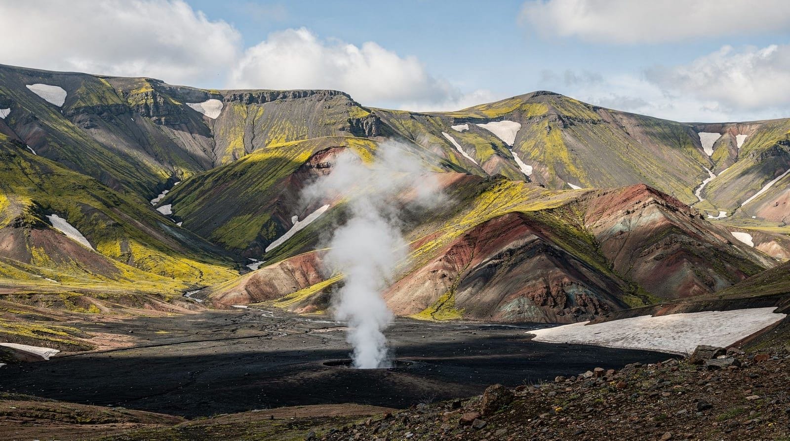
Landmannalaugar sits in the Fjallabak Nature Reserve at 610 metres altitude, surrounded by rhyolite mountains — the result of volcanic activity that pushed mineral-rich lava through older rock, creating the candy-coloured ridgelines of orange, pink, green, and purple that define this area’s visual identity.
The Ferðafélag Íslands (FI) hut complex has sleeping-bag accommodation at 9,500 ISK (€65) per person per night — book months in advance. There is also a campsite at 2,500 ISK (€17) per person. Both are operated by Ferðafélag Íslands; book at fi.is. Wild camping outside the designated area is not permitted in this zone.
The natural hot spring at the hut complex (free for hut and campsite guests) is a geothermal pool reaching 37–40°C — genuinely excellent after the drive. The cold river flowing into it creates a temperature gradient that you can regulate by moving in the pool.
Afternoon hike: Laugahraun lava field
The 3.5 km loop around the Laugahraun lava field is the ideal introduction to the Landmannalaugar landscape. The 1477 Veiðivötn eruption created this chaotic black lava flow surrounded by vibrantly coloured obsidian outcrops. Allow 1.5 hours. The trail is well-marked and easy underfoot.
Day tours from Reykjavík to Landmannalaugar include guided hikes in the rhyolite mountains — useful if you want local interpretation of the geology and colours, or if you have a standard 2WD rental that cannot reach the area independently.
Day 2 — Landmannalaugar hiking and exploration
Dedicate Day 2 entirely to hiking from the Landmannalaugar base. The two main routes:
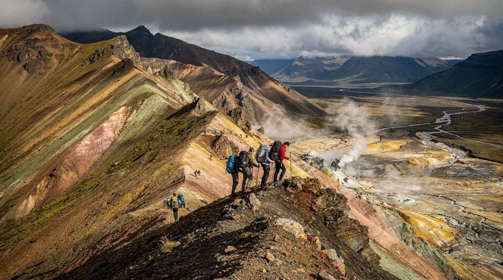
Option A: Brennisteinsalda (Mount Sulphur Crater, 4 km loop, 2–3 hours, moderate)
Brennisteinsalda is the most colourful peak in the Landmannalaugar area — the sulphur deposits create yellow-green crusted flanks, and fumaroles vent steam at the summit ridge. The summit at 855 metres gives views across the rhyolite landscape in all directions. The trail is clear but steep in the final 200 metres. Bring waterproofs — the summit is often in cloud even when the valley is clear.
Option B: The Landmannalaugar to Hrafntinnusker segment of Laugavegur (12 km one way)
This is the first day of the Laugavegur trek done as a day walk — the highest and most exposed section of the route, crossing obsidian fields, snowfields (often present into August), and the geothermal ridgeline above Stórihver hot spring. If doing the full 55-km Laugavegur end-to-end, this is your starting section. As a day walk from Landmannalaugar, plan 4–5 hours to Hrafntinnusker hut and back. It is exposed and cold above 900 metres even in July — full waterproofs, warm layers, and hiking poles are not optional.
Evening: return to the Landmannalaugar hot spring. Dinner at the hut is self-catering — bring your own food from Reykjavík or Hella. Gas canisters are sold at the hut.
Day 3 — Drive to Þórsmörk via F261 and F249
The drive south
The Þórsmörk valley can be reached from Landmannalaugar by the Laugavegur trail on foot (4 days of hiking) or by driving a complex F-road route south via F261 to Emstrur and then F249 to the valley. The F261 requires several river crossings, including the Markarfljót glacial river near Þórsmörk — consistently the deepest and most challenging crossing in the southern highlands, typically 50–80 cm in midsummer.
Honest assessment: if you are not experienced with glacial river crossings, do not attempt F249 in a standard rental 4WD. The Markarfljót can surge with glacial meltwater during warm afternoons. Several rental cars are recovered from this river each summer. The super-jeep services run by companies including Midgard Adventure and Þórsmörk Adventures are staffed by people who have crossed this river thousands of times.
Alternative: drive back to the Ring Road via the F208 and then approach Þórsmörk via Route 249 from the south side (Hvolsvöllur), which avoids the highland F-roads entirely. Route 249 is still rough gravel but the river crossing (Krossá) is typically shallower and more predictable.
Arriving at Þórsmörk
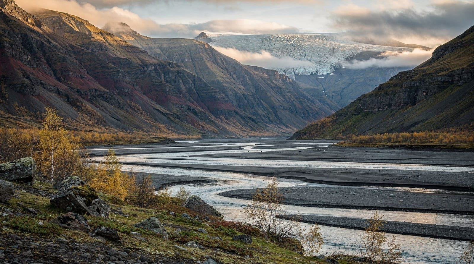
Þórsmörk (Thor’s Forest) is a glacially carved valley between the Mýrdalsjökull and Eyjafjallajökull glaciers. The valley floor is covered in birch forest — the densest natural forest in Iceland, which is still only chest-height. The combination of glacier walls, river braids, and woodland makes it visually unlike anywhere else in Iceland.
Accommodation: Þórsmörk has three hut complexes within 3 km of each other — Volcano Huts (glamping tents and huts, from 28,000 ISK / €190 per person with breakfast), Básar (FI basic hut, sleeping bags, 9,500 ISK / €65), and Langidalur (FI hut, similar price). Book all three well in advance.
Day 4 — Þórsmörk hiking and return to Reykjavík
Morning: Valahnúkur viewpoint
The Valahnúkur hike (3.5 km, 2 hours, moderate) climbs to a rocky viewpoint above Þórsmörk valley, giving a 360-degree panorama of the surrounding glaciers, rivers, and the distant silhouette of Eyjafjallajökull. This is one of the finest hike payoffs in Iceland relative to effort invested. Start early (07:00–08:00) to avoid afternoon heat and crowds.
Afternoon: Return to Reykjavík
If you drove in via F249 from the south, the return to Reykjavík is 150 km (2 hours via Hvolsvöllur and the Ring Road). If approaching from the north via the highland F-road route, reverse your approach.
The combined Þórsmörk super-jeep and hiking combo tours include the river crossings and the Valahnúkur summit hike — a complete experience without the river risk of a rental vehicle.
Note: the Þórsmörk area is also accessible via the Fimmvörðuháls hike from Skógar — a 25 km traverse across the volcanic plateau between Eyjafjallajökull and Mýrdalsjökull that ends in Þórsmörk. That hike takes 10–14 hours and is for experienced hikers only.
Practical notes on costs
Landmannalaugar and Þórsmörk hut accommodation: 9,500 ISK (€65) per person per night for sleeping-bag accommodation. Campsite fees: 2,500 ISK (€17) per person. Bring all food from Reykjavík — the hut shops are emergency supplies only at steep prices.
4WD rental with F-road insurance: budget 60,000–90,000 ISK (€410–€615) per day for a properly equipped Highland vehicle. Standard 4WD rental without F-road coverage is cheaper but leaves you liable for river damage — most policies list river damage as an uncovered event even in comprehensive packages. Read F-roads in Iceland and car rental insurance carefully.
Total cost per person for 4 days (sharing room/tent, cooking own food, with 4WD rental split between two): approximately 120,000–180,000 ISK (€820–€1,225).
The Laugavegur trail — doing it as a through-hike versus this driving itinerary
The Laugavegur trail is a 55-km hiking route from Landmannalaugar to Þórsmörk, widely considered one of the top 10 hiking trails in the world. Most through-hikers complete it in 4 days, staying at FI huts along the route. The hut system (Landmannalaugar, Hrafntinnusker, Álftavatn, Emstrur, Þórsmörk) requires advance booking — often 6–12 months ahead for peak July and August slots.
This 4-day driving itinerary is not the Laugavegur trail. It uses the same highland access roads and stays at the same endpoint huts, but covers the ground by vehicle rather than on foot. If you want to hike the trail:
- Book hut accommodation through fi.is, typically in February–March for July slots
- Allow 4–5 days for the trail itself plus transportation days at each end
- Gear requirements are significant: waterproofs, 25+ litre pack, hiking poles, crampons or microspikes for the Hrafntinnusker snowfields
- The trail is moderate-difficult: total distance 55 km, total ascent approximately 1,100 metres over 4 days
If you want to experience the highlands without hiking the full trail, this driving itinerary gives you access to both endpoints and allows day hikes from each base.
Budget and food in the highlands
The highland huts operate on a self-catering basis — all food must be brought from Reykjavík or the last town before the F-road. The hut shops at Landmannalaugar and Þórsmörk stock emergency supplies (ramen noodles, chocolate, basic snacks) at steep prices. They are not a meal plan.
Food planning per person for 4 days (self-catering):
- Breakfast: oats, dried fruit, nuts — 500–800 ISK (€3.40–€5.50) per person per day
- Lunch: bread, hard cheese, salami, trail mix — 800–1,200 ISK (€5.50–€8) per person per day
- Dinner: freeze-dried hiking meals or pasta with sauce — 1,200–2,500 ISK (€8–€17) per person per day
- Gas canister for 2 people for 4 days: 2,500 ISK (€17), available at Reykjavík outdoor shops (Útilíf, Ferðafélag Íslands shop) and at the Landmannalaugar hut
Bring more food than you think you need — the altitude and cold increase appetite, and there is no resupply option.
Frequently asked questions about this 4-day Iceland itinerary
When do the F-roads to Landmannalaugar open?
Typically late June to early July, but this varies by year. In 2023 the F208 opened on June 28; in 2022 it did not fully open until July 8. Always check vegagerdin.is or fi.is for the current official status. The road can also close temporarily after heavy rain even in August.
Can I do Landmannalaugar in a regular rental car?
No. Route F208 requires multiple river crossings that are impassable in 2WD vehicles, and many standard 4WD rental cars explicitly exclude F-roads in their insurance terms. If your rental does not specifically permit F-road use, you are driving illegally and will be billed for any damage. Use a designated Highland vehicle or take a day tour.
Is it possible to hike the full Laugavegur trail in this timeframe?
The Laugavegur trail (55 km from Landmannalaugar to Þórsmörk) takes 4–5 days for most hikers at a comfortable pace. Our 4-day driving itinerary is not designed for through-hikers — it covers the key sites by vehicle with day hikes from each base. The full trail is described in the Laugavegur trek guide.
What should I know about river crossings?
Glacial rivers in Iceland peak in the afternoon when melt rates are highest. Cross in the morning (before 11:00) when possible. Walk the crossing point before driving it to check the depth and speed. Never cross if the water level is above your wheel arch. Never use momentum alone — a stuck vehicle in a glacial river is a serious situation, and the water is 2–5°C.
Can I do Þórsmörk without a 4WD if I come from the south?
The Route 249 approach from Hvolsvöllur is less demanding than the F-roads from the north but still requires the Krossá river crossing, which can be 40–60 cm deep. Some rental companies permit this approach in a standard 4WD; others do not. Get written confirmation from your rental company.
What is the difference between Landmannalaugar and Þórsmörk?
Landmannalaugar is defined by its volcanic mineral colours — the rhyolite mountains, sulphur crusts, and obsidian fields create an otherworldly landscape unlike anything else in Iceland. Þórsmörk is greener and more sheltered — glacier walls, birch forest, and braided rivers. Both are extraordinary; ideally visit both. If forced to choose, first-timers often respond more strongly to Landmannalaugar’s colour palette.
How should I handle weather in the highlands?
The highland plateau sits at 600–1,000 metres elevation and creates its own weather — clouds can form in minutes even when the valley below is clear. In July and August, expect some combination of sun, cloud, and rain each day. The rhyolite colours at Landmannalaugar are actually more vivid in overcast light (the soft diffuse light saturates the mineral tones without harsh shadows), so a cloudy day is not a photography failure.
Temperature drops 6°C for every 1,000 metres of altitude. At Landmannalaugar in July, daytime highs of 8–12°C are normal — much colder than Reykjavík’s 14–16°C average. At Hrafntinnusker (the second Laugavegur hut at 1,050 metres), expect 0–5°C even in midsummer. Pack accordingly. The geothermal hot spring at Landmannalaugar makes the cold bearable — jump in after every hike.
Emergency procedures in the highlands: register your route on safetravel.is before each day’s hike, carry a charged phone, and know the number for the Icelandic Search and Rescue Association (ICE-SAR): 112. The highland areas have no mobile coverage in large sections — download offline maps before arriving.
Top experiences
Bookable activities with verified prices and instant confirmation on GetYourGuide.