South Coast 3-day itinerary — Reykjavík to Vík and Jökulsárlón
Reykjavik: South Coast Diamond Beach Jokulsarlon
The South Coast of Iceland is the most scenically concentrated stretch in the country. Between Reykjavík and Jökulsárlón glacier lagoon — a distance of 375 km along Route 1 — the landscape moves through volcanic waterfalls, a 10 km black sand beach with sea stacks, the brooding mass of Mýrdalsjökull glacier, a deep river canyon, and finally the floating icebergs of Jökulsárlón.
Three days is the right amount of time for this route. One day doesn’t do it justice; two days is possible but leaves little time to absorb what you’re seeing. Three days allows a realistic driving pace with proper stops at each site.
Driving overview
- Total distance: ~750 km return (375 km each way along Route 1)
- Day 1: Reykjavík to Vík — 188 km, approximately 2h30 driving
- Day 2: Vík to Jökulsárlón and return to Vík or continue — 190 km one-way, approximately 2h30 driving (or overnight at Höfn for 3 days)
- Day 3: Return drive to Reykjavík via remaining stops
All roads on this route are paved. 2WD is adequate in summer. In winter (November–March), winter tyres are legally required and sections can be affected by ice and snow.
Day 1: Reykjavík to Vík
Depart Reykjavík: 07:30–08:00
An early start is worth it — Seljalandsfoss before the coach tour crowds arrive (08:30 onwards) is a meaningfully better experience.
Route: Ring Road (Route 1) east from Reykjavík.
Seljalandsfoss (09:00–10:00)
Seljalandsfoss is the first major waterfall on the South Coast, 115 km from Reykjavík. The defining feature is a path that circles behind the water curtain — you walk through a shallow cave behind the falls and look outward through the falling water. The path is open approximately May to October (ice makes it dangerous in winter).
Equipment needed: waterproof jacket, waterproof trousers, waterproof shoes. You will be soaked regardless of what you wear — the spray inside the path is continuous. The path is uneven rock and gravel with a fixed rope handrail on the steeper sections.
Car park: Route 249, signed from Ring Road. Fee: 900 ISK (€6) per vehicle.
200 m north of the Seljalandsfoss car park: Gljúfrabúi, a hidden waterfall that falls into a narrow gorge. Most visitors miss it. The entrance is a gap in the cliff face, accessible by wading a shallow stream. The interior is spectacular and often empty.
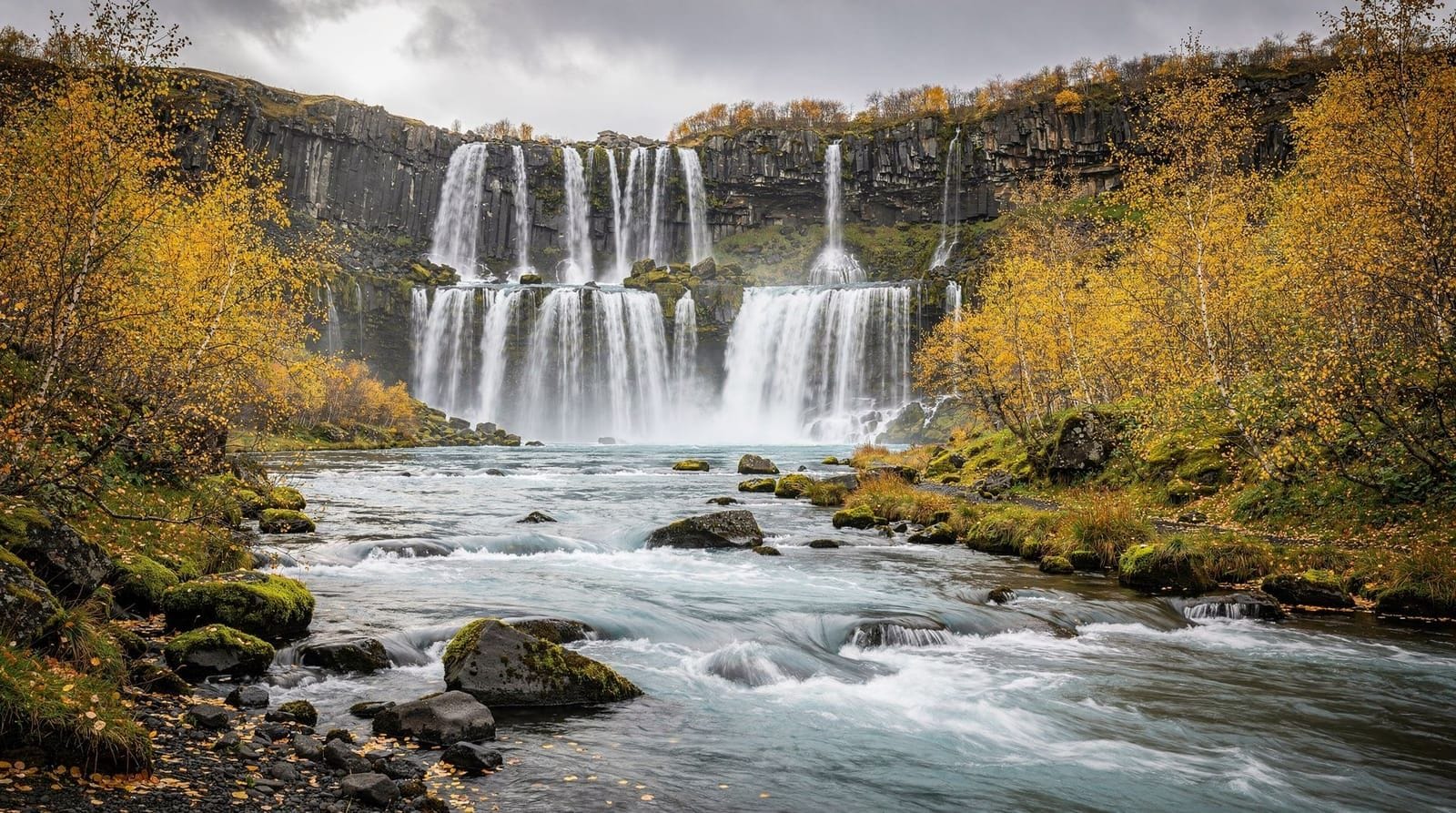
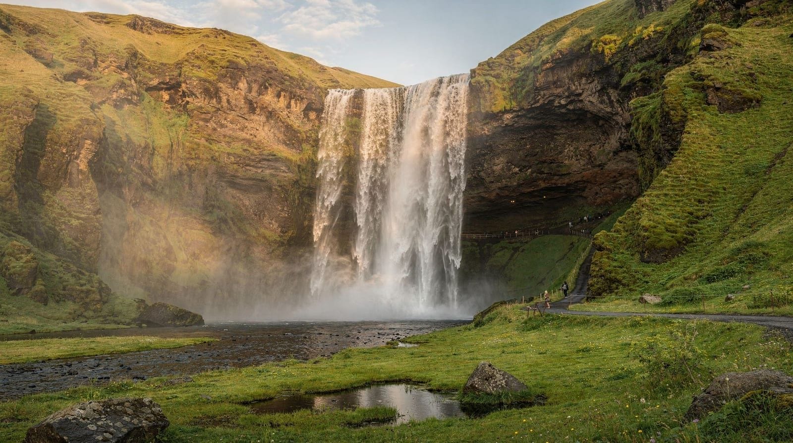
Skógafoss (10:30–11:30)
Skógafoss is 40 km further east (40 minutes). A wide, high-volume waterfall (25 m wide, 60 m drop) with a permanent rainbow in the mist on clear days. The base is accessible within 20 m of the falls; the upper viewing platform requires climbing 430 steps on the eastern staircase (15–20 minutes, views across the valley toward the Fimmvörðuháls ridge).
The Skógar Folk Museum adjacent to the car park is underrated — an open-air collection of preserved Icelandic farmhouses from the 19th and early 20th centuries. Entry around 2,500 ISK (€16). Allow 45 minutes.
Parking: Free at the Skógar campsite car park.
For breakfast or a coffee: the Skógar hotel café is serviceable.
Sólheimajökull glacier (optional, 12:00)
If you have time, a detour north on Route 221 (15 minutes from Skógafoss) reaches the parking area for Sólheimajökull glacier tongue. The glacier is visible from the car park. A 20-minute walk reaches the glacier edge, where you can see the ice up close — without crampons or a guide, you cannot walk on the ice itself, but the view from the moraine ridge above the lake is excellent. This takes 45 minutes–1 hour total as a stop.
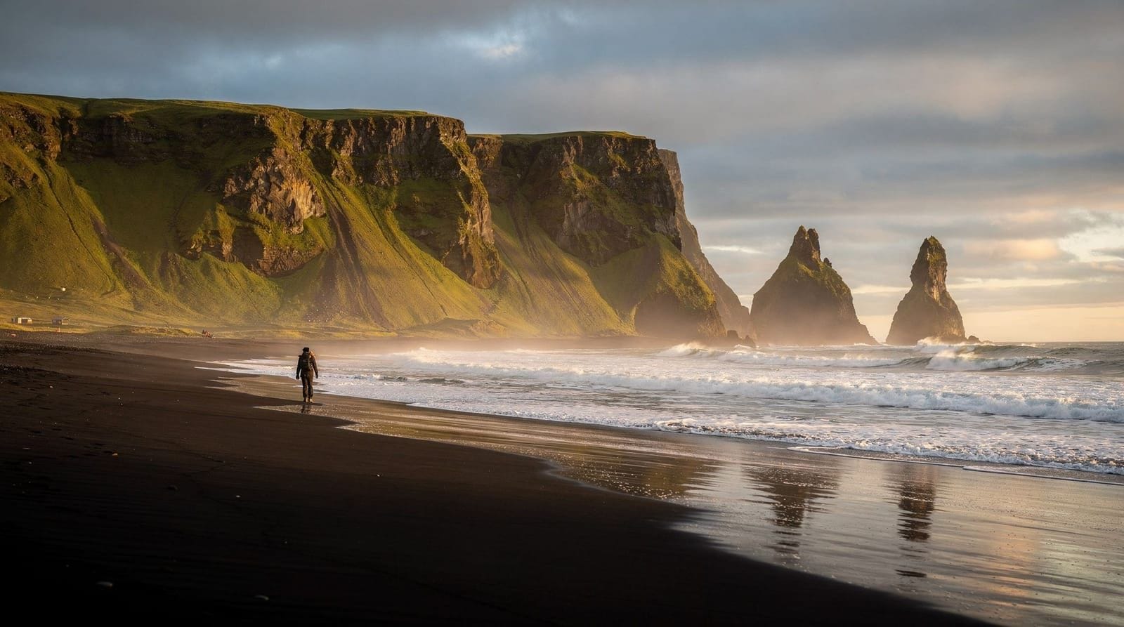
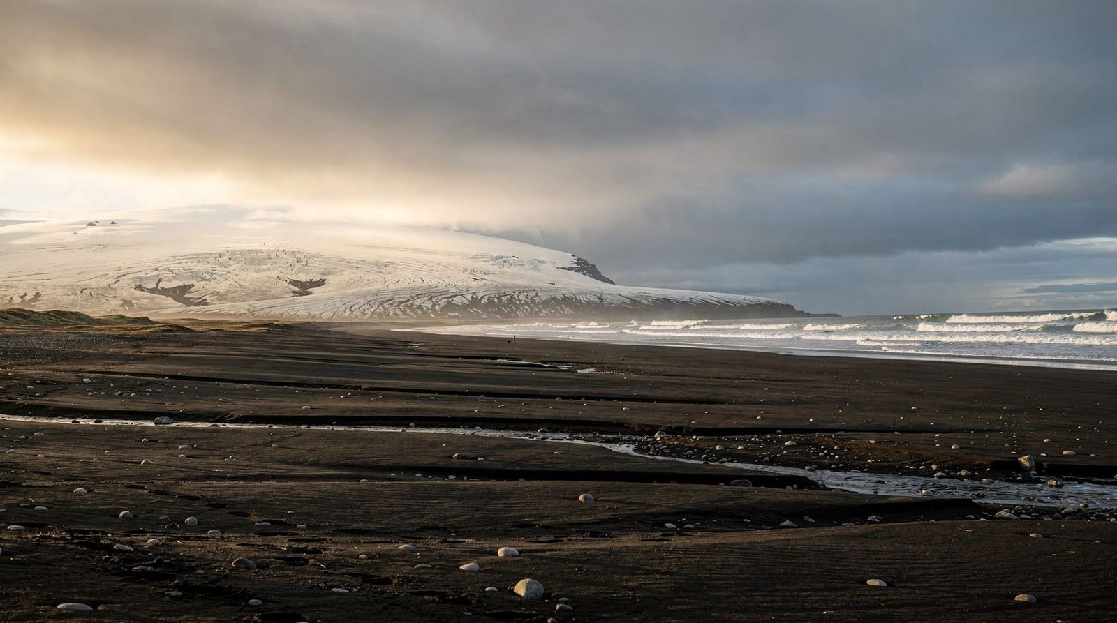
Reynisfjara black sand beach (13:00–14:00)
Reynisfjara is accessed via Route 215 (8 km south of the Ring Road, 30 minutes from Skógafoss). Iceland’s most famous black sand beach, with two specific features beyond the colour: the Reynisdrangar sea stacks rising from the sea just offshore, and a basalt column cave at the eastern end of the beach where the hexagonal columns form a natural staircase and cave ceiling.
Wave safety: This beach has a documented record of visitor deaths from sneaker waves — waves that arrive from calm seas with no warning, with enough force to knock adults off their feet. The beach drops steeply; retreating from a wave is difficult. Rules: stay at least 30 m from the waterline, never turn your back on the sea, watch wave patterns for several minutes before approaching the base of the columns. This is not precautionary language — it applies.
Lunch in Vík: The village of Vík (188 km from Reykjavík) is 8 km east of Reynisfjara. Suður-Vík restaurant is the main dining option — Icelandic lamb soup, fish and chips, good coffee, mains around 2,500 ISK (€16). Halldórskaffi in the old community hall is cheaper and has better baked goods.
Dyrhólaey (14:30–15:30)
Dyrhólaey is a basalt headland west of Vík with a natural sea arch and a lighthouse at the top. The access road climbs steeply to a car park with panoramic views over the black coastal plain and back west toward Reynisfjara. Puffins nest on the western promontory (access restricted May 1–June 25 for breeding season; open later in summer).
Check in to Vík accommodation (15:30–16:00)
Where to sleep in Vík:
- Hótel Kría (Víkurbraut 52): the best hotel in the village, good breakfast, ocean views from some rooms, from 25,000–35,000 ISK (€163–228) in summer
- Black Beach Suites: stylish suites with direct black sand beach views, slightly outside the village, from 30,000–40,000 ISK (€195–261)
- Þakgil campsite (14 km north of Vík): a stunning valley campsite in the mountains above Vík if you’re camping — arguably the best campsite on the South Coast
Book 2–3 months ahead in summer. Vík fills up completely in July.
Day 2: Vík to Jökulsárlón and Diamond Beach
Depart Vík: 07:30–08:00
Total driving today: approximately 190 km one-way (about 2h30), plus return unless you’re staying farther east.
Fjaðrárgljúfur canyon (08:30)
Approximately 30 km east of Vík on Route 1, turn south on Route F206 (signed). This is a gravel road suitable for 2WD in summer. The Fjaðrárgljúfur canyon is 100 m deep, 2 km long, with sheer walls of eroded rock. A walking path follows the canyon rim for approximately 2 km (30–40 minutes return). This is one of the South Coast’s most dramatic detours and is often missed because it requires a deliberate turn off the Ring Road.
Kirkjubæjarklaustur village (09:15)
A useful fuel and coffee stop (68 km east of Vík). The Systrafoss waterfall is a 10-minute walk from the village centre — free, rarely crowded. The Kirkjugólf basalt column floor (near the campsite) is a floor of flat basalt columns that looks like paving stones — an unusual geological formation, 5 minutes from the main road.
Skaftafell / Vatnajökull National Park (10:30–12:00)
Skaftafell is the main access point for Vatnajökull National Park on the South Coast. The visitor centre has good exhibits on the glacier. From the car park (fee: 750 ISK / €5 per vehicle), a 1.5 km walk reaches the Svartifoss waterfall — a distinctive falls bordered by hexagonal basalt columns, the visual reference that inspired the Hallgrímskirkja church design in Reykjavík.
The walk to the Skaftafellsjökull glacier tongue is 3 km return (45 minutes) from the car park — the glacier is visible and approachable. A guided glacier hike can be joined from the glacier car park.
Allow: 1.5–2 hours at Skaftafell.
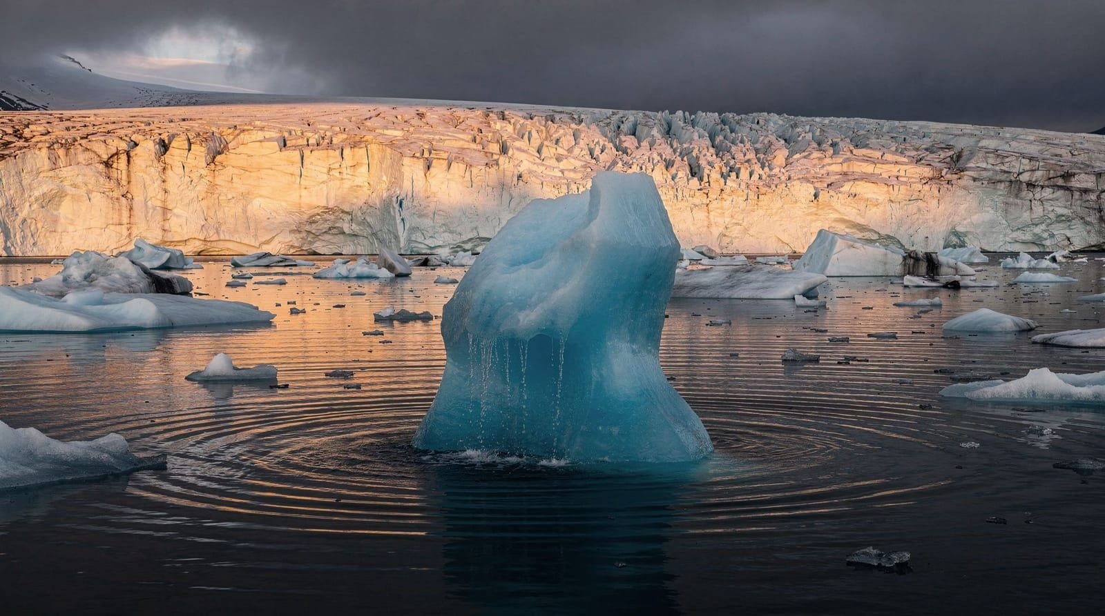
Jökulsárlón glacier lagoon (12:30–14:30)
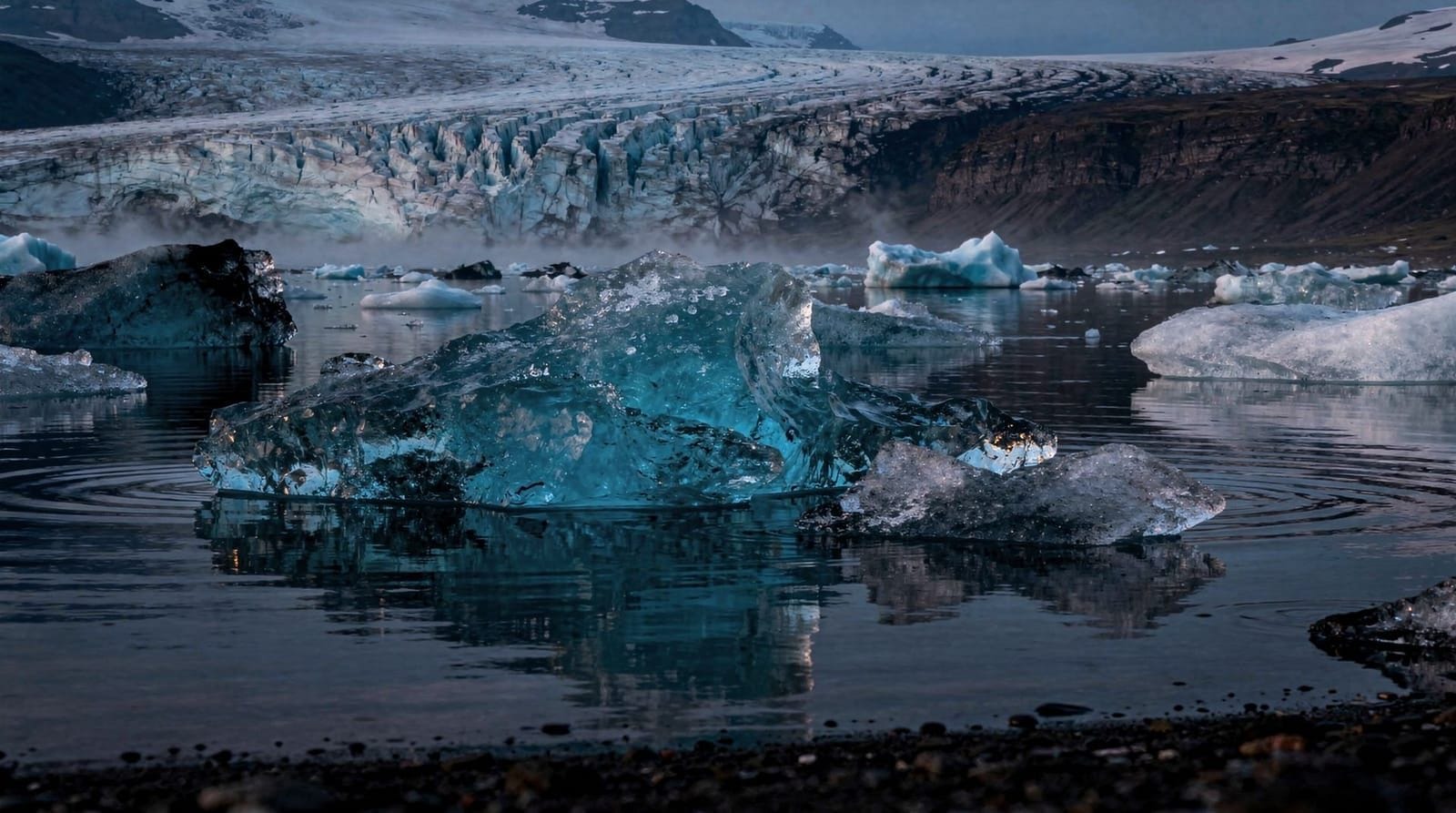
Jökulsárlón is the glacier lagoon where icebergs calve from Breiðamerkurjökull glacier and float in a brackish lake before drifting out to sea. The lagoon is 25 km2, up to 248 m deep, and the bergs range from small fragments to blocks the size of small buildings.
Jökulsárlón glacier lagoon boat tour — 40-minute amphibious or zodiac boat trip among the icebergs, guides explaining the glacier systemThe boat tour is the best way to experience the scale of the lagoon — from the shore, the bergs appear smaller than they are. The amphibious boat circles among floating icebergs and occasionally retrieves ice to demonstrate its age (ice from deeper glacier layers can be thousands of years old).
Café Jökulsárlón at the visitor centre sells soup and sandwiches — a reasonable lunch stop.
Diamond Beach (14:30–15:15)
Diamond Beach is the black sand beach immediately south of the Jökulsárlón bridge, where icebergs that have drifted to sea wash back onto the shore and are left as clear ice chunks on the black sand as the waves retreat. The visual effect — transparent ice blocks scattered across black volcanic sand — is unlike anything else in Iceland. Early morning and late evening have the best light (golden light makes the ice luminous); midday is functional but flat.
Allow: 45 minutes at Diamond Beach. Walk east along the beach for the quieter end.
Return: Jökulsárlón to Vík (15:30 → 18:00)
Return west on Route 1 to Vík. Distance: 185 km, approximately 2h15 driving. The same road, but different light in the evening — the glaciers and mountain backdrop to the north often catch interesting evening light.
Alternatively: If you prefer to continue the ring road eastward, Höfn (75 km east of Jökulsárlón) offers better restaurants and accommodation for a longer trip. This is the logical continuation for the 4-day South Coast itinerary.
Day 3: Return to Reykjavík
Depart Vík: 09:00
The return journey on Route 1 west covers the same ground but time it differently:
- Dyrhólaey at morning light (if you didn’t climb the lighthouse on Day 1)
- Skógafoss in morning sun (east-facing waterfall, well lit before noon)
- Seljalandsfoss again — different light, and if morning means the path behind the falls is less crowded
Return to Reykjavík by 13:30–14:00, allowing for a 09:00 departure from Vík with 1–2 short stops.
Or: take the Blue Lagoon on departure
If your flight leaves Keflavík in the late afternoon, add a 2-hour stop at the Blue Lagoon on the way back from Reykjavík — or better, drive directly from Vík to Blue Lagoon via Route 1 west and Route 41, arriving mid-afternoon, then continue to Keflavík airport.
Where to eat on the South Coast
Vík:
- Suður-Vík restaurant: the main option, reliable Icelandic food, mains 2,500–3,000 ISK
- Halldórskaffi: cheaper café in the old hall, great soup
Kirkjubæjarklaustur:
- Systrakaffi: the main café, decent sandwiches and lamb soup
Skaftafell:
- Skaftafell Bistro: at the visitor centre, sandwiches and soup, adequate
Höfn (if you continue east):
- Pakkhús restaurant: Höfn is known for langoustine — this is the best langoustine restaurant on the South Coast, mains 4,000–6,000 ISK (€26–39)
Fuel stations on the South Coast
- Selfoss (40 km from Reykjavík): N1, full service
- Hvolsvöllur (100 km): N1, ATM
- Vík (188 km): N1 petrol station with a bakery that’s better than average
- Kirkjubæjarklaustur (250 km): N1
- Höfn (460 km from Reykjavík): N1
Note on fuel prices: Iceland fuel costs 230–250 ISK per litre (€1.50–1.63). At an average rental car consumption of 7–8 litres per 100 km, the 750 km return trip costs approximately 13,000–15,000 ISK (€85–98) in fuel.
Frequently asked questions about this 3-day Iceland itinerary
Is the South Coast suitable in winter?
Yes — winter conditions make the South Coast more dramatic rather than less. Skógafoss partially frozen, snow on the coastal plain, and low winter light are all genuinely good photographic conditions. However: winter tyres are legally required, storm days can close roads temporarily, and Seljalandsfoss behind-the-falls path is often iced shut. Check road.is before each day’s drive. See the driving in Iceland guide for winter specifics.
Do I need to book accommodation in Vík in advance?
Yes, significantly in advance. Vík has limited accommodation capacity relative to the number of visitors it receives in summer (June–August). Book 2–3 months ahead minimum. Alternatives if Vík is full: Hvolsvöllur (100 km west, better supply of guesthouses) or Kirkjubæjarklaustur (70 km east, fewer options but less demand).
What is the best time to visit Jökulsárlón?
Early morning and late evening give the best light on the icebergs. In summer, this means arriving before 09:00 or after 17:00 for calmer conditions and fewer people. The lagoon is also dramatic in winter, when the surface can be partially frozen and the icebergs are dusted with snow. The boat tour operates May–October.
Should I do the boat tour at Jökulsárlón?
Yes, if you can. The shore view is spectacular, but the boat tour provides scale and context that you cannot get from land — you understand how large the icebergs are when you’re floating alongside them. The amphibious boat tour (shorter, less specialised) is the standard option; zodiac tours go faster and get closer to the glacier face.
How far is Jökulsárlón from Reykjavík?
375 km via Route 1, approximately 4.5–5 hours of driving without stops. As a day trip from Reykjavík it is possible but exhausting (750 km return). A 3-day itinerary with overnight stays is significantly better.
Can I walk on the icebergs at Diamond Beach?
No. The ice on Diamond Beach is unstable — it has been polished smooth by the sea and can roll unexpectedly. Walking on beach ice is prohibited and dangerous. View from the sand.
Packing list for the South Coast self-drive
The South Coast has specific conditions that differ from a city visit:
Waterproofs: essential at Seljalandsfoss (behind-the-falls path soaks you in mist), useful at Gullfoss (spray on windy days), and advisable throughout given the frequency of coastal rain. A proper waterproof jacket and trousers are more practical than a single “rain jacket.”
Footwear: waterproof shoes or hiking boots with ankle support. The path behind Seljalandsfoss is wet rock and gravel; Reynisfjara beach has uneven black sand; Skaftafell trails are gravel. Trainers are inadequate for the day’s range of surfaces.
Warm layer: South Iceland coastal temperatures are 10–15°C in summer, with the wind chill reducing it further near the coast. A fleece or down mid-layer between base and waterproof is practical from May through September.
Sunglasses and sun protection: the low-angle summer sun on the South Coast creates strong glare, particularly at Jökulsárlón and Diamond Beach where the ice reflects the light. This is counterintuitive for a trip to Iceland; sun protection matters nonetheless.
Cash: rare to need it, but the Þakgil campsite (13 km north of Vík) sometimes requires cash payment. Fill up with ISK before leaving Reykjavík if you plan on remote stops.
Offline maps: download the offline map for the South Coast region in Google Maps or Maps.me before departing Reykjavík. 4G coverage is good along Route 1 but absent on some secondary roads (Þakgil, Fjádrargljúfur, Skaftafell side roads).
The South Coast in winter
The South Coast is open and accessible year-round, with conditions that are different rather than simply worse in winter:
What is better in winter: Skógafoss partially frozen creates sculptural ice formations at the base and on the cliff face. The black sand beaches with snow are visually striking. The glacier views from the Ring Road have more contrast. Visitor numbers are significantly lower — Reynisfjara in February has a fraction of the summer crowds.
What is worse or different: Seljalandsfoss behind-the-falls path is often iced and closed (November–April). Daylight is limited — December gives 4–5 hours of useful daylight, which is enough for 2–3 stops but not a full 6-stop day. Road conditions require winter tyres (legally mandatory) and more cautious driving. The fjord and glacier roads close occasionally during severe weather.
Winter-specific addition: the Katla ice cave near Vík is accessible year-round and particularly good in winter when the cave has more stable ice. This is the logical winter alternative to the Vatnajökull natural caves (also accessible October–March but 5 hours further east). See the Iceland in winter driving guide for full seasonal logistics.
Driving on Route 1 — practical notes
Route 1 (Ring Road) between Reykjavík and Jökulsárlón is fully paved and well-maintained. Some specific driving notes for the South Coast section:
Single-lane bridges: there are several single-lane bridges on the South Coast, particularly east of Vík. Yield to oncoming traffic on these; the protocol is first car to the bridge has priority. They are signed; slow down well before the bridge.
Sheep on the road: from June through August, sheep graze freely in Iceland and regularly wander onto roads, including Route 1. Drive below the speed limit near farms, particularly in twilight and at dawn. Collisions with livestock are common and the driver is legally responsible.
Speed cameras: Iceland has fixed speed cameras at regular intervals. The limit of 90 km/h on open roads is actively enforced. The fine for a 20 km/h excess is approximately 18,000 ISK (€117).
Fuel at night: not all fuel stations have attended service after 18:00. All major N1 and Orkan stations are 24-hour self-service with card payment. Know where the next station is before driving into the evening.
Top experiences
Bookable activities with verified prices and instant confirmation on GetYourGuide.