Dyrhólaey — sea arch, puffins, and the edge of Iceland
Guide to Dyrhólaey promontory — Iceland's dramatic sea arch, puffin cliffs, lighthouse panoramic views, and practical access tips including seasonal closures.
Reykjavik: South Coast highlights small group
Quick facts
- Best time
- May–Aug for puffins; sea arch visible year-round
- Days needed
- 1–2 hours (combine with Reynisfjara and Vík)
- Getting there
- ~2h 15min from Reykjavík; 10 km west of Vík off Route 1
- Budget per day
- Free entry; combine with South Coast for 12,000–20,000 ISK / €80–130
Dyrhólaey (pronounced roughly “deer-hoh-lay-ee,” meaning “the hill island with the door hole”) is a volcanic promontory on the South Coast about 10 km west of Vík. Its name describes its defining feature: a large natural arch in the cliff face, large enough that small aircraft have reportedly flown through it — a feat now illegal and inadvisable. The promontory also hosts one of the most accessible Atlantic puffin colonies on the entire South Coast.
The site is managed as a nature reserve, and portions close annually from May to mid-June to protect nesting puffins. Access is free but subject to seasonal restrictions.
The sea arch
The arch at Dyrhólaey is not something you can walk through — it sits in the cliff face at sea level, accessible only by boat or from a viewpoint above. The lower parking area gives you a ground-level view of the arch from the adjacent beach (approximately 200 metres from the arch itself), while the upper road to the lighthouse provides a high perspective looking down across the entire promontory.
The arch itself is roughly 15–20 metres high and carved by wave erosion through the basalt cliff. The geometry changes dramatically with the tide and sea state — at low tide in calm conditions the structure is clearly defined; in rough weather the arch disappears periodically under white water.
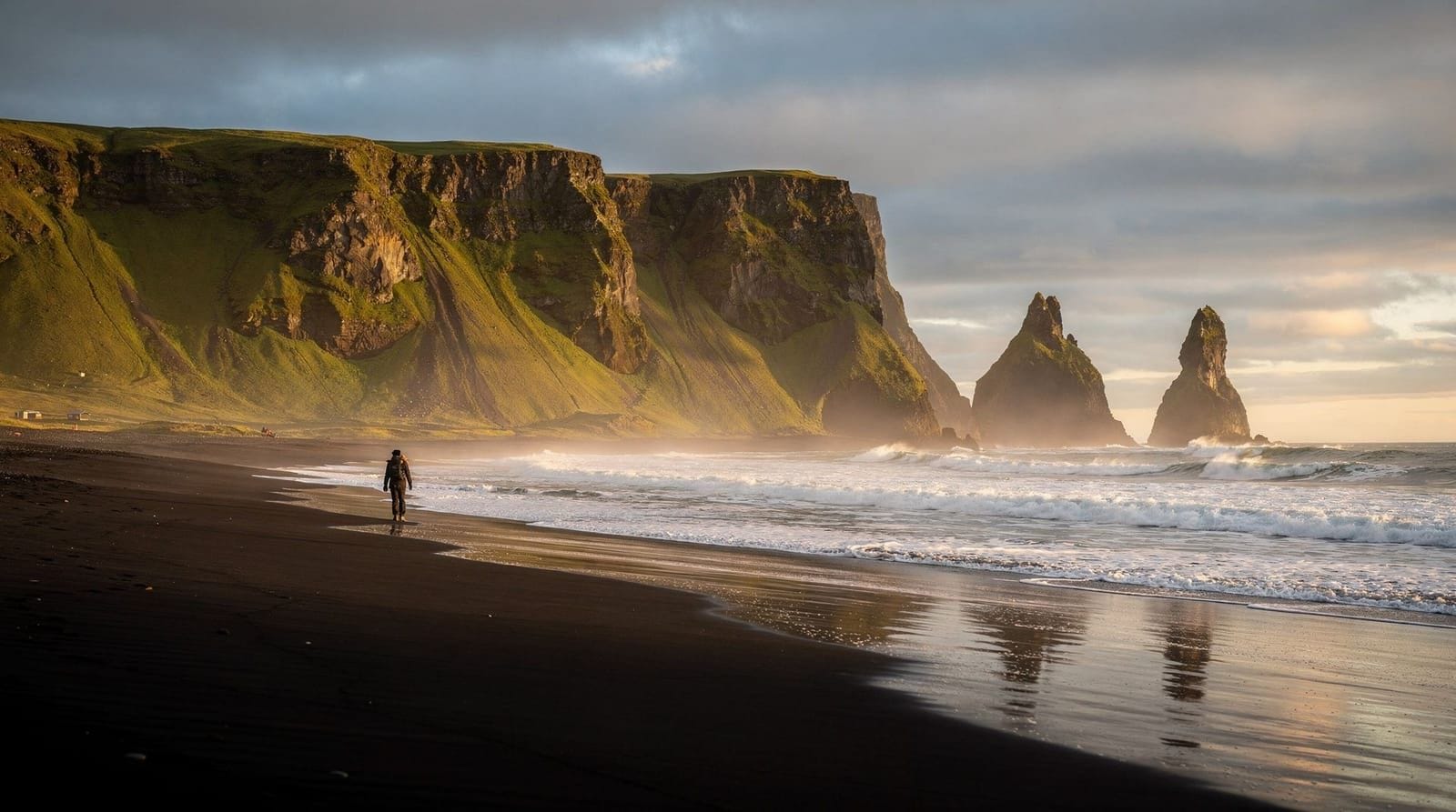
For photography, the upper viewpoint is more satisfying compositionally: you can frame the arch with the black sand beach and the Reynisdrangar sea stacks visible in the background on a clear day. The lower viewpoint is better for scale comparison and when the sea is active.
Puffin watching
Dyrhólaey is one of the most reliable spots on the South Coast for seeing Atlantic puffins. The colony nests on the grassy clifftop around the lighthouse from mid-May to approximately mid-August. At peak season (June–July), hundreds of puffins can be visible from the lighthouse access road and the promontory path.
The birds are relatively habituated to visitors but should not be approached within 3–4 metres, and you should never approach burrow entrances. Puffins are smaller than most people expect (roughly the size of a large coffee mug standing up), and they tend to land in evening. The best viewing hours are typically from 8pm to 10pm in summer.
Seasonal closure: The lower access road and beach at Dyrhólaey closes annually between roughly 1 May and 25 June to protect nesting ground birds. The upper road to the lighthouse typically remains open with some restrictions. Check the Environment Agency of Iceland (ust.is) for the specific dates each year, as they vary. Visiting the area during the closure is not permitted, though the surrounding roads and Reynisfjara remain accessible.
The lighthouse and upper viewpoint
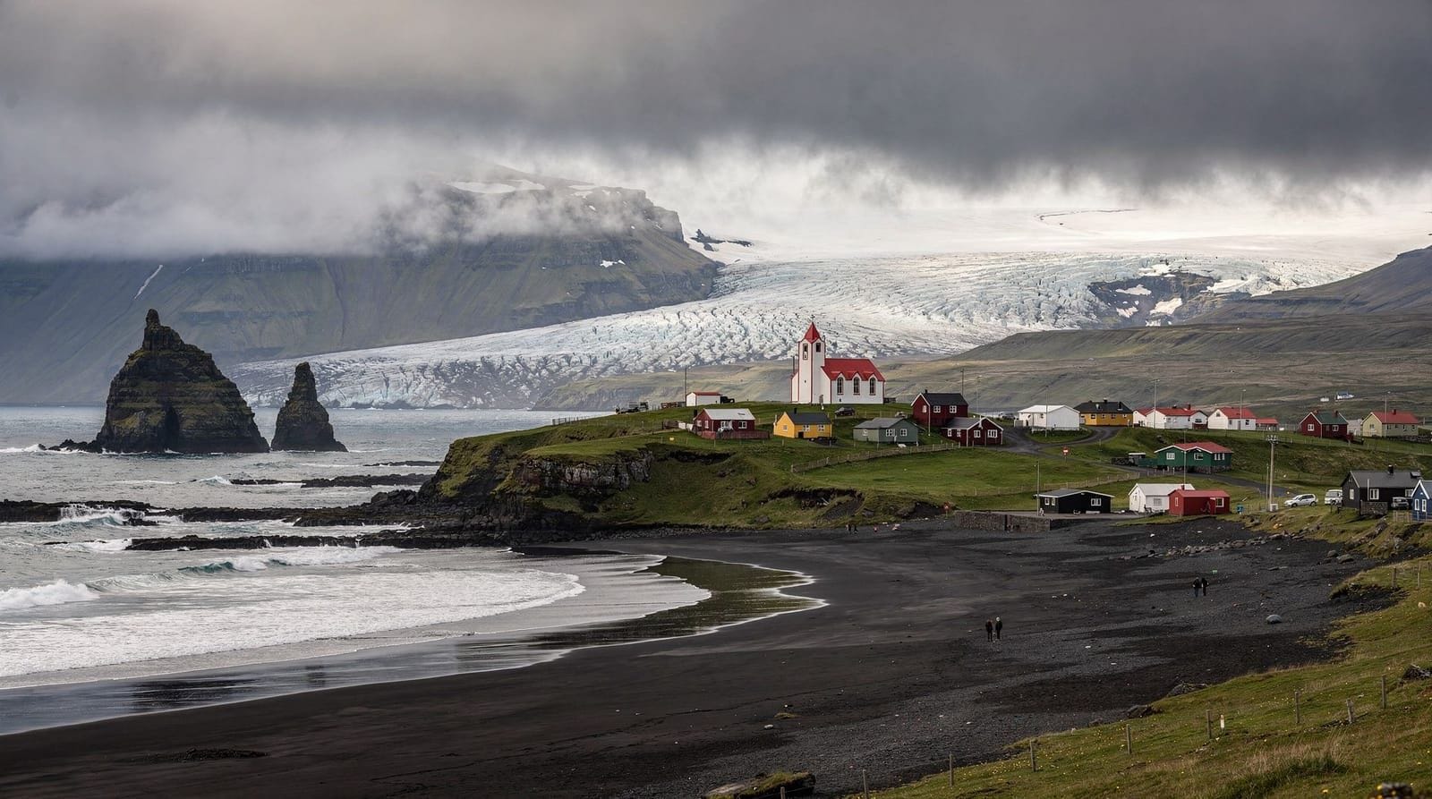
The upper access road winds to the top of the promontory where a white lighthouse (Dyrhólaeyarviti) sits at the highest point. The view from here is one of the most panoramic on the entire South Coast: looking east, you can see the Reynisdrangar stacks and Vík on a clear day; west, the coast extends toward Seljalandsfoss; inland, the Mýrdalsjökull glacier cap is visible above the coastal plain.
On clear days with a good telephoto lens (300mm or longer) you can photograph the sea arch from above at the lighthouse, with the arch framed against the open ocean.
The road to the lighthouse is paved but narrow. In summer it can become congested with camper vans and is sometimes one-way managed on busy days. Allow extra time and turn around if traffic is backed up — the wait is usually short.
Combining Dyrhólaey with Reynisfjara and Vík
The three sites — Dyrhólaey, Reynisfjara, and Vík — form a natural cluster separated by 5–10 km each. A logical half-day covers all three:
- Dyrhólaey upper viewpoint and lighthouse (45 minutes)
- Reynisfjara black sand beach and basalt columns (45–90 minutes)
- Vík village for lunch or supplies (30 minutes)
This can be done in either direction; most eastbound travellers hit Dyrhólaey first (it is the westernmost) before stopping at Reynisfjara and Vík. Most commercial South Coast tours combine these three sites as a unit.
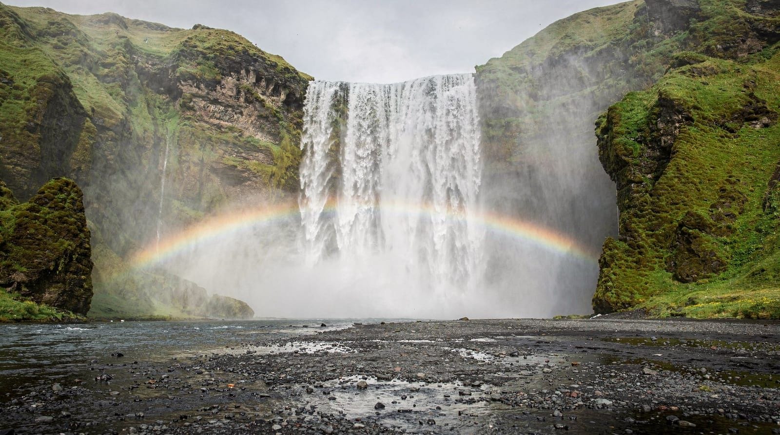
The South Coast 3-day itinerary treats these sites as the first afternoon of the trip, arriving from the west after visiting Seljalandsfoss and Skógafoss in the morning.
South Coast highlights small-group tour from Reykjavík — Dyrhólaey, Reynisfjara, and the main waterfallsPractical information
Parking: There are two separate car parks: lower (near the beach and arch viewpoint) and upper (near the lighthouse). Both are free. The lower car park is the one affected by the seasonal nesting closure.
Access road: The upper road is accessible to normal cars. Some sections have a steep gradient but are paved throughout. In winter, the road can be icy and is occasionally closed; check road.is before visiting between November and April.
Facilities: There are no toilets or cafes at Dyrhólaey itself. The nearest facilities are in Vík (10 minutes east), which has a supermarket, petrol station, and restaurants.
Weather: The promontory is fully exposed to Atlantic weather and can be significantly windier and wetter than the surrounding lowlands. On stormy days the arch viewpoint is spectacular but hard to photograph — the spray reaches the cliff tops.
Walking and the coastal path
A coastal walking trail connects Dyrhólaey with the Reynisfjara area — approximately 6–7 km along the cliffs. The trail is not fully marked and involves some route-finding; it is not recommended without local knowledge or a GPS track. The geology along this coastline includes eroding cliffs and unstable edges in places. If you want to walk between the sites, confirm current trail conditions with the visitor centre in Vík.
Dyrhólaey in winter
In winter, the puffins are gone (they spend winter at sea) but the landscape has a raw quality that many photographers prefer. The arch frequently has ice formations at the base, the waves are larger and more dramatic, and the light — when it appears — is low and golden even at midday. Snow on the surrounding cliffs is common between December and March.
The promontory is accessible in winter except during road closures. The seasonal nesting restriction does not apply (it is a spring/summer measure), so the lower beach area is open. Winter visits require warm clothing and good footwear — the wind chill at the cliff top is extreme.
Winter also brings the possibility of Northern Lights visible from the promontory. The area around Vík and Dyrhólaey has very low light pollution, and on clear nights between September and March aurora activity can be significant. The lighthouse area provides an unobstructed northern horizon — important for aurora viewing — and the arch below provides a foreground for photography that is genuinely distinctive.
The northern lights winter 5-day itinerary routes through this area specifically for aurora hunting from the south coast.
Geology: why Dyrhólaey looks the way it does
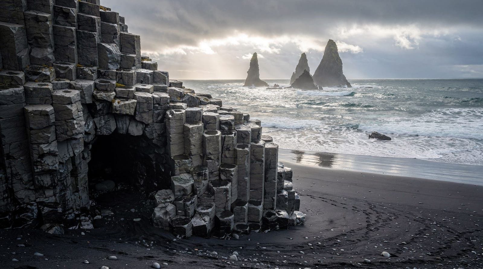
Dyrhólaey is a tuya — a volcanic formation created when a subglacial eruption built up a flat-topped lava plateau beneath an ice sheet, then was exposed as the glacier retreated. The flat-topped promontory shape, the vertical cliff faces, and the coastal arch are all products of this specific formation process: lava poured out under pressure from above, cooled against glacial melt, and created a table-like structure.
The basalt here is the same material you see at Reynisfjara — the same Mýrdalsjökull volcanic system — but the exposure pattern and erosion history differ slightly. At Dyrhólaey the cliff faces are more vertical and the wave erosion has progressed to the point of creating the arch, while at Reynisfjara the hexagonal columns are better exposed in cross-section.
Understanding this geology adds significant context to the landscape. The flat top of Dyrhólaey, the sheer drops, the arch — all are explained by the same ice-volcanic interaction that shaped most of the South Coast’s dramatic landforms.
Dyrhólaey versus Reynisfjara: which to prioritise?
If you have time for only one stop in the Vík cluster, the choice depends on your priorities:
For geology and beach atmosphere: Reynisfjara — the basalt column cave and the beach scale are more accessible and photogenic.
For puffins and panoramic views: Dyrhólaey — especially if timing your visit for evening in June or July. The lighthouse viewpoint over the entire coast is the better big-picture perspective.
For photography: Both are necessary for different reasons. Dyrhólaey gives the wide coastal panorama and the arch (from distance); Reynisfjara gives close-up basalt geometry and the beach texture.
Most itineraries include both. The South Coast 3-day itinerary allocates the afternoon of day one to the Dyrhólaey-Reynisfjara-Vík cluster, treating them as a unit rather than separate stops.
Accommodation near Dyrhólaey
No accommodation exists at Dyrhólaey itself. Vík (10 km east) is the nearest practical base, with several guesthouses and hotels. The Hótel Kría in Vík is the largest option (reliable, modern, 35,000–45,000 ISK / €230–290 in high season); smaller guesthouses are available at 20,000–28,000 ISK (€130–185).
Staying in Vík rather than driving from Reykjavík allows early morning access to Dyrhólaey before the tour buses arrive, which transforms the experience — the lighthouse promontory in morning mist with few other visitors is a very different proposition from the midday crowd.
For a budget option, the campsite at the Systrastapi farm (~5 km east of Vík) offers basic facilities at around 2,500 ISK (€16) per person per night and is within cycling distance of Dyrhólaey.
Iceland South Coast day tour — Dyrhólaey, Reynisfjara, and the black sand beaches in one guided dayWhat to photograph at Dyrhólaey: practical angles
Dyrhólaey offers at least four distinct photographic compositions unavailable elsewhere on the South Coast:
The arch from the lower beach: A medium-wide lens (24–35mm) from the west end of the lower beach captures the arch in its full sea context. Best in morning when the sun is to the east and the arch face is illuminated. The basalt column formations on the cliff face flanking the arch provide leading lines.
Looking back east from the lighthouse: A telephoto (200–400mm) from the lighthouse viewpoint toward Reynisfjara compresses the distance and shows the black sand coastline, the Reynisdrangar stacks, and the coastal plain in a single frame. Available year-round; best when the atmosphere is clear (winter and early spring tend to have better visibility).
Puffins on the clifftop: In June and July, puffins land on the grassy areas near the lighthouse. A 300mm or longer lens allows frame-filling shots without disturbing the birds. The challenge is that puffins move constantly — patience at a fixed viewpoint works better than trying to approach. The clifftop background (open sea below) gives cleaner separation than shooting against the land.
The arch from a boat: A handful of sea kayak and small boat operators run tours from nearby beaches that pass close to or through the arch in calm conditions. This gives an angle unavailable from land. Contact the Vík area tourist information for current operators.
Dyrhólaey and the South Coast bird migration
Beyond puffins, Dyrhólaey’s position at the southernmost point of Iceland’s mainland makes it a notable location during spring and autumn bird migration (April–May and August–October). Unusual species occasionally appear during migration periods — rare vagrant passerines are recorded here more consistently than at most South Coast sites.
The Environment Agency (ust.is) and the Icelandic Bird Society (fuglar.is) post recent sightings. If birdwatching is a specific interest, the autumn migration window (late July to mid-October) is the best time to be at Dyrhólaey — the nesting restrictions are over, the crowd is smaller, and the diversity of species is higher than at any other time of year.
Razorbills and guillemots nest on the Reynisdrangar stacks (visible from the arch viewpoint) in addition to the puffin colony on the promontory. The cliff habitat at the base of Dyrhólaey also supports a small population of northern fulmars year-round.
Frequently asked questions about Dyrhólaey
When is Dyrhólaey closed for nesting birds?
The lower beach and access road typically close from around 1 May to 25 June to protect ground-nesting birds. The upper lighthouse road usually remains open. Exact dates change each year — check ust.is (Environment Agency of Iceland) before visiting in May or early June.
Can you walk through the Dyrhólaey arch?
No. The arch is in the cliff face at sea level and is only accessible by water. You can view it from the adjacent beach (lower parking) or from above at the lighthouse. Small boat tours occasionally pass through the arch in calm weather.
Are puffins visible at Dyrhólaey?
Yes — it is one of the better puffin-viewing sites on the South Coast. The colony is present from mid-May to mid-August. Best viewing is from the lighthouse promontory, particularly in the evening (8–10pm in summer) when birds return from fishing. Binoculars are helpful.
How do I get to Dyrhólaey?
Turn off Route 1 at the signed junction approximately 10 km west of Vík. There are two separate roads — one to the lower beach area and one to the upper lighthouse. Both are signposted from the Route 1 turnoff. The upper road is the one to prioritise if the lower is seasonally closed.
Is Dyrhólaey worth visiting without puffins?
Yes. The sea arch, the panoramic coastal views from the lighthouse, and the dramatic basalt geology are worth the stop regardless of season. Winter visits offer the most dramatic sea conditions; spring visits coincide with the first puffins returning.
How long should I spend at Dyrhólaey?
Most visitors spend 45–60 minutes. If you are specifically there for puffin photography, plan 1.5–2 hours and time your visit for the evening. The arch viewpoint is quick — 15–20 minutes including the walk from the car park.
How far is Dyrhólaey from Reykjavík?
About 160 km east via Route 1, a drive of approximately 2 hours 15 minutes in standard conditions. Most South Coast day trips from Reykjavík include Dyrhólaey as part of a multi-stop itinerary.
Top experiences
Bookable activities with verified prices and instant confirmation on GetYourGuide.

Top-rated experiences in Dyrhólaey — sea arch, puffins, and the edge of Iceland
Best-rated activities across GetYourGuide and Viator.