Katla ice cave tour — the year-round alternative near Vík
Vik: Katla ice cave super jeep Vik
Can I do Katla ice cave in summer?
Yes — Katla's geothermal ice caves are open year-round, unlike Vatnajökull's natural blue ice caves which are winter-only (November–March). The geothermal heat from Katla volcano creates caves that are structurally stable regardless of season, making them the best option for summer ice cave experiences.
What makes Katla ice cave unique
Most discussion of ice caves in Iceland centres on Vatnajökull — the blue ice, the winter-only access, the spectacular photographs. Katla’s ice caves are different in almost every respect, and those differences make them worth understanding on their own terms.
Katla is one of Iceland’s most powerful volcanoes, sitting beneath Mýrdalsjökull glacier about 20 km east of Vík. The volcano has erupted roughly every 40–80 years historically, and its last major eruption in 1918 caused a catastrophic glacial outburst flood that deposited millions of tonnes of debris on the south coast. The evidence of that eruption is visible in the ice caves today — thick layers of black ash embedded in the ice walls.
The caves form not from cold-meltwater erosion (like Vatnajökull’s natural caves) but from geothermal heat rising through the volcanic system beneath. This heat melts channels from the inside, creating cavities that remain stable year-round because the thermal dynamic doesn’t change with the seasons. The result is one of the only places in Iceland where you can stand inside a glacier regardless of what month it is.
The visual experience
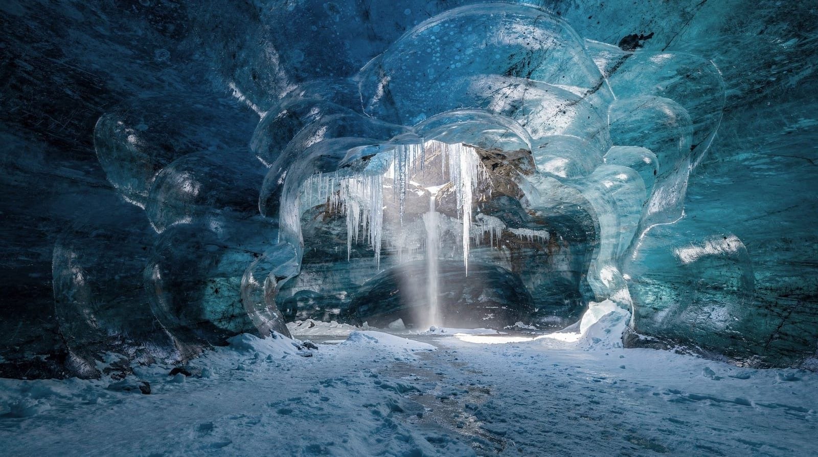
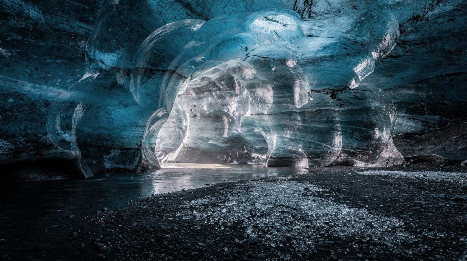
If you’re expecting Vatnajökull’s vivid blue ice inside Katla’s caves, you’ll need to adjust expectations. The caves here are geologically distinct:
Volcanic ash: Thick horizontal bands of black and grey ash run through the ice walls — exactly as they do on Sólheimajökull’s surface. Each dark layer represents a specific Katla eruption; the 1918 layer is particularly prominent. In some sections, the ash concentration is high enough that the ice appears nearly black.
Cleaner blue sections: Not all the ice is dark. Where ash concentration drops, the compressed glacial ice displays the same blue-white characteristics as Vatnajökull. These sections contrast dramatically with the adjacent dark ice.
Textures: The geothermal environment creates unusual surface textures on the cave walls — ripples, whorls, and melt patterns that look less like solid ice and more like a slow-moving liquid frozen mid-flow.
Size: The caves tend to be smaller and more intimate than the largest Vatnajökull formations. Chambers of 3–6 metres height are typical. This can feel claustrophobic to some visitors; others find the enclosed scale more photogenic than vast chambers.
Getting to Katla ice cave
From Vík: The most convenient base. Vík is a small south coast town about 185 km east of Reykjavík, with several hotels and guesthouses. Most Katla cave operators are based here and run frequent departures — typically 09:00, 11:00, 13:00, and 15:00. The jeep from Vík to the cave entrance takes about 25 minutes across the glacier approach.
From Reykjavík by car: Drive Route 1 east for approximately 2 hours. You can arrive in Vík for a morning or afternoon cave tour and return to Reykjavík the same day, though this makes for a full 10–12 hour day when combined with other south coast stops.
From Reykjavík by guided bus tour: Multiple operators offer south coast + Katla ice cave day tours departing Reykjavík early morning (7:00–8:00) and returning by evening. These typically include Seljalandsfoss, Skógafoss, Reynisfjara, and the ice cave — a packed day with limited time at any single location.
Staying in Vík: If you want more time on the south coast, staying one or two nights in Vík makes sense. You can do the cave tour from Vík in the morning, visit Dyrhólaey and Reynisfjara in the afternoon, and continue east toward Skaftafell the following day.
South coast + Katla ice cave small group from Reykjavík
The tour experience step by step
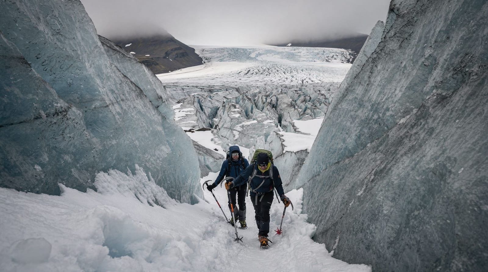
Tours assemble at a meeting point in or near Vík. You’re typically transferred by modified super-jeep — a vehicle with oversized tyres running at low pressure for traction on the glacier surface. The approach to the cave involves a 20–30 minute drive across the glacier, which is an interesting experience in itself — the vehicle handles terrain that would be impossible in a standard 4x4.
At the cave entrance, helmets and crampons are fitted if the approach requires it (some caves are accessed across icy terrain). The guide explains basic safety: stay together, don’t touch ice formations, follow the marked route.
Inside the cave: guides typically spend 30–45 minutes explaining the geology and photographing with the group at key sections. The volcanic ash layers generate the most discussion — guides can walk you through the approximate history of Katla eruptions embedded in the cave walls. Time in the cave is usually well-structured but not rushed.
The return jeep ride often pauses for additional south coast views or, in winter, northern lights if conditions are right.
Katla cave vs. Vatnajökull cave
Here’s an honest comparison for the common decision:
| Katla | Vatnajökull | |
|---|---|---|
| Season | Year-round | Nov–Mar only |
| Ice colour | Dark grey/black with blue sections | Vivid blue/white |
| Cave size | Intimate (smaller) | Can be large |
| Drive from Reykjavík | 2 hours | 5 hours |
| Cost | 12,000–18,000 ISK | 15,000–25,000 ISK |
| Cancellation risk | Low (stable year-round) | Higher (weather/structural) |
Choose Katla if you’re visiting outside November–March, you’re staying on the south coast, or you want to combine an ice cave with nearby activities like Sólheimajökull glacier hiking.
Choose Vatnajökull if you’re visiting in December–February, you’re based in the south-east, and you want the classic blue ice aesthetic that Iceland ice caves are most famous for.
Katla ice cave + south coast day tour from Reykjavík
Safety and the Katla question
Every operator in the Katla area monitors seismic activity through Iceland’s Meteorological Office (Veðurstofa Íslands). Tours are immediately suspended when seismic thresholds are exceeded. This is not a theoretical risk management exercise — operators have cancelled tours and evacuated the area during periods of elevated Katla activity. The monitoring infrastructure is robust and taken seriously.
For visitors, the practical implication is: book with an established operator, check their cancellation policy for seismic events (should be full refund), and trust the system. Iceland’s civil protection authorities are experienced at managing this specific risk.
The cave structures themselves are not dependent on a stable sub-zero temperature, which makes them safer year-round than cold-meltwater natural caves. They don’t have the ceiling stability concerns that Vatnajökull caves face in spring. The primary structural risk at Katla caves is from geothermal event escalation, which is monitored continuously.
Combining Katla with other south coast activities
The Katla area naturally clusters with south coast day trip activities:
- Seljalandsfoss waterfall (you can walk behind it) — about 60 km west of Vík
- Skógafoss waterfall — about 30 km west of Vík
- Sólheimajökull glacier — 15 km west of Vík
- Reynisfjara black sand beach — 4 km from Vík
- Dyrhólaey headland and arch — 10 km from Vík
Combining a 09:00 Katla cave tour with afternoon south coast stops, then returning to Reykjavík by 20:00, is achievable if you’re driving and move efficiently. Don’t try to add Skaftafell or Jökulsárlón on the same day — it’s too far.
The geology of Katla and Mýrdalsjökull
Understanding what you’re entering at Katla adds significant depth to the experience. Mýrdalsjökull is an ice cap covering approximately 600 square kilometres, and beneath it lies Katla — a caldera volcano roughly 10 km in diameter, one of Iceland’s most powerful and most active volcanic systems.
Katla’s eruption history goes back to the settlement of Iceland in the 9th century, with major eruptions documented approximately every 40–80 years. The 1918 eruption was catastrophic: it produced a jökulhlaup (glacial outburst flood) with a discharge estimated at 200,000–300,000 cubic metres per second — comparable to the Amazon River’s entire flow, released in less than a day. The flood deposited sediment that extended the south coast of Iceland by several kilometres.
The geothermal heat from Katla continuously melts ice at the base of Mýrdalsjökull. This subglacial meltwater accumulates in sub-glacial lakes. When seismic activity increases, these lakes can drain suddenly, producing smaller jökulhlaups. Several such events occurred in the 2000s and 2010s.
The ice caves formed in this system owe their existence to the geothermal heat: steam and warm water carve channels from beneath the ice, leaving hollow spaces that progressively enlarge. The dark ash visible in the cave walls is volcanic material from past Katla eruptions that was deposited on the glacier surface and then incorporated into the ice over subsequent snowfall seasons.
Vík — the south coast hub
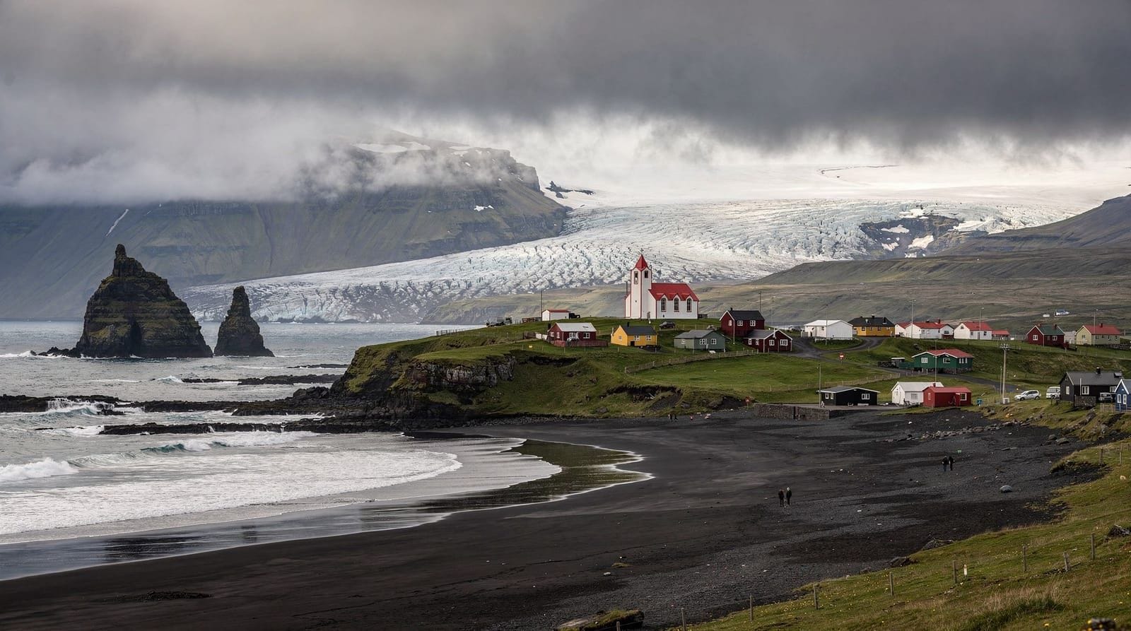
Vík is the logical base for Katla ice cave visitors and deserves mention as a destination in its own right. The town is Iceland’s southernmost village, sitting at the base of the Mýrdalur valley with Reynisfjara black sand beach 4 km to the west and Dyrhólaey headland just beyond.
Where to stay: Vik’s accommodation options have grown substantially as the south coast has become a major tourist route. Hótel Vík, Icelandair Hotel Vík, and multiple guesthouses are available. For budget travellers, the local campsite (open May–September) is well-positioned.
Reynisfjara black beach: One of Iceland’s most striking landscapes, 4 km west of Vík. The beach is famous for its basalt column formations (Garðar) and the dramatic sea cave (Hálsanef). It’s also famous for sneaker waves that have killed tourists who stood too close to the water — the warning signs are serious and should be heeded.
Dyrhólaey: A basalt headland with a natural arch visible from the coast. Puffin colony visible here in summer (April–August). The road to the headland viewpoint is closed during nesting season to protect the birds.
Combining with Sólheimajökull: The Sólheimajökull glacier is 15 km west of Vík, about 20 minutes by car. A morning glacier hike followed by an afternoon Katla ice cave tour, then Reynisfjara in the evening, is an excellent full south coast day for visitors staying in Vík.
Katla monitoring and what it means for your visit
The monitoring of Katla is conducted by the Icelandic Meteorological Office (Veðurstofa Íslands) using a network of seismometers, GPS stations, and radar instruments on and around the glacier. The monitoring data is publicly available and updated in real time — visitors can check current seismic status at vedur.is.
Iceland’s civil protection system (Almannavarnir) maintains a colour-coded alert system for volcanic areas. For the Katla/Mýrdalsjökull area:
- Green: No elevated activity
- Yellow: Increased activity or uncertainty
- Orange: Further increase; heightened alert
- Red: Imminent or ongoing eruption
Ice cave tours operate at green status only. Operators check the status each morning before departure and have direct communication with the Meteorological Office’s volcano duty team.
For visitors, this means the monitoring system is genuinely reassuring — the infrastructure exists to catch escalating activity well before it reaches dangerous levels. Iceland has not had a tourist fatality from volcanic activity with proper warning systems in operation.
Frequently asked questions about Katla ice cave
What happens if Katla erupts during my tour?
Katla monitoring provides warning time before any significant eruption. Tours have never operated during an eruption — the monitoring system is designed to catch escalating seismic activity before it reaches critical levels. Emergency procedures for the south coast (including tourist evacuation routes) are well-practised.
Can I photograph inside Katla cave?
Yes. The dark palette of Katla’s ice makes lighting more challenging than Vatnajökull’s reflective blue ice — bring a lens that handles low light (f/2.8 or wider) and use a wider ISO range. A small LED headlamp helps illuminate specific sections for photography.
How does Katla ice cave compare to lava tube caves?
Very different experiences. Katla is ice inside a glacier, with geothermal-formed chambers. Lava tubes (like Raufarhólshellir) are underground tunnels formed by historic lava flow — hard rock, not ice, with different textures and colour. Both are worthwhile; they’re not comparable products.
Is there a viewing platform or any free access near Katla?
No — unlike Sólheimajökull, where you can walk to the glacier terminus and take photos from outside without a guide, Katla’s cave entrance is not accessible independently. It’s on the glacier interior and requires jeep transport with a licensed operator.
Do Katla ice cave tours operate in bad weather?
Weather affecting tours is primarily wind (making jeep travel on the glacier difficult) rather than temperature. Heavy rain or storm conditions may cause delays or modifications to routes. Operators communicate on the morning of departure. Always leave emergency contact details with your accommodation when doing outdoor activities in Iceland.
Frequently asked questions about Katla ice cave tour
Where exactly is Katla ice cave?
The cave entrance is on Mýrdalsjökull glacier, accessed via a short jeep ride from near Vík (Iceland's southernmost village). Vík is about 185 km east of Reykjavík on Route 1 — roughly 2 hours' drive.What colour is Katla ice cave?
Katla's caves are distinctive from Vatnajökull's blue ice caves — the ice is heavily infiltrated with volcanic ash from past Katla eruptions, creating a dark palette of black, grey, and smoky white ice. Sections of cleaner blue-white ice appear where ash concentration is lower. The result is visually alien rather than classic blue-cave beautiful.Is Katla about to erupt?
Katla is an active volcano with seismic monitoring around the clock. It last had a major eruption in 1918 and shows periodic sub-glacial activity. Monitoring stations track activity in real time, and cave tours are only permitted when activity is within normal parameters. Operators and civil protection authorities communicate daily.How long is a Katla ice cave tour?
Standard tours run 2.5–3.5 hours from Vík including jeep transport and time in the cave. Tours from Reykjavík that bundle the south coast take 10–12 hours total, with the cave section accounting for about 2 hours.What is the best time of year to visit Katla ice cave?
The cave is accessible all year, but winter (November–March) reduces some of the crowds and the volcanic ash formations are more striking when photographed against snow and winter light. Summer access is the main advantage over Vatnajökull caves — if visiting June–September, Katla is your only natural ice cave option.Is Katla ice cave suitable for families with children?
Most operators set a minimum age of 6–8 years for the Katla tour. The jeep access reduces the physical requirement compared to glacier hiking tours. Children generally find the volcanic aesthetics of Katla compelling — the dark ice and ash formations are genuinely unusual.
Top experiences
Bookable activities with verified prices and instant confirmation on GetYourGuide.

Top experiences
Best-rated activities across GetYourGuide and Viator.

Ice Cave by Katla Volcano Super Jeep Tour from Vik
- Viator

Sólheimajökull Glacier Hike – Adventure in a Small Group
- Viator

Ice Cave Tour from Vík
- Viator

Blue Ice Discovery – Guided Glacier Hike from Skaftafell
- Viator

Glacier Hike from Skaftafell - Extra Small Group
- Viator

East Glacial River – Grade 4 Rafting with Drysuits, North Iceland
- Viator