Sólheimajökull glacier hike — the insider guide
Reykjavik: Solheimajokull Glacier hike Reykjavik
How do I do a Sólheimajökull glacier hike?
Drive or take a bus to the glacier car park (Route 1, roughly 180 km east of Reykjavík), then join a guided hike with one of several operators based on-site. Tours run daily year-round and last 2–3 hours. Booking ahead is recommended in summer.
Sólheimajökull in context
Sólheimajökull is not the largest or most remote glacier in Iceland, but it is the most accessible, and for many visitors it delivers exactly the right combination of spectacle and practicality. The glacier is an outlet of Mýrdalsjökull — the ice cap that covers Katla, one of Iceland’s most active volcanoes. This geological reality gives Sólheimajökull ice a character unlike other glaciers: thick ash layers from past eruptions run horizontally through the ice face, visible without any special equipment.
The glacier sits approximately 180 km east of Reykjavík along Route 1 (the Ring Road), and the access road (Route 222) is paved, flat, and suitable for any vehicle including standard rental cars. There are no F-roads involved. This accessibility — combined with parking, a well-maintained walking path, and multiple operators offering daily departures — makes Sólheimajökull the obvious choice for first-time glacier visitors.
Getting to the glacier
Self-driving: From Reykjavík, take Route 1 east. The turn-off for Route 222 (signed for Sólheimajökull) is a few kilometres west of Vík, roughly 2 hours from Reykjavík under normal conditions. The car park has toilets but no café or shop — bring water and a snack.
From south-iceland: The glacier is conveniently positioned between Skógafoss (about 30 km west) and Vík (about 15 km east). Most people stop here as part of a south coast loop.
By bus tour from Reykjavík: Several operators run direct tours to the glacier, either as a dedicated glacier hike or as part of a broader south coast day trip. The bus journey takes 2.5–3 hours each way. If you’re not driving, this is your main option, but be aware that a significant portion of the day is travel time.
The glacier walk itself
Tours depart multiple times daily, typically at 9:00, 11:00, 13:00, and 15:00, with smaller operators offering more flexible scheduling. Arrive at least 15 minutes before your tour time.
Equipment fitting takes about 10–15 minutes. Crampons are provided and fitted by your guide. Helmets are standard. Some hikes (particularly those with an ice climbing component) also include harnesses and ice axes.
The approach: From the car park, a flat gravel path leads 15 minutes to the glacier terminus. Along the way, you’ll see the small lagoon that has formed at the glacier’s edge — a direct result of glacial retreat over recent decades. The water is milky grey from glacial flour.
On the ice: The first section of most hikes involves the lower terminus, which is rubble-covered and dark. Within 15–20 minutes, the ice transitions to cleaner blue-white as elevation increases. Your guide will stop at features of interest: meltwater channels (which can drain away suddenly and without warning), crevasse edges (safe to look at from the correct side), and the visible ash stratigraphy in the ice walls.
Duration: Standard hikes run 2–2.5 hours total (about 1.5 hours on the ice). The ice climbing introduction variant extends this to 3–4 hours and includes basic ice axe and front-pointing crampon technique on a short ice wall.
Sólheimajökull glacier hike + ice climbing introduction
Booking directly vs. from Reykjavík
This is the most common practical question about Sólheimajökull, and the honest answer depends on your travel style:
Book directly at the glacier if you have a rental car and are doing the south coast independently. Operators based at or near the car park run smaller, more nimble tours and cost 8,000–13,000 ISK (€55–€90) for a standard 2-3 hour hike. You choose the time that fits your day.
Book a bus tour from Reykjavík if you don’t have a car and want to combine the glacier with south coast highlights like Seljalandsfoss, Skógafoss, and Reynisfjara black beach. These comprehensive day tours cost 20,000–32,000 ISK (€135–€215) but cover substantial ground. The glacier section is typically 2 hours; total day length is 10–12 hours.
Don’t book the cheapest available option without reading reviews. Some budget operators run groups of 20+ with a single guide who has limited formal certification. A €40 saving is not worth compromised safety margins on a crevassed glacier.
Sólheimajökull glacier hike departing Reykjavík
What you’ll actually see on the ice
The photogenic quality of Sólheimajökull depends heavily on conditions and where your guide takes the group. Here’s what to realistically expect:
The ash layers: These are Sólheimajökull’s signature feature and genuinely interesting — dark horizontal bands running through the ice face that represent eruptions of Katla (below Mýrdalsjökull) over centuries. The 1918 Katla eruption caused a catastrophic jökulhlaup (glacial outburst flood); the ash from that event is clearly visible in the ice today.
Meltwater features: In summer, surface streams and drainage holes form across the glacier. These look dramatic but your guide will steer around them carefully — some moulins drop 50+ metres into the glacier.
Blue ice: Where the ice is compacted and clean (typically at higher elevations away from the surface dust), it takes on a vivid blue hue due to light absorption. This is the classic glacier look and most striking in the interior sections of the hike.
The retreat lagoon: At the glacier terminus, a shallow lagoon has formed filled with icebergs calved from the glacier face. This feature didn’t exist 40 years ago — it’s grown as the glacier retreated. The icebergs are small but photogenic.
Combining Sólheimajökull with Katla
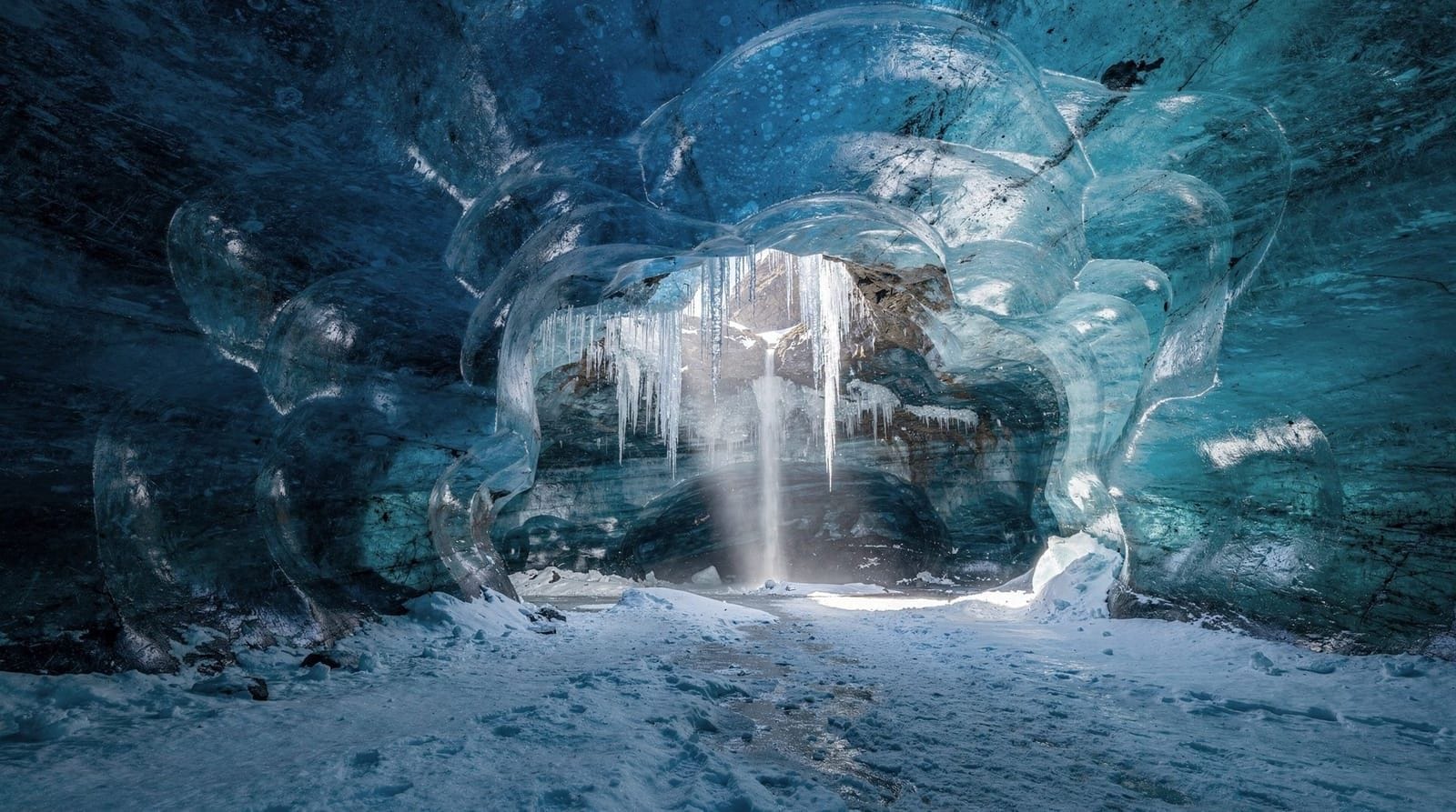
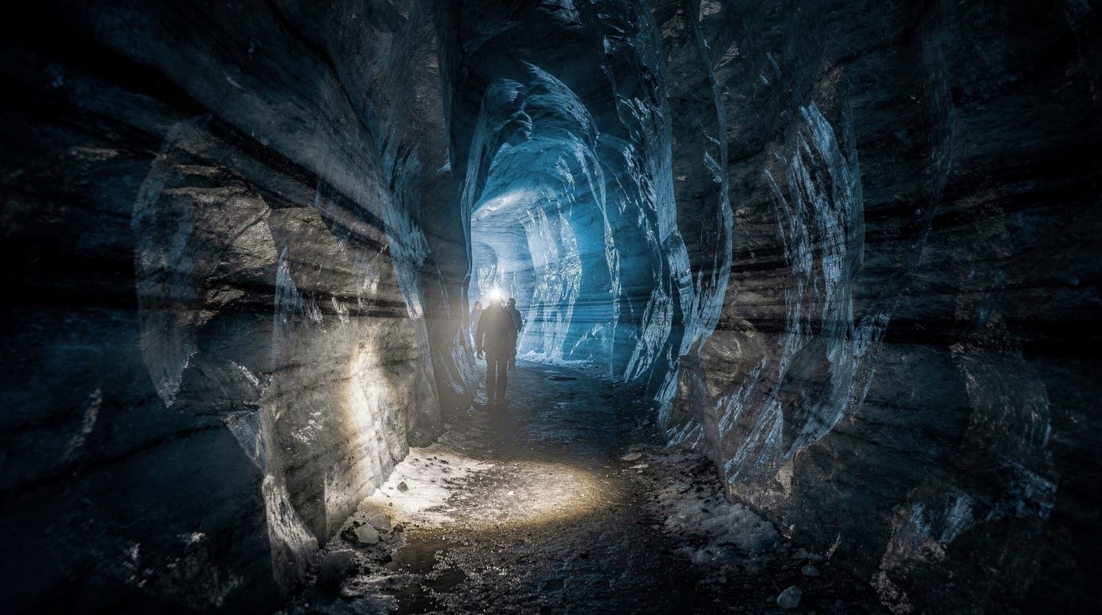
The glacier sits above Katla volcano, which last had a major eruption in 1918 and has been showing seismic activity periodically since. Directly beneath the glacier, Katla’s geothermal heat contributes to meltwater formation and has created a network of known sub-glacial cavities.
Tour operators run Katla ice cave tours that access ice caves formed within these sub-glacial cavities — an entirely different experience from surface glacier hiking, available year-round (unlike Vatnajökull ice caves, which are winter-only). The Katla ice cave entrance is near Vík, about 15 km east.
Combining a glacier hike at Sólheimajökull with a Katla ice cave tour in the same day is logistically possible but makes for a long day. Most visitors choose one or the other unless they have a full south coast day available.
The ice climbing introduction option
Several operators offer a variant of the Sólheimajökull hike that includes an ice climbing introduction — typically an extra 45–90 minutes on top of the standard glacier walk. This involves:
- A short section of near-vertical ice face used as a practice wall
- Basic instruction in front-pointing crampon technique (using the front points of crampons to kick into vertical ice)
- Use of a single or pair of ice axes for balance and security
- Guided climb of 3–5 metres of vertical ice (short but technically different from flat walking)
Most participants find this section the highlight of the trip. It’s genuinely satisfying to climb even a short ice wall using ice tools — the technique is different from rock climbing or any other movement sport, and the feedback from front-points gripping into ice is immediately rewarding.
The ice climbing intro doesn’t require any climbing background. The practice wall is typically less than 5 metres high and is top-roped (rope from above by the guide). Physical requirement is the ability to kick firmly into ice and hold body weight briefly on the front points — manageable for most adults with reasonable leg strength.
Price premium over standard glacier hike: roughly 3,000–5,000 ISK (€20–€33) per person.
Photography at Sólheimajökull
The glacier is heavily photographed and certain angles have become almost canonical on Iceland travel Instagram. That doesn’t diminish the real photographic opportunity — the landscape is genuinely striking, and a good photo here reflects real conditions, not artificial staging.
Best light: Winter and early morning/late afternoon in summer give the most atmospheric conditions. Overcast light reduces harsh shadows in ice crevasses and is often better for even exposure across dark ash and bright ice.
What to bring: A mid-range zoom (24–70mm or equivalent) covers most situations. A wide-angle (16–24mm) captures the scale of the glacier and the surrounding landscape. Protect your gear from glacial meltwater, which is everywhere.
What to avoid: Don’t step off the guided path for a better angle. This is frequently the reason people get into trouble at glacier termini. Take photos from the positions your guide indicates are safe.
The retreat lagoon: The small lagoon at the glacier terminus with its floating bergy bits is among the most photographed features. Early morning (before buses arrive) gives you the clearest shots without other tourists.
Sólheimajökull retreat — understanding what you’re seeing
The scale of glacial retreat at Sólheimajökull is visible without any geological training. The moraine ridges on either side of the current glacier terminus mark where the ice edge was in previous decades — some ridges from the 1930s–1950s are visible as clear raised berms several hundred metres up the valley walls.
The European Environment Agency and Icelandic Glaciological Society track Sólheimajökull specifically due to its accessibility and visibility. Measurements show the glacier retreating at roughly 30–100 metres per year in recent decades, varying with annual temperature and precipitation patterns. The meltwater lagoon that now exists at the terminus formed around the early 1980s.
For visitors, this context isn’t designed to depress — it’s to emphasise that what you’re seeing is a real-time geological process, not a static landscape. The glacier looks different every year. The photographs from your visit will show a Sólheimajökull that won’t exist in exactly the same form in another 10 years.
Safety realities
The barriers around Sólheimajökull exist for documented reasons. At least several serious incidents per year occur when tourists ignore restrictions and walk onto the unguided glacier terminus. The surface looks solid but crevasses at the lower glacier are obscured by snow bridges that collapse without warning.
Your guide’s pace and route selection are based on that morning’s conditions — not the conditions from last week’s Instagram posts. Follow instructions precisely, particularly around meltwater channels that can change drainage patterns rapidly.
Hypothermia risk is real at higher elevations even in summer. Bring extra layers even if the car park feels warm. Wind chill on exposed ice surfaces routinely pushes the effective temperature 8–12°C below the ambient reading.
The south coast context — Sólheimajökull in a day
Sólheimajökull doesn’t stand alone — it’s one of several exceptional stops along the south coast, and understanding its position helps with itinerary planning:
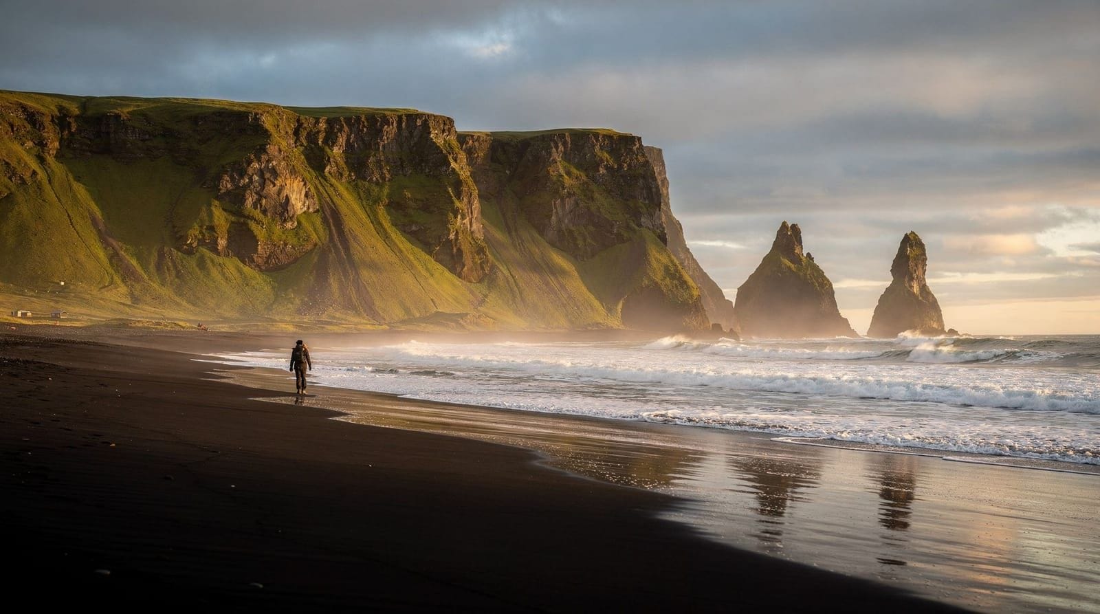
The south coast sequence: From Reykjavík east, the main stops are Seljalandsfoss (waterfall with walkable path behind), Skógafoss (60-metre waterfall at the base of a hiking trail), Sólheimajökull (the glacier, Route 222 south), Reynisfjara black sand beach, and Vík town. This sequence covers roughly 190 km from Reykjavík and is achievable in a single long day by car.
Where the glacier fits: Sólheimajökull’s access road (Route 222) branches south off Route 1 between Skógafoss and Reynisfjara. The detour from Route 1 to the car park takes 10 minutes. A 2.5-hour glacier hike means about 3.5 hours committed to the glacier from parking to departure.
How much of the south coast fits in a day: A full south coast loop including glacier hike from Reykjavík is genuinely possible in 12–13 hours (7:00 departure, 20:00 return). It’s long but the distances are manageable. Groups that want to linger anywhere — or add Dyrhólaey or a Katla ice cave — benefit from an overnight in Vík.
The honest trade-off: Organised south coast bus tours cover all the above stops but typically allow 30–45 minutes at each location. The glacier hike component on these tours is the most logistically constrained part — you’re usually looking at a 2-hour hike rather than a longer option. If the glacier is your main interest, driving independently and booking directly at Sólheimajökull gives you full control over timing.
Winter glacier hiking at Sólheimajökull
Sólheimajökull in winter (November–March) offers a different experience from the summer tours:
Daylight constraints: In December, Reykjavík gets about 4.5 hours of daylight. The drive to the glacier takes 2 hours each way. This means a winter glacier hike requires careful scheduling — operators typically run tours at 10:00 and 12:00 in mid-winter, giving participants usable light for a 2-hour walk.
Winter conditions: The glacier surface in winter is generally cleaner-looking than summer — reduced surface melt means less dirt and debris on the ice. The volcanic ash layers are more visible against white snow. Conditions can be significantly colder than summer; windchill at -15°C is possible in winter storms.
Aurora potential: Guides at Sólheimajökull sometimes run combined glacier hike + northern lights evening tours — a morning or afternoon glacier walk followed by darkness and aurora hunting on the south coast. The combination works logistically (though requires a second operator for the northern lights component or a guide agency running both activities).
Access reliability: Route 222 to the glacier car park remains accessible year-round in most winters. It can be icy; conditions requiring snow tyres or chains are possible December–March.
Frequently asked questions about Sólheimajökull glacier hike
What’s the difference between Sólheimajökull and Skaftafell for hiking?
Sólheimajökull is closer to Reykjavík (2 hours vs. 5+ hours) and better suited for day trips. Skaftafell (Vatnajökull) offers longer, more technical hikes and a more dramatic mountain backdrop. Both are on the south coast but separated by about 200 km.
Can I photograph on the glacier?
Yes. Most guides build in photo stops at key features. A 24–70mm lens covers most situations well. Wide-angle is useful for the blue ice sections. Protect your camera from glacial meltwater — it’s everywhere and it’s cold.
Is there parking at the glacier?
Yes — a large free car park on Route 222. No fee as of 2026. Facilities include toilets but no café.
What if Katla erupts while I’m on the glacier?
Seismic monitoring of Katla is continuous, and evacuation alerts are issued well before any imminent activity. Guided operators monitor alerts in real time and would not take groups onto the glacier during elevated alert status. The area has practiced and functional emergency response procedures.
Can I bring a dog?
No. Pets are not permitted on the glacier or in the immediate access area. Iceland’s biosecurity and conservation rules are strict about this.
Are the glacier hikes running in January?
Yes. Winter glacier hikes run at Sólheimajökull, though with shorter daylight (roughly 5–6 hours in December/January). Some operators run hike + northern lights combos in winter, which sounds glamorous but in practice means waiting for night conditions after the hike — sometimes worthwhile if aurora forecasts are strong.
Frequently asked questions about Sólheimajökull glacier hike
How long is the walk from the car park to Sólheimajökull glacier?
About 15 minutes on a flat gravel path from the car park to the glacier terminus. The path is well-marked and accessible. You'll fit crampons at the glacier edge, not the car park.Can I visit Sólheimajökull without a guided hike?
You can walk to the glacier terminus and take photos without a guide. The viewpoint is free to access. However, stepping onto the ice requires a guide — barriers and signs make this clear, and it's enforced by operators on-site.What operators run hikes at Sólheimajökull?
Several licensed operators run hikes here including Arctus, Tröll Expeditions, and Arctic Adventures. Prices are broadly similar (8,000–12,000 ISK / €55–€80 for a 2–3 hour walk). Comparing group sizes and guide certification is more important than price differences.Is Sólheimajökull safe to hike?
With a certified guide, yes. The glacier has significant crevasse fields and meltwater features that make independent walking extremely dangerous. Follow your guide's instructions and stay on the marked route.What does the ice look like at Sólheimajökull?
The ice is grey-black at lower elevations due to volcanic ash — Katla volcano sits directly beneath Mýrdalsjökull, of which Sólheimajökull is an outlet. Higher up, the ice transitions to cleaner blue-white. The ash layers are genuinely fascinating — each dark band represents a historical Katla eruption.Has Sólheimajökull retreated recently?
Yes, significantly. The glacier has retreated over 1 km in the past few decades. Photos from 20 years ago show the ice reaching much further into the valley. The lagoon at the terminus formed only as a result of this retreat. The retreat is visible year-on-year.
Top experiences
Bookable activities with verified prices and instant confirmation on GetYourGuide.

Top experiences
Best-rated activities across GetYourGuide and Viator.

Ice Cave by Katla Volcano Super Jeep Tour from Vik
- Viator

Sólheimajökull Glacier Hike – Adventure in a Small Group
- Viator

Ice Cave Tour from Vík
- Viator

Blue Ice Discovery – Guided Glacier Hike from Skaftafell
- Viator

Glacier Hike from Skaftafell - Extra Small Group
- Viator

East Glacial River – Grade 4 Rafting with Drysuits, North Iceland
- Viator