Skógafoss to Fimmvörðuháls — what the first day actually looks like
The waterfall you start from
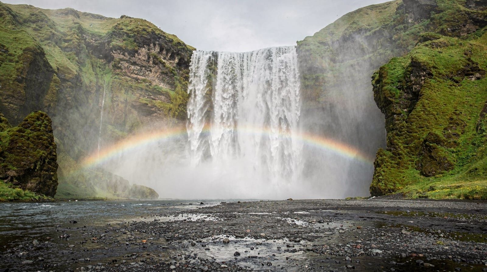
Every description of the Fimmvörðuháls hike starts with Skógafoss, and every description is right to do so. The falls drop 60 metres and you can walk behind the curtain of water on a path cut into the cliff face. In July, the spray is constant and cold and you will be wet within two minutes if you walk too close. The crowd at the base of the falls is large in mid-summer; the trail up the eastern side, which begins the Fimmvörðuháls route, is busy until about 11 a.m. and then thins as the day hikers turn back.
The eastern staircase next to Skógafoss itself is steep — maybe 400 steps — and brings you to the top of the cliff where the Skógá river spreads out upstream. From the top of the falls, the path follows the river east and south into the highland plateau. This transition — from the dramatic tourist spectacle at the base to the quiet, wide highland river valley — happens within 20 minutes and feels like stepping into a different Iceland entirely.
We arrived at Skógafoss at 7:30 a.m., which was exactly right. The light was horizontal from the east. The falls were backlit and golden. There were perhaps 20 other people at the base. By 9 a.m., the car park was filling; by 10 a.m., the path up the staircase would have a queue. Starting early is not optional on this route in summer.
The valley of waterfalls
The first 8-10 kilometres of the Fimmvörðuháls hike follow the Skógá river through what is sometimes called the valley of waterfalls — more than 20 named waterfalls between Skógafoss and the highland plateau. Most are unnamed on trail maps and visible from the path without any detour. Some are impressive cascades in their own right; taken as a sequence they create a persistent soundtrack of water that follows you for hours.
The trail is well-marked but increasingly rough above the first major plateau. You gain about 900 metres of elevation between the base of Skógafoss and the Fimmvörðuháls pass at around 1,000 metres. In the middle section, the path crosses fields of wet moss and some areas of boulder hopping. Trekking poles are useful from about the halfway point.
The quality of the waterfall valley depends significantly on the day before and the week before — spring snowmelt in June can make the crossings thigh-deep, while a dry July can make the same crossings ankle-deep. We had moderate conditions in July: the river was fast and clear, the crossings were knee to thigh depth at the widest points, and we crossed in gaiters without problems.
We left Skógafoss at 8 a.m. and reached the hut at Baldvinsskáli — the first overnight stop, roughly 12 kilometres in — at about 1:30 p.m., including a 30-minute break at a waterfall named Kattahamrar (unofficial name from local hikers) that I still think about. Time taken: 5.5 hours moving, 5.5 hours total including breaks.
Gear that earned its weight
A brief note on what made a difference. Waterproof gaiters were essential — not just for river crossings but for the wet moss sections, which soak ordinary boot uppers within 20 minutes. We had Berghaus Yeti gaiters and they kept boots dry through the entire valley section.
Trekking poles helped on the boulder sections above the valley and were invaluable on the descent. The descent from the pass back to Skógafoss (if you are doing it as a there-and-back rather than continuing to Þórsmörk) involves the same 900 metres of elevation in the other direction and poles significantly reduce the knee impact.
Layers were important in the counter-intuitive way that Iceland always demands: we started cold and stripped to a single base layer in the valley during a warm mid-morning stretch, then added every layer we had at the pass. The temperature difference between valley floor (around 14°C in July) and pass (around 4°C in the same July afternoon) was striking.
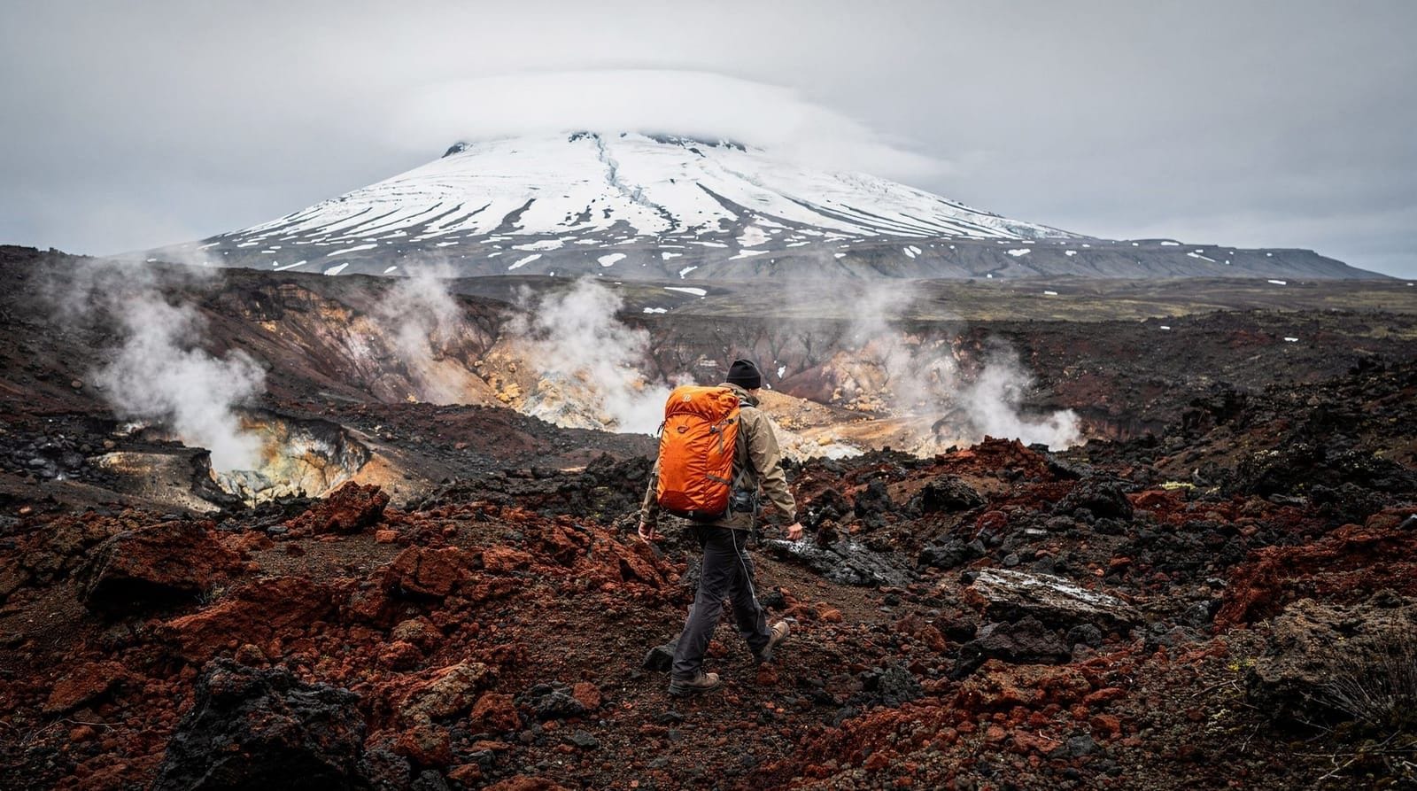
The volcanic craters: what nobody mentions
Above the valley section, the trail passes through the most recent volcanic terrain in Iceland: the craters Magni and Móði, formed during the 2010 Eyjafjallajökull eruption. These are two new craters in raw, dark lava — a landscape only 13 years old at the time of our walk. The lava fields have the specific appearance of young volcanic rock: jet black, lightly weathered on the surfaces but unchanged in form, with no vegetation yet established.
Walking through this section is strange and affecting. The lava is rough underfoot and the trail is marked by cairns and coloured ropes rather than a worn path, because no significant path has yet been established on the young rock. The contrast with the ancient glaciated highlands just ahead is jarring in an instructive way — here is Iceland making its geology explicit, the old buried under the new.
The craters themselves can be circled on a short detour from the main trail. The interior of Magni crater in July held a snowfield at the bottom; the dark walls rising from white ice had an almost cinematic quality. The smell of sulphur is faint here — this area is technically still geothermally active — but not unpleasant.
On a clear day, views from this section extend south to the coast and north toward the Mýrdalsjökull ice cap. We had partial cloud, which created an intermittent dramatic light and hid the crater walls entirely for ten-minute stretches.
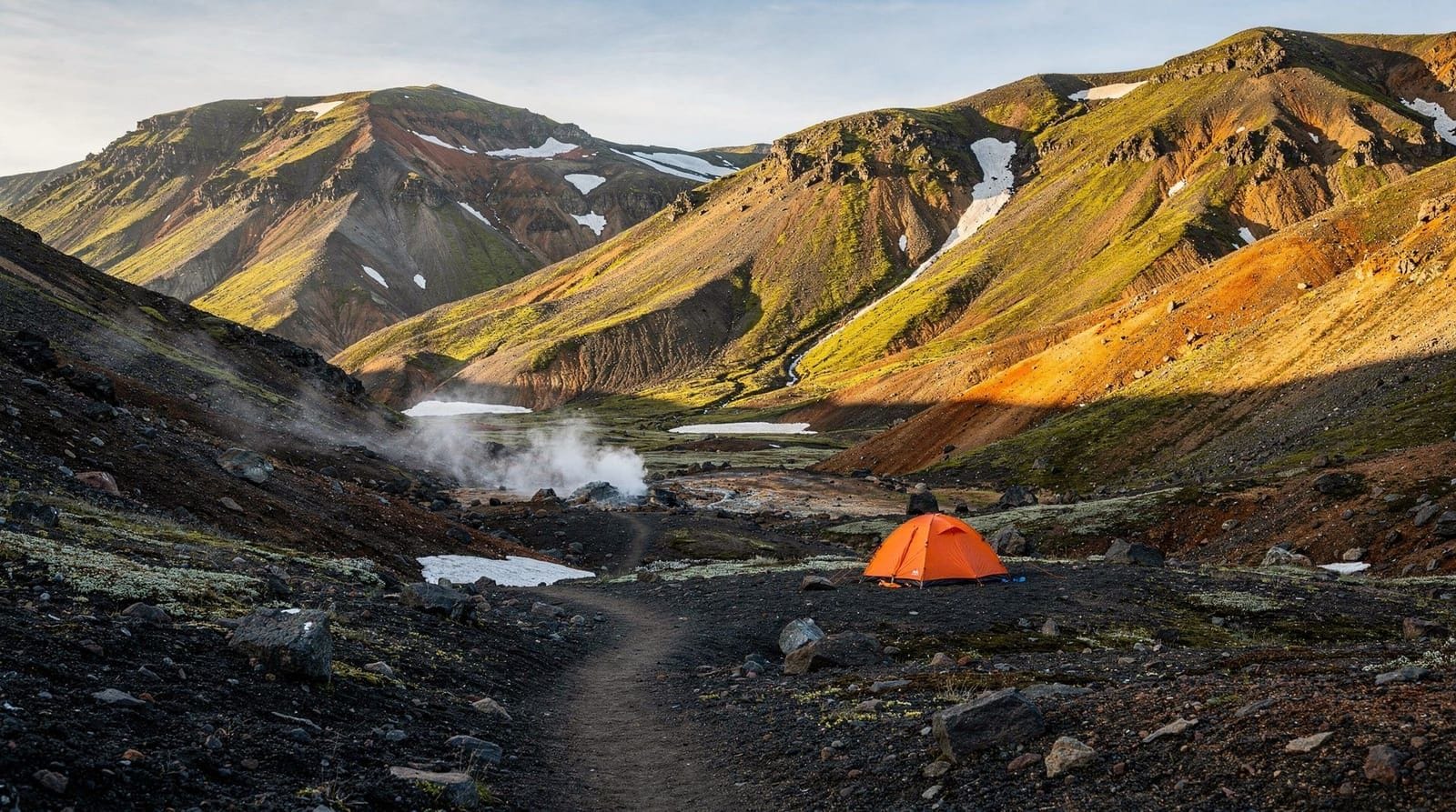
The pass and what you find there
Fimmvörðuháls pass is between two glaciers: Eyjafjallajökull to the west and Mýrdalsjökull to the east. In July, the glaciers are still present but their edges recede visibly from year to year. The view from the pass is one of the more desolate and beautiful in Iceland: black lava, white ice, no vegetation, a sky that in good weather is an extraordinary deep blue at altitude.
Baldvinsskáli hut at the pass is a Ferðafélag Íslands (Iceland Touring Association) mountain hut with sleeping-bag accommodation. You must book in advance — this cannot be overstated. The hut fills months ahead for July. Sleeping capacity is around 25 in the main hut plus an overflow annex. The warden cooks dinner (simple but adequate: pasta, lamb stew on our visit) and there is a gas stove for making tea. The toilet is an outhouse. Bring earplugs: mountain huts have enthusiastic snorers.
The hut booking opens in January for the following summer season. Log into the Ferðafélag Íslands website and book as soon as it opens if you want a specific date in July. August is slightly easier to book but still fills quickly.
From the pass, many hikers continue south toward Thorsmörk and the Laugavegur trek — a further 23 kilometres to the Þórsmörk valley. This is a serious multi-day commitment. Day hikers who walked up from Skógafoss return the same way; the views on the descent are completely different from the ascent and the journey back still takes 4-5 hours.
Connecting to the south coast
The Fimmvörðuháls trailhead at Skógafoss sits at one of the most accessible stretches of the Icelandic south coast. Seljalandsfoss is 30 kilometres west along Route 1 — the waterfall you can walk behind, whose car park fee is around 700 ISK. Reynisfjara black sand beach and the rock stacks at Vík are 30 kilometres east. If you are approaching from Reykjavík on the south coast day trip route, Skógafoss is a natural anchor point.
The hiking trail connects the south coast to the Þórsmörk hiking area at the northern end of the Fimmvörðuháls pass — which is itself the southern terminus of the Laugavegur. Arriving by foot from Skógafoss to Þórsmörk and then walking the Laugavegur to Landmannalaugar is the classic multi-day traverse of Iceland’s southern highlands. The Laugavegur trek guide covers the logistics.
If you want to experience the south coast including Skógafoss, Reynisfjara, and Seljalandsfoss in one organised day before committing to the Fimmvörðuháls hike, the South Coast full-day tour from Reykjavík is a good orientation trip.
Practical information
The Fimmvörðuháls hike guide has the complete logistics — trail conditions by month, hut booking links, what gear to carry. A few additions from experience:
Weather on the pass is highly variable and changes fast. I wore a t-shirt in the valley and a down jacket and waterproof at the pass within four hours. Always carry full waterproof layers and an insulating layer, regardless of the morning forecast. The Met Office (vedur.is) mountain forecast is the right source — not the general Reykjavík forecast, which will tell you nothing about pass conditions.
The trail starts at Skógafoss, not at the parking area 2 kilometres east of the falls. The parking area has toilets and a small cafe (soup, pastries, coffee). The parking is free. The car is safe overnight in the parking area; we left ours for the two nights we were at the pass.
Water from the Skógá river and its tributaries is drinkable without treatment below the glaciers; apply judgment above the glacier margins. Bring a filter if you are uncertain.
Whether it is worth it
The Fimmvörðuháls hike is more demanding and less celebrated than the Laugavegur, which it connects to on the north end. This means it is also less crowded than Laugavegur in peak season, more varied in a single day (waterfalls, active volcanic landscape, glaciers in sequence), and more accessible for people without multi-day trekking logistics.
Day one from Skógafoss to Baldvinsskáli is a full day by any standard — 12-14 kilometres, 900 metres ascent, varied terrain. It is not technical, but it is not a stroll either. Come fit, come prepared for weather, and book the hut early.
It is, genuinely, one of the best single hiking days I have had in Iceland.