Iceland canyons guide — the best gorges and ravines to explore
Eastern Region Iceland: From Seydisfjordur studlagil canyon private tour
What is the most impressive canyon in Iceland?
Jökulsárgljúfur in north Iceland (the canyon containing Dettifoss) is the most dramatic by scale — 25 km long, 100 m deep. Fjaðrárgljúfur on the south coast is the most photographed and easiest to access. Stuðlagil basalt column canyon is the most visually unique.
Iceland’s canyons are a geological argument for paying attention. The same volcanic forces that create lava fields and glaciers also produce dramatic geological scars — river gorges cut through lava fields, glacial flood channels carved into the highland plateau, and basalt columns eroded by water into gallery formations. Each canyon tells a different chapter of Iceland’s geological history.
This guide covers the six most worthwhile canyon experiences in Iceland, ranging from easy roadside viewpoints to multi-day highland expeditions.
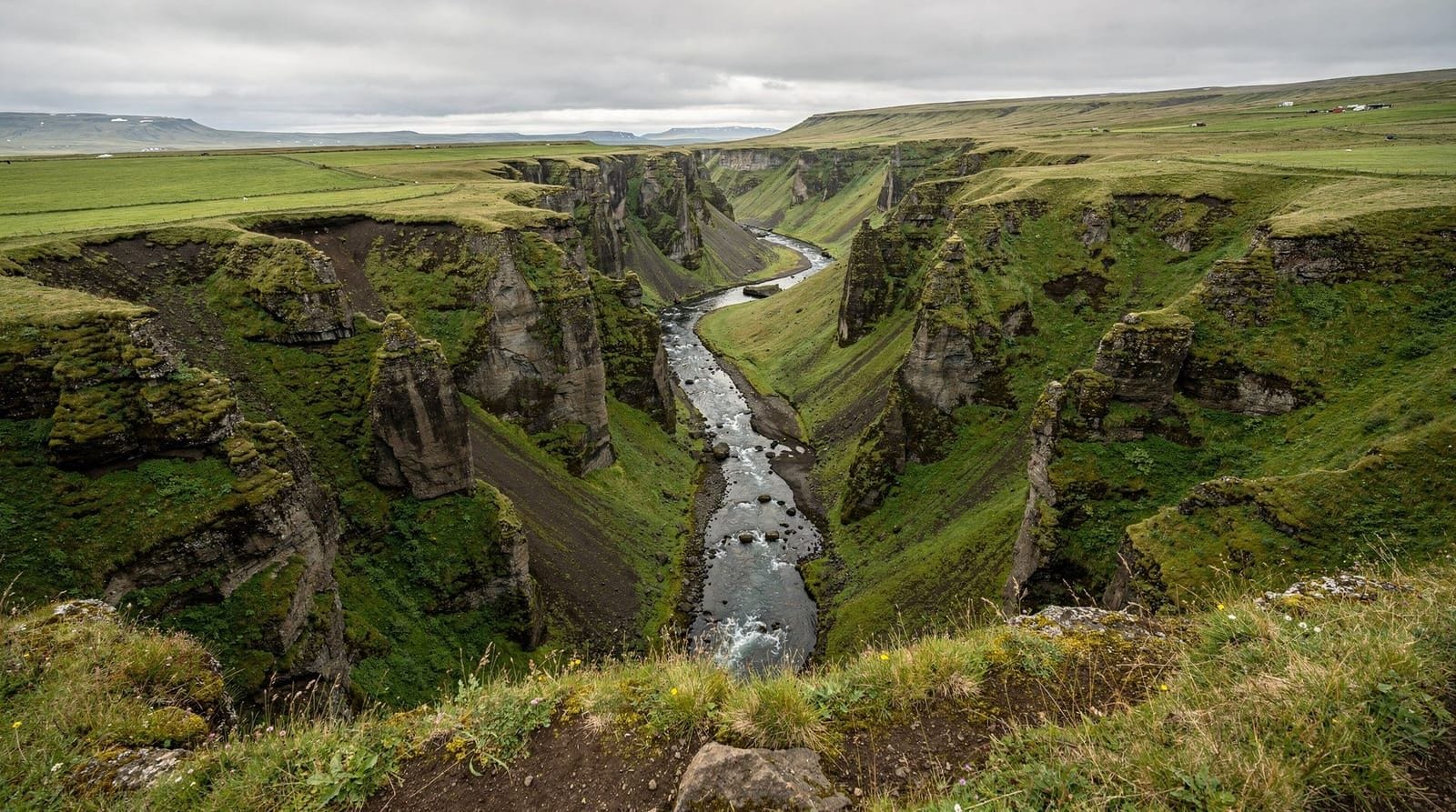
Fjaðrárgljúfur — Iceland’s most photographed gorge
Fjaðrárgljúfur is on the south coast, 8 km north of Kirkjubæjarklaustur off Route 1. The canyon is approximately 100 m deep and 2 km long, cut into old lava by the Fjaðrá river over millions of years. The result is a sinuous, narrow gorge with curving walls that photograph spectacularly from the rim trail above.
The canyon became globally famous when Justin Bieber filmed a music video here in 2015. This had the effect of bringing enormous tourist numbers to what was previously a quiet local landmark, prompting temporary closures for path restoration (2019). The trail has since been rehabilitated and is open.
Access: From Route 1, turn north onto Route F206 (paved for the first section, passable in a standard car for 8 km to the canyon). Large car park at the trailhead. Free.
Trail: A maintained path follows the east rim of the canyon for approximately 1.5 km to the highest viewpoint. The views looking down into the canyon and along its curving length are exceptional. Allow 1–1.5 hours return.
Photography: Best with a standard zoom (35–70 mm) looking along the canyon axis from the rim viewpoints. Wide angle loses the sense of depth. Overcast days are better than bright sun for even lighting in the deep gorge.
Tours combining Jökulsárlón glacier lagoon with Fjaðrárgljúfur canyon cover two of the most distinctive geological sites in the same stretch of south Iceland. The canyon adds 2–3 hours to a glacier lagoon day and is adjacent enough to combine naturally.
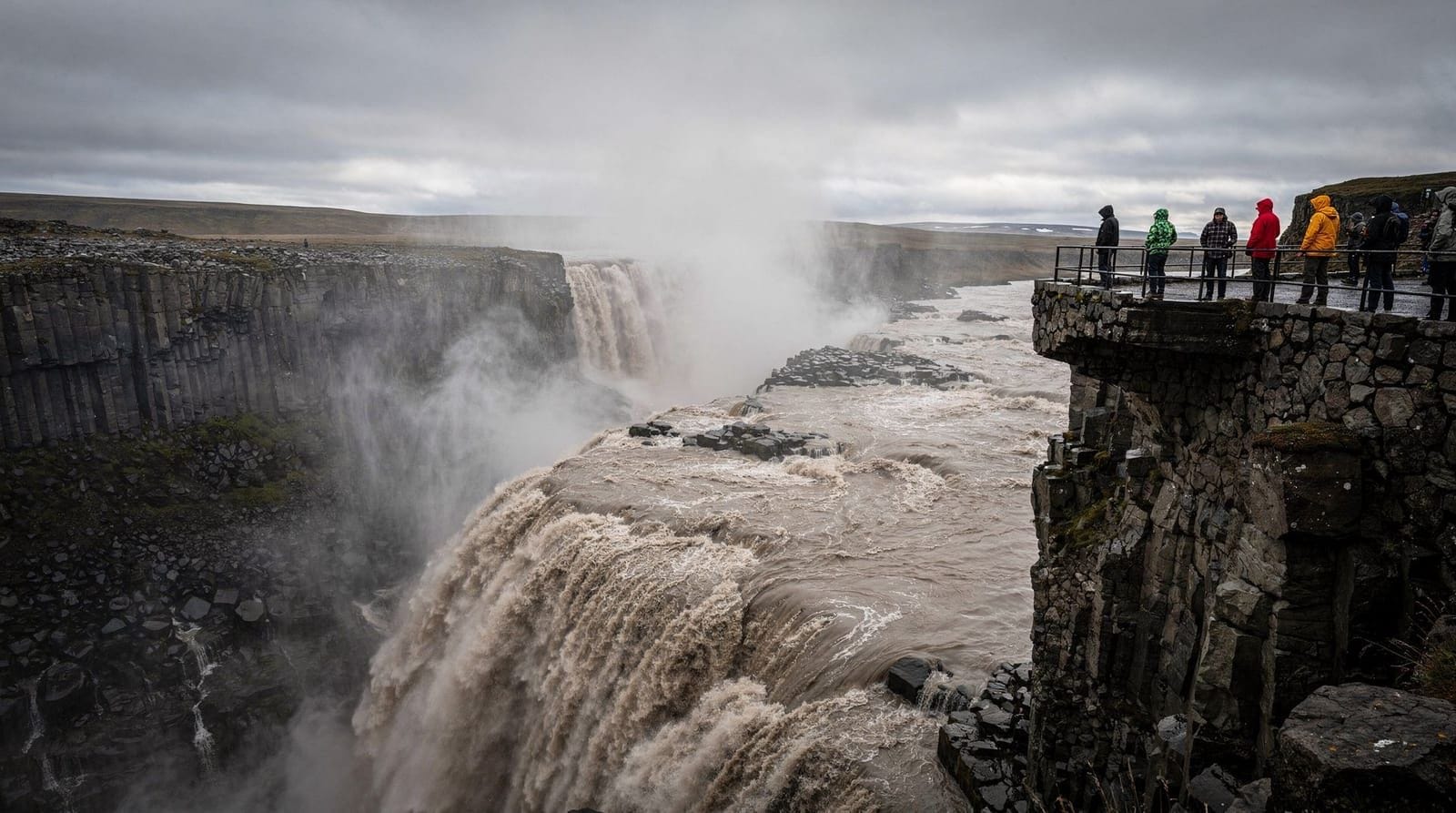
Jökulsárgljúfur — the Dettifoss canyon
The most dramatic canyon in Iceland by scale is the one you stand at the edge of when visiting Dettifoss. Jökulsárgljúfur (the canyon of the Jökulsá á Fjöllum river) extends 25 km north from Dettifoss through Vatnajökull National Park, reaching depths of 100 m and widths of 500 m in places.
The canyon was carved by catastrophic glacial floods — jökulhlaup events — following subglacial volcanic eruptions in the past 10,000 years. In the largest events, water flow exceeded 200,000 m³/s — more than the current combined flow of all the world’s rivers. The result is a canyon that looks ancient but is geologically young.
Exploring the canyon: A multi-day hiking trail (approximately 35 km) follows the canyon from Dettifoss north to Ásbyrgi. Most visitors see only the section near Dettifoss (viewpoints at Dettifoss, Selfoss, and Hafragilsfoss). The Ásbyrgi end of the canyon has a separate character — the horseshoe-shaped depression was formed by a single catastrophic flood event and is now heavily vegetated, creating an enclosed woodland canyon.
Stuðlagil — the basalt column canyon
Stuðlagil is in east Iceland, near Jökuldalur valley, approximately 50 km north of Egilsstaðir. It is arguably the most visually striking canyon in Iceland and one of the least visited. The canyon walls are lined with closely-packed hexagonal basalt columns — hundreds of perfect geometric pillars flanking both sides of the turquoise Jökulsá á Dal river.
The combination of geometric stone columns and brilliantly coloured river (the turquoise comes from glacial meltwater) is extraordinary. The canyon was only accessible to its full extent after a dam upstream reduced water flow in 2009, revealing canyon sections that were previously submerged.
Access: From Egilsstaðir, drive north and west on Routes 1 and 923 to Klaustursel farm, then hike approximately 6 km along the east bank to reach the most dramatic section. The hike is on rough terrain. On the west bank, shorter access from a different trailhead reaches a different but impressive section. Allow a full day.
Stuðlagil is remote enough that a guided tour from Seyðisfjörður or Egilsstaðir significantly reduces navigation complexity. Private tours allow you to pace the canyon walk according to your own interest rather than a fixed group schedule.
Eldgjá — the volcanic canyon with a waterfall
Eldgjá (“Fire Canyon”) is a 270 km² volcanic canyon system in the southern highlands, formed by the catastrophic 934 CE eruption — one of the largest volcanic eruptions in recorded history worldwide. The fissure opened for 75 km through the plateau, creating a canyon up to 270 m deep and 600 m wide.
Within Eldgjá, the Ófærufoss waterfall drops 40 m into the canyon. A natural basalt arch once spanned the falls but collapsed in the 1990s; the falls are still dramatic without it.
Access: Strictly 4WD only, via highland road F233. Open approximately July–early September depending on snow conditions. From Kirkjubæjarklaustur, the drive takes approximately 2.5–3 hours one way on F-roads. This is highland territory — prepare accordingly. See the F-roads Iceland guide.
Ásbyrgi — the horseshoe canyon
Ásbyrgi is technically not a river gorge but a glacial flood canyon — a 3.5 km long, 1 km wide horseshoe-shaped depression with 100 m tall walls, formed by a single jökulhlaup event thousands of years ago. Norse mythology described it as the hoofprint of Odin’s eight-legged horse Sleipnir.
The floor of the canyon is now heavily forested by Icelandic standards (birch, dwarf birch, willow) and contains a small lake. A campsite operates in the canyon floor, surrounded by the towering walls. The combination of forest, lake, and sheer basalt walls is a completely different aesthetic from Jökulsárgljúfur.
Access: Off Route 85 in north Iceland, 60 km north of Dettifoss. Well-maintained road, suitable for 2WD in summer. Free.
Rauðfeldsgjá — the Snæfellsnes gorge
Rauðfeldsgjá is a narrow gorge on the Snæfellsnes Peninsula, formed by a geological fault in the Snæfellsjökull volcano’s flanks. The gorge is approximately 30 m deep and only 2–3 m wide in places — you enter by walking up a stream that runs through the bottom.
Access: Off Route 54, near the village of Arnarstapi. Walk up the stream into the gorge — requires waterproof footwear. The gorge extends approximately 200 m before becoming too narrow to continue. Short (30 minutes) but memorable.
Canyon safety
Icelandic canyon rim trails typically have no barriers. The rim of Fjaðrárgljúfur is directly accessible to the edge. The Jökulsárgljúfur canyon wall near Dettifoss has had partial collapses in recent years.
General rules:
- Stay on marked paths
- Do not approach canyon edges on loose gravel or wet grass
- In wind, edges become especially hazardous — wind gusts in exposed areas can be unexpected
- The canyon walls around Dettifoss are specifically unstable — sections have fallen into the gorge
Frequently asked questions about Iceland’s canyons
Can I hike inside Fjaðrárgljúfur canyon?
No — access is restricted to the rim trail only. Descending into the gorge is not permitted; the vegetation and path structure inside the canyon is fragile and restricted for conservation reasons.
Is Stuðlagil worth the long drive from Reykjavík?
Only if you’re already doing east Iceland or the Ring Road. As a standalone trip from Reykjavík, it requires 5+ hours of driving each way. If you’re driving the Ring Road east, it’s an excellent half-day detour from Egilsstaðir.
Can I do Eldgjá without a 4WD?
No. The F-roads leading to Eldgjá require a proper 4WD. Attempting them in a 2WD risks getting stranded on a remote highland road. See the renting a car in Iceland guide and 2WD vs 4WD guide.
What is the best canyon to visit in a day from Reykjavík?
Fjaðrárgljúfur (165 km from Reykjavík on the south coast) is the most accessible. It pairs naturally with south coast attractions. The full south coast loop including Fjaðrárgljúfur is approximately 500 km but very manageable in a long summer day.
When are the highland canyons accessible?
Eldgjá and other highland canyon systems are typically accessible from late June to early September, depending on the year’s snowfall. The F-roads that access them open when snow levels allow — check vegagerdin.is (Icelandic Road Administration) for current highland road status.
The geology of Icelandic canyons
Iceland’s canyons fall into three distinct formation types, each telling a different geological story:
River erosion canyons (Fjaðrárgljúfur type): Formed over millions of years by river downcutting through relatively soft basalt and palagonite tuff. These canyons are characterised by curved, organic shapes as the river meanders while cutting deeper. The meanders create the distinctive S-curves visible from Fjaðrárgljúfur’s rim viewpoints.
Glacial flood canyons (Jökulsárgljúfur type): Cut catastrophically by jökulhlaup events — ice-age glacial outburst floods carrying millions of cubic metres of water per second. These canyons are characterised by steep, parallel walls, irregular giant potholes (kettles), and lack of the meandering quality of river-eroded canyons. They formed in days to weeks rather than millennia.
Volcanic rift canyons (Þingvellir type): Created by tectonic separation, where the crust literally pulls apart. The floor drops as the two sides move in opposite directions. The Þingvellir Almannagjá rift canyon is the most accessible example — you can walk between two continents here, with the canyon marking the boundary.
Eldgjá is a fourth type — a volcanic fissure canyon, where the canyon itself is the result of a massive eruption opening a crack in the earth.
Fjaðrárgljúfur and Justin Bieber — a practical note
The 2015 music video filmed at Fjaðrárgljúfur generated immediate global attention and contributed to visitor numbers increasing from a few thousand annually to hundreds of thousands. This created significant erosion on the unmarked slopes visitors were using to descend toward the canyon floor.
The Icelandic Environment Agency closed Fjaðrárgljúfur in 2019 for rehabilitation. The canyon reopened in 2020 with improved marked trails, wooden boardwalks in the most vulnerable sections, and a proper car park.
The current infrastructure is well-designed. The wooden boardwalk and gravel path along the east rim is approximately 1.5 km and gives access to five main viewpoints. The approach road (Route F206) is paved for the first 8 km to the car park and accessible in a standard 2WD.
What has not changed: descending into the canyon floor is still prohibited. The canyon vegetation (moss, arctic willow, and grasses on the canyon walls) remains vulnerable to trampling.
Stuðlagil — a case study in discovered landscapes
Stuðlagil was not hidden — local farmers and the Jökuldalur valley community knew it existed. What changed was accessibility. The Kárahnjúkavirkjun hydroelectric dam project (completed 2009) reduced water flow in the Jökulsá á Dal river significantly, revealing canyon sections that were previously submerged.
As photographs from the newly exposed canyon spread on social media (particularly after 2016–2017), international visitor numbers grew rapidly. The canyon went from an obscure local feature to an internationally recognised photography destination within a few years.
The lesson relevant to Iceland travel generally: the “undiscovered” sites are often simply underreported. Local knowledge frequently identifies natural features that mainstream tourism marketing hasn’t yet amplified. Asking local residents or guesthouse owners often yields better recommendations than travel guides.
Canyon photography — general principles
Each canyon type requires a different approach:
River meander canyons (Fjaðrárgljúfur): Look along the canyon axis, not across it. The best compositions show the full S-curve from an elevated position. Use a telephoto (100–200 mm) to compress the canyon turns.
Glacial flood canyons (Jökulsárgljúfur at Dettifoss): The scale is best conveyed with a human figure in the frame. Without scale reference, even a 100 m wide canyon looks modest in photographs. If you’re with someone, use them as a reference point.
Basalt column canyons (Stuðlagil): The columns are best photographed with a polarising filter to reduce water reflections and reveal the turquoise river colour. In summer, the low north Iceland sun angle creates challenging direct light — overcast days are significantly better.
Volcanic rift canyons (Ásbyrgi horseshoe): The scale is only apparent from the rim. Walk to the south end of Ásbyrgi and look north along the full 3.5 km length — the width and sheer walls only become apparent from this perspective.
Beyond the obvious — less-known Icelandic canyons
Gjáin valley (Þjórsárdalur area): A lava canyon in the southern highlands with multiple small waterfalls and bright green vegetation. Accessible via highland roads from Route 26. The contrast between the black lava canyon and the intense green moss makes it among Iceland’s most photogenic small sites.
Hvítserkur area (north Iceland): More a coastal rock feature than a canyon, but the 15 m high basalt stack rising from the sea north of Vatnsnes Peninsula is extraordinary and almost unknown internationally. See the north Iceland itinerary for context.
For the Ring Road traveller, the single best canyon-related detour is Fjaðrárgljúfur on the south coast — it’s 5 km off Route 1, takes 1.5 hours, and represents the river-canyon experience that nothing else on the main route provides.
Planning canyon visits by season
Summer (June–August): All canyons are accessible. Highland canyons (Eldgjá, Gjáin, Ófærufoss) open from approximately late June. Fjaðrárgljúfur, Jökulsárgljúfur, and Ásbyrgi are open year-round. Stuðlagil is best June–September when water levels are stable.
Shoulder season (May, September–October): Fjaðrárgljúfur and Ásbyrgi are excellent — fewer people, often better light. Highland canyons typically closed until late June. Stuðlagil in September is arguably the best photography month (low autumn light, basalt columns in relief).
Winter (November–April): Jökulsárgljúfur at Dettifoss has a winter dimension — snow on the canyon walls. Fjaðrárgljúfur can be icy and is best avoided in truly icy conditions. Ásbyrgi in winter is quiet and atmospheric. Highland canyons: inaccessible.
Canyon safety — the overlooked hazard
Unlike waterfall safety (where wave action is the primary risk) or glacier safety (where crevasses are the risk), canyon safety is primarily about edge instability and path clarity.
Fjaðrárgljúfur: The rim path has no barriers at the main viewpoints. The volcanic bedrock is competent but the edge vegetation (grass and moss growing over the basalt lip) can conceal where solid ground ends. In rain or frost, this edge becomes slippery. Stay 1–2 m back from visible edge vegetation.
Jökulsárgljúfur at Dettifoss: The canyon walls here are specifically known for instability. Basalt columns that appear solid have separated from the main cliff face and fallen into the gorge without warning. The official viewpoints are positioned at safe distance; going beyond them to get a better angle is genuinely dangerous.
Stuðlagil: The trail involves some boulder-hopping near the river and can be slippery on wet basalt. There is no formal trail for much of the route — navigation requires some skill and appropriate footwear.
Ásbyrgi: The enclosed nature of the horseshoe canyon makes weather assessment important. Flash flooding (very rare but possible in heavy rain) flows into the canyon. For camping, be aware of the canyon’s water drainage during rain events.
Combining canyons with other south Iceland attractions
Fjaðrárgljúfur (165 km from Reykjavík) pairs naturally with Jökulsárlón glacier lagoon (another 210 km east). The canyon is typically visited as a 1.5-hour detour 5 km off Route 1, then the drive continues east to the lagoon.
The complete south coast glaciers 4-days itinerary incorporates this combination in a structured format:
- Day 1: Seljalandsfoss, Skógafoss, Reynisfjara
- Day 2: Fjaðrárgljúfur canyon, Kirkjubæjarklaustur, Skaftafell
- Day 3: Jökulsárlón and Diamond Beach
- Day 4: Return west with additional stops
This is the most efficient format for seeing south Iceland’s best geological features including canyons, waterfalls, glaciers, and black sand beaches in a single trip. See the Iceland travel guide for the broader planning picture.
Top experiences
Bookable activities with verified prices and instant confirmation on GetYourGuide.

Top experiences
Best-rated activities across GetYourGuide and Viator.

Ice Cave by Katla Volcano Super Jeep Tour from Vik
- Viator

Puffin and Volcano Tour with Ebbi
- Viator

Dynjandi Waterfall & Farm Visit Tour from Isafjordur Port
- Viator

3,5-Hour Sightseeing Tour To Dynjandi Waterfall
- Viator

Volcano ATV Tour
- Viator

Lake Myvatn Day Tour and Godafoss Waterfall for Cruise Ships from Akureyri Port
- Viator