Snæfellsnes day trip from Reykjavík — the complete guide
Grundarfjörður: From Reykjavik full day Snaefellsnes peninsula
Duration: ~11 hours
Can you do Snæfellsnes as a day trip from Reykjavík?
Yes, but it is a long day — the driving alone is 360+ km and takes about 9 hours including stops. Depart by 07:30–08:00 for a comfortable circuit. The peninsula is Iceland's most scenically diverse compact region: glacier, lava coast, bird cliffs, seal beach, fishing villages, and Kirkjufell all within the same 90 km peninsula.
The Snæfellsnes Peninsula extends 90 km westward into the North Atlantic from the main body of Iceland, capped by the Snæfellsjökull glacier-volcano that Jules Verne chose as the fictional entrance to the centre of the Earth. It is the most compact concentration of landscape diversity in Iceland — glacier, lava coast, seal beach, bird cliffs, fishing villages, and the photogenic Kirkjufell mountain all within a manageable peninsula circuit.
Unlike the Golden Circle, which follows a mostly inland route, Snæfellsnes is a coastal drive throughout. The views across Breiðafjörður bay toward the Westfjords, the lava coastline at Arnarstapi, and the constant presence of the glacier give the route a visual quality distinct from anything on the South Coast or Golden Circle.
The main stops in order (south shore approach)
Most visitors approaching from Reykjavík take the south shore first (via Borgarnes and Route 54 toward Snæfellsjökull), circuit the tip of the peninsula, and return via the north shore through Grundarfjörður and Kirkjufell. Here is what to expect at the key stops:
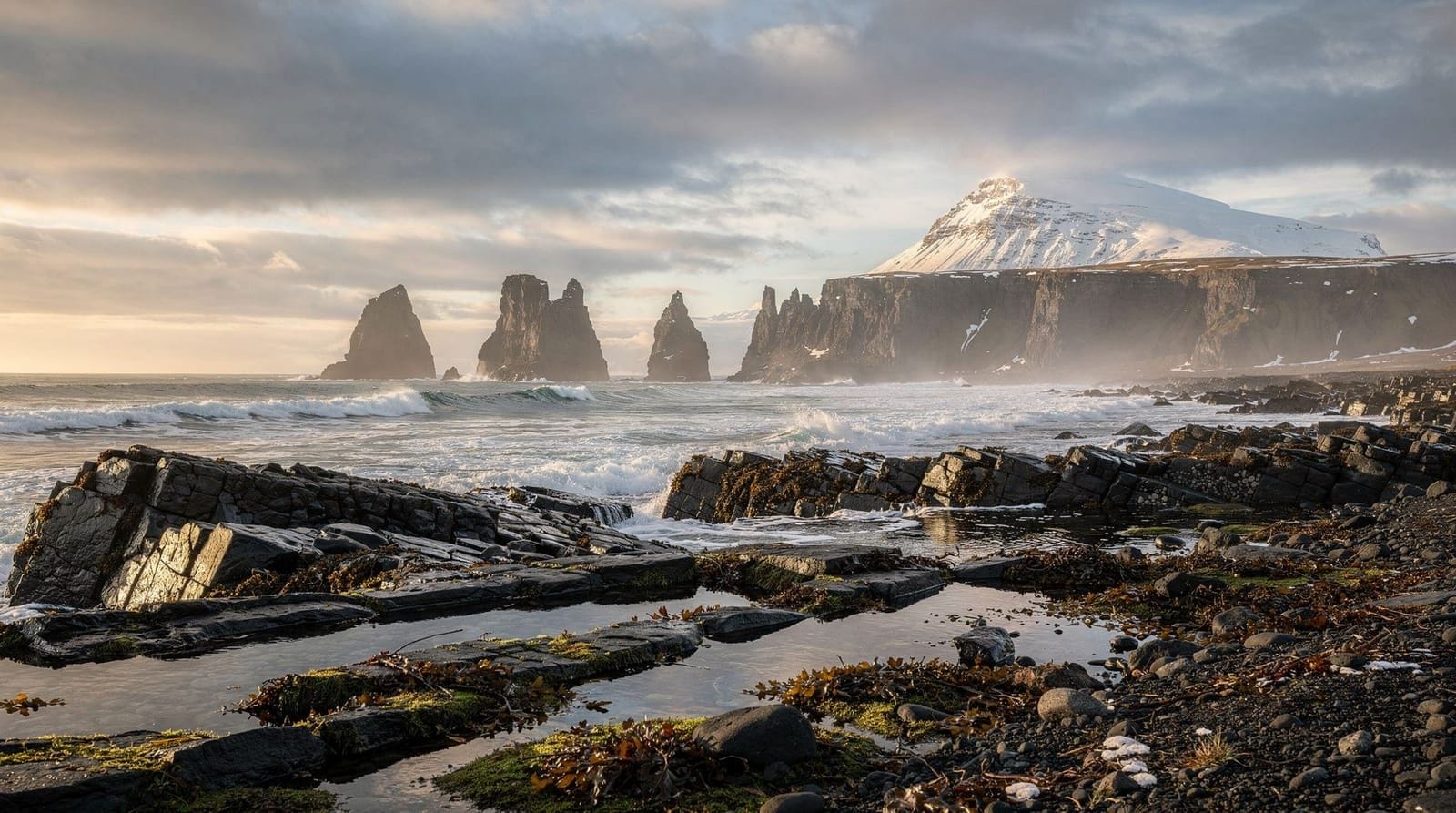
Arnarstapi and Hellnar
The coastline between Arnarstapi and Hellnar on the south shore is a 2.5 km coastal path through lava formations, sea arches, and rock stacks. The walk is genuinely spectacular — Arctic terns, kittiwakes, and fulmars nest on the cliffs, and puffins appear in summer.
Arnarstapi village has a striking basalt arch and a seafood café (Snjófell, good fish soup and fresh langoustines at fair prices). The stone sculpture of Bárður Snæfellsás (a figure from Icelandic legend connected to the glacier) stands at the harbour.
Allow: 1.5–2 hours including the coastal walk.
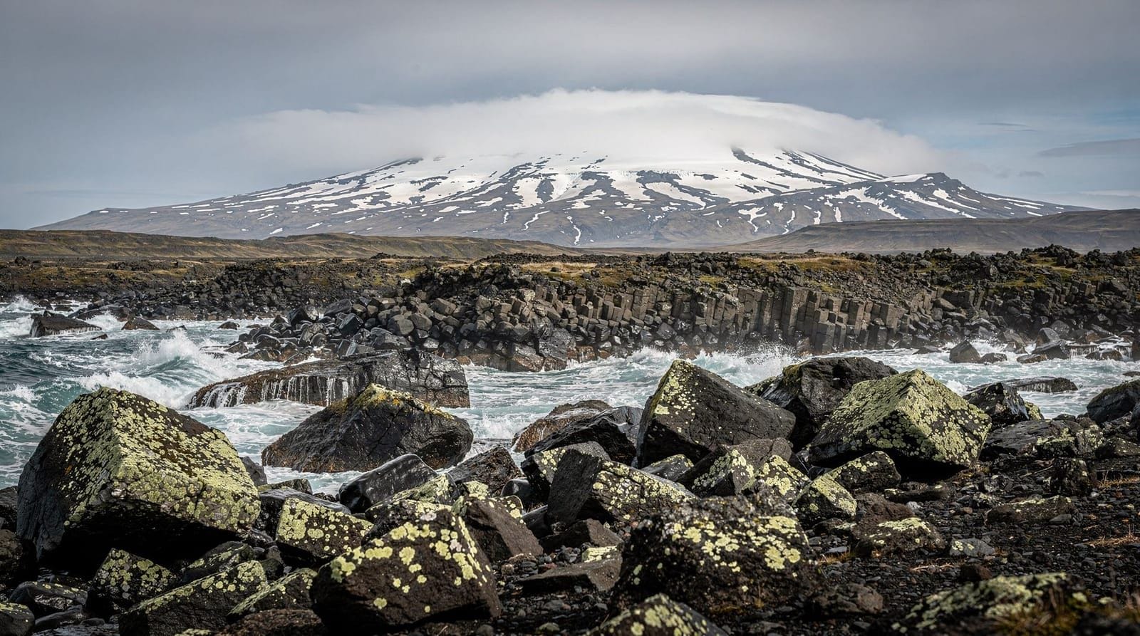
Snæfellsjökull National Park
Snæfellsjökull National Park protects the glacier-capped volcano at the peninsula tip and the surrounding lava and coastal landscape. The glacier summit (1,446 m) is accessible by snowmobile tour or glacier hike with a guide. The road through the national park (Route 570) runs below the glacier with close-up views.
Vatnshellir lava cave sits within the park — guided 45-minute tours explore the volcanic tube that formed 8,000 years ago. Bring warm layers regardless of surface temperature.
Allow: 1–2 hours including Vatnshellir.
Ytri Tunga seal beach
On the south coast of the peninsula, 28 km east of the national park, Ytri Tunga is Iceland’s most reliable and photogenic seal hauling beach. Harbour seals — typically 20–50 animals — rest on rocks immediately offshore from a small sandy beach. In June–July, seal pups are visible alongside adults.
No facilities, no fees. Walk from the rough car park across a small field to the beach. Stay on the grass above the beach to observe without disturbing.
Allow: 30–45 minutes.
Búðakirkja (Búðir black church)
Just east of the national park on the south shore, a gravel track leads to the Búðir black church — a small 19th-century wooden church on a promontory between lava field and bay. The glacier rises behind it. This is one of the most frequently photographed spots in Iceland and deserves its reputation.
The adjacent Hótel Búðir is Iceland’s most romantic country hotel (doubles from ~45,000 ISK / €293 in summer) — the restaurant serves high-quality Icelandic cuisine with local produce.
Allow: 15–20 minutes for photography.
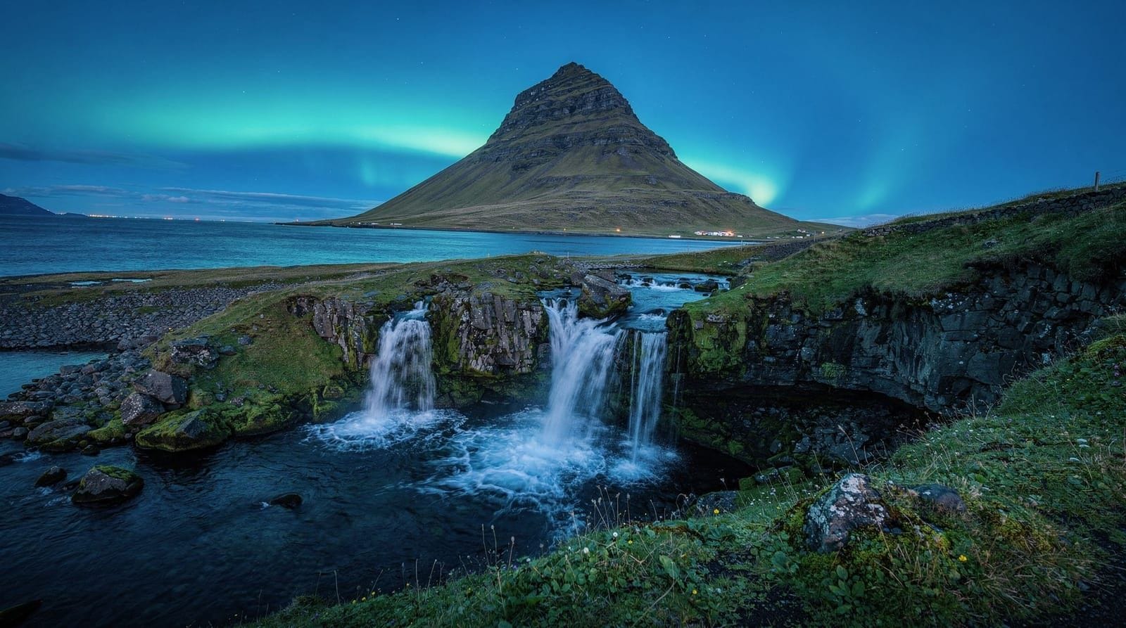
Kirkjufell and Kirkjufellsfoss
Kirkjufell is the 463 m mountain on the north shore of the peninsula near Grundarfjörður, recognisable by its distinctive steep, symmetrical shape. Kirkjufellsfoss — a cascade of waterfalls in the foreground — provides the classic compositional setup that made this Iceland’s most-photographed mountain.
Getting the photograph: the iconic composition has Kirkjufellsfoss in the foreground with Kirkjufell behind. A wide-angle lens (24–35mm) works best. Best light: sunrise (around 03:30–04:30 in June) or sunset (around 23:00–00:00). The parking area fills in July by 09:00.
Climbing Kirkjufell: there is no maintained trail to the summit. The mountain is steep and technically demanding. Guided climbs are available from Grundarfjörður; independent summit attempts have resulted in rescue call-outs.
Allow: 30–45 minutes (photography and waterfall walk).
Self-driving the peninsula circuit
Route: Reykjavík → Borgarnes (Route 1 north) → Snæfellsnes south shore (Route 54 west) → peninsula circuit → Grundarfjörður and Kirkjufell (north shore, Route 54 east) → back via Route 54 to Borgarnes → Reykjavík.
Total distance: approximately 360–380 km. Total driving time (no stops): about 5 hours. Allow 10–11 hours with stops.
The route is paved throughout in summer. The inner road across the peninsula tip (Route 570) is a good gravel road suitable for 2WD. No river crossings.
Guided tours
Snæfellsnes full-day guided tour — Kirkjufell, Arnarstapi, Ytri Tunga, Búðakirkja, Snæfellsjökull, English guide, hotel pickupGuided tours depart Reykjavík at around 08:00–09:00 and return by 20:00–21:00. They include the main stops with expert commentary on geology, folklore, and wildlife. Good value for solo travellers; less flexible than self-driving for groups who want extended time at specific stops.
Private guided tours allow more flexibility in the schedule and are worth the premium if Kirkjufell photography is the primary goal (you can request a sunrise or sunset departure).
Private Snæfellsnes day tour from Reykjavík — flexible schedule, dedicated guide, sunrise/sunset departures availableAdding whale watching to Snæfellsnes
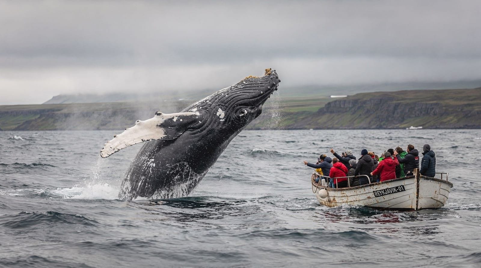
Some operators run whale and dolphin watching trips from the Arnarstapi and Grundarfjörður harbours during summer. These combine well with a Snæfellsnes day trip, particularly because the north coast of the peninsula faces Breiðafjörður bay (rich in white-beaked dolphins) and the approaches to the Faxaflói/Breiðafjörður junction have regular minke and humpback sightings.
In winter (October–February), Grundarfjörður is one of the best sites in Iceland for orca sightings as herring concentrate in the fjord.
Overnight option
The Snæfellsnes Peninsula rewards a 2-day visit — a 2-day Snæfellsnes itinerary allows more time at each stop and adds options like a snowmobile tour on the glacier, hiking in the national park, and exploring the Westfjords-facing bays at the peninsula’s western tip.
Accommodation on the peninsula: Hótel Búðir (luxury), Hótel Hellnar, Snæfellsbær guesthouses in Ólafsvík and Grundarfjörður. Book 2–3 months ahead in July.
Tips for the day trip
Arrive at Kirkjufell early: the car park fills before 09:00 in peak season. Arrive at 07:30 for the best light and the best parking.
Seal behaviour at Ytri Tunga: observe from the grass above the beach, not the beach itself. Approaching too close to the water’s edge causes the seals to flush into the sea, stressing them unnecessarily. Binoculars are useful.
Weather at the peninsula tip: Snæfellsjökull creates its own weather and can be cloud-covered even when Reykjavík is sunny. The tip of the peninsula is exposed to Atlantic weather. Bring full rain gear.
Fuel: fill up at Borgarnes before entering the peninsula. The next reliable petrol station is Ólafsvík on the north coast (about 2.5 hours from Borgarnes). Prices on the peninsula are slightly higher than in Reykjavík.
Frequently asked questions about the Snæfellsnes day trip
Is Snæfellsnes better than the Golden Circle?
Different rather than better. The Golden Circle has the historical weight of Þingvellir and the crowd-pleasing reliability of Strokkur. Snæfellsnes has more visual variety, fewer crowds in summer, and a wilder, more remote feel. For photographers and repeat visitors, Snæfellsnes often wins.
Can I see the Northern Lights from Snæfellsnes?
Yes — the peninsula is an excellent aurora location in autumn and winter due to low light pollution and the dramatic silhouette of Kirkjufell against a dark sky. The famous Kirkjufell aurora photograph has made this one of Iceland’s most iconic winter images.
Is the Snæfellsnes Peninsula the same as the Westfjords?
No. The Snæfellsnes Peninsula is a distinct peninsula in west Iceland, accessible in a day from Reykjavík. The Westfjords are a separate, much larger, and more remote region 2–3 hours north of Snæfellsnes. The Baldur ferry connects the two across Breiðafjörður.
How cold is it on the Snæfellsnes Peninsula?
The peninsula is exposed to Atlantic wind and fog. Summer temperatures (July) average 10–14°C but feel much cooler with wind. The glacier summit can be 0°C or below on any day. Bring layers, waterproof outer shell, and warm gloves regardless of the forecast.
Snæfellsnes in depth: beyond the day trip highlights
The standard day trip circuit covers the headline stops efficiently, but several lesser-visited locations are worth knowing:
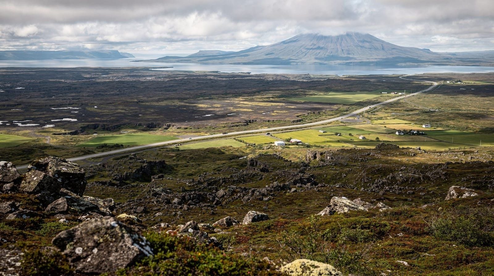
Vegamót viewpoint (Route 54 near Grundarfjörður): a mountain pass viewpoint that looks back east down Grundarfjörður fjord with Kirkjufell visible in the middle distance. One of the best landscape compositions on the peninsula and rarely crowded.
Berserkjahraun lava field: a 4,000-year-old lava field on the north shore between Grundarfjörður and Stykkishólmur. The name comes from an Icelandic saga — two berserkers (raging Viking warriors) were promised farmland if they cleared a path through the lava field, then killed afterward. The lava field has an eerie, otherworldly character and the remains of the cleared path are still visible.
Stykkishólmur: the largest town on the peninsula (about 1,200 people), sitting on a fjord with a distinctive volcanic island (Súgandisey) accessible by a short staircase. The town has a charming harbour, good accommodation options, and the Norska húsið (Norwegian House) museum. It is also the departure point for the Baldur ferry to the Westfjords.
Snæfellsjökull glacier tours: several operators run snowmobile tours on the glacier year-round (departing from the road below the glacier cap). These take 1.5–2 hours and include snowmobile driving across the ice field. A glacier hike option (with crampons and guide) allows access to the lower ice. Both activities can be booked through the national park visitor centre.
Vatnshellir cave: a 8,000-year-old lava tube beneath the national park, accessible by guided tour (45 minutes, including a 35 m descent). The tour is genuinely atmospheric — lava stalactites, complete darkness, and the geology of the tube explained by the guide. Tours depart every hour in summer; advance booking recommended.
Snæfellsjökull and Jules Verne
Jules Verne’s 1864 novel “Journey to the Centre of the Earth” (Voyage au centre de la Terre) uses Snæfellsjökull as the fictional entrance point for the underground journey. Professor Lidenbrock deciphers a runic code pointing to the Snæfellsjökull crater as the gateway, and the novel’s protagonists descend from the glacier into the Earth.
Verne never visited Iceland — he based his descriptions on other travellers’ accounts. But the choice of Snæfellsjökull was not arbitrary: the volcano is at Iceland’s western extreme, has a historical eruption record, and the glacier-capped cone rising from the sea had a sufficiently mysterious quality for fictional purposes.
Today the association is acknowledged with modest signage at the glacier; the French visitors who come specifically to stand at the “entrance to the Earth” are a small but consistent presence among the general summer tourism.
Food and fuel logistics
Best lunch on the peninsula: Arnarstapi village has Snjófell café and the adjacent Langaholt farm restaurant — the latter is better for a sit-down meal (fish and lamb dishes, ~2,500–3,500 ISK / €16–23 per main). Grundarfjörður has a small supermarket and a grill restaurant. Stykkishólmur has the most options if you are taking the northern shore approach.
Fuel: fill up at Borgarnes (N1 station on the Ring Road) before entering the peninsula. Next reliable station is Ólafsvík on the north shore (about 2.5 hours from Borgarnes). If you are making the full circuit, you will not run out, but do not start the peninsula with less than half a tank.
Accommodation for an overnight: Hótel Búðir (luxury, book 3–4 months ahead in July), Hótel Hellnar (mid-range, great location near the coast), and Ölverk guesthouses in Stykkishólmur and Ólafsvík. The peninsula books up in summer — accommodation should be secured well in advance.
The Snæfellsnes Peninsula compared to other day trips
Unlike the Golden Circle (primarily geological features and history) or the South Coast (waterfalls and dramatic beach), Snæfellsnes offers a broader palette:
- A working glacier accessible by snowmobile or hike
- Coastal scenery combining basalt formations, seabirds, and seal beaches
- A photogenic mountain that has achieved international recognition (Kirkjufell)
- Folklore and literary history (Eiríks saga, Bárðar saga, Jules Verne)
- Quieter communities with fewer tourist facilities (which is a feature, not a bug)
The trade-off is distance — a day trip from Reykjavík is genuinely long. For visitors with two nights based in Reykjavík, an overnight stay on the peninsula (depart Day 1 afternoon, return Day 3 morning) adds depth without excessive driving.
See our 2-day Snæfellsnes itinerary for a structured overnight plan.
Frequently asked questions about Snæfellsnes day trip from Reykjavík
What are the highlights of the Snæfellsnes Peninsula?
Kirkjufell mountain and Kirkjufellsfoss, Snæfellsjökull glacier (volcano and national park), Arnarstapi and Hellnar basalt coastline, Ytri Tunga seal beach, Búðakirkja black church, and the Vatnshellir lava cave. The peninsula can be circuited in a day but rewards a 2-day visit.Is Kirkjufell hard to reach?
No — Kirkjufell sits directly beside Route 54 on the north shore of the Snæfellsnes Peninsula, 3 km east of Grundarfjörður. There is a large car park. The waterfall Kirkjufellsfoss is a 3-minute walk from the car park. The mountain itself requires a guided climb (no marked trail to the summit; the approach is technical).How long is the drive from Reykjavík to Snæfellsnes?
About 2 hours to Kirkjufell via Route 54 north of the peninsula, or about 2.5 hours via the south shore approach via Borgarnes. The two routes together form the peninsula circuit — most self-drivers enter via one shore and exit via the other.Should I go to Snæfellsnes or the Golden Circle?
For most first-time visitors, the Golden Circle has more famous individual stops (Þingvellir, Geysir, Gullfoss). Snæfellsnes offers a more varied, cinematic landscape and fewer crowds. If you are doing 3 days of day trips from Reykjavík, do both. If you can only choose one and are primarily interested in photography or coastal scenery, Snæfellsnes.What is the Búðakirkja?
Búðakirkja (Búðir Black Church) is a small, isolated black-painted wooden church from the 19th century, set against a lava field with the Snæfellsjökull glacier as backdrop. It is one of Iceland's most photographed subjects — the stark black building against the white glacier and green field is compositionally excellent.Can I see the Snæfellsnes Peninsula in winter?
Yes — the peninsula is particularly beautiful in snow and winter light. Kirkjufell with snow and the northern lights above it is one of Iceland's iconic winter images. The road is kept open in winter but conditions can be icy. A 4WD is recommended November–March.
Top experiences
Bookable activities with verified prices and instant confirmation on GetYourGuide.
Top experiences
Best-rated activities across GetYourGuide and Viator.

From Reykjavik: Snaefellsness Peninsula small group day tour
- Viator

Lake Myvatn Day Tour and Godafoss Waterfall for Cruise Ships from Akureyri Port
- Viator

Private Jökulsárlón Glacier Lagoon 2 Day Tour & Glacier Hike
- Viator

From Reykjavik: Katla Ice Cave and South Coast Day Tour
- Viator

Reykjanes Peninsula Private Day Tour - up to 9 passengers
- Viator

Thorsmork Hike Day Tour
- Viator