Iceland volcanoes guide — which to visit and what to expect
Iceland: Fagradalsfjall Volcano hike small group local guide
Duration: 4-6 hours
Which Icelandic volcanoes can tourists actually visit?
Fagradalsfjall on the Reykjanes Peninsula is the most accessible active volcano, with eruptions between 2021 and 2023 and ongoing geological activity. Askja, Hekla, and Katla are major systems with scenic access but no current active eruptions. Guided hikes are the safest approach for all volcanic terrain.
Iceland has 130 volcanic systems, of which 30 have been active in the last 1,000 years and about a dozen are considered high-probability for activity in the near term. This is not a theoretical geological fact — it means the country regularly reinvents portions of its own landscape. Three eruptions occurred between 2021 and 2023 on the Reykjanes Peninsula alone, creating lava fields that will be part of the landscape for millennia.
This guide explains which volcanic sites are accessible and worth visiting, what the experience involves, and how to approach the more remote systems safely.
Reykjanes Peninsula — Iceland’s most active current zone
The Reykjanes Peninsula, 30–50 km southwest of Reykjavík, entered a period of volcanic unrest in 2020 that shows no signs of stopping. Before 2021, the peninsula had not seen eruptions in 800 years. Since then, eruptions at Fagradalsfjall (2021, 2022, 2023) and near Grindavík (2023–2024) have produced multiple km² of new lava.
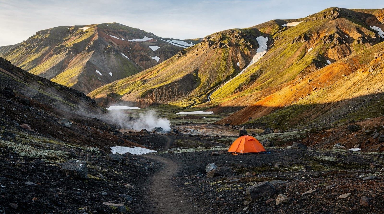
Fagradalsfjall
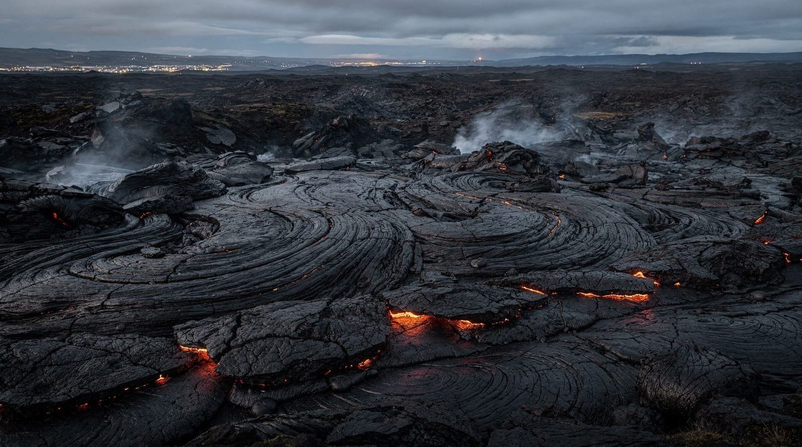
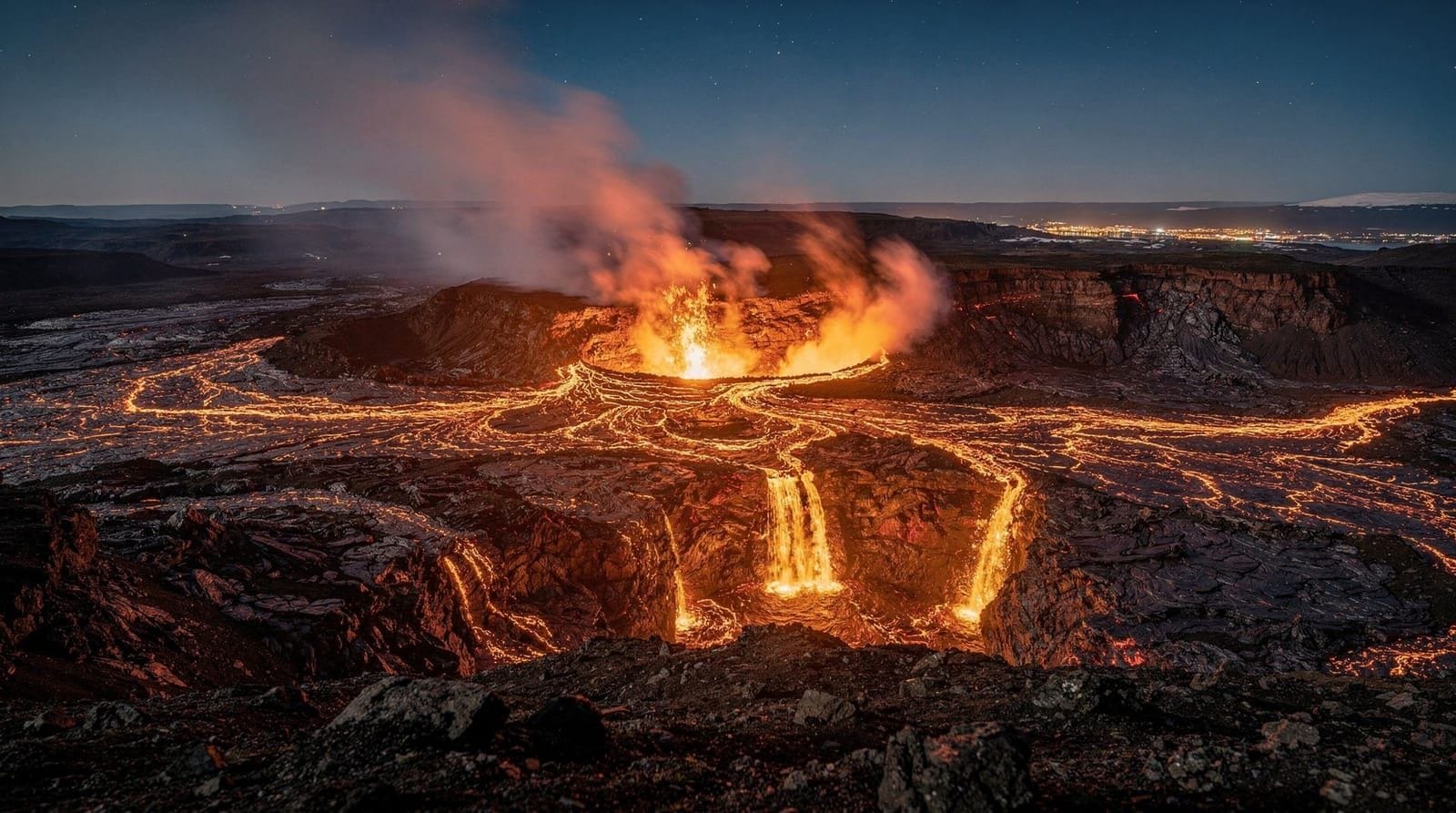
The Fagradalsfjall volcanic system is the most accessible active volcanic landscape in Iceland. The three eruption sites between 2021 and 2023 are now solidified lava fields, but the landscape they created is extraordinary — a moonscape of collapsed lava tubes, pressure ridges, and still-warm rocky terrain.
The hike to Geldingadalir valley (the 2021 eruption site) is 8 km return from the Suðurstrandarvegur road parking area, taking approximately 3–4 hours. The terrain is challenging — uneven hardened lava that requires proper hiking boots and concentration — but is not technically demanding. No climbing equipment needed.
Guided volcano hikes with a geologist explain the lava types (pahoehoe vs aa lava, lava tubes, tephra layers) in ways that transform a landscape walk into a coherent story. The geologist guides can also advise on current volcanic monitoring status and what current activity, if any, is occurring nearby.
See the complete Fagradalsfjall eruption guide for specific access details, current status, and photography advice.
Svartsengi and the Blue Lagoon connection
The Blue Lagoon sits on the edge of the Svartsengi geothermal field, which is connected to the same Reykjanes volcanic system. The 2023–2024 eruptions near Grindavík temporarily closed the Blue Lagoon and required partial evacuation of the town. The lagoon has reopened and the town continues to function, but this is a genuine active volcanic zone, not a former one.
Major volcanic systems elsewhere in Iceland
Hekla
Hekla is Iceland’s most historically active stratovolcano and one of the most feared in European medieval mythology (it was called “the Gateway to Hell” in 12th-century sources). It erupted in 1947, 1970, 1980, 1991, and 2000. It is considered overdue for its next eruption.
The approach to Hekla is open to hikers when no eruption is ongoing. The summit hike (1,491 m) takes approximately 4–5 hours return from the standard trailhead near Landmannalaugar road. Guides are strongly recommended. When Hekla erupts, it typically gives only minutes of warning — a very different risk profile from Fagradalsfjall’s slower effusive eruptions.
Katla
Katla is a subglacial volcano beneath the Mýrdalsjökull glacier, with a caldera 10 km in diameter. Its last confirmed eruption was 1918. Katla is considered overdue — the average interval between eruptions is 50–80 years, and it is one of Iceland’s most closely monitored volcanoes.
You cannot visit Katla itself. You can visit the Kötlujökull glacier tongue and experience glacial caves formed in the Mýrdalsjökull ice above it. These tours operate under strict safety protocols because Katla’s potential for a sudden subglacial eruption (jökulhlaup — glacial flood) makes the area genuinely hazardous without local expert knowledge.
Askja
Askja is a remote caldera complex in the highland interior, 200 km east of Akureyri. The caldera contains two nested calderas, one filled by the lake Öskjuvatn (Iceland’s deepest at 220 m) and a smaller caldera, Víti, which contains a geothermal pool warm enough to swim in (around 23–25°C, though access changes seasonally).
Accessing Askja requires crossing highland F-roads (F88 or F910), only passable in July–August, and requires a 4WD. The standard approach from the north takes approximately 3 hours from Mývatn and involves a 2.5 km hike to the Víti crater. See the F-roads Iceland guide.
Small-group volcano hikes at Fagradalsfjall provide safety briefings, current monitoring updates, and geologist narration. The group size matters for this specific hike — smaller groups can move more safely on uneven lava terrain than large tours.
Eyjafjallajökull
Eyjafjallajökull erupted in April–May 2010, disrupting European air travel for weeks. The volcano is a stratovolcano beneath a glacier of the same name on the south coast. The 2010 eruption created a new lava field on the glacier’s south side and deposited ash across the entire region.
The glacier and surrounding area is now accessible for glacier hiking and jeep tours. The eruption site itself has merged with the glacier ice. You can see the ashfall landscape from the south coast road — the farms in the valley below were buried under ash and later cleared.
Grímsvötn
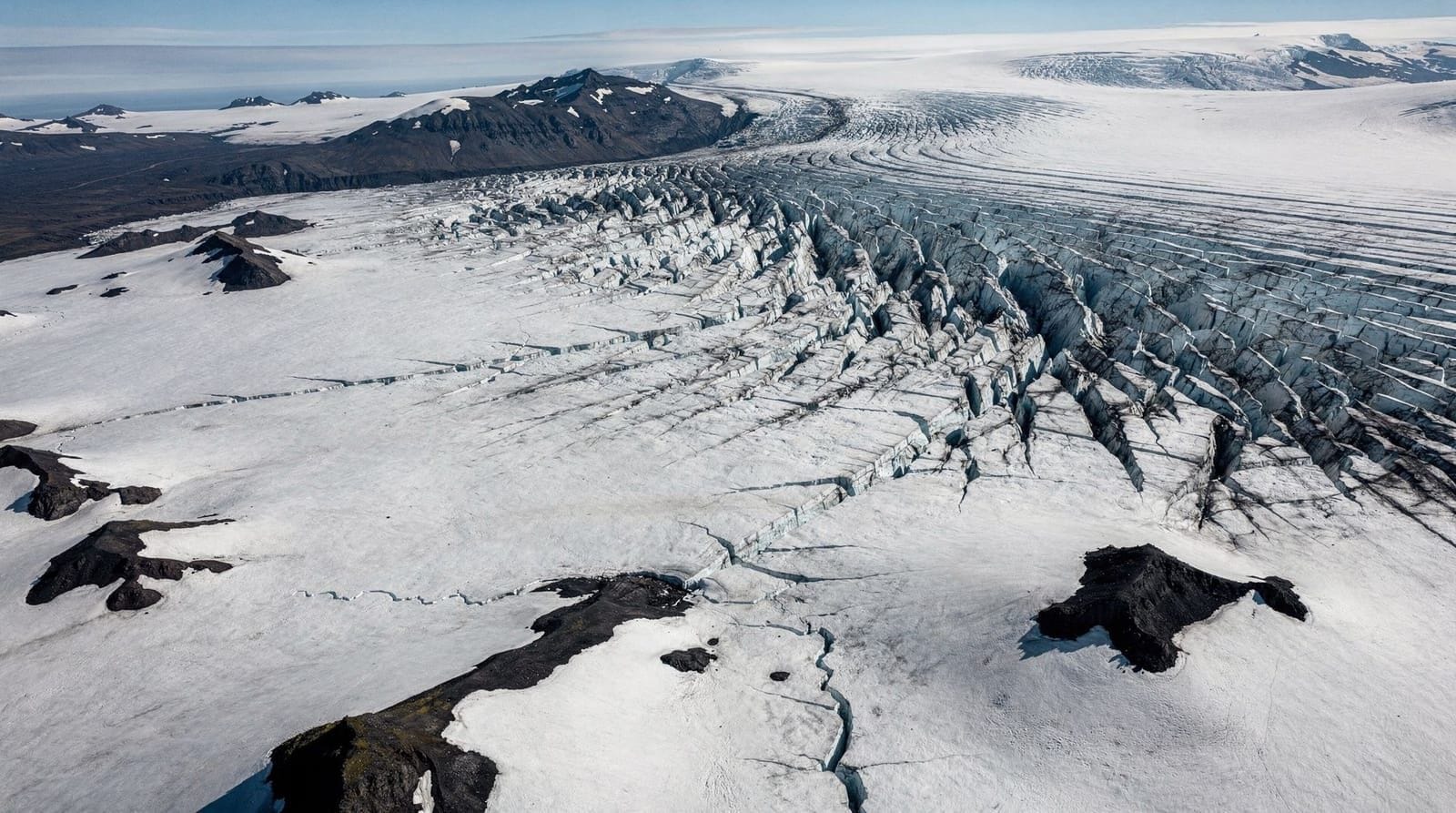
Grímsvötn is Iceland’s most frequently active volcano, located beneath Vatnajökull glacier. It erupts roughly every 5–10 years; the 2011 eruption was the most powerful since 1918. You cannot visit Grímsvötn itself — it’s deep under the glacier in a restricted zone. But Vatnajökull National Park surrounds the glacier, and glacier hikes and ice cave tours operate in the area.
Volcanic geology basics — understanding what you’re seeing
Iceland sits on the Mid-Atlantic Ridge, where the Eurasian and North American tectonic plates are separating at approximately 2.5 cm per year. This spreading, combined with a mantle hotspot beneath the island, creates the condition for both effusive (lava flows) and explosive (ash cloud) eruptions.
Effusive eruptions (like Fagradalsfjall 2021–2023): lava exits relatively peacefully through fissures and vents, flowing slowly. Safe to observe from distance. The 2021 eruption was unusual in global terms for being accessible to the public.
Subglacial eruptions (like Eyjafjallajökull 2010): ice melt creates explosions that generate ash clouds. Not safe to observe at close range.
Lava types:
- Pahoehoe (smooth, ropy surface) — lava that flowed slowly and cooled with a rubbery skin
- Aa (rough, jagged surface) — faster-moving lava that broke up its own crust during flow
- Tephra — explosive ejected fragments, ranging from fine ash to large bombs
All three types are visible on the Fagradalsfjall lava fields from the 2021–2023 eruptions.
Safety and current monitoring
Iceland’s Meteorological Office (vedur.is) and the Institute of Earth Sciences at the University of Iceland provide real-time monitoring data for all major volcanic systems. Before visiting any volcanic area, check:
- Current status on vedur.is (English version available)
- The IMO hazard alerts (issued when activity increases)
- Safetravel.is for current access restrictions
The Reykjanes Peninsula remains in a period of elevated volcanic activity as of 2026. The specific eruption sites are typically accessible when no active lava flow is present, but the overall area should be treated as volatile.
Always register your hiking plan at safetravel.is before entering volcanic terrain.
Frequently asked questions about Iceland’s volcanoes
Is it safe to visit volcanic areas in Iceland?
Yes, with appropriate precautions. Effusive eruption sites like Fagradalsfjall (post-eruption) are safe for hiking when officially open. Areas with active lava flows are restricted by authorities. Subglacial and explosive volcanic systems require guided access and current monitoring checks.
Can I see an active lava eruption?
Possibly, depending on when you visit Reykjanes. The peninsula has been erupting periodically since 2021. If an eruption is ongoing during your visit, authorities may open specific viewing areas if the lava flow is stable and slow. There are no guarantees. Check vedur.is current alerts.
What should I do if a volcanic eruption starts while I’m nearby?
Follow evacuation directions from authorities immediately. Iceland has a well-established volcanic emergency response. Safetravel.is has emergency contacts and protocols. The main risk from sudden eruptions is volcanic gas (sulfur dioxide) — move upwind immediately if you detect a sulfur smell.
How do I get to Fagradalsfjall from Reykjavík?
Drive south on the Reykjanesbraut (Route 41) toward Keflavík airport, then turn onto Route 427 or 426 toward Grindavík/Þórbjörn. Multiple trailheads exist with varying distances to the eruption sites. Without a car, tours depart from Reykjavík daily. See the Fagradalsfjall eruption guide.
What is the largest volcanic eruption in Iceland’s history?
The 1783–1784 Laki eruption in south Iceland is considered the most catastrophic — it created a 130 km fissure, emitted enough sulfur dioxide to create acid rain across Europe, and caused crop failures that killed 25% of Iceland’s population. The fissure system is visible in the highlands near Kirkjubæjarklaustur but requires 4WD access. See the Iceland in summer guide for highland access timing.
Is Iceland’s volcanic activity increasing?
The current period of elevated Reykjanes activity (from 2021) is consistent with geological cycles. The peninsula was similarly active roughly 800 years ago. Scientists consider the current activity likely to continue for decades, making Reykjanes a sustained geological event rather than a one-off. The rest of Iceland’s volcanic systems are not showing unusual activity beyond background levels.
How Iceland’s volcanic systems are monitored
Iceland has one of the most comprehensive volcanic monitoring networks in the world. The Icelandic Meteorological Office (vedur.is) operates GPS sensors, seismometers, tiltmeters, and gas sensors across the country. When activity increases, alert levels rise automatically based on sensor data.
For tourists, the practical resources are:
- vedur.is: Real-time earthquake and volcanic activity maps, updated continuously
- safetravel.is: Compiled safety alerts and access restrictions
- road.is: Road closures, including volcanic and weather related closures
The system gives advance warning for slow-building eruptions (like Fagradalsfjall’s month-long run-up in early 2021) but limited warning for sudden events. The Katla and Hekla systems are capable of eruptions with very short warning times.
Understanding the different eruption types you may encounter
Iceland’s volcanoes produce different types of eruptions depending on the magma composition and the presence or absence of ice:
Fissure eruptions (Fagradalsfjall type): Lava erupts from a crack (fissure) in the ground, often several kilometres long. Lava flows outward at relatively low velocity (meters per hour). Generally the safest type for observers at appropriate distance.
Central volcano eruptions (Hekla, Katla type): Eruption from a central vent, potentially explosive depending on magma silica content. Hekla in particular can produce significant ash plumes and ballistic ejecta.
Subglacial eruptions (Grímsvötn type): Volcanic heat melts overlying glacier ice, creating a jökulhlaup (glacial flood). The steam explosions can be very violent. No safe viewing distance — these events are dangerous enough to prompt regional evacuations.
The Blue Lagoon and volcanic risk
The Blue Lagoon sits within the Svartsengi geothermal field on the Reykjanes Peninsula, directly in the zone of current elevated volcanic activity. The lagoon was temporarily closed during the 2023–2024 Grindavík eruption series and has been rebuilt/restored.
Visitors should know this context: the Blue Lagoon is operating in a volcanic active zone. The facility has evacuation procedures; staff are trained for this. The risk on any specific day is low, but it is not zero in the way that, say, visiting a waterfall in Norway carries essentially zero volcanic risk.
For most visitors, this context simply adds to the Iceland experience rather than creating a reason not to go. But it is worth knowing before you book.
Volcano tourism — the ethical question
The 2021 Fagradalsfjall eruption brought enormous numbers of visitors to an active lava field. At peak activity, tens of thousands of people were hiking to the eruption site, some getting uncomfortably close to active lava flows. Several people were injured; some needed helicopter rescue.
The tension: an active eruption is genuinely one of the most spectacular natural events on Earth, and Iceland’s effusive lava eruptions are less immediately lethal than explosive ones. But the crowd at Fagradalsfjall during peak activity was unsafe by any professional geological assessment.
If a new eruption occurs during your visit, the appropriate approach is: wait for official viewing areas to be established by authorities, follow their stated safe distances, do not attempt to get “just a little closer” than the guidelines, and accept that the best experience from a safe distance is better than the closest experience from an unsafe one. See the safetravel.is guide for Iceland emergency procedures.
Tour options for volcano experiences
Guided Fagradalsfjall hikes
Several operators run guided volcano hikes from Reykjavík to Fagradalsfjall, ranging from half-day to full-day options. Guide quality varies significantly — the best guides are certified local geologists who provide meaningful scientific context; the worst are recreational guides reading from a script.
What to look for in a Fagradalsfjall guide:
- Geological background or certification
- Current monitoring update at the start of the tour
- Small group size (fewer than 12 is better for safety on uneven lava)
- Flexibility to extend or change route based on conditions
Avoid: large bus-format tours that drop you at the trailhead for a self-guided walk with minimal briefing. These do not provide safety value; you’d be better self-driving and registering your plan at safetravel.is.
Helicopter volcano tours
Helicopter tours over the Reykjanes volcanic area operate during and between eruptions, providing aerial perspectives of the lava fields. These are expensive (60,000–100,000 ISK / €400–660 per person) but offer views of lava landscape extent that are impossible to appreciate from ground level. See the volcano helicopter tours guide for operator comparison.
Eyjafjallajökull jeep tours
Super-jeep tours up the Eyjafjallajökull volcano flanks access the glacier surface and the 2010 eruption area. The eruption crater is on the glacier summit, requiring a snowmobile or tracked vehicle. These tours offer context about the eruption that caused global aviation disruption — explained on-site by guides who actually experienced it.
Planning a volcano-focused Iceland trip
A volcano-focused Iceland itinerary works best if structured around Reykjanes (accessible from Reykjavík as day trips), with a highland component if visiting in July–August.
3-day volcano focus from Reykjavík:
- Day 1: Fagradalsfjall lava field hike (see Fagradalsfjall eruption guide)
- Day 2: Reykjanes Peninsula circuit — Gunnuhver geothermal, lighthouse, Blue Lagoon
- Day 3: Eyjafjallajökull jeep tour from south coast base
This covers three completely different volcanic experiences: solidified lava fields, active geothermal surface features, and a glacier-covered volcano summit.
For a more comprehensive geology itinerary covering Hekla, Askja, and the highlands, plan a 7–10 day trip with a 4WD and highland road access. The Iceland self-drive guide covers the logistics of this type of trip. See also the Ring Road 10-days itinerary.
Top experiences
Bookable activities with verified prices and instant confirmation on GetYourGuide.
Top experiences
Best-rated activities across GetYourGuide and Viator.

Ice Cave by Katla Volcano Super Jeep Tour from Vik
- Viator

Puffin and Volcano Tour with Ebbi
- Viator

Dynjandi Waterfall & Farm Visit Tour from Isafjordur Port
- Viator

3,5-Hour Sightseeing Tour To Dynjandi Waterfall
- Viator

Volcano ATV Tour
- Viator

Lake Myvatn Day Tour and Godafoss Waterfall for Cruise Ships from Akureyri Port
- Viator