Fagradalsfjall volcano — Reykjanes eruption site
Hiking guide for Fagradalsfjall volcano: trail access, eruption history since 2021, gas hazards, gear checklist, and logistics from Reykjavík.
Reykjavik: From Reykjavik Fagradalsfjall Volcano hike with geologist
Quick facts
- Best time to visit
- June–September for best trail conditions; can be icy in winter
- Days needed
- Half-day from Reykjavík; allow 4–6 hours including travel
- Getting there
- 40 km from Reykjavík; car park on Suðurstrandarvegur (Route 427)
- Budget per day
- Car park fee ~500 ISK / €3.40; trail access free; tours from €59
The eruption history since 2021
Fagradalsfjall is a tuya (a flat-topped volcanic mountain formed by eruptions beneath a glacier) on the Reykjanes Peninsula, approximately 40 kilometres southwest of Reykjavík. Before 2021, the Reykjanes Peninsula had been volcanically dormant for roughly 800 years.
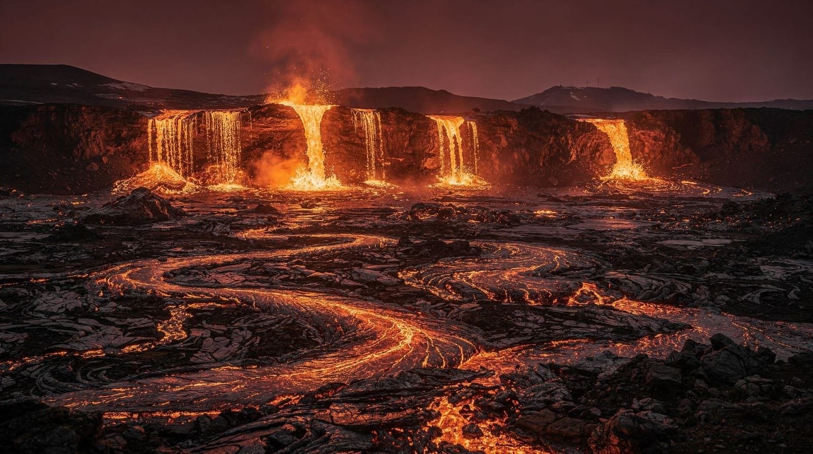
On March 19, 2021, a fissure opened in Geldingadalir valley at the base of Fagradalsfjall, beginning the first Reykjanes eruption in modern memory. The eruption was characterised by slow-moving lava flows building new land over weeks and months, with no explosive phase — making it one of the safest eruption types to observe from a controlled distance. Hundreds of thousands of visitors hiked to the lava field during the 2021 eruption, making it one of the most-visited geological events in Iceland’s history.
Further eruptions followed:
- August–September 2022: A brief eruption at Meradalir, northeast of the Geldingadalir site
- July 2023: Eruption at Litli-Hrútur, further northeast along the Fagradalsfjall system
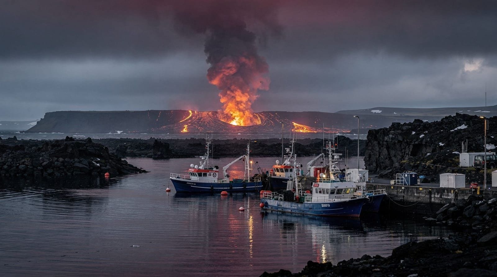
- 2023–2024: The eruptive activity shifted to the Sundhnúkur crater row, a distinct fissure system closer to Grindavík (see the grindavik destination page for the impact on the town)
The result is a landscape of multiple overlapping lava fields — different ages, different textures — extending across several square kilometres north of Grindavík and south of the Fagradalsfjall massif. The most recent flows are black and ropy; older flows have begun developing the characteristic grey weathering surface.
Trail access in 2026
Trail access to the Fagradalsfjall area is managed by the Suðurnes municipality and varies depending on current volcanic conditions. As of 2026, the main access point for the cooled Geldingadalir lava fields (2021 eruption) and Meradalir area is the Suðurstrandarvegur car park on Route 427, near the Reykjanesvegur junction.
A small car park fee applies (approximately 500 ISK / €3.40 via a machine or app). The trail is not a formal maintained path in the conventional sense — it crosses lava fields and uses waymarked routes. The ground is uneven; fresh lava is extremely sharp and can slice through lightweight footwear. Proper hiking boots are required, not just trail running shoes.
Distance and time: The round-trip hike to the nearest 2021 lava fields (Geldingadalir crater area) takes approximately 3–4 hours. Reaching the further Meradalir flows adds 1–2 hours. The terrain is demanding not because of elevation but because of the surface: crossing fresh lava requires concentration to avoid twisted ankles.
Check current trail conditions on the Suðurnes municipality website and on safetravel.is before visiting. After rainfall, lava surfaces can be slippery. In winter and early spring, snow and ice on lava fields significantly increases difficulty and risk.
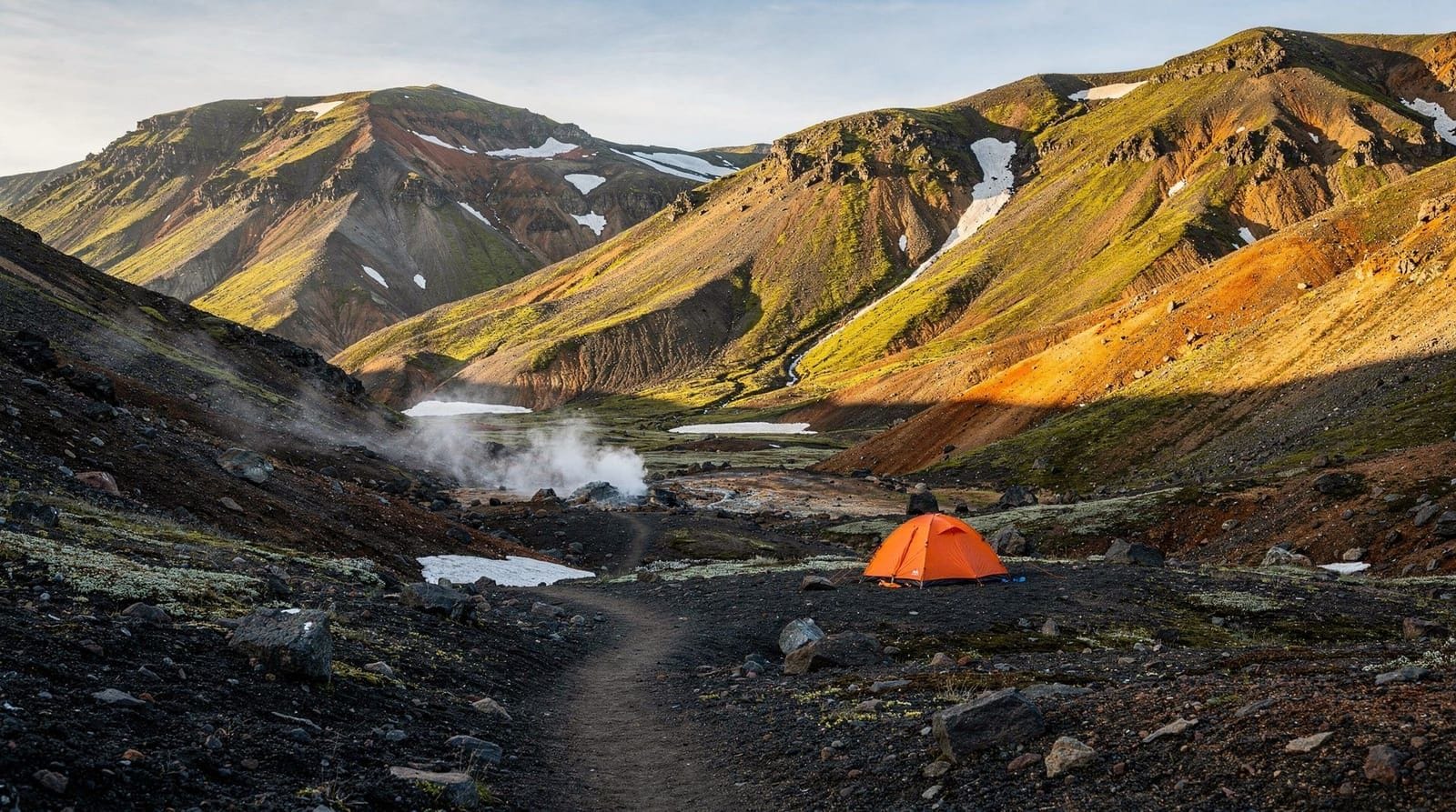
What you see on the hike
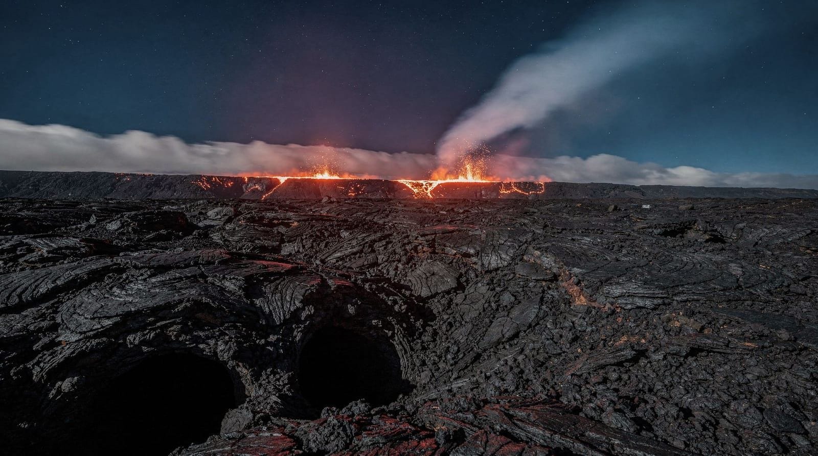
Geldingadalir crater area: The 2021 eruption built a shield volcano — a broad, low dome with a central vent. The crater is approximately 15–20 metres across and is now cold. Surrounding lava flows show the ropelike pahoehoe texture from slow lava movement; further from the vent, the faster-moving aa lava created rougher, blocky surfaces.
Meradalir: The 2022 eruption site, slightly further northeast, added a second lava field that partially overlaps with 2021 flows. The terrain is similar — black basalt, steaming vents (in places where the lava is cooling from below), and reddish oxidised zones near where the lava was hottest.
Litli-Hrútur (2023): The July 2023 eruption at Litli-Hrútur was briefly more explosive than its predecessors and the approaches require additional walking time. Confirm trail access status before targeting this specific area.
On clear days, the surrounding landscape provides context: Fagradalsfjall mountain to the west, the Svartsengi geothermal power plant visible to the north (its plumes of steam are a constant reference point), and on the clearest days, glimpses of the Snæfellsjökull glacier to the north-northwest.
Gas hazards and safety
The primary safety concern at volcanic hiking areas is volcanic gas, particularly sulphur dioxide (SO₂). During active eruptions, SO₂ concentrations near the vent can reach dangerous levels within minutes when wind direction shifts. Even at cooled lava fields, gas emissions can occur from cooling rock and residual activity.
The Icelandic Meteorological Office publishes a volcanic gas forecast (vedur.is/english/volcanoes/gas-forecast/) that gives SO₂ risk levels for different areas and wind directions. Check this before visiting. If the gas hazard is orange or red for the Reykjanes area, postpone your visit or stay well upwind of the vent area.
Never enter active exclusion zones — these are set based on real-time monitoring of gas, seismic, and ground deformation data. The exclusion zones during eruptions are not conservative estimates; they are based on actual hazard data.
A gas mask (for SO₂, not a simple particle mask) is recommended for visits to recently active areas. The type needed is an A2/B2 rated filter mask, available at hardware stores in Iceland. This is not standard tourist equipment and most visitors do not carry one; if you stay upwind and at the cooler, western portions of the lava field, the risk in inter-eruption periods is low.
Fagradalsfjall volcano hike from Reykjavík with geologist guideGuided tours vs self-guided hiking
A significant number of visitors choose guided tours for the Fagradalsfjall hike. The case for guided tours:
- Logistics: Pickup from Reykjavík eliminates the need for a car
- Context: Geologist or volcanologist guides explain what you’re seeing; the lava textures, crater formation, and geological sequence are far more meaningful with explanation
- Safety: Guides monitor conditions and know when to turn back
- Current intel: Guides know the current trail conditions and access points, which change as new lava flows alter the landscape
The case for self-guided: You control the pace, you save the tour cost (typically €59–€120 per person), and you can respond to conditions more flexibly if you know what you’re doing.
For visitors with limited Iceland experience, guided is the more reliable choice. For experienced hikers who have read current trail information carefully, self-guided is entirely feasible.
Fagradalsfjall volcano hike with small group and local guideEquipment checklist
- Sturdy hiking boots (ankle support; lava destroys thin soles)
- Wind and waterproof outer layer (the peninsula is extremely exposed)
- Hat and gloves (even in summer, wind makes it cold quickly)
- 2 litres of water minimum (no water sources on the trail)
- Snacks for energy on a 4–6 hour outing
- Headlamp in shoulder seasons when days are shorter
- Camera with dust protection if available (lava dust is fine and abrasive)
Getting there without a tour
By car from Reykjavík: Route 41 west toward Hafnarfjörður, then south on Route 43, then east on Route 427 (Suðurstrandarvegur). Follow signs for Fagradalsfjall car parks. Journey time approximately 45–50 minutes from central Reykjavík.
There is no public bus service to the trailhead. Taxis from Reykjavík for a half-day would cost approximately 15,000–20,000 ISK (€100–€135) one way — a rental car or tour is more cost-effective for most visitors.
Combining with other Reykjanes sites
The Fagradalsfjall area is most logically combined with a broader Reykjanes Peninsula circuit. From the Fagradalsfjall car park area, Gunnuhver (the hot spring and steam field) is about 20 kilometres southwest; Krýsuvík is about 15 kilometres northeast; the Blue Lagoon is about 10 kilometres northwest.
The fagradalsfjall-eruption-guide has a detailed look at the geological context, eruption sequence, and what’s visible at each site. The iceland-volcanoes-guide provides broader context on Icelandic volcanic types and safety.
For those combining the volcano with a day in Reykjavík, the reykjavik-stopover-3-days itinerary suggests a Reykjanes Peninsula day as part of a multi-day Reykjavík stopover structure.
What the lava landscape looks like up close
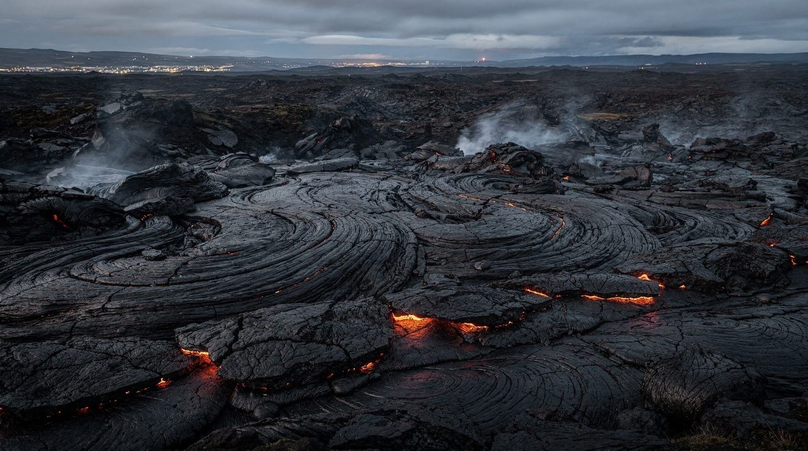
The experience of walking through fresh lava fields is unlike any other terrain. Pahoehoe lava (from the Hawaiian term for smooth, ropy lava) forms when lava cools slowly from the outside while still flowing inside — the surface wrinkles into twisted, rope-like ridges. The 2021 Geldingadalir flows are primarily pahoehoe, and the visual effect is extraordinary: the lava appears to have solidified in motion, frozen mid-flow with ropes and spirals across the surface.
Older sections of the field have developed vesicular texture — full of small holes from gas bubbles trapped as the lava cooled. These holes make the surface more abrasive and less predictable underfoot. The darker black of fresh lava transitions over years to grey as the surface weathers.
Temperature is still a factor at recently cooled lava. In some sections, you can feel heat rising through boot soles from lava that continues to cool slowly below the surface. Steam vents — small holes where groundwater contacts hot rock — emit white steam at temperatures well above boiling at the point of contact. Do not kneel down near steam vents or approach them closely.
The scale of the 2021–2024 flows is significant: the combined area of new lava covers several square kilometres. Standing at the edge of the main flow field, the volume of material — all of it erupted from the earth in the past five years — provides a visceral sense of geological scale.
Photography at Fagradalsfjall
The lava landscape offers consistently good photographic material. Key factors:
Light: The low-angle light of early morning and late afternoon (long in Iceland’s summer) produces dramatic shadow and texture on the ropy pahoehoe surfaces. Midday flat light flattens the texture.
Composition: The contrast between fresh black lava and the older brown/red of Fagradalsfjall mountain behind it provides good compositional depth. The Svartsengi steam plumes visible to the northwest can anchor wide-angle shots.
Equipment: Lava dust is fine, pervasive, and abrasive. Protect camera equipment. Dedicated cameras benefit from a sealed bag when not in use; sensor cleaning after the trip is worth considering.
Drone rules: Iceland’s drone regulations apply in full. Drones require registration and operators must follow ICETRA (Icelandic Transport Authority) rules, including restricted zones around active volcanic areas. Check the drone-rules-iceland guide before bringing equipment.
The Reykjanes volcanic system in broader context
Geologists describe the Reykjanes Peninsula as entering a new eruptive cycle — a period of increased activity that may last decades, comparable to the last active period 800 years ago. The eruptions since 2021 are not isolated events but part of a recognisable pattern of rifting activity along the Mid-Atlantic Ridge where it surfaces in Iceland.
This context matters for visitors: the Fagradalsfjall and Sundhnúkur eruptions are likely to continue in some form for years. This means that the opportunity to see genuinely fresh volcanic landscape — in some cases weeks or months old — will persist. It also means that the specific accessible areas will change as new flows alter the terrain. Checking current conditions before any visit is not a one-time step but an ongoing requirement if you’re planning far in advance.
The iceland-volcanoes-guide situates the Reykjanes activity within Iceland’s broader volcanic geography, including the other major systems (Katla, Hekla, Grímsvötn, Bárðarbunga) and their respective risk profiles.
Wildlife and plants on the lava fields
Fresh lava fields appear biologically barren at first — the black rock surface has no visible soil, no rooted plants. Look more carefully and the first colonisers are already visible within a year or two of the lava cooling: black mosses (particularly woolly fringe moss, Racomitrium lanuginosum) begin establishing on the lava surface, gradually breaking down the rock and creating the organic material that eventually allows flowering plants to colonise.
On the 2021 lava fields at Geldingadalir — now 5 years old — early moss colonisation is visible in sheltered pockets and on the cooler outer edges of the flow. This is the beginning of the ecological succession that over decades and centuries will transform the bare lava into the moss-covered fields that cover much of the older Reykjanes landscape.
Bird life: Ravens (hrafn) and fulmars are common over the lava fields year-round, using the updrafts from the black rock surface (which heats rapidly in sunlight). Arctic skuas patrol the area in summer. The lava fields themselves provide no nesting habitat, but the adjacent older terrain does.
After the hike: recovery and onward
The Fagradalsfjall car park area has no food or drink facilities. The nearest options:
- Keflavík: 30–35 km northeast, 30 minutes — full range of cafes and supermarkets
- Grindavík: 10–12 km southwest — cafes if currently open (check status)
- Blue Lagoon: 10 km northwest — café and restaurant (expensive but accessible, pre-booking required for the lagoon itself)
Many visitors combine the Fagradalsfjall hike with a Blue Lagoon visit on the same day, using the spa as a recovery option after the hike. This works logistically if you book the Blue Lagoon for a mid-afternoon or late-afternoon slot, giving you the morning for the volcano hike. The contrast of volcanic hiking followed by warm geothermal bathing is a common and practical Reykjanes day structure.
The reykjavik-stopover-3-days itinerary incorporates a Reykjanes Peninsula day that includes the volcano hike and Blue Lagoon as a combined experience.
Frequently asked questions about Fagradalsfjall volcano
Is Fagradalsfjall currently erupting?
Volcanic activity in the Reykjanes Peninsula is ongoing but not continuously erupting. Eruptions have occurred in episodes since 2021, with periods of quiet between. Check vedur.is (Icelandic Meteorological Office) for current activity levels. The site is hike-accessible during inter-eruption periods.
Can I hike to the volcano without a guide?
Yes, during inter-eruption periods when the area is officially open. The trail is not technically demanding but requires proper footwear and weather-appropriate clothing. Check current conditions on safetravel.is and vedur.is before going. The gas hazard forecast should be checked, particularly for SO₂ levels.
How difficult is the Fagradalsfjall hike?
Moderate. Not technically climbing — no ropes, no steep pitches — but the lava surface is extremely uneven and requires concentration. Expect 3–4 hours round-trip to the nearest crater. Good physical fitness is helpful; the challenge is foot placement rather than aerobic intensity.
What is the best time of year to hike Fagradalsfjall?
June to September, when snow has melted and days are long. The trail can be done in shoulder seasons (May, October) but snow and ice on lava are hazardous. Winter visits are possible with appropriate crampons and gear, but conditions change rapidly. July and August have the most stable conditions and longest daylight.
How close can I get to the crater?
At cooled sites (2021, 2022 eruption areas), you can walk directly to and around the crater rim during open periods. At active or recently active sites, exclusion zones apply and are enforced. Never attempt to approach active lava flows — they can move faster than appears from a distance and gas hazards are severe near active vents.
Is this a tourist trap?
No. The Fagradalsfjall lava fields are a genuine geological site — new land created by volcanic activity within the past five years. There is minimal commercialisation (a small car park fee, some tour operators). The hiking experience is raw, uncurated, and physically demanding in a way that distinguishes it from most tourist sites.
Top experiences
Bookable activities with verified prices and instant confirmation on GetYourGuide.
Top-rated experiences in Fagradalsfjall volcano — Reykjanes eruption site
Best-rated activities across GetYourGuide and Viator.