Grindavík — Iceland's volcanic fishing town
Honest guide to Grindavík: 2023–2024 volcanic eruptions, current access status, Blue Lagoon proximity, and what remains open on the Reykjanes Peninsula.
Grindavik: Blue Lagoon premium admission drinks face masks
Quick facts
- Best time to visit
- Check current access restrictions before planning any visit
- Days needed
- Half-day combined with Blue Lagoon or peninsula circuit
- Getting there
- 45 min southwest of Reykjavík; 20 min from KEF Airport
- Budget per day
- Low if passing through; no significant paid attractions in town
Understanding Grindavík in 2026
Grindavík is a fishing town of approximately 3,400 people on the south coast of the Reykjanes Peninsula, about 45 minutes southwest of Reykjavík and 4 kilometres south of the Blue Lagoon. Before 2023, it was a quietly functioning fishing community — the second-largest town on the Reykjanes Peninsula after Keflavík, known primarily for its fish-processing industry and proximity to the Blue Lagoon.
That changed significantly in November 2023, when the town was evacuated following ground deformation and seismic swarms that preceded eruptions at the Sundhnúkur crater row, a volcanic system running directly through the southern edge of Grindavík. Subsequent eruptions in 2024 sent lava flows toward parts of the town, and a section of houses and infrastructure on the western side of Grindavík was damaged or destroyed.
As of 2026, Grindavík’s status as a safe, fully accessible destination for tourism depends on current volcanic alert levels. Before visiting Grindavík or the southern Reykjanes Peninsula, check the Icelandic Meteorological Office (vedur.is) and the Civil Protection Authority (almannavarnir.is) for the current alert level and any exclusion zones. This is not precautionary language — the ground around Grindavík remains geologically unstable.
The town before the eruptions: what it was
For context on what Grindavík is as a community: it developed primarily as a fishing and fish-processing hub. The harbour handles trawlers and smaller fishing vessels; the saltfish industry (salted and dried Atlantic cod, or saltfiskur) has been economically central since the 19th century.
The small town centre along Víkurbraut had a few cafes, a bakery, and the regional sports and community centre. The Saltfish Museum (Saltfisksetur) documented the history of the Icelandic saltfish industry with genuine historical detail — a niche but interesting exhibit for visitors interested in how Iceland’s economy was built. Whether these facilities remain fully operational depends on the current state of the town post-eruptions.
The fishing harbour (Grindavíkurhöfn) was one of the more accessible working harbours to view from a visitor perspective — smaller than Keflavík’s commercial port, but active enough to see fishing boats and processing operations.
The 2023–2024 eruptions: what happened
Iceland sits on a hotspot and on the Mid-Atlantic Ridge — a combination that makes it among the most volcanically active countries on earth. The Reykjanes Peninsula, which had been quiet for roughly 800 years before 2021, entered a new period of intense activity beginning with the Fagradalsfjall eruption in March 2021.
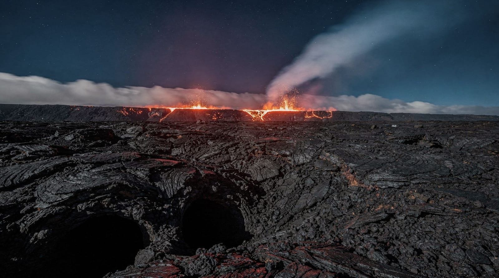
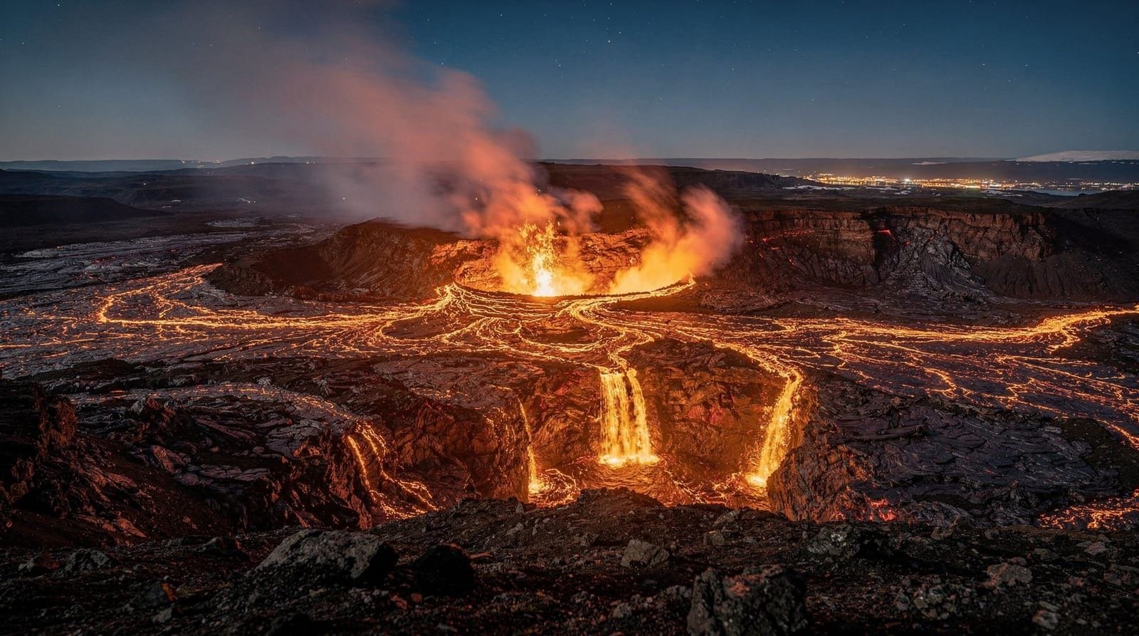
The Sundhnúkur crater row — a fissure system running northeast to southwest through the southern Reykjanes area, approximately 4 kilometres northeast of central Grindavík — began showing signs of instability in late 2023. In November 2023, GPS measurements detected rapid ground subsidence beneath Grindavík (the ground dropped up to 1 metre in some areas within days), indicating magma movement underground. The entire town was evacuated.
An eruption began northeast of Grindavík in December 2023. Further eruptions followed in January, May, and subsequent months of 2024, with lava flows reaching the defensive earthworks constructed by emergency services around the western edge of Grindavík. Some houses on Grindavík’s western outskirts were burned. The Blue Lagoon was evacuated and temporarily closed multiple times.
This ongoing volcanic sequence represents a genuine geological emergency for the community — not a tourist spectacle. The residents of Grindavík face continued uncertainty about whether their town is permanently safe for habitation.
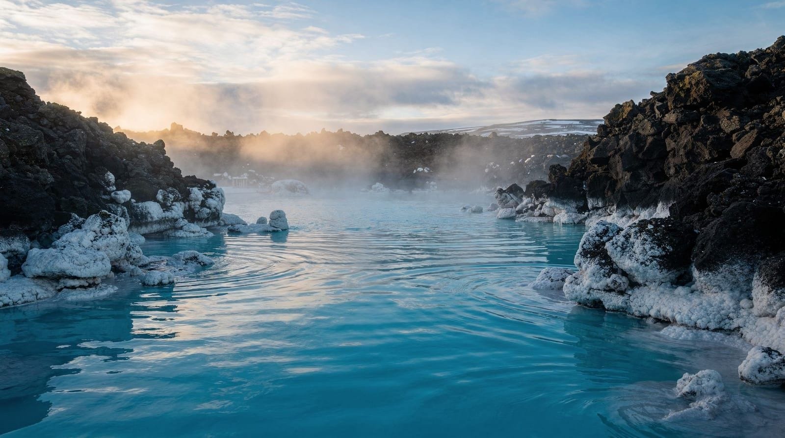
The Blue Lagoon’s relationship to Grindavík
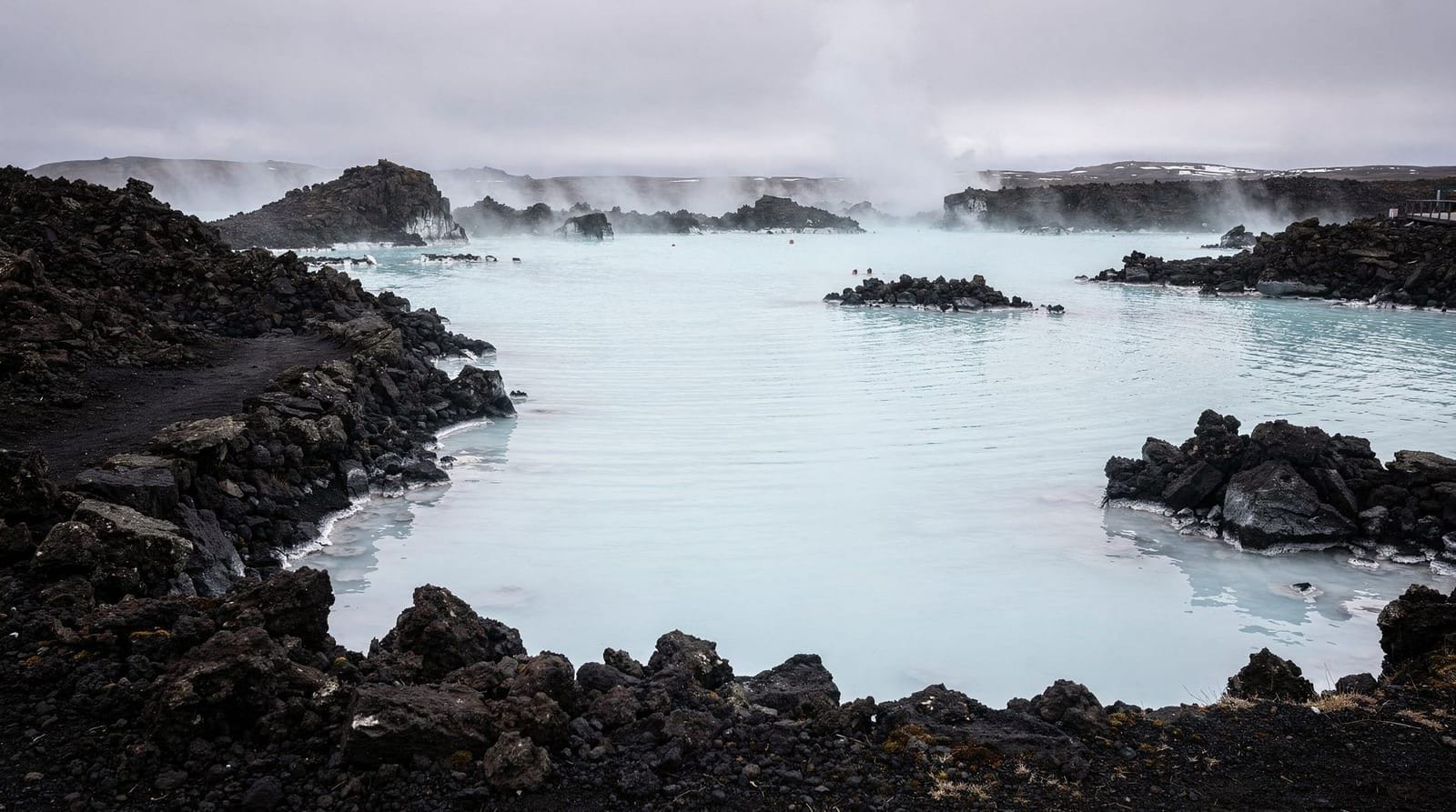
The Blue Lagoon sits approximately 4 kilometres north of Grindavík town centre, between the town and KEF Airport. It draws its water from the Svartsengi geothermal power plant, which sits about 2 kilometres northeast of the lagoon.
The Blue Lagoon has, as of 2026, reopened and operates normally. The eruptions of 2023–2024 prompted multiple temporary closures and an evacuation of the facility. The spa’s geological situation — sitting in a lava field on an active volcanic ridge — is unchanged. The Blue Lagoon management monitors volcanic conditions continuously and has an evacuation protocol.
Blue Lagoon Premium admission with drinks and face masksFor visitors concerned about safety at the Blue Lagoon: the risk is managed, not absent. The facility is built in a geologically active zone and operates with awareness of that fact. If you’re uncomfortable with that context, the Sky Lagoon in Reykjavík is outside the volcanic zone.
Fagradalsfjall volcano and the broader eruption landscape
The Fagradalsfjall volcanic system (which produced the 2021–2024 eruptions in the Geldingadalir/Meradalir valley, about 8 kilometres northeast of Grindavík) is distinct from the Sundhnúkur crater row that threatens Grindavík. Hiking to the Fagradalsfjall lava fields — which has been accessible to visitors since the lava cooled — is conducted from a car park on Route 427 (Suðurstrandarvegur), north of the active Grindavík exclusion zones. See the fagradalsfjall-volcano destination page for current trail access.
Practical guidance for visiting Grindavík area
If Grindavík has returned to normal access when you visit (check current status before travel):
- The harbour walk and the old fishing district are modest but functional
- The Saltfish Museum is worth 45–60 minutes for those interested in the local industry
- Grindavík has a petrol station (useful for Reykjanes Peninsula circuits) and a small supermarket
- Several cafes and the Bryggjan restaurant (a beloved local fish soup institution, if still operating) served the fishing community; verify current opening before relying on them
If Grindavík has partial or full access restrictions when you visit:
- The Blue Lagoon is accessible regardless of Grindavík town restrictions (different access road from the north)
- The Reykjanes Peninsula circuit through Gunnuhver and Krýsuvík can be done without entering Grindavík
- Stay on designated routes; do not attempt to enter exclusion zones to see lava fields
The Saltfish Museum and local food heritage
The Saltfish Museum (Saltfisksetur Íslands) on Hafnargata documents Iceland’s saltfish industry — arguably the economic foundation of the modern Icelandic state. Saltfish (dried and salted Atlantic cod) was Iceland’s primary export product for centuries and funded the country’s development from a subsistence agricultural economy into a modern state. The museum traces the history from medieval fisheries through to the industrial processing of the 20th century.
This is a niche attraction but genuinely interesting for visitors curious about the economic and cultural history of Iceland beyond the volcanic tourism narrative. Entry costs approximately 1,500–2,000 ISK (€10–€14); the current operational status should be verified given the town’s recent disruptions.
Bryggjan Cafe (the Harbour Cafe) on the waterfront was long considered one of the best fish soup stops in Iceland — a simple, unfussy place serving langoustine and fish soup in a working harbour environment. Whether it remains open and in its original form as of 2026 depends on the current state of the town’s business district. This type of authentic, local-economy dining is exactly what gets disrupted by volcanic emergencies, and confirming opening before making a trip specifically for it is essential.
The fishing harbour
The Grindavík harbour handles trawlers and smaller fishing vessels targeting the cod, haddock, and capelin that Icelandic fishing towns have depended on historically. The harbour area, when accessible, gives a clear view of operational fishing vessels and the supporting infrastructure — fish processing, ice facilities, fuel supply.
For visitors who haven’t seen a working Icelandic fishing harbour, Grindavík (or Keflavík, if Grindavík is restricted) provides a ground-level view of an industry that remains central to the Icelandic economy. Iceland’s fishing sector accounts for a significant share of export earnings; the harbour towns are where the reality of that economy is visible.
The historical Grindavík before 2023
For context on what was at stake in the 2023–2024 emergency: Grindavík has been a settled community since the Saga Age. The name derives from “grind” (a gate or palisade) and “vík” (a bay). The settlement grew through the medieval period primarily as a trading and fishing location; the saltfish industry that dominated the Icelandic export economy from the 14th through 20th centuries was conducted from towns exactly like Grindavík.
The community had a stable, if modest, infrastructure: a primary school, a sports hall, a community swimming pool (Grindavíkurlaug — geothermally heated, entry approximately 1,100 ISK / €7.50 when operational), a library, and the normal services of an Icelandic town of 3,000 people. The volcanic emergency disrupted this ordinary life in ways that are not adequately conveyed by the dramatic imagery of lava flows.
The importance of this context is that Grindavík’s residents have a legitimate stake in how tourism engages with their town’s situation. If you visit, treat it as a community, not a disaster attraction.
Road access and infrastructure
Grindavík is accessed from the north via Grindavíkurvegur (Road 44) from Suðurstrandarvegur (Road 427), or from the northeast via the Blue Lagoon access road (Route 43 junction). The road network around Grindavík may have modifications since the eruptions — defensive earth barriers, rerouted access, or closed sections. Follow official route guidance and do not deviate from marked roads.
The Blue Lagoon is accessible via a dedicated road from the north (Bláalónsvegur) that bypasses Grindavík town entirely. Even if Grindavík is under access restrictions, the Blue Lagoon access route has generally remained open unless there is an active eruption event at Svartsengi/Sundhnúkur directly.
Resources for current conditions
- vedur.is: Icelandic Meteorological Office — publishes daily volcanic and seismic updates, hazard maps, and eruption situation reports in English
- almannavarnir.is: Civil Protection Authority — posts current alert levels and exclusion zones
- safetravel.is: Iceland Search and Rescue’s travel safety advice, including current road and area closures
- The safetravel-emergency-info guide has further practical guidance for staying informed in Iceland
The community context
It is important to acknowledge that Grindavík is a real community that has experienced a serious geological emergency — not a tourist spectacle. The eruptions of 2023–2024 disrupted the lives of several thousand people, damaged property, and created ongoing uncertainty about the safety of the town. Some residents chose to relocate permanently; others returned when conditions permitted.
Visiting Grindavík (if and when it is accessible) means interacting with a town in recovery. The fish processing industry, the harbour, the local shops and cafes that form the economic fabric of the community — these are the real Grindavík, not the volcanic emergency. Treating the visit with appropriate consideration for the local experience (rather than approaching it primarily as an access point to see lava) is the appropriate attitude.
This is distinct from visiting the Fagradalsfjall volcano hiking area, which is geologically separate and does not directly impact the Grindavík community.
How this area connects to Iceland’s broader volcanic story
The Reykjanes Peninsula eruptions are part of a pattern that geologists have documented in Iceland’s geological record: periods of intense rifting activity lasting 20–40 years, separated by periods of relative quiet lasting centuries. The last such period on the Reykjanes Peninsula ended approximately 800 years ago. The current sequence, beginning in 2021, appears to be the opening of a new active period.
Understanding this context changes how you experience the Reykjanes Peninsula. The landscape you’re driving through — black lava, geothermal fields, volcanic ridges — is not stable. It is actively forming and reforming on a geological timescale that occasionally intersects with human timescales in the way it has for Grindavík’s residents. The iceland-volcanoes-guide provides the broader scientific context for Iceland’s volcanic systems and what distinguishes the Reykjanes situation from other volcanic zones in the country.
Frequently asked questions about Grindavík
Is Grindavík safe to visit in 2026?
Safety depends entirely on current volcanic activity and alert levels. The town has been fully open during inter-eruption periods and under evacuation during active phases. Check vedur.is and almannavarnir.is for current status before planning any visit. The situation can change within days.
Can I visit the Blue Lagoon if Grindavík is restricted?
Yes. The Blue Lagoon is accessed via a different road (from the north, Route 43 and the Grindavíkurvegur turn-off near Svartsengi) and is not affected by town-level restrictions unless there is an active volcanic emergency at the Svartsengi/Sundhnúkur system specifically. Check the Blue Lagoon’s own website for operational status.
Is the Grindavík area worth visiting for tourists?
Before the 2023–2024 eruptions, Grindavík was a working fishing town that tourists passed through on the way to Blue Lagoon — it was not a destination in itself. Post-eruption, it is primarily a community dealing with geological disaster. Tourist interest in the area is best directed to the Reykjanes Peninsula’s geothermal and geological sites and to the Blue Lagoon, rather than the town itself.
Why did lava flow toward Grindavík specifically?
The Sundhnúkur crater row runs through the southern Reykjanes Peninsula in a northeast–southwest orientation. Grindavík lies at the southwestern end of this fissure system. When eruptions began along the fissure, lava flowed downhill (southward) toward the coastal town. Emergency earth barriers were constructed in late 2023 to divert potential lava flows, but the geological situation remained active through 2024. This is an ongoing situation, not a historical event.
Can I see the Grindavík lava fields?
Areas of fresh lava from the 2024 eruptions may be visible from public roads and viewpoints, subject to current exclusion zones. The iceland-volcanoes-guide gives context on viewing active volcanic areas safely. Do not enter exclusion zones, and do not drive on lava or off designated roads.
Top experiences
Bookable activities with verified prices and instant confirmation on GetYourGuide.
Top-rated experiences in Grindavík — Iceland's volcanic fishing town
Best-rated activities across GetYourGuide and Viator.