Fagradalsfjall eruption guide — visiting Iceland's new lava fields
Reykjavik: Fagradalsfjall Volcano hike
Can I still visit the Fagradalsfjall eruption sites?
Yes. The 2021–2023 lava fields are accessible when no active eruption is ongoing. The Geldingadalir valley (2021 eruption) is the most visited — 8 km return hike, 3–4 hours. The Meradalir and 2022/2023 sites are closer to the road but through rougher terrain. Check vedur.is for current volcanic status before going.
Between March 2021 and July 2023, the Fagradalsfjall volcanic system on the Reykjanes Peninsula produced three separate eruptions that reshaped a significant section of southwest Iceland’s landscape. The eruptions were unusual globally — effusive fissure eruptions with lava fountains and rivers that moved slowly enough to be safe for the public to observe from designated viewing areas.
The lava has since cooled and solidified. The resulting landscape — several km² of black and rust-colored lava fields, collapsed lava tubes, and ash deposits — is one of the most accessible examples of fresh volcanic terrain on Earth. You can walk on lava that didn’t exist five years ago.
What happened at Fagradalsfjall
2021 eruption (March–September): The first eruption in the Reykjanes Peninsula in 800 years. A fissure opened in Geldingadalir valley on 19 March 2021 and erupted for nearly six months, producing approximately 140 million cubic metres of lava. The eruption was slow enough that tens of thousands of Icelanders and tourists hiked in to watch lava flowing within metres of the public.
2022 eruption (August–September): A new vent opened in Meradalir, a valley north of Geldingadalir, and erupted for approximately two months. This was a faster eruption with higher lava output.
2023 eruption (July–August): A third vent erupted in Litli-Hrútur area, producing flows that came within 3 km of the road infrastructure. This eruption lasted approximately 30 days.
The 2023–2024 eruptions near Grindavík town (Sundhnúkagígar system) are a separate fissure system, distinct from Fagradalsfjall proper but part of the same Reykjanes volcanic episode.
Accessing the eruption sites
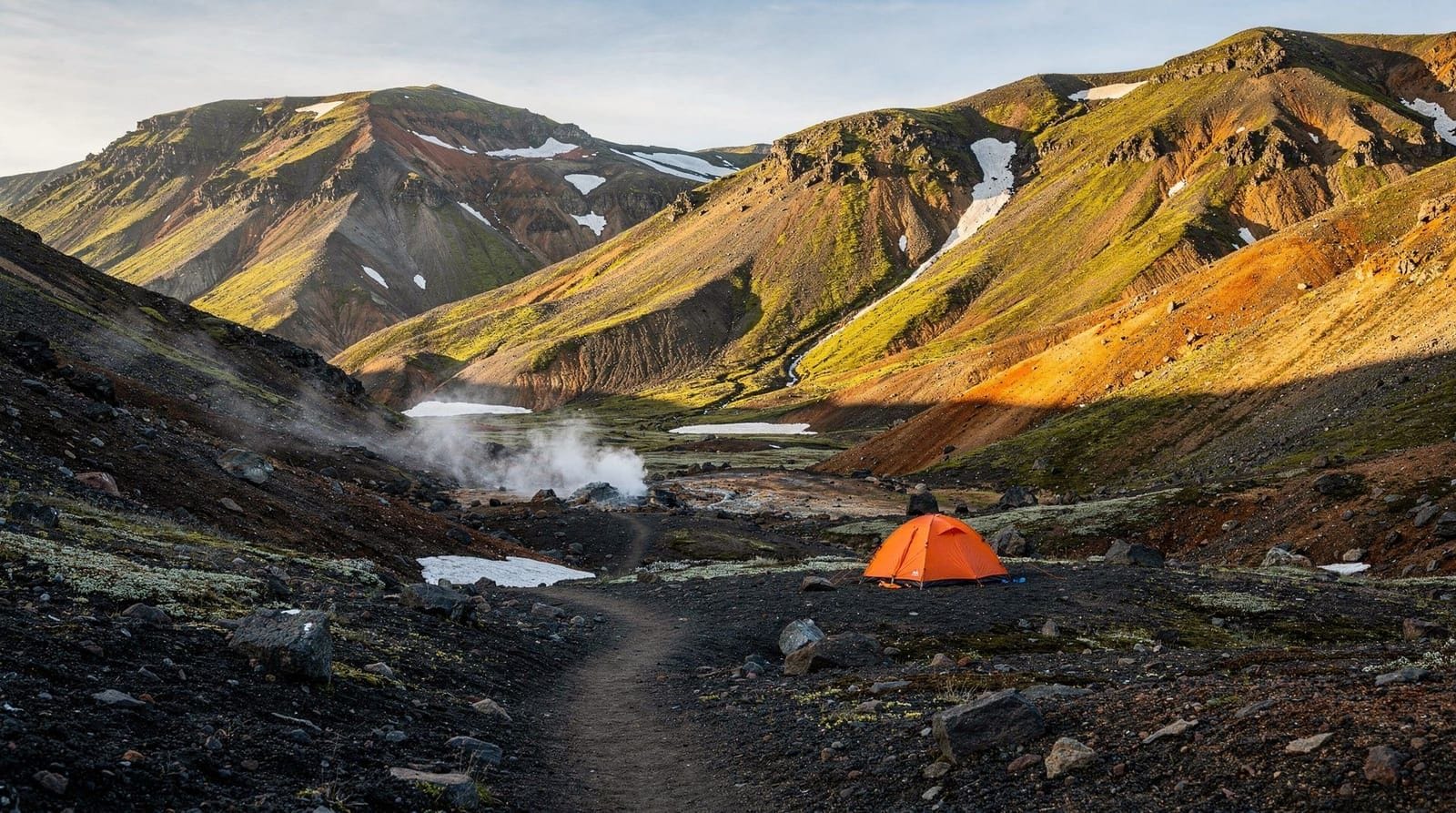
Geldingadalir (2021 eruption) — the main hiking destination
The Geldingadalir valley is the original and most visited eruption site. The hike begins from a parking area off Suðurstrandarvegur road (Route 427), approximately 40 km southwest of Reykjavík.
Distance: 8 km return (4 km each way) Elevation gain: Approximately 150 m Duration: 3–4 hours return at a moderate pace Terrain: Rocky trail, hardened lava, wooden boardwalk sections near the valley floor. Uneven but manageable in hiking boots. Not suitable for trail runners or flat-soled shoes. Signage: Well marked with cairns and wooden trail markers.
At the valley floor, you reach the 2021 eruption vent and its surrounding lava field. The cooled pahoehoe lava (smooth, ropy texture) and aa lava (rough, broken surface) are both present and clearly distinct. Lava tubes — hollow tunnels where lava flowed after the outer crust cooled — are visible along the trail.
Important: The ground is uneven and some sections are unstable. Follow marked paths; walking off-trail on fresh lava risks stepping through thin crusts into hollow tubes.
Meradalir (2022 eruption)
A second trail from the same parking area leads northeast into Meradalir valley, where the 2022 eruption vent is located. The hike is slightly longer (approximately 9 km return) and the terrain is rougher. The lava here is newer and the surface more jagged. Excellent for understanding the difference between the two eruption styles.
Litli-Hrútur area (2023 eruption)
The 2023 eruption site is accessible via a separate trailhead further east on Route 427. The eruption occurred closer to the road, making the approach shorter but the lava landscape less extensive. This area also shows fresh tephra deposits — ash and volcanic bombs scattered across the hillside.
Current status and safety
As of June 2026, no active eruption is ongoing at Fagradalsfjall. The solidified lava fields are open for hiking. However:
- The Reykjanes volcanic system remains in an active period. New eruptions are possible.
- When an eruption is ongoing, access to Fagradalsfjall may be restricted by authorities.
- The Grindavík/Sundhnúkagígar area (separate system) has seen ongoing instability — check current status at vedur.is before driving through Grindavík.
Before your hike:
- Check vedur.is for current volcanic alert levels
- Register your plan at safetravel.is
- Check road.is for Route 427 conditions (road may close when eruptions are active or wind is extreme)
A geologist-guided hike to Fagradalsfjall provides real-time volcanic monitoring context and expert identification of lava types, eruption features, and what the current geological situation means. The terrain interpretation alone makes a guide worth it for most visitors who aren’t geologically trained.
Self-driving to Fagradalsfjall
From Reykjavík, take Route 41 (Reykjanesbraut) southwest toward Keflavík, then Route 43 and Route 427 south. Total distance: approximately 50 km, 45–60 minutes depending on stops. The parking area is signposted from Route 427.
A standard 2WD is fine for this drive — all roads are paved or well-maintained gravel. No 4WD required.
Parking: Free at the main trailhead parking area. The lot fills quickly in summer (arrive before 9 am or expect a 15-minute walk from overflow parking).
Facilities: None at the trailhead itself. Bring water (at least 2 litres per person), food, and layers. The nearest services are at a petrol station near Grindavík or back toward the Blue Lagoon.
Combining with other Reykjanes sites
Fagradalsfjall pairs naturally with:
- Blue Lagoon: 20 km west. The geothermal spa sits in a lava field from a different era — an interesting contrast to the fresh Fagradalsfjall terrain. Booking required well in advance.
- Grindavík: Fishing town 8 km south of the main trailhead, accessible for food and fuel (check current town access status post-2023 eruptions).
- Reykjanes Peninsula full circuit: Lighthouse at Reykjanestá, Bridge Between Continents at Sandvík, geothermal area at Gunnuhver.
What to bring
This is a genuine outdoor hike over rough terrain, not a park boardwalk:
- Sturdy hiking boots (ankle support, good grip on wet rock)
- Waterproof jacket (weather changes rapidly on the peninsula)
- Warm mid-layer (wind chill on exposed ridges can be significant even in summer)
- 2 litres water minimum per person
- Food — there are no facilities on the trail
- Headtorch (useful even in summer if you hike late)
- Sun protection (clear days on the peninsula can be intense with no shade on lava fields)
What not to bring: Flip-flops, smooth-soled shoes, minimal water. These are regular causes of emergency callouts on the Fagradalsfjall trail.
Half-day guided tours to Fagradalsfjall from Reykjavík are a good option if you have limited time. Most operate on 5–6 hour total schedules including transport, which gives 2–2.5 hours on the lava field itself. Look for tours that include the 2021 Geldingadalir site rather than just the closer 2022/2023 areas.
Photography at the lava fields
The Fagradalsfjall terrain is visually distinct from every other Icelandic landscape — the palette is black, rust-red, and grey, with occasional yellow sulfur deposits and green moss beginning to colonise the edges of the oldest flows.
Compositions that work:
- Macro detail: pahoehoe lava rope structures, cooling cracks, tiny colonising plants
- Wide landscape: the lava field extending to the horizon with the volcanic cone behind
- Contrast: fresh black lava adjacent to green moss or grass at the lava flow boundary
- If you can arrange a blue-sky day: the contrast with the black lava is very strong
For the 2021 eruption cone, a telephoto lens from the valley rim gives better scale compression than wide angle.
See the Iceland photography guide for general advice on Icelandic landscape photography.
Frequently asked questions about Fagradalsfjall
Can I see lava flowing at Fagradalsfjall right now?
As of June 2026, the lava fields are solidified. No active eruption is ongoing at the main Fagradalsfjall system. The lava landscape is still dramatic and worth hiking. If new activity begins, check vedur.is.
How difficult is the Fagradalsfjall hike?
Moderate. The terrain is uneven hardened lava and requires concentration, but no climbing or technical skills are needed. Anyone in reasonable physical condition can complete the Geldingadalir return hike. Allow 3–4 hours. Difficult for those with balance or mobility issues due to the irregular surface.
Is it legal to take lava home from Fagradalsfjall?
Collecting lava or other geological materials from Icelandic nature reserves is illegal. The Fagradalsfjall area falls within the Reykjanes UNESCO Global Geopark — taking samples is prohibited and can result in fines.
Can I visit Fagradalsfjall without a guide?
Yes. The trail to Geldingadalir is well-marked and regularly visited. However, a guide adds significant value for geological context and current safety awareness. If you go independently, check vedur.is before departure and register your plan at safetravel.is.
What is the closest accommodation to Fagradalsfjall?
Keflavík and Grindavík both have accommodation options 15–20 km from the trailhead. Reykjavík (50 km) is the most convenient base for services. If you’re arriving or departing via Keflavík International Airport, Fagradalsfjall is a logical same-day addition to your itinerary.
How long will the Fagradalsfjall lava landscape last?
The solidified lava will persist essentially permanently on the geological timescale. Within human timescales, moss and vegetation will begin colonising the lava edges within decades, as visible on older lava fields nearby. The raw black landscape visible now will gradually green over centuries.
Reading the lava landscape
The Fagradalsfjall lava fields offer a textbook in Icelandic volcanic geology that is directly readable if you know what to look for. Walking through the 2021 eruption site at Geldingadalir, you’ll encounter:
Pahoehoe lava: The smooth, ropy surface forms when relatively fluid lava flows slowly and cools with a flexible skin. The rope patterns show the direction of flow — individual ropes are formed by crust that wrinkled as the still-flowing lava beneath pushed outward. Pahoehoe surfaces are generally walkable without extraordinary care.
Aa lava: The rough, jagged, angular surface forms when the same lava flows faster, causing the outer crust to break up into sharp fragments. Walking on aa requires attention — the surface is unstable and the edges can cut through fabric. The 2022 Meradalir eruption produced more aa than the 2021 Geldingadalir eruption, which is visible in the different surface texture.
Lava tubes: Hollow tunnels left when the outer surface of a lava flow cooled and the internal lava drained away. You can see collapsed tube sections as sinkholes along the trail. Never step into these — depths range from 1 m to 30+ m, and the edges are fragile.
Spatter cones: Small cone-shaped formations around vents, built up by successive blobs of ejected lava landing around the vent. The main 2021 vent cone is visible as the central feature of Geldingadalir valley.
Tephra deposits: Ash and volcanic bombs scattered around eruption sites. At Fagradalsfjall, the 2021 eruption was low-explosivity and produced relatively little tephra. The 2023 Litli-Hrútur eruption was more explosive and left visible tephra layers on the hillsides.
The Reykjanes UNESCO Global Geopark
The entire Reykjanes Peninsula, including Fagradalsfjall, is designated a UNESCO Global Geopark — a recognition of the area’s exceptional geological diversity and international scientific significance. The geopark covers approximately 3,000 km² and encompasses the Mid-Atlantic Ridge, the volcanic systems, hot spring fields, and the lava landscapes.
The geopark designation means the area has additional conservation protection. Collecting rocks or geological materials is explicitly prohibited within the geopark boundaries. The intention is that the landscape should be preserved for scientific study and future generations.
The designation also means there’s a network of geological information markers and visitor services geared toward explaining the geology — useful context if you’re exploring independently without a guide.
Practical self-driving tips for the area
The Fagradalsfjall trailhead area is southeast of Keflavík airport. If you’re arriving or departing Iceland through Keflavík, this creates a natural add-on: visit the lava fields on your arrival day before driving to Reykjavík, or on your departure day after checking out.
Timing for an airport-day combination:
- Arriving flight typically lands late morning or early afternoon (flights from Europe)
- Drive from airport to Fagradalsfjall trailhead: 25 minutes
- Hike to Geldingadalir and back: 3–4 hours
- Drive to Reykjavík: 50 minutes
Total: feasible as a 6-hour airport day start if your first night is in Reykjavík.
For the Reykjanes Peninsula full circuit, combine Fagradalsfjall with the Blue Lagoon (book months in advance in summer), the Bridge Between Continents at Sandvík, the Reykjanestá lighthouse, and the Gunnuhver geothermal area near Grindavík. See our Reykjanes Peninsula destination guide for the complete route.
The Reykjanes volcanic episode in global context
To understand what’s happening on the Reykjanes Peninsula, it helps to know where it sits on the global volcanic activity spectrum.
Iceland is the most volcanically active island on Earth in terms of lava volume output — approximately 30% of global lava output over the last 500 years has come from Iceland. The country straddles the Mid-Atlantic Ridge and a mantle plume hotspot simultaneously, which is why activity is so concentrated and so varied.
The Reykjanes Peninsula specifically sits where the Mid-Atlantic Ridge emerges from the ocean at the southwest corner of Iceland. The ridge continues into Iceland as a set of transform faults — essentially the boundary between the Eurasian and North American tectonic plates running across the southwestern peninsula. This is the same boundary that creates the rift valley at Þingvellir.
The last time the Reykjanes peninsula was similarly active (approximately 800–1240 CE), eruptions produced lava fields that now form the characteristic jagged black landscape of most of the peninsula. Much of the Reykjanes landscape you see today — including the terrain around Keflavík airport — was formed by this activity.
What to do if the Fagradalsfjall area erupts during your trip
This is a real possibility given the current volcanic episode. If an eruption begins:
- Check vedur.is immediately for current eruption status and location
- Check road.is for access restrictions — Route 427 may close if eruption is nearby
- Monitor the IMO (Icelandic Meteorological Office) alert level for Fagradalsfjall
- If you want to see the eruption: wait for authorities to establish official viewing areas
- Do not attempt to drive to the eruption site on closed roads
- Be aware that sulfur dioxide levels near active vents require evacuation — you can smell it before it reaches dangerous levels
Iceland’s emergency response to volcanic events is excellent — the country has decades of experience. If you follow official guidance, the risk of a volcanic event affecting your safety is very low.
Photography of lava landscapes — getting past the obvious
Fagradalsfjall’s lava fields are visually striking but challenging to photograph in a way that feels original. The “lava in an open field” image is common. Getting past it requires closer attention.
Macro detail: The texture of pahoehoe lava — ropy folds, bubble holes (vesicles), cooling crack patterns — is best seen at 30–50 cm distance. A macro or close-focus lens reveals a surface that resembles abstract sculpture.
Scale reference: Without scale, even a vast lava field can look modest. A human silhouette on the horizon, a bird in flight above the crater, a hiking boot beside a lava tube opening — any scale reference transforms the image.
Vegetation boundary: The edge where fresh black lava meets the oldest surrounding terrain — grass, moss, or older lava — is where the geological time contrast is most visible. The 2021 lava has begun greening at its edges; by 2026, this transition zone is noticeable and photogenic.
Geology closeup with context: A photograph that shows one specific lava type clearly, with the eruption cone or broader landscape in the background, tells the story of the eruption more effectively than a wide landscape shot alone.
See the Iceland photography guide for general Iceland photography technique, and the best photo spots in Iceland for the full list of distinctive photographic locations.
Top experiences
Bookable activities with verified prices and instant confirmation on GetYourGuide.
Top experiences
Best-rated activities across GetYourGuide and Viator.

Ice Cave by Katla Volcano Super Jeep Tour from Vik
- Viator

Puffin and Volcano Tour with Ebbi
- Viator

Dynjandi Waterfall & Farm Visit Tour from Isafjordur Port
- Viator

3,5-Hour Sightseeing Tour To Dynjandi Waterfall
- Viator

Volcano ATV Tour
- Viator

Lake Myvatn Day Tour and Godafoss Waterfall for Cruise Ships from Akureyri Port
- Viator