Glaciers of Iceland — the complete guide to Iceland's ice
Iceland: Vatnajokull Skaftafell Glacier hike
Which is the best glacier to visit in Iceland?
For hiking, Sólheimajökull (south coast, easy access) or Skaftafell on Vatnajökull are the top choices. For ice caves, the natural caves in Vatnajökull are the most impressive and only open October–April. Langjökull has an artificial ice tunnel accessible year-round. Each offers a different experience.
Iceland is approximately 11% covered by glaciers — roughly 11,000 km² of ice in a country smaller than the UK. This is a country where you can stand on a glacier in the morning, swim in a geothermal pool in the afternoon, and walk on a volcanic lava field in the evening without driving more than two hours between each.
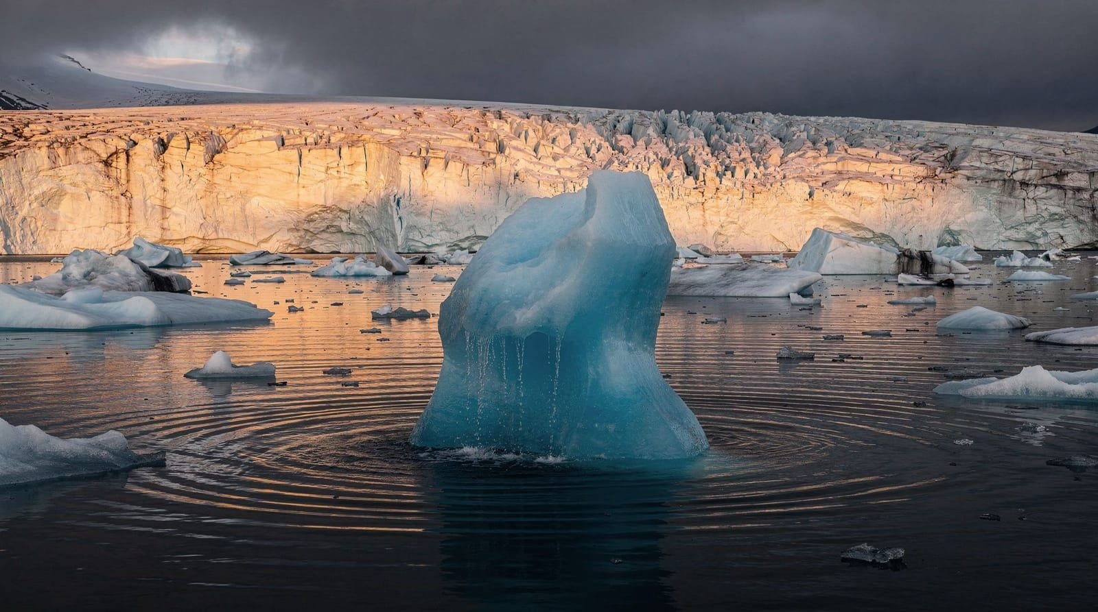
The glaciers are not static. Vatnajökull, Europe’s largest ice cap by volume, has lost approximately 10% of its mass since 1890. Some outlet glaciers (glacier tongues that extend from the main ice cap) are retreating at 50–100 m per year. The landscape is visibly changing — what the Jökulsárlón glacier lagoon looks like today is different from what it looked like 30 years ago and will be different again in another 30.
This is both a reason to go and a context for understanding what you’re seeing.
Iceland’s main glaciers
Vatnajökull — Europe’s largest ice cap by volume
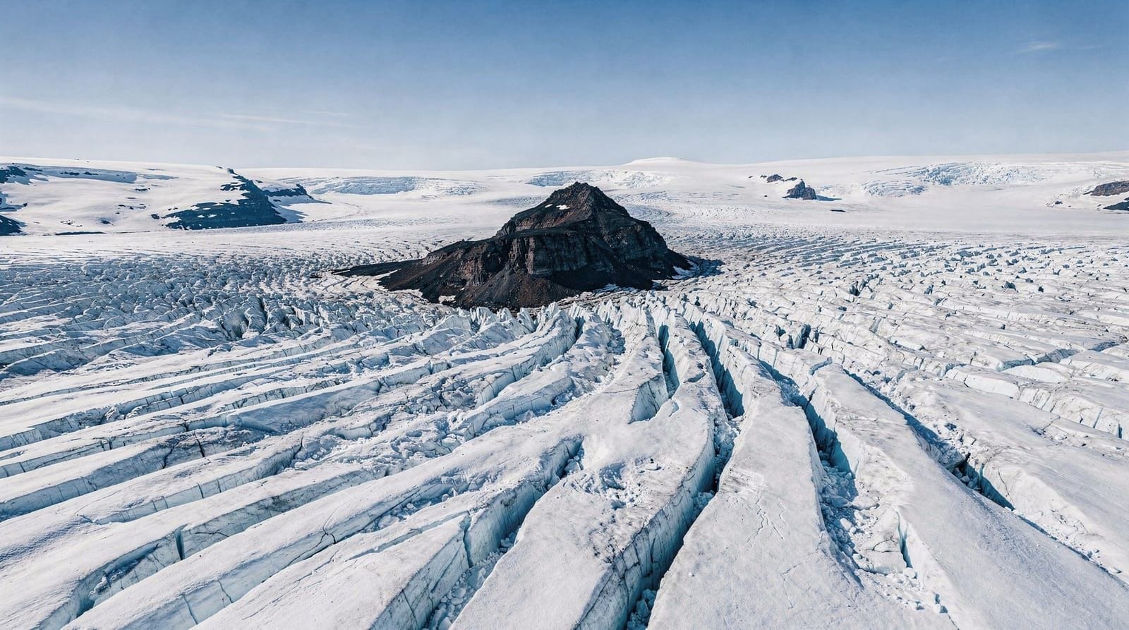
Vatnajökull covers 7,900 km² in southeast Iceland and reaches up to 950 m in depth. The ice cap covers multiple active volcanoes, including Grímsvötn (Iceland’s most frequently active volcano) and Bárðarbunga. Subglacial eruptions beneath Vatnajökull cause jökulhlaup — sudden glacial floods that can discharge millions of cubic metres of water within hours.
The accessible outlet glaciers from Vatnajökull include:
- Skaftafellsjökull: Accessible from Skaftafell visitor centre in Vatnajökull National Park. A 45-minute walk from the car park reaches the glacier snout. Free to approach, guided hikes required to go on the ice.
- Svinafellsjökull: 3 km east of Skaftafell. Smaller, less visited. Dramatic when seen from the viewpoint above.
- Breiðamerkurjökull: The glacier that feeds Jökulsárlón glacier lagoon. Viewable from the lagoon shore.
- Falljökull and Virkisjökull: Accessible from Skaftafell area, quieter options.
A guided glacier hike on Vatnajökull at Skaftafell covers the basics of glacier travel — crampons, ice axe use, crevasse awareness — in a 3–4 hour experience. You walk on the main glacier surface and see crevasses, ice formations, and glacial features up close. Required for anyone without glacier travel experience.
Langjökull — the “Long Glacier”
Langjökull is Iceland’s second-largest glacier at 925 km², located in the western highlands roughly 100 km northeast of Reykjavík. It is the water source for the Hvítá river system that feeds Gullfoss.
Langjökull is notable for the Into the Glacier tunnel — an artificial tunnel drilled into the ice from the surface, allowing visitors to walk inside the glacier through carved ice corridors. It is open year-round (unlike natural ice caves). Access requires a specially-modified glacier vehicle and a 45-minute drive from the highland road.
The natural surface of Langjökull is accessible for snowmobile tours (year-round, conditions permitting) and skiing. The glacier is about 500 m deep at its thickest point — the tunnel goes down about 30 m.
Mýrdalsjökull and Sólheimajökull
Mýrdalsjökull (596 km²) covers the Katla volcano on the south coast. Its most accessible outlet is Sólheimajökull, approximately 180 km east of Reykjavík. This is the easiest glacier to access in Iceland — a well-maintained 1.5 km footpath from the road leads to the glacier snout.
Sólheimajökull is heavily used for guided glacier walks and is the starting point for many operator tours. The glacier has been retreating visibly — markers show where the ice front was in previous decades. It is interesting precisely because the retreat is so visible.
Self-guided walking onto Sólheimajökull without crampons and a guide is not permitted by the operating tours and is genuinely unsafe — hidden meltwater channels and unstable ice seracs are not apparent from the surface. See the Sólheimajökull glacier hike guide for full details.
A south coast day trip from Reykjavík that includes Sólheimajökull glacier walk pairs the glacier experience with Seljalandsfoss, Skógafoss, and Reynisfjara — hitting all the major south coast highlights in one day. This is the most efficient option for visitors with limited time.
Eyjafjallajökull
The glacier made famous by the 2010 eruption, Eyjafjallajökull covers the volcano of the same name on the south coast. It is 100 km² in area and sits at 1,666 m altitude at the summit.
Access to the glacier surface requires a guided jeep or super-jeep tour — there is no standard hiking approach. The glacier can be seen clearly from the south coast road below. The farm Þórvaldseyri at the volcano’s base has a visitor centre explaining the 2010 eruption.
Snæfellsjökull — the glacier with a literary history
Snæfellsjökull (11 km²) sits at the tip of the Snæfellsnes Peninsula and was Jules Verne’s chosen entrance to the centre of the Earth in his 1864 novel. The glacier is much smaller than Vatnajökull but arguably more photogenic — it caps a 1,446 m peak visible across the water from Reykjavík on clear days.
Snæfellsjökull National Park surrounds the glacier. Guided snowmobile tours operate on the glacier surface (only accessible by snowmobile from the summit track). The upper glacier has been retreating dramatically — some forecasts suggest it could disappear by 2050.
Glacier hiking basics
You cannot walk on any Icelandic glacier without crampons and a guide. This is not a bureaucratic rule — it is a basic safety reality. Glaciers contain:
- Crevasses: Vertical cracks in the ice, sometimes 30+ metres deep, often hidden under snow bridges. Invisible from the surface until you’re on top of them.
- Moulins: Vertical shafts where meltwater drains through the glacier. Also hidden under snow.
- Seracs: Unstable ice towers that can collapse without warning.
- Meltwater channels: Fast-flowing water on or within the ice.
Guided tours provide crampons, ice axes, and the knowledge to navigate all of the above safely. The cost of a standard 3-hour glacier walk is approximately 10,000–15,000 ISK (~€65–100 per person). This is not overpriced for what is being provided. See the glacier hiking Iceland guide for operator comparison.
Ice caves — seasonal access
Natural ice caves in Vatnajökull are accessible from approximately October to April, when temperatures are cold enough to keep the cave stable. In summer, warm temperatures melt the cave ceilings and make them structurally unsafe.
The most popular ice cave experiences are in the Breiðamerkurjökull glacier tongue near Jökulsárlón. Tours depart from the glacier lagoon area. See the full breakdown in the Vatnajökull ice cave guide and ice caving Iceland guide.
Katla ice cave tours (in Mýrdalsjökull) are available year-round because they are geothermal — the heat from Katla volcano keeps a section of cave stable regardless of season.
Glacial retreat and climate context
Iceland has lost approximately 10% of its glacier coverage since systematic records began in 1890. Vatnajökull’s outlet glaciers are retreating at an average of 40–60 m per year. At current rates, Iceland could lose 30–50% of its glacier area by 2100.
Okjökull, Iceland’s first glacier to be classified as dead (no longer moving), was officially memorialized with a plaque in 2019. It covered 16 km² in 1890; by 2019, it was 0.7 km².
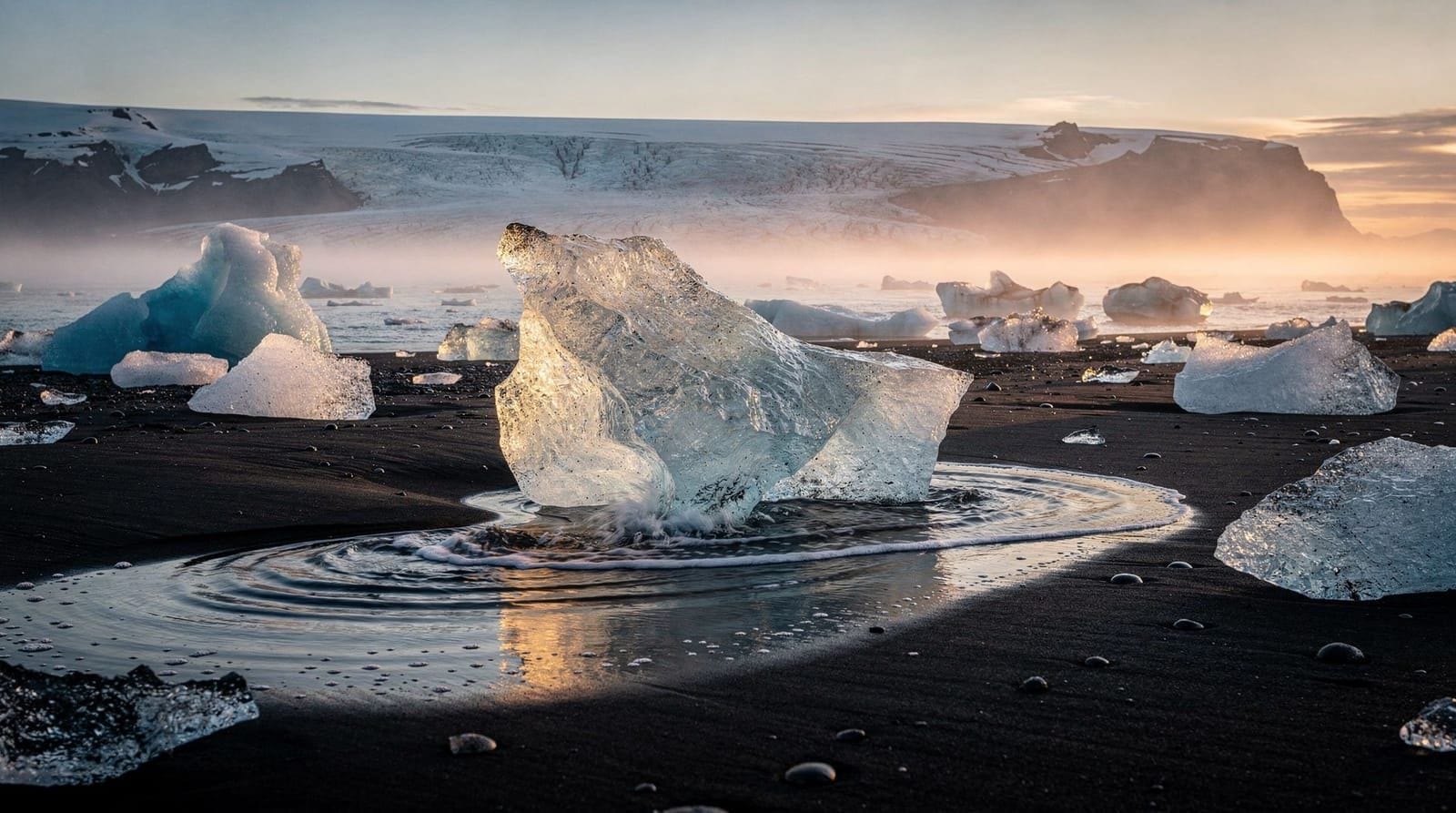
This is not a reason to feel guilty about visiting — it is a reason to understand what you’re seeing. The Jökulsárlón glacier lagoon exists because of glacial retreat: the lagoon is only about 80 years old, created as Breiðamerkurjökull pulled back from the coast. The icebergs floating in it are pieces of the living glacier.
Frequently asked questions about Iceland’s glaciers
Is it cold on an Icelandic glacier?
Yes, but not as extreme as some visitors expect. Summer temperatures on the lower sections of south coast glaciers (Sólheimajökull, Skaftafell) are typically 0–8°C. Wind chill is significant. A good windproof jacket, gloves, and warm mid-layer are essential even in July.
How long does a typical glacier walk take?
Standard guided glacier walks on Sólheimajökull and Skaftafell run 3–4 hours including transport from the trailhead and briefing. Longer “extreme” hikes on Vatnajökull summit glaciers take 6–8 hours. The initial 30 minutes are spent learning crampon use and the guide’s safety briefing.
Are glacier walks suitable for children?
Yes, for children aged 8 and above on most standard tours. The physical demands are moderate. Check minimum age requirements with specific operators — most set 8 or 10 as the minimum. Young children are best taken on the shorter intro walks at Sólheimajökull rather than longer glacier traverses.
What is the difference between an ice cave and a glacier walk?
Glacier walking is on the glacier surface — you walk on the ice with crampons, guided by a rope if near crevasses. Ice cave exploration is inside the glacier, through naturally or artificially formed tunnels. Both are guided; both are worthwhile. Ice caves are seasonal (October–April for natural caves); glacier walking is year-round.
Can you see crevasses on a glacier walk?
Yes. Guides specifically take you near (but not into) crevasses as part of the educational experience. Seeing a 30-metre deep crack in blue ice up close is one of the more memorable moments in Icelandic tourism.
Which glacier is easiest to get to from Reykjavík?
Langjökull is the closest by distance (100 km) and accessible via the tunnel year-round, though the highland approach requires a super-jeep transport. Sólheimajökull (180 km on the south coast) has the most straightforward drive on paved roads and the most guided tour options.
The colour of glacier ice — why it varies
Glaciers produce ice in a range of colours that tells you something specific about the ice’s age and composition:
White: Contains many air bubbles — typical of recently compacted snow (firn). White ice is young, relatively speaking.
Blue: Compressed over centuries, air squeezed out. The ice preferentially absorbs red wavelengths and reflects blue. The deeper blue the ice, the older and denser it is. Blue ice in Iceland is typically 200–1,000 years old.
Black or dark grey stripes: Volcanic ash layers deposited on the glacier surface during eruptions, then compressed into the ice. Icelandic glaciers have visible ash bands corresponding to historical eruptions. The 1783 Laki eruption ash is detectable in Vatnajökull ice cores.
Turquoise to greenish: Sometimes visible in icebergs at Jökulsárlón — a combination of density, algae, and impurities. The most dramatic turquoise in Iceland appears in Stuðlagil canyon river, which is fed by the same glacier meltwater system.
Glacier tours — what they actually cost
Being specific about pricing helps avoid surprises:
Sólheimajökull standard glacier walk (3 hours):
- 12,000–16,000 ISK (~€78–105) per person
- Includes crampons, ice axe, helmet, harness if needed
- Transport to glacier snout from car park is usually part of the tour
Vatnajökull Skaftafell glacier hike (3–4 hours):
- 12,000–18,000 ISK (~€78–118) per person
- Similar inclusions
Langjökull tunnel (Into the Glacier):
- 19,900 ISK (~€130) per adult including super-jeep transport from highland road
- The total time is about 3 hours including travel
Natural Vatnajökull ice cave (seasonal, October–April):
- 15,000–25,000 ISK (~€98–163) per person depending on operator and cave location
- Tours typically 2–3 hours
Zodiac boat tour on Jökulsárlón:
- 14,000–17,000 ISK (~€93–112) per person
- 60–90 minutes
All prices are 2025–2026 estimates — verify with operators before booking.
What happens when Iceland’s glaciers disappear
Iceland has already lost several small glaciers entirely. Okjökull was officially declared dead in 2019. Scientists forecast that at current rates, Iceland could lose 30–50% of glacier area by 2100, with small glaciers like Snæfellsjökull potentially disappearing within decades.
For tourists, this means: what you see now is not what future visitors will see. Snæfellsjökull, the Jules Verne gateway to the centre of the Earth, is visibly smaller than in historical photographs. Sólheimajökull markers show the glacier front retreating 50–100 m per year.
This is not a reason to feel guilty about visiting — the tourism itself is not causing the glacier loss. But it is a reason to go now rather than waiting, and to appreciate what you’re seeing as a specific moment in a changing landscape.
The Diamond Beach at Jökulsárlón literally exists because of glacial retreat — the lagoon and beach were created as the glacier pulled back from the sea. The icebergs you see on the black sand are pieces of a glacier that is actively disappearing. This context doesn’t diminish the beauty; it adds a different kind of weight to it.
Planning a glacier-focused Iceland trip
Iceland’s glaciers are distributed across three main regions, each requiring different trip planning:
South coast glaciers (accessible from Reykjavík, 180–375 km):
- Sólheimajökull: best for first-time glacier walking, daily tours
- Skaftafell/Vatnajökull: longer drive (320 km) but the most extensive glacier walking options
- Jökulsárlón/Breiðamerkurjökull: the boat tour and iceberg lagoon experience
A south coast glacier day trip covering Sólheimajökull glacier walk and Jökulsárlón is approximately 750 km return from Reykjavík and requires 12–14 hours total. Most visitors sensibly do this over 2–3 days. The south coast glaciers 4-days itinerary covers this properly.
Langjökull (100 km from Reykjavík): The closest glacier to the capital. Access via the highland road (4WD super-jeep provided by the tunnel operator). Year-round, which makes it useful in winter when south coast glacier access may be complicated. Combine with the Golden Circle for a full day.
West Iceland — Snæfellsjökull (190 km from Reykjavík): The Snæfellsnes Peninsula glacier is accessible on guided snowmobile tours from the summit access track. The Snæfellsnes day trip guide combines the glacier with coastal walking and Kirkjufell.
The inside of a glacier — what the tunnel experience is like
The Langjökull tunnel (marketed as “Into the Glacier”) was drilled into the ice starting in 2015 and opened in 2015. The tunnel descends approximately 30 m below the glacier surface and extends 500 m horizontally, with carved chambers, viewing windows into the glacier ice layers, and a chapel carved from ice.
The experience is unlike glacier walking because you’re completely surrounded by ice — floor, walls, ceiling. The temperature inside is consistently around -2°C regardless of outside conditions, which makes it genuinely cold in summer and relatively mild in winter. The tunnel is lit from within, so the ice appears brilliantly blue and illuminated.
Access to the tunnel requires the operator’s super-jeep transport — the track to the glacier surface is not accessible in a regular vehicle. The total experience (driving to the glacier, tour time, return) runs about 3 hours. Booking well in advance in summer is essential.
Glacier terms you’ll hear on tours
Terminus (or snout): The lowest end of the glacier — where the ice ends and the moraine (gravel and rock debris) begins. This is the point the tour operator usually walks you to before putting on crampons.
Moraine: Rock and debris deposited by the glacier. The moraine at Sólheimajökull shows markers indicating the glacier’s position in previous decades — a visible timeline of retreat.
Crevasse: A crack in the glacier ice formed by differential movement between the glacier’s surface and base, or between sections moving at different rates. Depth ranges from a few metres to 30+ metres. The primary reason guided tours are required.
Sérac: An unstable tower of glacier ice, typically formed in areas of compressed crevassing. Seracs can collapse without warning.
Bergschrund: A crevasse at the top of a glacier, where the moving ice separates from the stationary ice or rock face above it. Only visible on longer summit hikes.
Ablation zone: The lower part of the glacier where melting exceeds snowfall accumulation — the shrinking zone.
Accumulation zone: The upper glacier where annual snowfall exceeds melt — the growing zone. On most Icelandic glaciers, the ablation zone is currently expanding and the accumulation zone shrinking.
Top experiences
Bookable activities with verified prices and instant confirmation on GetYourGuide.

Top experiences
Best-rated activities across GetYourGuide and Viator.

Ice Cave by Katla Volcano Super Jeep Tour from Vik
- Viator

Puffin and Volcano Tour with Ebbi
- Viator

Dynjandi Waterfall & Farm Visit Tour from Isafjordur Port
- Viator

3,5-Hour Sightseeing Tour To Dynjandi Waterfall
- Viator

Volcano ATV Tour
- Viator

Lake Myvatn Day Tour and Godafoss Waterfall for Cruise Ships from Akureyri Port
- Viator