The volcano that erupted while we were in Iceland
The morning the news arrived
We were eating breakfast at our Reykjavík guesthouse — skyr, rye bread, the usual — when our host looked at her phone and said something in Icelandic that clearly was not routine. She translated: Fagradalsfjall, the volcano on the Reykjanes Peninsula about 40 kilometres from the city, had started erupting. Not a destructive event. A lava flow in an uninhabited valley called Geldingadalur.
It was March 2021 and this was Iceland’s first volcanic eruption on the Reykjanes Peninsula in 781 years. That number bears sitting with.
By 11 a.m. we were in the car.
Getting to the eruption site
The trailhead for Geldingadalur starts at a parking area on the Suðurnes road near Grindavík. In the weeks after the eruption began, this became one of the most visited places in Iceland. Icelanders drove out in their thousands; queues backed up on the highway. The Icelandic Road Administration eventually created new parking areas and improved the trail to handle the volume.
In August, when we visited, the trail was well-established and about 8 kilometres return from the main parking area — roughly 2.5 to 3 hours of moderate hiking on lava rock paths. Poles are useful. The terrain is not difficult but it is uneven, and on a warm day the radiated heat adds to the effort.
What surprised us was the organization. Icelandic emergency services (Almannavarnir) and the police monitored the site constantly, with a team on the crater ridge. When gas readings or wind direction became unfavourable, they closed the viewing area without negotiation. This happened twice while we were there, both times with a calm efficiency that reflected the fact that these were people who had been managing an eruption for five months and had developed procedures.
If you want a guided hike to the eruption area with a geologist or expert local guide explaining the volcanic context, small group tours from Reykjavík are the most informative option. They handle the gas-reading logistics and provide the geological backstory the landscape demands.
The approach: lava everywhere
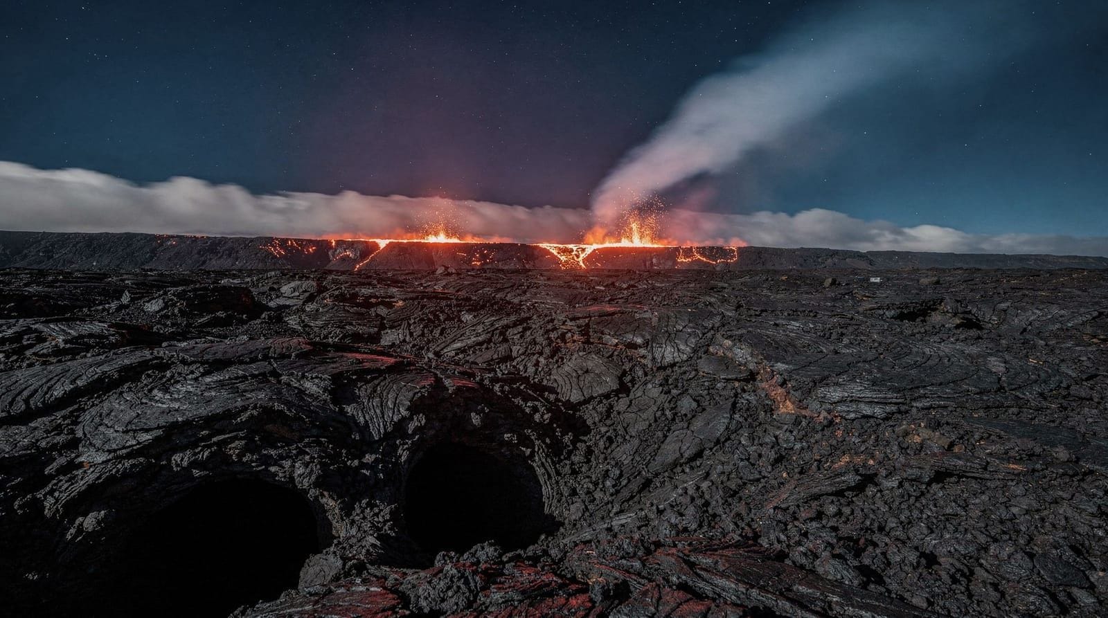
The first thing you notice is the scale of the lava field. Fagradalsfjall’s eruption produced new lava continuously from March to September 2021 and then again in subsequent eruption phases in 2022 and 2023. The flow covered over 4 square kilometres and reached depths of up to 30 metres in some valleys.
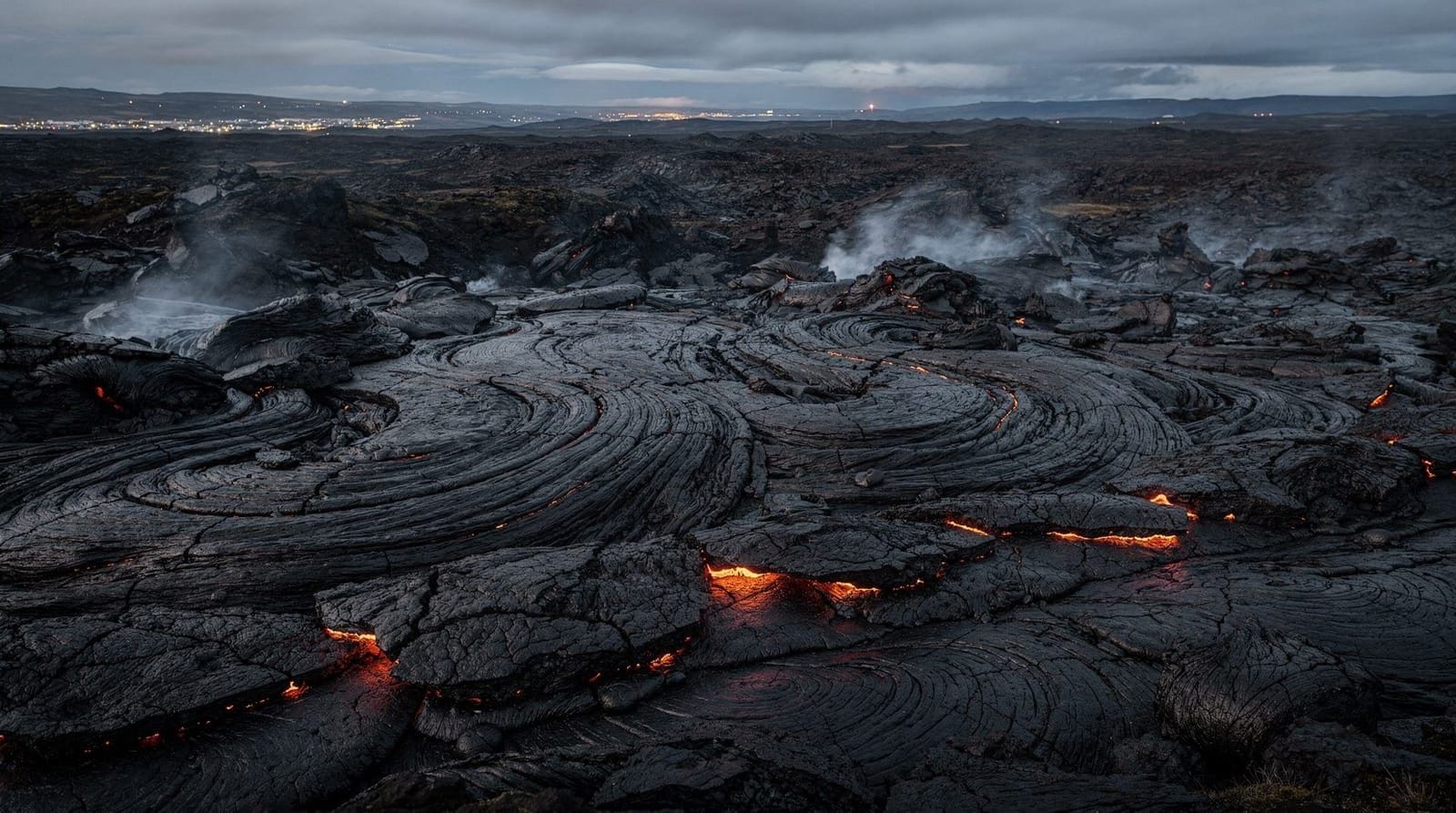
Walking across cooling but still-radiating lava has a specific quality that I had not anticipated: the rock looks ancient but isn’t. In places we could see fresh squeeze marks where lava had oozed between older crusted flows — surfaces that were weeks or months old rather than centuries. The geologic timescale compressed to something you could observe with your own eyes.
The colour spectrum of recent lava is more varied than photographs show. The oldest exposed surfaces were black and glassy. Slightly newer flows showed silver, blue-grey, and rust tones. Active lava advancing at the margins glowed orange-red in the shade, fading to grey on exposed surfaces where the crust cooled within seconds.
The heat was a physical presence even metres from the active margins. Standing on a cooling flow that was, according to the ranger, three days old, the ground was warm through the soles of heavy boots. In August this adds to the effort of hiking; bring more water than you think you need.
Standing at the rim
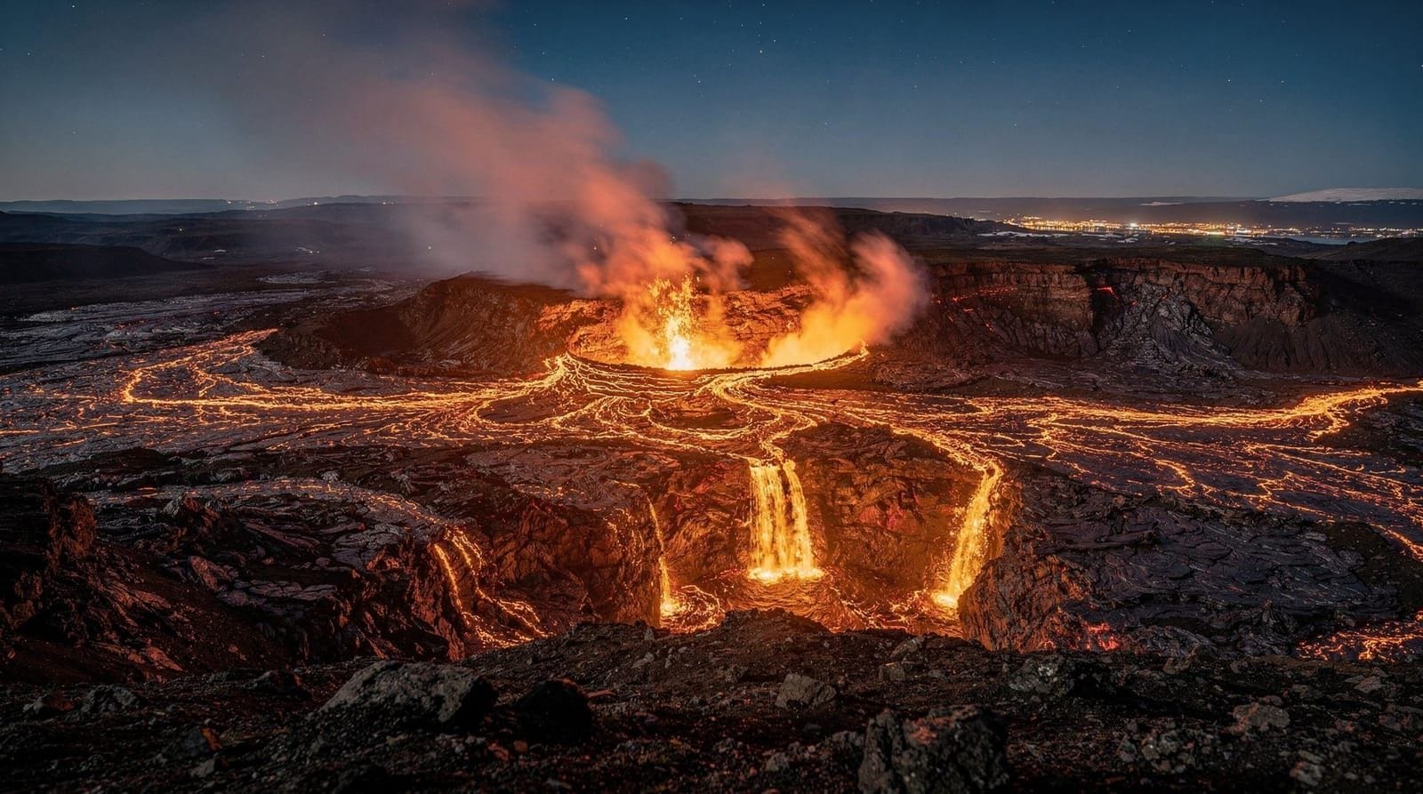
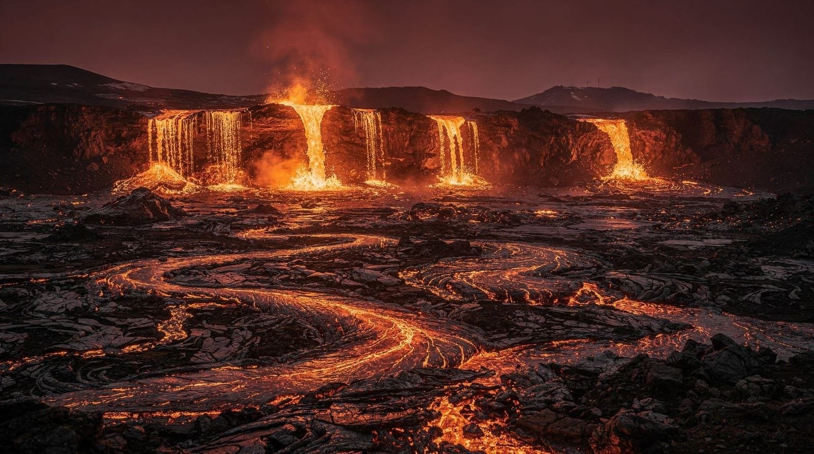
The active vent in August 2021 was no longer the original cone but one of several new vents that had opened over the summer. From the designated viewing area — an elevated ridge maybe 150 metres from the main activity — we could see the lava lake inside the crater and, on the downslope, the channelled flow heading west into the accumulated field.
The sound is the detail no photograph or drone video captures. Lava moving through channels makes a low crackling, like a bonfire but deeper and without the sharp snapping. The main vent itself produced a rhythmic chuffing noise — pressurized gas releasing in waves — that synced with the visible pulsing of the lava lake surface. Every few minutes the surface would swell and overflow slightly into the channel, and the glowing orange would advance a few metres.
The smell is sulphurous, mineral, and if you catch the wrong gust, genuinely unpleasant. Volcanic gas — primarily sulfur dioxide — is heavier than air and collects in low points. The monitoring team was tracking this. At one point, a ranger with a gas meter walked down the ridge toward us, shook his head slightly, and we all moved uphill without discussion.
The geology in context
The Reykjanes Peninsula sits atop a volcanic system that had been dormant for the 781 years before 2021. The peninsula’s ridge system connects, roughly, to the Mid-Atlantic Ridge — the boundary between the North American and Eurasian tectonic plates that also runs through Þingvellir on the Golden Circle. Iceland exists because of this boundary; the island is essentially the exposed section of the Mid-Atlantic Ridge where the spreading has produced enough volcanic material to breach the surface.
What made the 2021-2023 eruption sequence scientifically notable was the location — the Reykjanes volcanic belt had not erupted in recorded human memory — and the eruption style: what geologists call “effusive” rather than “explosive.” No ash cloud, no Eyjafjallajökull-style disruption to air travel. Just lava, flowing steadily, producing new land at a rate that was measurable in real time.
The Iceland volcanoes guide and the Fagradalsfjall eruption guide provide the geological background in detail. I read them after the visit and wished I had read them before; the experience of watching the eruption knowing the tectonic context would have been even more instructive.
The crowd dimension
We were not alone. There were perhaps 200-300 people at the site across the two hours we spent there. The remarkable thing was the behaviour: everyone was quiet. Icelanders were there — families with young children, elderly couples, groups of friends — and they stood and watched with an attentiveness that felt less like tourism and more like witnessing. The conversation, when it happened, was in low voices.
An Icelandic couple next to us had driven from Ísafjörður in the Westfjords — a 6-hour drive — specifically to see the eruption. “The last time a volcano erupted here was the Middle Ages,” the man said. “Our ancestors saw it. We should too.” This felt like the correct framework.
The international tourists at the site behaved differently — photographs, louder, more movement. I say this without judgment; it is a reasonable response to an extraordinary spectacle. But the Icelandic stillness around it was its own instruction. This was not an entertainment; it was a geological event happening on their island, to their land.
Practical logistics for the visit
In August 2021, the car parks at the trailhead were large and free. The hike to the main viewing area was marked with ropes and cairns over the lava. Emergency services had a tent near the crater for gas monitoring and first aid. Facilities: a basic portable toilet, no food or water.
Bring: at least 1.5 litres of water per person, solid footwear (the lava is sharp), and sun protection. In August the hike is moderate and fully exposed. The gas risk protocol was communicated at the trailhead: if a siren sounds, move upwind immediately.
If you are visiting a future eruption site on the Reykjanes Peninsula — the volcanic system has continued active with new eruptions near Grindavík since 2023 — the Icelandic Meteorological Office (vedur.is) and the Civil Protection (almannavarnir.is) post real-time updates. The Fagradalsfjall eruption guide has the current access status for all active areas.
The full-day hike to Geldingadalur from Reykjavík is the most thorough option for understanding the eruption landscape — the route covers the full extent of the lava fields and allows time to explore the various vent areas in sequence.
On the broader strangeness of it
Iceland has a relationship with volcanic activity that outsiders sometimes misread as casualness. Icelanders are not casual about it. They monitor it, plan for it, discuss it seriously. What they do not do is panic or treat it as exceptional in the existential sense. The Reykjanes Peninsula has been volcanically active since humans arrived. The sagas mention eruptions. The place names encode geological events.
The town of Grindavík, at the base of the peninsula, was evacuated in late 2023 and early 2024 when eruptions approached the town perimeter. This was a serious event — people leaving homes, lava breaching defence berms. The response was measured and organised. This is what it looks like to live on a volcanically active island: not indifference, but competent preparedness developed over generations.
Standing at Fagradalsfjall in August 2021, watching something that had not happened in eight centuries and that was actively reshaping the surface of the earth, I felt neither terrified nor blithely entertained. It was closer to what people mean when they say awe: the recognition that you are very small and that the thing you are watching does not require your presence or your response.
We hiked back in the long summer evening. The glow from the vent was visible for the whole return trail. We had lamb soup for dinner in Grindavík and I thought about the Middle Ages for most of the drive back.