A week in the Icelandic highlands: Landmannalaugar to Kerlingarfjöll
What the highlands actually are
The Icelandic interior — known simply as “the highlands” (hálendið) — is the elevated, uninhabited centre of the island. No one lives here permanently. No roads are paved. There are no towns, no petrol stations, no reliable phone signal. What there is: vast lava fields, rhyolite mountain ranges in volcanic colours, hot spring rivers, glaciers, calderas, and geothermal areas that have been essentially unchanged since they formed.
The highlands are accessible only from approximately June through September — snow closes the F-roads (the letter F designates highland interior routes) outside these months, and even within the season, conditions can change rapidly. River crossing depths vary day to day depending on glacial melt.
We spent seven days in the highlands in September 2023. We had a Toyota Land Cruiser 200 (rented from Arctic Trucks in Reykjavik, ISK 38,000/€240 per day — significantly more expensive than standard 4x4 rentals, but genuinely appropriate for the terrain) and two weeks of experience driving Icelandic conditions from a previous ring road trip. Even so, there were river crossings that required careful assessment before entering.
This is not a trip for beginners or for anyone not comfortable with vehicle recovery scenarios.
Getting to Landmannalaugar
Landmannalaugar sits in the Fjallabak Nature Reserve, roughly 180 km from Reykjavik. Two route options: F26 Sprengisandur from the north (long, desert-like, multiple river crossings) and F208 from the south (more commonly used, still requires multiple river crossings). We used F208 from Route 1 near Hella.
The drive took four hours including two river crossings that were calf-deep on the car’s wheels — well within the Land Cruiser 200’s clearance, but not something you’d attempt in a standard Dacia Duster. We watched two Toyotas turn back at the first significant river crossing; they were in standard SUVs without the appropriate clearance.
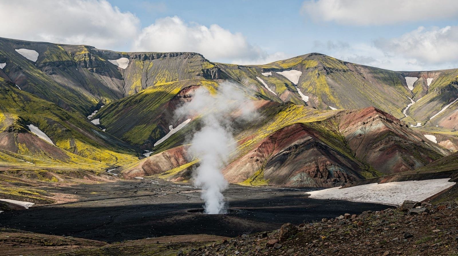
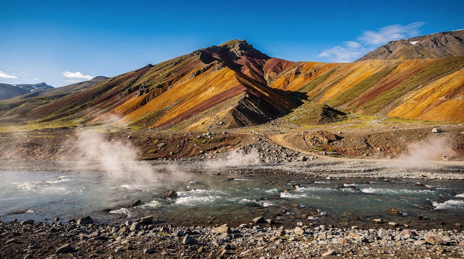
Landmannalaugar has a mountain hut (Ferðafélag Íslands, booking essential, around ISK 8,000 per person per night in the sleeping-bag room) and a campsite (ISK 1,800/person/night). We camped. The campsite is set against rhyolite mountains — volcanic rock oxidised into shades of red, yellow, green, and brown. The hot spring river runs along the edge of the campsite and is free to use. We soaked for 30 minutes on arrival, exhausted from driving.
Landmannalaugar hiking
The most popular day hike from Landmannalaugar is the Brennisteinsalda loop — a 12 km circuit around the distinctive yellow sulfur mountain that takes 4–5 hours. We did it on day two in clear weather. The route crosses obsidian lava fields (cooled volcanic glass, sharp and black), passes fumaroles venting sulfur gas, and ends with a view down over the entire Landmannalaugar basin.
The start of the Laugavegur trek also begins here — a 55 km multi-day trail to Þórsmörk. We didn’t have the logistics for the full trek (hut bookings, shuttle arrangements) but we walked the first 3 km toward Hrafntinnusker to see the obsidian fields and turned back.
If the Laugavegur trek is on your list, book hut accommodation 6–9 months in advance through the Ferðafélag Íslands website. The trail fills to capacity in July and August.
Guided day hikes in Landmannalaugar from Reykjavik remove the transport complexity if you don’t have an appropriate vehicle. The highland bus (Reykjavik Excursions) also runs direct service from Reykjavik to Landmannalaugar in summer, arriving mid-afternoon for a same-day return.Driving to Kerlingarfjöll
From Landmannalaugar, the route to Kerlingarfjöll requires returning to the ring road and heading north, then turning onto F35 (Kjalvegur) — the most accessible highland route, relatively flat compared to F208 and F26, but still gravel with several smaller river crossings.
Kerlingarfjöll is a geothermal mountain area with a distinctive landscape: pale grey and orange rhyolite peaks, steam rising from dozens of vents, and a network of hiking trails through the geothermal zone. The mountain hut/resort at Ásgarður (kerlingarfjoll.is) offers dormitory accommodation and meals at a price point around ISK 13,000–18,000 per person per night including breakfast and dinner — expensive but there are no other options within 80 km.
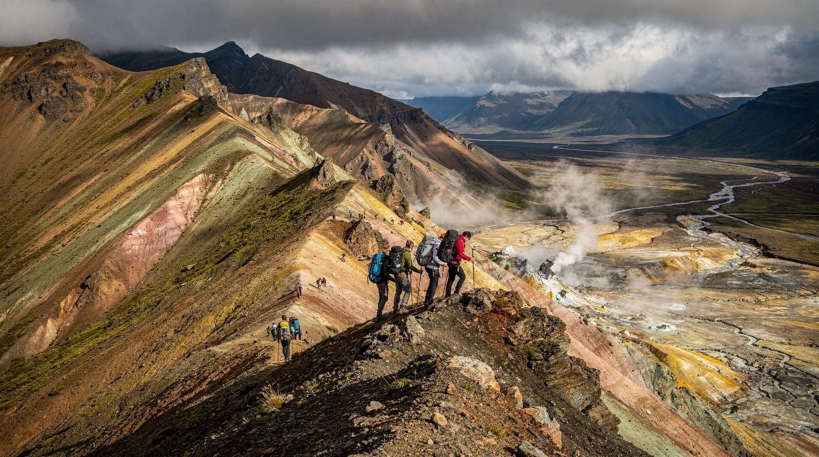
We spent two days hiking in Kerlingarfjöll. The Hveradalir geothermal valley is the centrepiece — a 2–3 hour circuit through fumaroles, boiling mud pools, and steaming orange earth. The smell of hydrogen sulfide is strong throughout. The terrain is warm underfoot in places.
The highland hot pools at Kerlingarfjöll — a series of small natural hot springs at the base of the peaks — are free to use and require no hiking beyond a 10-minute walk from the hut. We were there in mid-September and had one pool completely to ourselves for an evening.
Askja: the volcanic caldera
From Kerlingarfjöll, we drove further north via F88 toward Askja — a remote volcanic caldera that last erupted significantly in 1875 and still contains a warm, acid lake inside the crater. The drive on F88 requires crossing the Jökulsá á Fjöllum river, which was 80 cm deep when we crossed it. That’s the edge of what’s advisable in a fully loaded Land Cruiser 200.
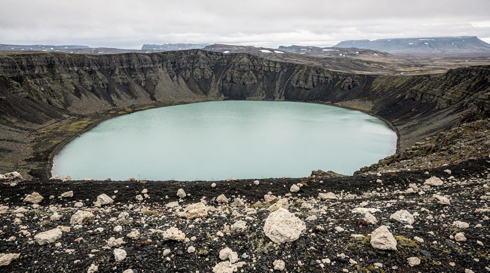
Askja itself requires a 3 km walk from the car park over grey volcanic ash and lava. The caldera lake (Öskjuvatn) is the largest lake in Iceland. Inside the caldera is a second, smaller lake (Víti) that formed in the 1875 eruption — warm geothermal water, pale blue, swimmable in summer. We swam in Víti on a clear September afternoon. The water was perhaps 25°C. The crater walls rose around us. It is one of the more improbable swimming experiences available.
The Mývatn area is the logical base for an Askja day trip — the drive is 2.5–3 hours each way from Mývatn on good days.
The honest accounting
Costs for seven days in the highlands:
- Toyota Land Cruiser 200 rental (7 days + daily rates): €1,680
- Fuel (approximately 900 km, heavy fuel consumption): €310
- Accommodation (6 nights camping + 1 night hut): €180
- Food (cooked at campsite, two restaurant meals at huts): €140
- Ferry/activities: €40
Total for one person (we split vehicle costs): approximately €1,175.
The Land Cruiser 200 rental is the biggest expense. It’s not optional for the rivers we crossed. A standard 4x4 would have required us to skip Askja (F88’s river crossing) and potentially couldn’t safely complete F208.
For someone who doesn’t want to drive, the 4-day highlands itinerary includes guided options. Several companies run highland day tours from Reykjavik by super-jeep that cover Landmannalaugar, Kerlingarfjöll, and Askja separately.
On the geology: what the highlands actually are
For anyone not already interested in volcanology: the Icelandic interior sits on the Mid-Atlantic Ridge, where the North American and Eurasian tectonic plates are slowly separating. The result is a landscape that’s geologically raw in a way that most of the earth’s surface isn’t — active fumaroles, fresh lava fields, calderas that erupted within living memory, glaciers retreating visibly year on year.
At Landmannalaugar, the rhyolite mountains are the result of slow-cooling silica-rich magma that produced these distinctive pale yellow, orange, and green mineral tones rather than the black basalt of faster-cooling lava flows. The obsidian — volcanic glass — scattered across the lava fields west of the Brennisteinsalda mountain is the result of extremely rapid cooling. You can pick up pieces and see yourself in their surface.
At Kerlingarfjöll, the geothermal activity is driven by a magma chamber approximately 3–5 km below the surface, heating groundwater that rises through the rock and emerges as steam vents and boiling pools. The orange colouration of the soil in Hveradalir valley is iron oxidation — the same chemistry that makes rust. The smell of hydrogen sulfide (H₂S) that permeates the geothermal areas is technically not dangerous in the concentrations you encounter hiking through them, though it’s sufficiently intense that you stop noticing it after about 15 minutes.
What to do if something goes wrong
Remote highland travel in Iceland requires specific preparation for problems. Our checklist:
Register your trip: safetravel.is has a trip registration system. Enter your route, vehicle, expected return date, and emergency contact. Mountain rescue (ICE-SAR) uses this information if you’re overdue.
Communication: Mobile signal is absent across most of the highlands interior. A satellite communicator (SPOT, Garmin inReach) is useful for emergency signalling. We had a Garmin inReach Mini. We didn’t need it.
Vehicle recovery: Know how to change a tyre on your rental vehicle before you’re in a remote location doing it. Carry a hi-lift jack in addition to the rental’s standard equipment. Know your towing point locations on the vehicle.
River crossing protocols: Stop before all crossings. Get out and walk the crossing on foot if uncertain about depth. Cross at the widest, shallowest section. Do not cross if water is above the door sill. Do not follow another vehicle’s crossing immediately — the sediment they disturb reduces visibility.
The highlands deliver a version of Iceland that the ring road doesn’t. No crowds, no infrastructure, no mobile signal for five days. The psychological reset that produces is real and somewhat difficult to explain to people who haven’t experienced it. Book your flights.